[Marker Front]:
At the close of the Seminole War in 1842, this frontier was opened to settlement. Major Robert Gamble and other sugar planters soon located along the rich Manatee River valley, and by 1845 a dozen plantations were producing . . . — — Map (db m15665) HM
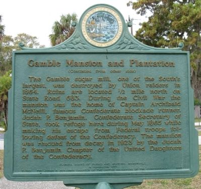
Secretary of State Benjamin of the Confederate Cabinet lived in this house between the capture of Richmond, VA, by the Union Army and his escape to England.
This building and the site were purchased by Friends of the Confederacy and . . . — — Map (db m218390) HM WM
William Iredell Turner was born in Richmond, Virgina and grew up in Alachua County, Florida, where he spent his early adulthood as a cattle rancher. He became a major with the Florida Volunteers in the Second Seminole War (1835-1842). He later . . . — — Map (db m200001) HM
Side 1
Rye was once a thriving settlement along the Manatee River named after Erasmus Rye, who moved to the area in the mid-1840s from Hanover County, Virginia. In 1861, Erasmus married Mary Lucebia Williams, whose family owned the largest . . . — — Map (db m214570) HM
Side 1:
Miguel Guerrero (aka Gerrero), a Menorcan sailor (b. 1817), established a fishing rancho here at Boots Point in 1848 on the site of a prehistoric Indian village. In 1856, Miguel met Julia Atzeroth's niece, Frederica Kramer (b. . . . — — Map (db m241682) HM
Victorian home with Carpenter Gothic architectural style. The residence of W.S. Bullock, Mayor and Judge in late 19th and early 20th century. Son of Civil War General Robert Bullock. — — Map (db m189502) HM
The first national flag of the Confederate States of America, also called the “stars and Bars,” was adopted by the Confederate government in March of 1861, during the war between the Union and Confederacy.
Florida seceded on January 10, 1861 . . . — — Map (db m198355) HM
CSS Submarine Hunley
Commander
1st LT. George E. Dixon - 21st ALA Inf.
Crew
C.F. Carlson
Arnold Becker
James A. Wicks
Carl Simpkins
Frank Collins
Joseph Ridgeway
Miller
Commanded by Confederate . . . — — Map (db m199055) WM
Fredericksburg, VA
December 1862
Casualties
U.S.A. …12,700
C.S.A. …. 5,300
Deo Vindice
Frederick Dinkins, 1812 War vet and son of Rev soldier John Dinkins, had five family members defend the CSA at . . . — — Map (db m198026) WM
Captain John J. Dickison moved to Orange Lake (Marion County) and was a plantation owner. Served as 1st LT. in Marion Light Artillery. Later formed 2nd Florida Cavalry Co. H. commanding mostly less than 300 soldiers. Relied on guerrilla actions to . . . — — Map (db m199030) WM
On May 1, 1908, the John J. Dickison Chapter of the United Daughters of the Confederacy (UDC) dedicated this monument to honor the Confederate dead. To erect the monument, the UDC collected $1,500 from its members, schoolchildren (donating pennies), . . . — — Map (db m90555) HM WM
A short distance north of here stood the sugar plantation of Jehu Foster Marshall, established in 1855. At the start of the Civil War in 1861, Marshall was named a colonel in the Confederate Army and soon commanded one of General Wade Hampton's . . . — — Map (db m167953) HM
Shenandoah Valley
&
Peninsula Campaigns, VA.
March - June 1862
Casualties
U.S.A. …22,000
C.S.A. … 22,700
Deo Vindice
Mexican War vet George W. Scott, our forefather, served the CSA Co I, 7th Va Cav with . . . — — Map (db m198045) WM
U.S.S. Monitor
vs
C.S.S. Virginia (Merrimack)
March 1862
Casualties
U.S.A…..1
C.S.A…10
Sponsored by: Friends and Visitors to the Park — — Map (db m198065) WM
War Between the States
1861-1865
The Price in Blood
Casualties
Confederate States of America
Battle Deaths … 74,524
Disease, etc…… 90,297
Total…………… 164,000
United States of America
Battle Deaths . . . — — Map (db m198025) WM
The first paddle-wheel steamboat to operate in northeast Florida was the Florida in 1834, running once a week from Savannah, Georgia to Picolata on the St. Johns River. After the Civil War, in late 1860s, travelers from northern states . . . — — Map (db m132199) HM
In 1897 Mrs. Mary Brickell sold this 10-acre “rocky wasteland” to the City of Miami for $750. It was a half mile north of the city limits on a narrow wagon county trail. The first burial, not recorded, was of an elderly black man on 14 . . . — — Map (db m78119) HM
Professor Charles Torrey Simpson
Charles Torrey Simpson was born on June 3, 1846, in Tiskilwa, Illinois. From a young age, Simpson had a love of nature. In his early life, Simpson worked as a farmer, miner, carpenter, and cowboy. During . . . — — Map (db m146361) HM
In 1873 Fort Jefferson's armament was modernized to include six 15-inch Rodman smoothbore cannon and four 300-pounder rifled Parrott guns. Of the 141 guns listed at the fort when the garrison left in 1874, only those 10 remain here today. The other . . . — — Map (db m193412) HM
In January of 1863, Col. James Montgomery of Kansas was authorized to raise a regiment of troops consisting entirely of free blacks and former refugee slaves. The following month, he arrived in Key West to recruit men for that regiment.
All . . . — — Map (db m224902) HM WM
Notice the design of the fountain below. It was built by Asa Tift in 1862 and replicates the cutting edge warship design he and his brother, Nelson, developed for the Confederacy—the Ironclad Warship.
The Confederate Secretary of Navy, a friend . . . — — Map (db m246967) HM
Model 1844 8-inch Columbiad
The original guns brought to the Fort in 1856. Two guns were recovered in the early 1980s from the base of the concrete foundation of Battery Osceola.
Model 1858 10-inch Columbiad
Later addition to Fort . . . — — Map (db m240184) HM
Other than bread, fish, shrimp, and turtles, most of the food—salted pork, salted beef, and beans—came from the mainland. Officers fared better than the soldiers and prisoners. "The bread was a mixture of flour, bugs, sticks and dirt," Lincoln . . . — — Map (db m248002) HM
In 1863, during the height of the Civil War, Fort Jefferson was a bustling little city. Laborers, prisoners, and enslaved blacks swatted mosquitoes as they struggled in the broiling sun to complete this massive fort. Soldiers of the 47th . . . — — Map (db m240093) HM
In the middle of the night of January 13, 1861, three days after Florida had seceded from the Union, Capt. James M. Brannan, U.S. Army, marched his troops from their barracks on the northeastern side of the island to Fort Taylor on Key West's . . . — — Map (db m224146) HM WM
Following President Lincoln's order for a naval blockade of Confederate ports in 1861, the U.S. Navy established the East Gulf Blockading Squadron based at Fort Jefferson, Fort Taylor, and the port of Key West. The squadron's area of operations . . . — — Map (db m246010) HM
This monument represents two perspectives on how the Civil War affected the residents of Key West. The obelisk in the center of the memorial plot was erected by the Navy Club of Key West for the Union soldiers who lost their lives in Key West during . . . — — Map (db m85270) HM
Building #1 is the oldest brick structure in Key West. It was built by the U.S. Navy as a coal depot and storehouse. Navy servicemen coordinated refueling steamships at this location from 1856-1900. During the Civil War, the Union's West Indies . . . — — Map (db m223008) HM
The Jeptha V Harris family moved from South Carolina to Mississippi, where he attended high school and graduated from the University of Mississippi. Jeptha studied medicine at the University of New York and South Carolina Medical College before . . . — — Map (db m223693) HM
During and after the Civil War, the US government used Fort Jefferson as a prison for hundreds of military deserters and convicts, but a civilian was the fort's most famous prisoner. Dr. Samuel A. Mudd arrived at the fort in July 1865 with three . . . — — Map (db m240137) HM
This is one of three Civil War era forts on the island. Construction began in 1862 making it part of a chain of fortifications that controlled Key West's maritime waterways. The architectural design is a Martello Tower, a Genoese defense system . . . — — Map (db m232191) HM
Fort Taylor was constructed in 1845 as part of the Third Tier System of Defense which called for the establishment of masonry fortresses constructed along America’s coastline to prevent sea attacks upon the United States. This fort was an important . . . — — Map (db m168313) HM
One of 3 civil war era forts built in Key West. At the onset of the Civil War, the Union seized control of the fort preventing it from falling into Confederate hands. It played an important role curtailing the threat of Confederate blockade runners. . . . — — Map (db m240149) HM
The 8- and 10-inch columbiads were standard U.S. cannon for coast defense. They were cast-iron, muzzle-loading smoothbores. The 8-inch weighed 9,210 pounds and when elevated 4” threw a 65-pound ball about a mile. From the top of the fort, the . . . — — Map (db m100238) HM
The Northwest Bastion provides an excellent view of the Key West Harbor. To the left (south) is the main ship channel and to the right (north) is the main harbor.
Blockade Headquarters
Key West was the headquarters of the East Coast . . . — — Map (db m240183) HM
In the Beginning
On December 22, 1968, Howard S. England and a small group of volunteers started an eight-and-a-half year quest at Fort Taylor. Using shovels and a borrowed civilian construction crane, they began the search for American Civil . . . — — Map (db m240162) HM
“...upon occasion of the prevalence of the yellow fever...Samuel A. Mudd devoted himself to the care and cure of the sick and interposed his courage and skill to protect the garrison...from peril and alarm, and thus...saved many valuable lives . . . — — Map (db m9305) HM
A fort's effectiveness in the 1800s depended in large part on its gunpowder supply. Keeping the powder dry and avoiding explosions were critical. This powder magazine's special features included wooden floors and walls to prevent sparks, and vents . . . — — Map (db m193408) HM
This 1903 armory was described as "an unusual wood-frame building," and was one of the few armories built in the South due to lack of funds following the Civil War (1861-1865). The Italianate-style, Key West Armory incorporates an arched entrance, . . . — — Map (db m85266) HM
The three-story Barrack located on the gorge, or landward side of the Fort, served as the center of life for its soldiers. Facilities included sleeping quarters, offices, chapels, kitchens, dining rooms, tidal-flushed latrines and an infirmary. Even . . . — — Map (db m240186) HM
History of Fort Taylor
Fort Taylor served faithfully through the American Civil War and was called the "Gibraltar of the Florida Straits", even though it never fired a single shot in defense. It protected the harbor from attack, and served as . . . — — Map (db m240152) HM
During the Civil War, soldiers lived in second-tier casemates like this one as the Union Army utilized every square inch of the incomplete fort. These rooms were breezier than the tents on the parade ground, but the mosquitoes, flies, and stench . . . — — Map (db m240117) HM
The home of Stephen Russell Mallory (1812-1873) stood near this site from 1839 to 1895 when it became U.S. Navy property. U.S. Senator from Florida from 1851 to 1861 and Chairman of the Naval Affairs Committee after 1853. As Secretary of the Navy in . . . — — Map (db m84721) HM
On September 13, 1833, the United States government purchased this harbor-front lot. The Naval Depot was authorized by an Act of Congress on July 21, 1852. Capt. J.M. Scarritt and Lt. J.J. Philbrick supervised the construction of this building. By . . . — — Map (db m128058) HM
Erected 1866
by the Navy Club of Key West
To the Memory of the
Officers, Sailors & Soldiers
of the
Army, Navy & Marine Corps
of the
United States
who lost their lives in their
Country's service upon this station
from 1861 to . . . — — Map (db m85331) WM
The military history of Peary Court dates from 1831 when the Key West army barracks was established. The earliest recorded burials in the post cemetery was in 1836, probably resulting from the yellow fever epidemic that led to the abandonment of the . . . — — Map (db m225461) WM
Imagine what it was like to heat solid cannonballs in a hot shot furnace like this one, so gun crews could fire red-hot projectiles at wooden warships to set them ablaze. This process involved several soldiers. One soldier maintained the coal fire . . . — — Map (db m193410) HM
The 300-pounder Parrot had spiral grooves, called rifling, which caused its elongated, pointed projectile to spin. This made the Parrotts much more accurate than smoothbore Rodman cannon that fired round cannonballs. The Parrot's muzzle-loaded . . . — — Map (db m225067) HM
The Only Way In
The Sally Port served as the only entrance to the Fort. It was accessed by crossing a 1,100 foot wooden causeway from the island. All personnel and goods entered and exited the Fort through the Sally Port. A moat and drawbridge . . . — — Map (db m240189) HM
Sandy Cornish (Uncle Sandie) was born a slave in Maryland about 1793. He migrated to Florida in 1839 where with his wife Lillah's help he was able to buy his freedom. In the late 1840's his free papers were lost in a fire. Six unprincipled men . . . — — Map (db m223513) HM
About 1820, Stephen Mallory came to Key West with his parents, Ellen and John. At that time his mother was one of the few women on the island. He attended school in Mobile and Nazareth, Pennsylvania. His widowed mother's boarding house was the sole . . . — — Map (db m223518) HM
The fort was not built as a prison, and it has no dungeons. But prison it became, and at times "hard cases" were clapped into magazines or secure gunrooms.
One man who knew this room was Dr. Samuel Mudd. He was shackled in irons after trying to . . . — — Map (db m246656) HM
It protected the fort walls from (1) heavy seas, and (2) enemy landings.
Most of the moat wall was built in 1849-1851, but digging the moat to full depth, a task for prisoners, was not completed until 1873.
Beginning in 1861, dozens of . . . — — Map (db m225073) HM
Fort engineers designed an innovative system to collect and store rainwater to provide fresh water for the islands 1500 planned residents.
Garden Key receives about 30 inches of rain a year. Rain falling on the fort's top tier filtered down . . . — — Map (db m193731) HM
This structure is one of three Civil War era forts in Key West. They were built as a defensive chain around the island and support for Fort Jefferson in the Dry Tortugas. No cannons were ever fired and no soldier died in battle at this . . . — — Map (db m85261) HM
This green, picket-lined field is a military cemetery. Many of the grave sites originally held the remains of Civil War soldiers who died from yellow fever. More soldiers were struck down in the South by disease than by armed skirmishes. Yellow . . . — — Map (db m223068) HM
Built in 1885 by George Rainsford Fairbanks, lawyer, historian, and editor. Born in 1820 at Watertown, New York, Fairbanks moved to Florida in 1842 and became a major in the Confederate Army.
He edited the Fernandina Florida Mirror, presided . . . — — Map (db m59696) HM
Organized in 1858, this congregation worships
in Fernandina's oldest church building, and
one of the oldest in Florida. This colonial
structure rests on land donated by David L.
Yulee, Florida's first Senator, and a former
member of the . . . — — Map (db m121847) HM
Reconstruction and construction of roads, buildings and grounds was performed by Civilian Conservation Corps
Company 1420, 1937-1942. — — Map (db m33457) HM
You are standing in the general location of the Fort Clinch Military Road. The photo represents what a typical military road looked like during the Civil War.
In 1847, with the start of the fort's construction, military engineers realized the . . . — — Map (db m33438) HM
In 1847, with the start of the fort’s construction, military engineers realized the necessity to create a road that would connect Fort Clinch to Old Fernandina. The road would serve as a vital lifeline for the movement of soldiers, supplies and . . . — — Map (db m144854) HM
Plaza San Carlos, located atop a bluff of the Amelia River in Old Town, is one of the most historically significant places on Amelia Island. The area was inhabited by Native Americans of St. Johns culture as early as 1000 BC, and was later used . . . — — Map (db m144885) HM
In 1855, construction began in Fernandina on the first railroad in Florida to connect the Atlantic Ocean and Gulf of Mexico. The final tracks were completed in Cedar Key in March 1861 just a month before the start of the Civil War. Named the Florida . . . — — Map (db m153377) HM
Cathay Williams was born to an enslaved mother and a free father in Independence, Missouri in 1844. During her adolescence, she worked as a house slave on the Johnson plantation on the outskirts of Jefferson City, Missouri. In 1861, Union forces . . . — — Map (db m192285) HM
Originally called Camp Walton, this Confederate installation, constructed in 1861 to guard East Pass, was garrisoned by a company of Florida militia called the "Walton Guards". Several small skirmishes with federal landing parties occurred near . . . — — Map (db m110313) HM
Side 1
The Indianola Inn, the second hotel in this area, was built on this midden mound in 1912 – the only structure ever permitted to do so. The inn burned in 1962, but the steps, foundation parts, and well head have been . . . — — Map (db m99232) HM
(Side one): To the honored memory of The Soldiers, The Sailors, The Statesmen of the Confederate states of America. "Time cannot teach forgetfulness when grief's full heart is fed by fame." (Side two): "Tis wreathed around with . . . — — Map (db m212352) HM
(Side 1)
"Tis wreathed around with glory and 'twill live in song and story, though it's folds are in the dust."
(Side 2)
To the honored memory of The Soldiers, The Sailors, The Statesmen of the Confederate States of . . . — — Map (db m212370) WM
Front:
Jacob W Aderhold • Greenleaf Andrews • James A. Bandy • Isaac Barber • Edwin A. Barnes • James A. Barnes • Archibald C. Bass • Crawford H. Bass • George W. Bass • Richard Bass • Thomas J. Bell • William J. Brack • David M. Breaker . . . — — Map (db m209489) WM
The Grand Army of the Republic (GAR) was a nationwide organization founded in 1866 for Union veterans of the Civil War. The town of St. Cloud was founded in 1909 as a community for Union veterans. The L.L. Mitchell Post #34, named for the first . . . — — Map (db m112312) HM
#13. Looking to find a location to establish a veteran's retirement colony, the Grand Army of the Republic established the Seminole Land & Investment Company. The site had to meet its requirements of health, climate and productiveness of the soil. . . . — — Map (db m212180) HM
Side 1
Beginning in 1909, Union Civil War veterans from all over the United States began to move to St. Cloud, many drawn by promotions in Northern newspapers. The first veteran to die in St. Cloud, Lucius L. Mitchell, passed away in December . . . — — Map (db m172100) HM
#12. The Grand Army of the Republic Post 34 played an active role in bringing thousands of Union veterans to Saint Cloud in the early 1900s, the largest concentration of Union veterans in the South. The G.A.R. Fire and Drum Corps made these honored . . . — — Map (db m212179) HM
In Memory of
The Grand Army of the Republic
and those
Union Veterans
who in 1909 settled the
“Wonder City”
of St. Cloud, Florida
At 1101 Massachusetts Avenue stands the GAR Memorial Hall which held the Lucius L. . . . — — Map (db m208621) WM
The McMullen Story
Cotton, Cattle and Citrus
James and Elizabeth McMullen built this 1 1/2 story log cabin near Alligator Creek, part of present day Clearwater. They raised livestock and farmed, growing a variety of crops including . . . — — Map (db m238203) HM
In this vicinity stood the home of Abel Miranda, Seminole War veteran, who moved to the Pinellas Peninsula in the late 1850's. In February, 1862, the Union blockading squadron off Egmont Key sailed into Big Bayou and attacked the home. It was . . . — — Map (db m167497) HM
(Front face)
In memory of the 79 militia men under command of Cpt Nathan S. Blount who marched from this site to Gainesville to muster into the CS Army rendering gallant service from April 10, 1862 - April 26, 1865
(Rear . . . — — Map (db m210602) HM
This memorial is to honor all U.S. military veterans for serving our country with honor & self sacrifice to insure the freedom of the greatest country in the world United States of America Dedicated Nov. 11, 2006 American . . . — — Map (db m57357) WM
(Front face) In memory of Lt. Gen. Thomas J. "Stonewall" Jackson 21 Jan. 1824 - 10 May 1863 Com. 2d Corps. Army of Northern Va., CSAGraduated from West Point US Military Academy 1846 ⋆ Breveted Major for Gallantry in the Mexican War . . . — — Map (db m57030) HM
Built by Lt. George G. Meade
who later became commanding general
of the Union Forces
during the Civil War.
Headquarters of a military area
during the Seminole Indian War 1849-1858.
Near here were fought several engagements
with the . . . — — Map (db m56924) HM
One of a chain of Seminole Indian War forts 1849-1858. Several men served at this post who later gained prominence in the Civil War. Among these were Generals George G. Meade, A.P. Hill, and "Stonewall" Jackson. Garrisoned by 1st. Art., 7th Inf. . . . — — Map (db m95108) HM
Confederate Dead
(Left face)
In memory of that noble band,
who have crossed the mystic
stream,
and are resting now in that
happy land,
where peace and pleasure
reign supreme.
The heroic deeds will never
fade, . . . — — Map (db m212022) WM
On February 5, 1865 near this site the Battle of Braddocks Farm was fought between the 2nd Florida Cavalry Company's H and B and the 17th Connecticut Volunteer Infantry. Captain J.J. Dickison, commanding the 2nd FL Cavalry received word that the . . . — — Map (db m216258) HM
Formerly known as the "Banana burying grounds," the Melrose non-denominational cemetery was established in 1860 by the Eliam Baptist Church, founded in 1859. The farming community of Banana consisted of small farms, a post office / general store and . . . — — Map (db m101755) HM
At this site, on May 23rd, 1864, Captain John Jackson Dickison, with men from the 2nd Florida Cavalry and a battery from the Milton Light Artillery, disabled and captured the Federal gunboat, Columbine. At the time, Union forces controlled the land . . . — — Map (db m101762) HM
The Bronson-Mulholland house was constructed for Isaac H. Bronson around 1853. A lawyer and United States congressman from New York, Bronson served as a member of the Committee on Territories in the late 1830s. He proposed the act for Florida . . . — — Map (db m80742) HM
Natural Beauty & Tourist Destination
The St. Johns River has always been famous for its natural beauty and was one of the many factors that led to Florida’s development as a tourist destination. Travelling down this ancient resource . . . — — Map (db m220404) HM
Established as a trading post in 1821, the settlement was burned in the Seminole War (1836). In 1838, the U.S. Government constructed Fort Shannon which served as a garrison, supply depot and hospital for the forts in the southern area of Florida. . . . — — Map (db m172826) HM