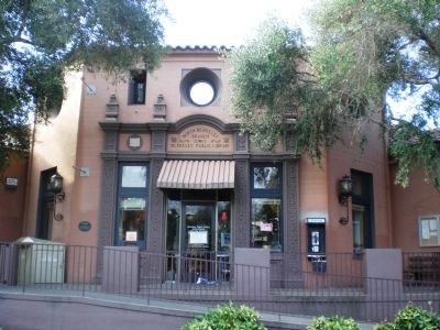
On The Alameda near Hopkins Street, on the right when traveling south.
City of Berkeley Landmark
Designated in 2001
North Branch Berkeley Public Library
James W. Plachek, Architect, 1936
North Branch Library is one of Berkeley’s many civic buildings by James Plachek, including the Central Library (1930), . . . — — Map (db m15868) HM
On Buena Vista Way, on the right when traveling east.
City of Berkeley Landmarks
designated in 1992
In one of Berkeley’s more eccentric experiments in living, Charles and Florence Boynton built their family residence as a version of a Greco-Roman temple with no walls. Two circular, open-air porches . . . — — Map (db m53864) HM
On Durant Avenue at Fulton Street, on the right when traveling east on Durant Avenue.
City of Berkeley Landmark
designated in 1983
This Zig-Zag Moderne building, designed for the sale and servicing of Buick automobiles, captures the glamour, rising affluence, and sophistication of the post-World War I era. Charles Howard, who . . . — — Map (db m54334) HM
On Shattuck Avenue at Addison Street, on the right when traveling south on Shattuck Avenue.
Samuel H. Kress began his chain of retail stores around 1900 and soon these “five and dime” variety stores dotted downtowns across America. Kress’s own company architects designed stores of high quality and adapted them to fit into the . . . — — Map (db m52380) HM
On Shattuck Square at University Avenue on Shattuck Square.
Shattuck Square is a group of three buildings constructed on the site of a former railroad freight yard, as a northern anchor to Berkeley’s historic downtown commercial district. It is the city’s only work by the San Francisco architectural firm . . . — — Map (db m52391) HM
Near Shattuck Avenue north of Bancroft Way, on the right when traveling north.
City of Berkeley Landmark
designated in 1984
John Tupper and Lawrence Reed constructed this building for their music store, which they had established in Berkeley in 1906. University of California art professor Eugen Neuhaus complimented them . . . — — Map (db m54507) HM
On Allston Way east of Milvia Street, on the right when traveling east.
City of Berkeley Landmark
designated in 1980
Berkeley’s elegant Main Post Office is representative of the Second Renaissance Revival style, also called Neo-Classical Revival. Government buildings constructed in this era were designed to . . . — — Map (db m54260) HM
City of Berkeley Landmark
designated in 2005
This corner store was built for Stella King’s dry goods business and upstairs residence. Until the shop closed in 1923, it was a gathering place where neighbors could find everything from sewing . . . — — Map (db m54722) HM
On Telegraph Avenue south of Dwight Way, on the right when traveling north.
Robert Agers constructed this building to manufacture "the very best soda water" for customers throughout California. The recessed storefronts, second-floor oriel windows, and high false front are all largely unchanged from a 1904 expansion. The . . . — — Map (db m29383) HM
On Rose Street west of Spruce Street, on the left when traveling west.
City of Berkeley Structure of Merit
designated in 1988
German immigrant George Hunrick built one of Berkeley’s many neighborhood groceries on this site when the north Berkeley hills were in an early stage of development. In those days before home . . . — — Map (db m54189) HM
On Hearst Avenue west of Ninth Street, on the right when traveling west.
No pivotal battles that changed the course
of history were fought here. Nary a famous
person was ever born or raised, lived, slept,
dined, or even gave a glancing look at this
place. This location did not provide a monumental role in the . . . — — Map (db m147452) HM
On Tenth Street south of Delaware Street, on the right when traveling south.
City of Berkeley Landmark
designated in 1979
Toward the end of the 19th-century, a large Finnish immigrant community was located in west Berkeley. Together they constructed this wooden building which integrates traditional Finnish and American . . . — — Map (db m53834) HM
On University Avenue east of Bonar Street, on the right when traveling east.
City of Berkeley Landmark
designated in 2001
During the early 20th century, the Santa Fe Railroad provided three-day passenger and freight service between Chicago and the Bay Area. This depot was one of three major rail stations in Berkeley. . . . — — Map (db m53828) HM
On Derby Street east of Sacramento Street, on the right when traveling west.
William C. Hays, Architect, 1922
James W. Plachek, Architect, 1930
John Reid, Jr., Architect, 1935
ELS/Elbasani & Logan Architects, 1998
As electric streetcar transportation improved and expanded in the early 20th-century, this section . . . — — Map (db m53873) HM
On Adeline Street south of Alcatraz Avenue, on the right when traveling south.
Hiram Lovell, Architect, 1910, 1914
James W. Plachek, Architect, 1921
The popularity of early movies created a demand for new spaces to accommodate eager audiences. South Berkeley’s first neighborhood theater with 144 stools for seats was . . . — — Map (db m53816) HM
On Adeline Street at Alcatraz Avenue, on the right when traveling south on Adeline Street.
City of Berkeley Landmark
designated in 1982
In the early 20th century, this was one of two banks anchoring the busy Lorin business district’s streetcar intersection. The building remained a bank until the 1980s. Its architecture combines a . . . — — Map (db m53815) HM
Near Shattuck Avenue north of Parker Street, on the right when traveling north.
Berkeley History
Horse-drawn wagons once carried goods to the Berkeley Free Market housed here. In 1952 the structure was modernized to accommodate automobile showrooms, with artist studios above. Richard Diebenkorn, Elmer Biscoff, William . . . — — Map (db m54333) HM
On Durant Avenue east of Ellsworth Street, on the right when traveling east.
The McCreary-Greer House and neighboring turn-of-the-century houses on this block are survivors of one of the first residential districts developed around the University campus. This house, with its original garden area and carriage house, . . . — — Map (db m52300) HM
On Grayson Street east of 7th Street, on the right when traveling west.
Berkeley History
Reflecting West Berkeley’s early industrial heritage, this plant remains one of the city’s largest brick buildings. Once used to produce chemicals for a cluster of nearby industries that manufactured soaps, cleaning agents, paper . . . — — Map (db m53812) HM
Near Donlon Way, on the right when traveling south.
This seven acre park is on the site of Dublin's original settlement that was established in 1850. Within the park are the 1856 Murray Schoolhouse, the 1859 St. Raymond Church, the 1880 Kolb Old House, the 1911 Kolb Craftsman Bungalow, the 1870 . . . — — Map (db m59946) HM
The Oldest Extant Catholic Church Building in Alameda and Contra Costa Counties
This land was donated as a Catholic site by Michael
Murray and Jeremiah Fallon, who was one of the
rescuers of the ill fated Donner Party in the Sierra.
Tom . . . — — Map (db m26701) HM
On Dublin Boulevard at Donlon Way, on the right when traveling west on Dublin Boulevard.
Built at the crossroads in 1862 by James Witt Dougherty where it served travelers going by stagecoach from Oakland to Stockton and from San Jose to Martinez and Sacramento. This area was named Dougherty Station from 1862 until 1878, and the hotel . . . — — Map (db m69726) HM
On Donlon Way at Dublin Boulevard, on the right when traveling north on Donlon Way.
Built in 1860 by John Green this building has been in constant use as a business building. It began as a general store, changed into a neighborhood pub, and now is a restaurant.
From 1914 – 1948 the northeast corner of the building was . . . — — Map (db m28578) HM
Near Ardenwood Boulevard near California Highway 84.
Joseph Silviera Leal and Julia Perry Leal built this tank house on their ranch in the Mission San Jose area of Fremont in 1925. The lower floor was a storage room and the upper floor a bedroom. The tank on top stored 5,000 gallons of water pumped . . . — — Map (db m29090) HM
On Mission Boulevard near Mission Tierra Place, on the right when traveling south.
With the discovery of gold in California, the town around the Mission San Jose became the gateway and provision center for the “49er” on his way to the Southern Mines.
To meet these demands, the firm of Strauss and Co. was founded by . . . — — Map (db m64904) HM
On Mission Boulevard at Washington Boulevard, on the right when traveling north on Mission Boulevard.
At the Ohlone Indian village of Oroysom, Padre Fermín Francisco de Lasuén founded this fourteenth of twenty-one Franciscan missions June 11, 1797. Taught by Padre Narciso Durán, the Ohlone Orchestra and Choir became famous. By 1830 almost 2,000 . . . — — Map (db m100551) HM
Thomas Jefferson Chadbourne and his wife Nettie built this Victorian carriage house in the 1870’s. He owned fine racing horses and stock horses and wanted them housed in suitable surroundings.
They purchased the property in 1872 from Charles C. . . . — — Map (db m28826) HM
On Wabana Common near Gable Drive, on the left when traveling south.
Henry Curtner arrived in Washington Township in 1852. A native of Fountain County, Indiana, Curtner became a prominent farmer, businessman, and philanthropist in the Warm Springs Area. Curtner’s ranch compromised several thousand acres and produced . . . — — Map (db m219704) HM
Near Hesperian Boulevard near Bookman Road, on the left when traveling south.
Built in 1886 for Neal and Sarah McConaghy, this 12 room Victorian farmhouse represents the beauty and elegance of a bygone era. Members of the family resided here until 1972. In response to community interest, Hayward Area Recreation District . . . — — Map (db m94565) HM
On Boston Road near Hampton Road, on the left when traveling north.
Built in 1869 by William Meek, a pioneer of commercial agriculture, the mansion is characteristic of the affluent agricultural society of the Victorian era in California.
The estate is on the site of the former Rancho San Lorenzo. This area . . . — — Map (db m149204) HM
On B Street at Mission Boulevard, on the right when traveling west on B Street.
This building replaces the two-story Palmtag Building, originally constructed by Leopold Palmtag in 1892. He settled in Hayward in 1860 and served as a town trustee. The building housed various businesses, including a radio station and a drug store. . . . — — Map (db m28907) HM
On First Street at S Livermore Avenue, on the right when traveling west on First Street.
This granite faced building was designed in the Classic Renaissance Revival Style for the Bank of Italy in 1921. It later became the thirteenth branch of the Bank of America. From 1957-1978, this building served as Livermore's city hall.
Listed on . . . — — Map (db m17878) HM
Livermore Public City Library
1911 to 1966
City of Livermore Historic Preservation Landmark Site
Dedicated July 1996
Operated by Livermore Area Recreation and Park DistrictNearby Rededication Plaque reads:
Andrew J. . . . — — Map (db m17754) HM
On Third Street, on the right when traveling east.
Built by by butcher Wm. E. Hinz and wife Rose for $1050. Purchased 1923 by Nienburgs and 1937 by Camillo Croce, vintner and brandy purveyor of Croce Winery, later the Livermore Winery. Remained in the Croce family until 2007. — — Map (db m199557) HM
On 2nd Street at S K Street, on the right when traveling west on 2nd Street.
Constructed with bricks salvaged from the Livermore Brewery, built 1874, destroyed by fire 1908
City of Livermore Historic Preservation Landmark Site Dedicated July 1996 — — Map (db m17870) HM
Fennon was a butcher. Levy was a tailor, saloon keeper and auctioneer. Both were prominent local business men.
Commemorated by the City of Livermore
Historic Preservation Commission
May 2008 — — Map (db m195149) HM
On South L Street, on the right when traveling north.
John H. Wilson was co-owner of the California Transfer Company, an important building materials distributor.
Commemorated by City of Livermore
Historic Preservation Commission
May 2007 — — Map (db m195143) HM
This railroad station having been located about half a mile west of the old town of Laddsville, on land owned by Wm. M. Mendenhall. Established the location of the town Livermore. The first depot was a freight car that was soon replaced by a . . . — — Map (db m194530) HM
On First Street at McCloud Street, on the right when traveling north on First Street.
[Upper Marker:]
Built 1875, this building was first a hotel then the Livermore Valley Bank. It was the Livermore Town Hall from 1905 to 1957. The jail was in the rear, and to the left the firehouse. It was here a light bulb was lit and . . . — — Map (db m19982) HM
On McLeod Street, on the right when traveling north.
Designed by prominent East Bay Architect,
Henry H. Meyers
Built by Pauly Jail Building Co. for $900
To prevent prisoner escapes,
this concrete building replaced
the existing wooden jail (1906-1922).
Original Town Hall and Firehouse . . . — — Map (db m194518) HM
On South L Street, on the right when traveling north.
Built by Oscar Meyers, a prominent local builder, in 1894, this home also became the Presbyterian Manse from 1905 to 1956.
Commemorated by City of Livermore Historic Preservation Commission
May 2007 — — Map (db m199562) HM
The Albertson brothers built this cottage and sold it in 1911 with the neighboring property to Steven Ferrario who operated a local saloon and restaurant and was cousin to local vintner, Enrico Ferrario. — — Map (db m199563) HM
On South L Street at 5th Street, on the right when traveling north on South L Street.
Donated to Alameda County by Livermore Post, American Legion
City of Livermore Historic Preservation Heritage Site
Dedicated July 1996
Operated by Livermore Area Recreation and Park District — — Map (db m17768) HM
On South L Street, on the right when traveling north.
W.A. Mitchell, co-owner of the California Transfer Company, built this home in 1908 and lived in it a short time. In 1928 it became home of Dr. Harms, retired director of Livermore Sanitarium.
Commemorated by City of Livermore
Historic . . . — — Map (db m195144) HM
On Mountain House Road, 0.5 miles south of Keho Road, on the right when traveling south.
Current site constructed 1923
Alameda County, California
For the purpose of providing
a continuation of essential
education and learning
Angelita Parlor No. 32, N.D.G.W, Livermore, California
Donner Parlor No. 193, N.D.G.W., Byron, . . . — — Map (db m92924) HM
On Niles Boulevard near J Street, on the right when traveling east.
This building was originally constructed as the Niles Branch of the Bank of Alameda County. Its doors opened on Monday, September 23, 1929. The construction was considered a “new modern building” that would be “a model of . . . — — Map (db m24455) HM
Within this crescent shaped valley is the beautiful 37-room Dunsmuir House, an example of colonial revival Victorian architecture. Built in 1899 on a 415 acre estate by Alexander Dunsmuir, heir to a Canadian coal and lumber fortune, for his bride . . . — — Map (db m72061) HM
On 12th Street near Oak Street, on the left when traveling east.
These five panels tell the stories of Alameda County's five courthouses.
Alameda County’s 1st Courthouse
Alvarado • 1853-1855
Alameda County’s first courthouse was a converted loft space above a general store in the frontier town . . . — — Map (db m72064) HM
On Jefferson Street at 11th Street, on the right when traveling south on Jefferson Street.
This marker, dedicated June 21, 2008, celebrates Chabot Space & Science Center's 125 years of inspiring Bay Area star gazers and curious minds of all ages.
From 1883-1915, an observatory on this site housed Chabot's first telescope, "Leah," an . . . — — Map (db m18875) HM
On Fourteenth Street at Martin Luther King, Jr. Way, on the left when traveling west on Fourteenth Street.
Dedicated in 1902 as the Oakland Public Library, this was the first Carnegie Library built in Oakland. Designed in the American Beaux Arts style by architects Bliss and Faville (who later designed the Hotel Oakland), it was Oakland's main library . . . — — Map (db m18670) HM
On Fourteenth Street at Castro Street, on the left on Fourteenth Street.
Designed in 1889 by Walter J. Mathews, this solid masonry Romanesque church departed radically from California's traditional Gothic wood frame construction. Noted for its world famous stained glass windows produced by Goodhue of Boston, and for . . . — — Map (db m100561) HM
Begun in 1911 and completed in 1914, this is Oakland’s fifth City Hall. Its construction was funded with a $1.15 million bond issue passed in 1909. The Beaux Arts design was by the New York firm of Palmer and Hornbostel, winners of a national . . . — — Map (db m72702) HM
On Thirteenth Street at Martin Luther King Jr. Way, on the right when traveling north on Thirteenth Street.
Oakland in the late 19th century was a thriving waterfront city, the second largest in the state. A center of commerce and industry, it was also known for advanced notions of civic improvement. Public schools and academies, convenient transit, and . . . — — Map (db m18771) HM
On 11th Street near Castro Street when traveling west.
Built in 1868 by Enoch H. Pardee (1827-96), physician, Mayor of Oakland, State Assemblyman, and Senator, it was the home of the families of E. H. Pardee and his son, George C. Pardee (1857- 1941), physician, Mayor of Oakland, Governor of . . . — — Map (db m71298) HM
Near Joaquin Miller Road near Sanborn Road, on the left when traveling east.
The tiny cottage known as “The Abbey” was built by the 19th century poet and environmentalist Joaquin Miller as part of a inspirational artists’ retreat. He purchased 70 grassy acres, parcel-by-parcel, in “The Hights” above . . . — — Map (db m71759) HM
The first known inhabitants of Fruitvale were the Ohlone. In 1820 the Spanish crown gave this land to Luis Peralta, making Peralta Hacienda the first non-native settlement in Oakland.
From 1820 to 1897, the family had a rancho at this site. . . . — — Map (db m28960) HM
Near Highland Avenue, on the right when traveling east.
On Saturday, May 5, 1898, a gala benefit for the Ladies’ Relief Society marked the opening of the Piedmont Springs Park by Frank C. Havens. Musicians played in a thatched bandstand while partygoers strolled through lighted pathways. Many guest dined . . . — — Map (db m72317) HM
On Magnolia Avenue near Highland Avenue, on the right when traveling east.
The Piedmont Springs Hotel was built by Walter Blair in 1872. The two-story white clapboard building had 20 bedrooms, two suites and five dining rooms, and the Grand Saloon. The 1887 cottages were added to increase capacity.
At 9:15 a.m. on . . . — — Map (db m72299) HM
Look carefully. Comparing today’s Japanese Tea House with early pictures, you will notice many differences. The first tea house in Piedmont Park was built by Frank C. Havens and opened on June 30, 1907. It was a replica of the late-fifteenth century . . . — — Map (db m72318) HM
Built in 1854, the Alviso Adobe is one of the few adobe structures remaining in the Bay Area. Declared a California Historic Landmark in 1954, the building stands relatively unmodified since the 1920s.
The adobe was in continuous use from 1854 . . . — — Map (db m24616) HM
John W. Kottinger (1819 – 1892) was Murray Township Justice of the Peace from 1853 to 1870. His home was the Seat of Justice for the township; The northwest corner of this adobe barn was used to jail prisoners. A frequent visitor was Joaquin . . . — — Map (db m24507) HM
Near Ray Street, on the right when traveling south.
John W. Kottinger one of pioneer founders and first Justice of the Peace of Pleasanton constructed this adobe brick barn about 1852. So built that part of it could house prisoners brought to justice in his court. Thus serving as Pleasanton’s first . . . — — Map (db m24592) HM
These low boundary walls show the approximate location of the Meadowlark Dairy manager’s house. The dairy manager played an important role in day-to-day operations. His house had a kitchen, living room, office and bedrooms. A half-cellar under the . . . — — Map (db m196198) HM
In 1864, five years before the first railroad arrived in Pleasanton, John W. Kottinger demonstrated his faith in Pleasanton”s future by building the communities first hotel, The Farmer’s Hotel.
The building was purchased by Henry in 1891 and . . . — — Map (db m24607) HM
On Lafayette Avenue near Leo Avenue, on the right when traveling north.
This house was built by William Toler for his father-in-law Ygnacio Peralta. It may be the first brick house in Alameda County. Peralta and his brothers established the first Spanish/Mexican settlements in the northern East Bay on the land grant . . . — — Map (db m26471) HM
Near Lafayette Avenue near Leo Avenue, on the right when traveling south.
First brick house built in Alameda County. Constructed 1860 by W. R. Toler for Ignacio Peralta, early San Leandro Spanish settler, whose father, Don Luis Maria Peralta, received land grant from Spanish Governor Don Pablo Vicente de Sola, October 20, . . . — — Map (db m100550) HM
On West Estudillo Avenue at Clarke Street, on the right when traveling west on West Estudillo Avenue.
Three descendants of land grant recipient Luís Maria Peralta lived in this home. In 1926, Herminia Peralta Dargie (pictured above) remodeled the home in the style of a Spanish villa. Tiles depict the story of Don Quixote, and adobe bricks saved from . . . — — Map (db m26398) HM
On East 14th Street (California Route 185) at Estudillo Avenue, on the left when traveling south on East 14th Street.
The Best Building is a significant example of commercial architecture in San Leandro and the only San Leandro Plaza building remaining from the early decades of the 20th century. As a manufacturer and inventor, Daniel Best had already contributed . . . — — Map (db m54740) HM
This building was originally the Sunday School Annex of the First Presbyterian Church of San Leandro. Built in 1867 and located on Clarke Street. The main church was moved to Ashland and later torn down. This annex was saved by the Historical . . . — — Map (db m26396) HM
This building has been the pioneer home of the Kirkwood and Taylor families since it was built by Zachary Kirkwood in 1864. This building was one of the first resorts operated in the Sierra Nevada Mountains. — — Map (db m100580) HM
The construction of this historical complex was initiated in 1964, "Alpine County's Centennial Year", by the Historical Society of Alpine County. With concerted effort and fortitude it was completed and duly dedicated as a historical landmark on . . . — — Map (db m3088) HM
On State Highway 4/89 at Montgomery Street, on the right when traveling south on State Highway 4/89.
Originally built in 1862 as the Fiske House in Silver Mountain City. It was dismantled, board by board, in 1886 by A.M. Grover and a crew of men. Each board was marked and many of the old square nails were saved. It was re-erected on this site and . . . — — Map (db m20631) HM
On August 2, 1885, fire broke out in the Town of Markleeville destroying several buildings, including Harvey and Rask’s Bucher Shop and Smokehouse. Later on in the Fall, the building was rebuilt and reopened as Rask’s Butcher Shop.
The building . . . — — Map (db m11963) HM
In 1875, the Alpine County seat was moved from Silver Mountain (Kongsberg) to Markleeville. A new jail being needed, a foundation was laid using logs. The iron cells from the old jail were placed thereon and using the mortise and tenon method the . . . — — Map (db m3007) HM
Built by the citizens of Markleeville in 1882 it remained in operation until 1929 when the new Webster School was completed. In 1966, with the old school on the verge of total destruction, the Historical Society of Alpine County began to raise funds . . . — — Map (db m3006) HM
On Main Street (Old State Highway 49) at Water Street, on the left when traveling south on Main Street.
Present two story brick structure was completed in 1879. Designed as a mercantile store, then converted to hotel and boarding house to accommodate local miners and travelers. Remained in operation until 1927. Walls at the base are twelve bricks . . . — — Map (db m9005) HM
On Buena Vista Road at Jackson Valley Road. on Buena Vista Road.
In the mineral rich Ione Valley, between Ione and the southern Mokelumne River, where once mining communities like, Lancha Plana, Camp Opra and Camanche dotted the maps, is the town of Buena Vista. Situated at the intersections of two thoroughfares . . . — — Map (db m101437) HM
On Buena Vista Road at Jackson Valley Road on Buena Vista Road.
Buena Vista's store and house situated in Jackson Valley, was built by John Fitzsimmons, then sold to Sam Cook, then to James Norris and afterwards to Jacob and Verona Strohm. Once situated in Lancha Plana it was moved by the Chinese who discovered . . . — — Map (db m10189) HM
On East Main Street, on the right when traveling west.
General merchandise store built by Daniel Stewart in 1856. First brick building erected in Ione Valley from nearby Muletown brick. Ione, once known as "Bed-Bug" and "Freeze-Out” was an important supply center on the main road to the Mother Lode and . . . — — Map (db m100587) HM
On Preston Avenue (California Route 104) at Welch Lane, on the right when traveling north on Preston Avenue.
Built in the 1860’s of Ione Brick by Brewers Raab and Huttner. Served as a Brewery for Over 30 Years. In 1907 C.C. Prouty Moved His Creamery to this Site. A Soda Works and Ice Plant Were Installed in 1910. Various Businesses Have Occupied the . . . — — Map (db m15825) HM
On East Main Street at North Church Street, on the left when traveling west on East Main Street.
Originally built as the three story commercial hotel in 1864, razed by fire and re-built as a one story building in 1930. Remodeled in 1966 by the City of Ione as its City Hall.
Mayor
David S. Mason III
Councilmen
Jack Gasawawy • . . . — — Map (db m2373) HM
On East Main Street, on the left when traveling west.
This building, built in the year of 1854, was originally a hardware store on the ground floor and a dance hall on the upper floor.
Ione Parlor No. 33, N.S.G.W. bought the building in the year 1884 and has continuously owned it and met here . . . — — Map (db m2380) HM
Built circa 1863, this imposing residence with its classical columns, two-storied gallery, French window and fan transom, is an important local representative of the Greek Revival tradition in America. The house, constructed of locally fired brick, . . . — — Map (db m94748) HM
Near Church Street near North Street, on the right when traveling south.
Home (built 1859) of Armstead C. Brown (1816 – 1902) & son George until 1947. A.C. Brown was a lawyer, first president of Jackson City Trustees, state assemblyman 1863 – 66 & 1860 – 70, county judge 1876 – 78. Gave land to . . . — — Map (db m27683) HM
On State Highway 49 at milepost 1.4,, 2.5 miles south of State Route 88, on the left when traveling south.
Constructed by Italian stone mason in 1857. Served pioneer settlers and miners as post office and general store later later known as Ginocchio's. — — Map (db m100579) HM
1340 entries matched your criteria. The first 100 are listed above. Next 100 ⊳