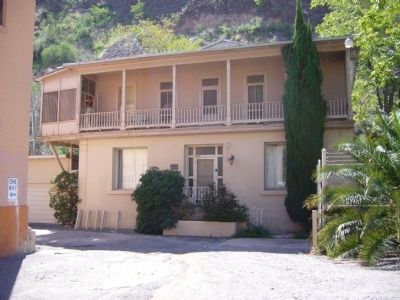
Clifton Historic District
Fermin Palicio Home
Built in 1917
Has been placed on the
National Register
of Historic Places
By the United States
Department of the Interior — — Map (db m36250) HM
Anderson Building, 1914
Chandler Historic Commercial District on the National Register of Historic Places
Built by local Chandler rancher and early business investor John Anderson, this structure was home to Curry and Frye's Pool Hall, . . . — — Map (db m72037) HM
Bank of Chandler, 1912Dr. A. J. Chandler built the original structure on this site to serve as the main office for his Chandler Improvement Company. The Bank of Chandler shared this building until 1925. Bogle Farms and other offices operated . . . — — Map (db m71000) HM
Dougherty Building, 1914
Chandler Historic Commercial District on the National Register of Historic Places
This building, constructed by Michael F. Dougherty, has been home to a number of businesses, including the Charles Karp Clothing . . . — — Map (db m71008) HM
Hotel Chandler, 1914
Chandler Historic Commercial District on the National Register of Historic Places
The second story of this building was the Hotel Chandler, an affordable alternative to the luxurious San Marcos Hotel. Starting in 1917, . . . — — Map (db m72133) HM
Monroe Building, 1912
Chandler Historic Business District on the National Register of Historic Places
Built by the Chandler Improvement Company, this building is named for merchant M. E. Monroe, who opened the Monroe Hardware Store in the . . . — — Map (db m71001) HM
Morrison Grocery, 1912
Chandler Historic Business District on the National Register of Historic Places
Ernest and Leroy Morrison opened the Chandler’s first grocery here in 1912. The building has been host to a series of grocery stores, the . . . — — Map (db m71003) HM
Suhwaro Hotel, 1916
Listed on the National Register of Historic Places
This Spanish Mission Revival building had many uses, including a hotel, school and bowling alley. The San Marcos Hotel purchased the Suhwaro Hotel in 1924 for staff . . . — — Map (db m49867) HM
This building was originally the Creed Store. The 1923 picture below is of Raymond R. Creed who served as the Mayor of Gilbert in 1925. Ethel Hoffman Lacy, shown in the center of the photo, was the postmaster at this time. Winnie Johnson, wife of . . . — — Map (db m88070) HM
The Gilbert town hall was built in 1938 to serve the area's 1400 residents. This building consisted of a fire station with a jail behind it. The courthouse and council chambers were also in the building. On January 2, 1938, Congress approved the . . . — — Map (db m88082) HM
In 1925 the well for Gilbert’s domestic water was drilled to the depth of 475 feet where a large flow of pure water was found. A six-inch pipe was sunk to bring the water to the surface. The tower and pumping station were constructed during the . . . — — Map (db m90238) HM
The Bank of Gilbert was built in 1917. One of the men instrumental in the creation of the bank was Abe Cosby (pictured below on right) who came to Gilbert to invest in land and open a real estate office. Bill Andersen, (shown of left) one of the . . . — — Map (db m88069) HM
This house, which is the oldest building at Sahuaro Ranch, is believed to have been built in 1887, one year after William Bartlett started the ranch. It was constructed of adobe bricks made here at the ranch, possibly using dirt that was excavated . . . — — Map (db m40639) HM
On November 14, 1940, Tom Coury signed an agreement with building contractor, H. D. McNeely, and the Glendale Lumber Company to construct a 42' x 65' brick building at a cost of $3,911. Upon completion of the building, Smart and Final Wholesale . . . — — Map (db m30439) HM
Built sometime around the turn of the 20th century, this house was the last residence to be constructed at Sahuaro Ranch.
Little is known about who lived in the house, but it appears to have been built as a residence for the employees of William . . . — — Map (db m40688) HM
This property is listed in the
National Register
of Historic Places
By the United States Department of the Interior
Listed July 7, 1989
In 1901, a small group of pioneer women organized the Self Culture Club of Glendale with the . . . — — Map (db m30478) HM
Mrs. Alice S. Hine, an agent for the Phoenix Title and Trust Company, hired a contractor by the name of Home Builders Company to build the two-story masonry structure in 1913. In 1919, Mrs. Hine added a substantial addition to the building along . . . — — Map (db m30435) HM
Brethren businessmen S. Humphrey and A. Davidson, the largest agricultural shipping agents in the area, built this single-story brick commercial building to house their dry goods business. This building shifted Glendale's commercial focus from the . . . — — Map (db m30437) HM
The large house to the right, now known as the Main House, was the home of the superintendent who managed Sahuaro Ranch for its owner, William Bartlett. The oldest section, on the right, was built in 1891 as an office. In 1895 it was expanded and . . . — — Map (db m40622) HM
Robert W. Cole bought three lots on the east side of the park in 1919. He hired J. C. Howell, a local architect to design the two-story building, and Robert Fultz was the builder. Construction started in June of 1919, and finished in September of . . . — — Map (db m30434) HM
"The residence on the Ranch is not a characteristic Arizona farm houses, as it contains thirteen bedrooms, eight of which are equipped with baths. The house rambles over considerable territory and, in the summer, the lawn is a wonder of . . . — — Map (db m40636) HM
This property is listed in the
National Register
of Historic Places
By the United States Department of the Interior
Listed January 11, 2006
Cullin H. Tinker, prominent banker, and mayor from 1916 to 1922 built the house in 1913, . . . — — Map (db m30480) HM
The Maricopa County Courthouse was originally built in 1928-1929 by both Maricopa County and the City of Phoenix. The County Courthouse portion of the building was designed by a Louisiana architect. Edward F. Neild. The City chose the Phoenix firm . . . — — Map (db m73077) HM
Known as the Odd Fellows Hall when it was built in 1898, this building is the oldest surviving three story brick commercial building in Maricopa County. Its 2-story high ballroom, located on the second floor, has hosted several fraternal . . . — — Map (db m49913) HM
Moderne Style Structure Only Lamella Roof in Kingman Art Deco Detailing
National Register of Historic Places Plaque Donated by Heritage Crossroads 2003 — — Map (db m185213) HM
This building has been placed on
The National Register of
Historic Places
By the United States Department of the Interior
St. John’s
United Methodist Church
Built 1917
Constructed of locally quarried tufa stone, this is the . . . — — Map (db m29408) HM
This building has been placed on
The National Register of
Historic Places
By the United States Department of the Interior.
U.S. Post Office
Built 1935
A monument to massive federal building programs during the 1930's, . . . — — Map (db m29409) HM
The Big House, built before 1875, has been placed on the National Register of Historic Places by the United States Department of the Interior. — — Map (db m274935) HM
This property has
been placed on the
National Registry of
Historic places of the
U.S. Dept. of Interior.
(Formally
Oatman Drug and
Health Club) — — Map (db m29465) HM
Did you notice where the trail passed over the faint outlines of the rooms? Over 100 rooms formed a one-story apartment complex surrounding a central plaza in the village. The building materials for the pueblo were blocks of native sandstone, shaped . . . — — Map (db m68887) HM
The village on the Rio Puerco (Puerco Pueblo) is a prehistoric settlement built of shaped sandstone blocks by ancestral Puebloan people. It was inhabited between A.D. 1250 and 1380. At its peak the pueblo had over 100 rooms, with a possible . . . — — Map (db m68881) HM
La Posada was the last of the great Fred Harvey/Santa Fe Railway hotels.
This is the masterpiece of Mary Jane Colter, considered by many to be the greatest of all Southwestern architects.
La Posada is on the National and State Registers of . . . — — Map (db m32787) HM
This house dating from the 1870s was purchased by Carlos and Beatriz Velasco in 1878. In the same year, Velasco began publication of the newspaper "El Fronterizo," which continued until his death in 1914. This building was the office and . . . — — Map (db m150194) HM
Façade restoration
44 North Stone Avenue
Original Architect - Roy Place (1887-1950)
Rededicated September 2010
Pima County 2004 Bond Funds
Façade restored to original 1929
design and appearance
Pima County Board of Supervisors
Ann . . . — — Map (db m84246) HM
This Property
is Listed in the
National Register
of Historic Places
By the United States Department of the Interior
St. Philip's in the Hills
1936 — — Map (db m31524) HM
This adobe building, which was designed by Levi Ruggles and built in 1878, combines Sonoran and Anglo-American architectural features typical of Territorial Arizona. It was the courthouse until 1891 and then served as a hospital, health center, home . . . — — Map (db m269160) HM
Several Tubac churches have stood on this site. The first, a shelter built by Jesuit missionaries in the early 1700's, was administered from Tumacacori. About 1760 Captain De Anza built a chapel for presidio soldiers. A later church was visited by . . . — — Map (db m27143) HM
In 1789, Toribio Otero received the first land grant in this area in exchange for teaching school at his ranch. A school district was established in 1876 and in 1885 T. Lillie Mercer built this school, one of the earliest in Arizona. It was in use . . . — — Map (db m27142) HM
Built circa 1926-27
by the Arizona Department
of Transportation
This building constructed of Moenkopi Sandstone, has been listed on the National Register of Historic Places.
The Ash Fork Camp location was selected because it is a . . . — — Map (db m33443) HM
The original Jerome Town Hall was built in the late 1800s. The town quickly outgrew the small space and by 1929 a bond had passed to enlarge the old brick building. New construction was to be of concrete. In addition to enlarging town hall, a police . . . — — Map (db m33145) HM
You are standing at the second story entrance to what once was a three story primary school. The land was purchased, a bond was passed and construction began in 1913. It opened May 29, 1914 to graduate 3 seniors: Francis Lyons, Gertrude Rothermel . . . — — Map (db m33191) HM
The mine museum, one of Jerome's oldest commercial buildings, was purchased by J.S. Hoover and A.C. Cordiner from G.A. Stoney in 1896. The building was destroyed in a fire in 1898. An architect from Los Angles built the present building with steel . . . — — Map (db m33157) HM
This one-half story wood frame structure with corrugated sheet metal was built in the 1920's. It was the Reese and Amster White Garage and Machine Shop. Vehicles sold by Reese and Amster included the Chrysler 50, 60 and 70 and the Maxwell Car, which . . . — — Map (db m33150) HM
Built in 1917, the first floor of this four-story apartment, housed the Independent Meat Company. A passage was built from the cooler of the meat company up to the apartments to allow cool air to pass into them. Originally there were nine . . . — — Map (db m33190) HM
In 1896, one of the first wooden structures built in Jerome occupied this site and was known as "The Saloon". The Saloon building survived two years before succumbing to fire, which destroyed most of Jerome in 1898. The structure was rebuilt only to . . . — — Map (db m33165) HM
This Romanesque/Classical Revival building was constructed in 1895 and served as both a fire station (on the first floor) and the City jail (on the second). It is one of the two buildings facing the Courthouse Plaza that survived the fire of 1900. . . . — — Map (db m33090) HM
In early 1908, the Prescott School Board decided that a new school was needed in Prescott. On July 12, 1908, a school bond election was held and approved by the voters 119-1. In August 1908, the three acre site on Park Avenue on the west side of . . . — — Map (db m33049) HM
Prescott's modern public library was dedicated on May 18, 1975. However, the history of a public library in Prescott goes back to August 1895, when seven local ladies founded the Women's Club of Prescott (now the Monday Club). They gathered a . . . — — Map (db m52912) HM
George W. Curtis came to Prescott from California in 1864, and in 1867 purchased an interest in a sawmill. He purchased a building on Granite Creek on South McCormick Street, and he and his brother John enlarged and modified the building in 1878. . . . — — Map (db m33062) HM
The southeast corner of Goodwin and Cortez Street was the site of Howey's Hall, which was built on the first lot sold (for $175) in Prescott by James Howey in 1876. The Goldwaters had their first mercantile store here. It was later converted to an . . . — — Map (db m33092) HM
Joseph and Margaret Ehle arrived in Prescott, Arizona Territory, on July 13, 1864 with their children, John Henry, Mary Jane, Amy E., Olive Joan, Sarah F. and Margaret Viola. Mr. Ehle helped to build the log Governor's Mansion (now part of Sharlot . . . — — Map (db m33133) HM
Jacob Wolf was a merchant, builder of log structures,
carpenter, and blacksmith. He was elected a
representative to Arkansas Territory's General
Assembly in 1826. The two-story dogtrot structure
constructed by Wolf in 1829 served as Izard . . . — — Map (db m170758) HM
This native stone tank was built in 1927 by the Linebarger brothers, under the supervision of Willard Braithwaite, to store water for summer cottages on the west side of Lake Bella Vista and later the Sunset Hotel. From 1927 to 1952, water from the . . . — — Map (db m224956) HM
This site
When the Clark County seat was
moved from Greenville to Arkadelphia
in 1842, until completion of a permanent
structure in 1844, a log building
which stood here served as court
house.
In 1860 a handsome two-story
brick . . . — — Map (db m234844) HM
Here, during Reconstruction years, were the offices of the Freedmen's Bureau. The building was, at different times, used as a harness shop, grocery store, barber shop and saloon, and for many years was a residence. — — Map (db m234853) HM
The Ott family of Parkin purchased the
Northern Ohio School from the Kelly family in
1959. The Kellys had been using the school
for a hay barn. The Ott family transformed
the old "barn" into a home by portioning
rooms and designing a living . . . — — Map (db m221318) HM
The X.O. Pindall Law Office was built
Circa 1882 and is on the National Register of Historic Places.
The law office of the former Arkansas Governor was given to the
University of Arkansas at Monticello by Robert and Beverly Moore on December 13, . . . — — Map (db m299918) HM
Constructed in 1904 as one of
the first office buildings
built to house the growing demand
for doctors offices and drug
stores. Remodeled as Wheatley
Hotel in mid 1950's. Bowling
alley in basement. — — Map (db m211128) HM
Organized on May 5, 1883 under a brush arbor across a creek behind the present day structure under the Leadership of Rev. B.B. Dilloney This Property has been Placed on the Arkansas Historic Preservation of Historic Places December 4, 2013 . . . — — Map (db m264600) HM
Construction projects undertaken during the 1920s and 1930s produced Hot Springs' most imposing structures. One of these, the completion of the Medical Arts Building, gave Hot Springs the distinction of having Arkansas' tallest building for several . . . — — Map (db m211053) HM
Tarleton-Wall House, 812 Quapaw Avenue, has been placed on the National Register of Historic Places by the United States Department of the Interior. 1907 — — Map (db m304000) HM
The Malco Theatre was built in 1946 in the 800 block of Central Avenue, on the site of the Princess Theatre which burned on Christmas Eve, 1935. The Malco had one screen as well as a small stage for vaudeville acts. Today, it is home to the Hot . . . — — Map (db m264287) HM
Along this hillside was the location of the
Park Superintendent's residence. Overlooking
Fountain Street, the house was built in 1891 at
the request of Park Superintendent Frank
Thompson to replace a small four-room
wooden structure built by . . . — — Map (db m297080) HM
"In this house I learned to walk and talk. I learned to pray I learned to read and I learned to count by number cards my grandparents tacked on the kitchen window."
— President Clinton, Dedication Speech at
the . . . — — Map (db m161922) HM
Bill Clinton lived in this
house with his mother and
stepfather, Roger Clinton, from
1950 until 1953. During those
years, the future president
attended kindergarten and first
grade. Billy, as he was known
then, loved to play with . . . — — Map (db m159746) HM
The original structure was built in the year of 1893 and originally stood on a lot due south of the present location. Mr. and Mrs. Jacob Boyle bought the house in 1899 where they live and reared eleven children. In 1903 the Boyle family remodeled . . . — — Map (db m227629) HM
This building was constructed in 1904 by the federal government for the U.S. Post Office and the Batesville division of federal court for the Eastern District of Arkansas and was in use by federal agencies until 1974 when a new building was built a . . . — — Map (db m70558) HM
Site of first Court House of Izard
County. A small building of rough logs,
erected at Liberty in 1830. It stands in
what is now Baxter County. The second
court house was a frame building erected.
in 1834. The third was built at Mt. Olive
in . . . — — Map (db m170362) HM
Jacksonport became the county seat in 1853. Delayed by the Civil War, courthouse construction was not begun until 1869. It was completed in 1872.
When the county seat was moved to Newport in 1892, this building became a school, a cotton gin, the . . . — — Map (db m221217) HM
In 1818 a French trapper, Joseph Bonne landed on the south bank of the Arkansas River with his dog and gun near the location of the original Jefferson County Courthouse. Driven to this high bluff after flood waters had threatened his homesite at . . . — — Map (db m30576) HM
This property has been placed on the National Register of Historic Places by the United States Department of the Interior Owners Joe Mason Sr Peggy Mason — — Map (db m238098) HM
This property has been placed on the National Register of Historic Places by the United States Department of the Interior Owner Elizabeth Pickens — — Map (db m238097) HM
This property has been placed on the National Register of Historic Places by the United States Department of the Interior Owner: Gene Yarbrough Family — — Map (db m238096) HM
In the fall of 1851, three Mills brothers
headed west, one by water, one by land and
one to Texas. This brought Joel Mills wife,
Kitura Burke Bird and family from Henderson Co., Tennessee to Sevier County, now known as Little River County. . . . — — Map (db m121361) HM
A variety of colony services were housed in the original building on this site. When it burned in 1944, the theater and pop shop took its place. — — Map (db m207512) HM
Also called the Co-op Store, Trading Post, or The Big Store, this building carried everything colonist families needed. It burned in June 1957. — — Map (db m207494) HM
Built in 1909, the Bank of Osceola shared this building with various enterprises over the years, including a cotton brokerage firm and small movie theater. While much of the original architecture remains intact, four circular stone profiles of . . . — — Map (db m36670) HM
Built in 1915, the ground floor of this building once housed a barber shop and, later a hardware store. J.T. Coston, a Vanderbilt-educated attorney representing R.E.L. Wilson's farming interests, maintained his offices upstairs and was instrumental . . . — — Map (db m36453) HM
This corner building has been home to a drug store dating back to 1913. Once a two-story building with an elevated parapet and cornice, a fire in the early 1960s destroyed the second floor. The building's longest-running occupant is Newcomb's Drug . . . — — Map (db m36669) HM
14263 entries matched your criteria. Entries 301 through 400 are listed above. ⊲ Previous 100 — Next 100 ⊳