By David J Gaines, October 5, 2013
Lauderdale County High School 1912 Marker (side 2)
| On College Street at Williams Street, on the left when traveling east on College Street. |
| On Alabama Route 101 at County Route 646, on the right when traveling north on State Route 101. |
| On Court Street (County Route 460) at Hospital Street, on the right when traveling west on Court Street. |
| On Market Street (Alabama Route 33) at College Street, on the right when traveling south on Market Street. |
| On Rosenwald Street south of Taylor Street, on the right when traveling south. |
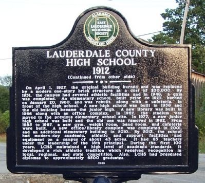
| On East Magnolia Avenue, 0.1 miles east of North College Street (Alabama Route 15), on the right when traveling west. |
| On East Magnolia Avenue at South Gay Street, on the right when traveling east on East Magnolia Avenue. |
| On West Thach Avenue at Mell Street, on the right on West Thach Avenue. |
| On Donahue Drive, 0.3 miles south of West Samford Drive, on the right when traveling south. |
| On South College Street north of East Thach Avenue, on the right when traveling north. |
| On West Thach Concourse, 0.1 miles west of Miller Drive, on the right when traveling west. |
| On Tichenor Avenue at North Gay Street, on the right when traveling east on Tichenor Avenue. |
| Near West Thach Road at South College Street. |
| Near Garden Drive, 0.1 miles west of South College Street (Alabama Route 15), on the left when traveling west. |
| On Spencer Avenue, 0.1 miles north of Clark Avenue, on the right when traveling north. |
| Near War Eagle Way at South Donahue Street, on the left when traveling west. |
| On Shelton Mill Road (County Route 97) 0.8 miles north of East University Drive, on the left when traveling north. |
| On East Magnolia Avenue, 0.1 miles east of Burton Street, on the left when traveling east. |
| On Mitcham Avenue at North Gay Street, on the right when traveling west on Mitcham Avenue. |
| Near Woodfield Drive, 0.1 miles east of South College Street (Alabama Route 15), on the right when traveling east. |
| Near South College Street north of West Thach Avenue, on the right when traveling south. |
| On Lem Morrison Drive, 0.1 miles north of Duncan Drive, on the right when traveling north. |
| On South Gay Street at East Thach Avenue, on the right when traveling north on South Gay Street. Reported missing. |
| On Stage Road (Alabama Route 14) 0.4 miles east of Arrowhead Road (County Road 188), on the right when traveling east. |
| On Long Street at Auburn Street, on the left when traveling north on Long Street. |
| On Avenue B at South 9th Street, on the right when traveling south on Avenue B. |
| On Pryor Street close to N. Beaty Street, on the right when traveling east. |
| On Beaty Street North at Market Street/Buck Island Road on Beaty Street North. |
| On 4th Street at Grace Avenue, on the right when traveling west on 4th Street. |
| On Market Street east of North Marion Street, on the right when traveling west. |
| On Browns Ferry Street (County Road 29) west of Allyn Street, on the right when traveling west. |
| On East Washington Street west of East Street, on the right when traveling west. |
| On Trinity Circle north of Browns Ferry Street (County Road 29), on the left when traveling north. |
| On Trinity Circle north of Browns Ferry Street (County Road 29), on the left when traveling west. |
| Near East Market Street west of South Clinton Street, on the right when traveling east. |
| Near Bee Line Highway (U.S. 31) 0.6 miles south of Thomas L Hammons Road, on the left when traveling south. |
| On Upper Fort Hampton Road (County Route 49) east of Railroad Street, on the left when traveling east. |
| On Upper Fort Hampton Road (County Road 49) east of Railroad Street, on the left when traveling east. |
| Near Lauderdale Street west of East Street (County Road 71), on the right when traveling west. |
| Near Lauderdale Street west of East Street (County Road 71), on the right when traveling west. |
| On Howard Lane, 0.1 miles South Broad Street (County Road 29), on the left when traveling east. |
| On Tuskegee-Franklin Road (Alabama Route 49) 0.4 miles south of County Road 17, on the left when traveling south. |
| Near Tuskegee Street (Alabama Route 81) at Shiloh Street, on the right when traveling north. |
| On Tuskegee Street (Alabama Route 81) at Shiloh Road, on the right when traveling north on Tuskegee Street. |
| On Old Federal Road (County Road 8), on the right when traveling west. |
| On North Church Street at West Martin Luther King Highway (U.S. 80), on the left when traveling north on North Church Street. |
| On Westside Street at West Northside Street, on the right when traveling south on Westside Street. |
| On County Road 27 north of County Road 36, on the right when traveling north. |
| On South Main Street at West Price Street, on the left when traveling north on South Main Street. |
| On West Montgomery Road east of Chambliss Street, on the right when traveling east. |
| On South Main Street (U.S. 29) at East Price Street, on the right when traveling north on South Main Street. |
| On Lewis Adams Street at University Avenue, on the left when traveling south on Lewis Adams Street. |
| Near Booker T Washington Boulevard at Campus Drive. |
| On University Avenue at Lewis Adams Street, on the right when traveling east on University Avenue. |
| Near University Avenue, 0.2 miles east of Booker T. Washington Boulevard. |
| On Booker T Washington Boulevard at Campus Drive, on the right when traveling north on Booker T Washington Boulevard. |
| On Booker T. Washington Boulevard at Benjamin F Payton Drive on Booker T. Washington Boulevard. |
| Near University Avenue, 0.2 miles east of Booker T. Washington Boulevard. |
| On University Avenue, 0.2 miles east of Booker T. Washington Boulevard, on the right when traveling east. |
| On University Avenue, 0.2 miles east of Booker T. Washington Boulevard, on the right when traveling west. |
| Near University Avenue, 0.2 miles east of Booker T. Washington Boulevard. |
| On NW Chambliss Street south of West Montgomery Road, on the left when traveling south. |
| On Moton Drive at Booker T. Washington Boulevard on Moton Drive. |
| On Booker T Washington Boulevard at Campus Road on Booker T Washington Boulevard. |
| On University Avenue, 0.2 miles east of Booker T. Washington Boulevard, on the right when traveling east. |
| On University Avenue west of Tuskegee Airmen Circle, on the right when traveling west. |
| On University Avenue at Lewis Adams Street, on the right when traveling west on University Avenue. |
| On University Avenue at Tuskegee Airmen Circle, on the right when traveling north on University Avenue. |
| On Campus Road east of Foster [West Outer] Drive, on the right when traveling east. |
| On University Avenue east of Booker T Washington Boulevard, on the right when traveling east. |
| On Foster Drive at Moton Drive, on the right when traveling south on Foster Drive. |
| On University Avenue west of Lewis Adams Street, on the right when traveling east. |
| On Booker T Washington Boulevard, 0.1 miles south of Frederick D. Patterson Drive, on the right when traveling south. |
| On University Avenue at Foster Drive, on the right when traveling east on University Avenue. |
| On University Avenue at Tuskegee Airmen Circle, on the right when traveling east on University Avenue. |
| Near University Avenue, 0.2 miles east of Booker T. Washington Boulevard. |
| On Lee Highway/John T Reid Parkway (U.S. 72) at Gurley Pike, on the right when traveling west on Lee Highway/John T Reid Parkway. |
| On Gates Avenue at Franklin Street S.E. on Gates Avenue. |
| On Oakwood Avenue Northeast at Lee High Drive Northeast, on the right when traveling west on Oakwood Avenue Northeast. |
| On Gallatin Street Southwest at Governors Drive Southwest, on the right when traveling south on Gallatin Street Southwest. |
| On Ward Avenue NE at White Street NE, on the left when traveling east on Ward Avenue NE. |
| On Randolph Avenue Southeast west of Calhoun Street Southeast, on the right when traveling east. |
| On Meridian Street at Abingdon Avenue NW, on the right when traveling north on Meridian Street. |
| On Triana Boulevard SW, 0.3 miles north of Drake Avenue SW, on the right when traveling north. |
| On Monte Sano Boulevard Southeast, on the right when traveling north. |
| On Southeast Cooper Street at Lookout Drive Southeast, on the left when traveling north on Southeast Cooper Street. |
| On Adventist Blvd NW at Millennium Drive NW, on the right when traveling north on Adventist Blvd NW. |
| On Adventist Blvd NW, 0.2 miles west of Sparkman Drive NW, on the right when traveling west. |
| On Clinton Avenue SE at Monroe Street SE, on the right when traveling east on Clinton Avenue SE. |
| On Randolph Avenue Southeast, on the right when traveling east. |
| On Church Street Northwest, on the right when traveling north. |
| On Clinton Avenue East, on the right when traveling west. |
| On Randolph Avenue SE west of Figures Alley SE, on the right when traveling west. |
| On Beasley Avenue Northwest at Magnolia Drive Northwest, on the right when traveling west on Beasley Avenue Northwest. |
| Near Bob Wallace Avenue Southwest. |
| On Monroe Street at Williams Avenue, on the right when traveling south on Monroe Street. |
| On St. Clair Avenue, 0.1 miles east of Monroe Street, on the right when traveling west. |
| On Poplar Ridge Road north of Hodges Road, on the left when traveling north. |
15324 entries matched your criteria. Entries 201 through 300 are listed above.
⊲ Previous 100 —
Next 100 ⊳