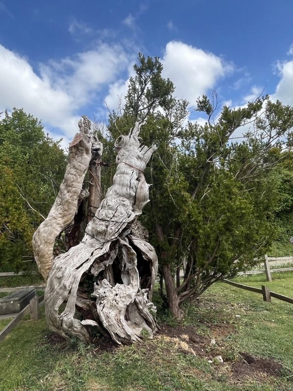
Near Townsend Road, on the right when traveling north.
Quite possibly the yew's antecedents were witness to pagan worship long before Christianity arrived in Britain.
The size and age of this tree has certainly been a subject of wonder and discussion for centuries.
The trunk diameter was . . . — — Map (db m311870) HM
In memory of the men of Bracknell and District who gave their lives for King and Country in the Great War 1914 - 1919
"Greater Love Hath No Man Than This"
-
And in the World War 1939-1945
-
Saith the Angel
"These are they that have . . . — — Map (db m245678) WM
Between 200 BC and 40 AD: 'Caesar's Camp' hillfort built by the Celts.
10th Century: 'Braccan Heal' first mentioned, in an Anglo-Saxon charter
1463 Old Bracknell mentioned in a Goring charter.
1607 Norden's map of Windsor Forest shows . . . — — Map (db m217585) HM
It was originally believed that Lily Hill House was built sometime between 1849 and the early 1850s as 'a moderately sized gentleman's residence’.
However letters were discovered from Henry William Vincent (who owned the estate between 1833-1865) . . . — — Map (db m236221) HM
This tree was presented by the Bracknell & District Branch of the Royal National Lifeboat Institution in commemoration of the 150th anniversary of the formation of the lifeboat service 1824-1974 — — Map (db m240382) HM
The Seats and Mansions of Berkshire (c. 1865) Lily Hill House
"Lily Hill, the seat and property of Henry W. Vincent Esq. This prettily varied little place is said to have been, at the end of the last century, an alehouse on the edge of . . . — — Map (db m236024) HM
On 6th May 2015, the then Chairman of the YTL Corporation, Tan Sri Yeoh Tiong Lay, gazed across the river Thames and was fixated by the 800-year-old Monkey Island Estate. The property was purchased and lovingly restored to its former glory under his . . . — — Map (db m300839) HM
On London Road at Priory Road/Swinley Road, on the right when traveling west on London Road.
In memory of
Henry Beaucourt Skyrme
Flying Officer R.A.F.
Who did not return from his last
operational flight in the service of
his country 16 January 1941
Per ardua ad astra — — Map (db m218018) HM WM
Who gave their lives in the Great War
1914 - 1918
Bertie Boult
George Edward Brant
Robert Alfred Brown
Frederick Arthur Chaplin
Christopher George Elwick
George Stevens Faithfull
Albert Francis Gale
William King George . . . — — Map (db m216595) WM
This bridge was presented by Mrs Balfour Allan as a thank offering for many happy years residence in Cookham and in affectionate remembrance of her husband Edward Kay for he loved the place
This bridge was presented to the inhabitants of . . . — — Map (db m228397) HM
On School Lane, on the right when traveling north.
1914-1919
C Ayres •
B Barker •
R A Bayley •
E H Belk •
W J Comley •
F H Coleshill •
P L Cox •
G H Dennis •
W Earle •
R J F Ellis •
W K B Ellis •
A E Emmett •
G Emmett •
J Emmett •
W M Emmett •
S S Buss •
L W . . . — — Map (db m231976) WM
It is thought that the name Bell Rope Meadow originated from the meadow's past use, as a 'ropewalk'. All rope starts out as bundles of fibres, made into threads and stands and then into string or twine. Thick string is called cord. Rope is made by . . . — — Map (db m231969) HM
This monument is erected by inhabitants of Datchet
to commemorate the Great War of 1914-1919 and the glorious victory
of the British forces and their Allies by sea, on land, and in the air
over the combined forces of Germany. Austria, . . . — — Map (db m230622) WM
To the Glory of God and in Commemoration of Her Most Gracious Majesty Queen Victoria completing 60 years of her reign 1837-1897
“Many daughters have done virtuously but thou excellest all” Prov. XL. V. 29.
Silver Jubilee
Queen . . . — — Map (db m230612) HM
This building & schools adjoining for the instruction of boys and girls of Eton Parish were erected in the year 1812 under the sanction on Chancery in pursuance of the will of Mark Antony Porny former French Master of Eton School; who died May . . . — — Map (db m217575) HM
In memory of the parishioners of Eton Wick and Boveney whose names are recorded on this cross. They gave their lives for their country in the Great War 1914 - 1919. Passing from the strife of the world into the peace of God.
Remember also . . . — — Map (db m220604) WM
To the glory of God and the memory of the men of Eton Wick who gave their lives for their country
1939 - 1945
Stanley Bond † Clifford Archibald Chew
Omar Alfred Browne † Thomas Henry Flint
William Walter Farmer † Thomas McMurray . . . — — Map (db m220078) WM
On 7th December 1688 William of Orange arrived at The Bear on his march from Torbay to London meeting here on the morning of the 8th James Il's Commissioners Lords Halifax, Godolphin and Nottingham
Hungerford Celebration 1688 - 1988 — — Map (db m229486) HM
The weir is the latest in a series built here over the last 600 years. Early weirs were solid banks of interwoven stakes filled with stones built across the river. No-one is sure who built these first weirs but millers, fishermen and boatmen all . . . — — Map (db m231922) HM
Rebuilt in 1825 and named for the Chapel of St Andrew and St Mary Magdalene founded c1270 which once stood in the middle of the road to the west of the bridge.
— — Map (db m220150) HM
English Actress opened the popular "El Tucan" café here in 1955. A toucan sculpture was commissioned by Shanly Homes in 2020 and created by father and son artists Brian and George Fell. — — Map (db m220439) HM
"Beating the Bounds" at Rogantide had a spiritual significance. Beating the stones was intended to frighten evil spirits away. Before the 1934 Boundary Stones were installed, it was traditional for beaters to drive in squared- headed nails with the . . . — — Map (db m231923) HM
Maidenhead's first bridge was built about 1280. In 1400 earls in rebellion against King Henry IV fought a three day battle here.
The Guild of St. Andrew & St Mary Magdalene (founded 1451), who were the forerunners of the Bridgemasters and the . . . — — Map (db m223840) HM
This tablet records the grateful thanks of the people of Maidenhead for the kindness and generosity of those in all parts of the world who gave help during and after the disastrous floods of March 1947
Osmund Frank - Mayor — — Map (db m231666) HM
On St Ives Road, on the right when traveling north.
One of the Maidenhead's most distinctive modern buildings, the Library opened in 1973 and its adjacent Maudsley Memorial Garden two years later. Both have been Grade II listed since 2005, reflecting their architectural and social importance to . . . — — Map (db m231971) HM
Part of Maidenhead's Chapel Arches was once a thriving pig farm, Hines Meadow, renowned for its award-winning Berkshire' pigs.
King David, the farm's prize pig is buried on the Hines Meadow Roundabout and members of the Hine family still live in . . . — — Map (db m220440) HM
The Royal hunting pack used to meet annually in Maidenhead on Easter Mondays. One particularly special Royal stag, known as Ceterwayd, was protected by the crown. Riders
would endeavour to touch the animal during the hunt as a symbol of their . . . — — Map (db m231970) HM
Site of The Greyhound Inn, where in July 1647 King Charles I met his children James, Duke of York, Henry, Duke of Gloucester and Princess Elizabeth. This was arranged by the Parliamentary leader, Sir Thomas Fairfax. The local people decked the . . . — — Map (db m220165) HM
The Ada Lewis Memorial
This memorial was originally erected in 1908 in memory of local benefactor Ada Lewis, and was used as a drinking trough for passing horses during the days of heavy horse-coach traffic over the Maidenhead Bridge.
Ada . . . — — Map (db m231494) HM
The Island's name dates from when the Ray family managed a flour mill here.
Maidenhead Borough Council acquired the site in 1950 from the Conservators of the River Thames. As you crossed the wooden bridge onto the Island you may have noticed . . . — — Map (db m224213) HM
York Road is believed by the FA to be the oldest senior football ground continuously used by the same club.
Maidenhead FC played their first game on this ground on 16th February 1871. — — Map (db m220149) HM
On Bartholomew Street, on the right when traveling south.
This building, called "Kimber's Corner" was from 1906 the site of Kimber's Grocers and Provision Merchants, the birthplace and home of
Elsie Lilly Kimber (1889-1954)
the first female Mayor of Newbury since the Council was created in 1596. . . . — — Map (db m234175) HM
On Mansion House Street, on the right when traveling east.
These offices were built upon half of the site formerly occupied by the old Town Hall which was erected in the year 1742 and demolished in 1900. The front of the old building was parallel with this wall and stood out a distance of 16 feet beyond . . . — — Map (db m234176) HM
This is the south transept of the abbey church. It feels large but it's just a small part of the overall area of the church.
Monks in business
Running an abbey as big as Reading was expensive and monks could not afford to ignore . . . — — Map (db m253361) HM
This gateway divided the monks' private living quarters from the more public areas of the abbey. In the 1560s, Queen Elizabeth I turned the abbot's house, which stood just through the gateway, into a royal palace.
After Elizabeth's death, the . . . — — Map (db m241888) HM
On Abbey Street, on the left when traveling south.
You're standing in what used to be the practical, service end of Reading Abbey. In the yard surrounding you was a dormitory where abbey servants or guests slept, the refectory (dining hall) where monks ate their meals, and the abbey kitchen. The . . . — — Map (db m241890) HM
You are now entering Forbury Gardens. In medieval times this was a rough patch of open ground, where horses grazed and pilgrims waited for services at the abbey church. At this time it was known as 'the Forbury'.
The Forbury became a town park . . . — — Map (db m242648) HM
In 1643, during the Civil War, this hill was part of a ring of defences hastily dug out by an army defending Reading from attack. The walls of the abbey were also used as part of the defences.
The attacking army (Parliamentarians) wanted . . . — — Map (db m243511) HM
Today Reading Abbey stands in ruins, but at one time this was one of England's most important religious centres, housed in spectacular and beautiful buildings. Here monks lived a secluded life, following the rules of St Benedict, spending most of . . . — — Map (db m246320) HM
You are now at the heart of the monks' private quarters, at one corner of the cloister. This was a large square courtyard, 44 metres across.
It was surrounded by a covered walkway, bounded by ornately carved stone columns You can see some of . . . — — Map (db m253846) HM
This is the chapter house. Senior monks met here every day to discuss abbey business and order punishments for monks who had broken the abbey rules. Every meeting began with a reading of a chapter from the Bible, so the room became known as the . . . — — Map (db m254053) HM
In front of you and slightly to the right is the base of a massive pillar, or pier, which once towered 6 metres above the floor of the abbey church.
Through the arch supported by this pillar and its neighbour was the presbytery or choir. This . . . — — Map (db m253821) HM
Today the ground in front of you drops away. before gradually rising again towards the chapter house wall. The ground was dug out in the 1640s, during the Civil War, and was later landscaped in Victorian times, to create a performance space within . . . — — Map (db m253786) HM
Who lost his life in a whirlwind at the Great Western Railway Station Reading on the 24th March 1840 Aged 24 Years
Sudden the change, in a moment fell and had not time to bid my friends farewell, Yet hushed be all complaint, 'tis sweet, 'tis . . . — — Map (db m218890) HM
You are standing in the area of the abbey warming room, where a fire was kept alight from All Saints' Day (1 November) to Easter. Monks were allowed to visit for short periods to warm up - there was no other heating at the abbey.
Behind you, in . . . — — Map (db m253851) HM
To the Memory of Laurenthes Braag a Danish Merchant
born in the land of St Croix in the West Indies 21 July 1783 and died as a Prisoner of War on Parole in Reading the 3 of Sept. 1808 in the 26th Year of his Age.
He lived esteemed and beloved by . . . — — Map (db m230484) HM WM
The Glorious Dead
1914 - 1918
1939 - 1945
To the honoured memory of the men of Reading and Berkshire who gave their lives for King and Country during the Great Wars — — Map (db m216275) WM
This has always been the heart of Reading's shopping district. Until the 1860s it was densely packed with rows of half-timbered houses.
Street names like Pig Market. Butter Market, Fisher Row and Butcher Row are clues to what medieval shoppers . . . — — Map (db m254290) HM
Phoebe Cusden MBE (1887 - 1981) lived here from 1927 to 1980 As Mayor of Reading she co-founded the Reading-Dusseldorf Association in 1947
Educationalist - Peace campaigner - Socialist - Feminist - Borough Councillor — — Map (db m216055) HM
In the early years of Quakerism there were many inspirational ministers, including most notably George Fox (1624-1691).
Quakers first arrived in Reading in 1654. They met at the home of Thomas Curtis who ran a woolen draper's shop at a site . . . — — Map (db m230051) HM
Erected and lighted for ever, at the expence of Edward Simeon Esqr. as a mark of affection to his native town.
A.D. 1804.
Lancelot Austwick Esqr. Mayor. — — Map (db m230046) HM
AD 1914 - 1919
In Memory of those who have given their lives for their King and Country
Grant them O Lord eternal rest and let light perpetual shine upon them — — Map (db m230043) WM
The building opposite was once Reading Abbey's Hospitium (guesthouse). Pilgrims and other visitors to Reading could stay here for two nights, for free, so long as they went to services at the abbey church.
The dormitories were in the building . . . — — Map (db m230554) HM
On Chain Street, on the left when traveling north.
This church is called Reading Minster. In the 1550s it was rebuilt, using stones, timber, lead and tiles from Reading Abbey. Henry VIII had closed the abbey in 1539 and building materials from the site were re-used all over Reading.
Tower . . . — — Map (db m253368) HM
This market place was created by the monks of Reading Abbey in the 12th century. They deliberately placed it close to the abbey's main entrance, next to St Laurence's church to your left.
Reading's weekly market was held here for hundreds of . . . — — Map (db m253367) HM
If the abbey church was standing today, you would be on the north side of the nave, looking towards the high altar.
The 'Reading Abbey Stone'
In 1835 excavations in the abbey church uncovered a large stone, brightly painted in red, . . . — — Map (db m253355) HM
To your right the Holy Brook flows into the River Kennet. The stretch of bank where they join was once the abbey's wharf.
Stone to build the abbey was unloaded here, as were important supplies like firewood and wine. All boats heading up to . . . — — Map (db m253372) HM
This enormous sculpture commemorates 328 members of the Royal Berkshire Regiment. They were killed at the Battle of Maiwand in Afghanistan in 1880.
The war was intended to counter Russian influence in Afghanistan by putting a ruler friendly to . . . — — Map (db m253783) HM
The refectory was where monks had all their meals. It was a large, grand space and was also used to host important royal meetings.
The refectory was built at the top of a slope and to be sure that this huge wall stayed upright, there were . . . — — Map (db m253364) HM
On Wraysbury Road, on the right when traveling east.
This City of London Coal Duty Post originally erected in the mid 19th century near Wyrardisbury Station was re-erected here in 1979 by Meadhurst Club and Wraybury History Group
14 & 15 VICT CAP 146
— — Map (db m232555) HM
To the glory of God, and in grateful memory of the men of Twyford who fell in the Great War.
“Their name liveth for evermore”
1914
A.A.G. Evans, 1st. Royal Berks
H.G. Franklin, 1st. Gren Guards
A.E Hunt, Royal Navy
France. Belgium. . . . — — Map (db m220441) WM
Edmund's Green Community Orchard has been establed to benefit the local community. We have lost over 60% of our orchards since the 1960s, so establishing new ones is a positive step towards addressing the decline. This orchard contains a number . . . — — Map (db m222571) HM
Lawrence Hill, Warfield was named after TLB's founder Thomas Lawrence (1824-1901).
Thomas Lawrence and Sons thrived and is said to have produced ten million bricks per year in the 1890s.
Bracknell bricks were transported by cart and rail . . . — — Map (db m219500) HM
Tree-mendous!
The Chestnuts offer a range of places for wildlife to shelter in and forage for food. The giant chestnut trees have been growing for over 200 years, originally planted to line a route through Warfield Park.
Now, these old trees . . . — — Map (db m222558) HM
What is an Icehouse? Icehouses are buildings that were traditionally used to store ice throughout the year before the invention of the refrigerator. These types of buildings were first introduced to Britain around 1660.
They were often . . . — — Map (db m222552) HM
Magna Carta, which means 'The Great Charter', is one of the most important documents in history as it established the principle that everyone is subject to the law, even the king, and guarantees the rights of individuals, the right to justice and . . . — — Map (db m230608) HM
Opened by H.R.H. the Princess Christian of Schleswig-Holstein 15th July 1902.
It was largely owing to the generosity of Sir Francis Tress Barry BArt: M.P. that the Corporation have been enabled to lay out these pleasure grounds.
Designed and . . . — — Map (db m229541) HM
Opened by her Majesty the Queen on 20th April 2016
Installed to commemorate Her Majesty the Queen becoming the longest-reigning British monarch and Commander-in-Chief of the British Armed Forces.
The bandstand celebrates the close links . . . — — Map (db m229540) HM
Opened by H.R.H. Prince Christian of Schleswig-Holstein, KG. High Steward of the Borough 28th July 1905.
The site of the extension of these gardens was presented to the town by Sir Francis Tress Barry BArt: M.P.
The Corporation were . . . — — Map (db m229543) HM
This is the burial site of notable Windsor residents Charles Knight Sr. (1750-1824) and Charles Knight Jr. (1791-1873) founders of the Windsor and Eton Express newspaper.
In 1780 Charles Knight Sr. set himself up as a bookseller and printer . . . — — Map (db m230553) HM
Baths Island and Pleasure Ground is so named as it was indeed the town's outdoor swimming baths as noted on maps as early as the 1860s. Brunel's famous Bowstring Bridge can be viewed from the
island; the bridge carries the Great Western Railway on . . . — — Map (db m230614) HM
On Goswell Road at Barry Avenue, on the right when traveling north on Goswell Road.
In memory of the Officers, N.C.O's and men of the "A" Squadron (Windsor, Maidenhead & Wokingham) Berkshire Yeomanry who gave their lives for King and Country in the Great War 1914 - 18.
Erected by Comrades, Relatives and Friends.
Officers . . . — — Map (db m229114) WM
On Barry Avenue, on the right when traveling east.
Welcome to The Promenade. This former hotel, which opened in 1906, was known for its fine hospitality. It later became famous as a live music venue, with Jimi Hendrix among the acts who played here. It's a tradition that has been continued by the . . . — — Map (db m241885) HM
In Ever Loving Memory Of Our Dearly Loved Son
Captain E.K. Perkins,308934. 1st Northamptons
Killed In Action In Burma,
March 1st 1945.
Always Remembered
By His Loving Mum & Dad
"A Loving Smile A Heart Of Gold
No Dearer Son . . . — — Map (db m232436) WM
Captain Brevet Major Kings Royal Rifle Corps
Elder son of Prince & Princess Christian of Schleswig-Holstein
Grandson of Victoria Queen of Great Britain and Ireland Empress of India
Born at Windsor Castle AP 14 1867 Died at Pretoria Oct 29 . . . — — Map (db m229080) HM WM
Church Street Gardens is the smallest public open space in Windsor. There used to be cottages here but these burnt down in around 1800. You can see the old cottage fireplaces on the wall at the back of the Gardens
Church Street is in the . . . — — Map (db m229531) HM
To the glorious dead of this parish 1914-1918.
Also to the fallen of the Second World War and subsequent actions
We will remember them
Adey E.A. ·
Ansell W. ·
Anstice P.R. ·
Ash F. ·
Attride C. J. ·
Austin R. ·
Barnett H. J. · . . . — — Map (db m223834) WM
Dyson Fountain 1908
To commemorate the work of
Alderman Thomas Dyson, J.P.
Mayor 1890-1
whose perseverance and continued efforts secured for Windsor the benefits of this riverside embankment
Erected by public subscription
June 1908 . . . — — Map (db m229078) HM
Glory be to God for the life of Frederic Rainer
Born 1836 Died 1913
A native of Windsor and a resident of this parish a lover of fallen humanity and a worker in the cause of temperance to whose suggestion the Police Court Mission owed its . . . — — Map (db m236464) HM
Grand National Jubilee
Celebrated October 25th 1809
This Obelisk to commemorate the happy event of His Majesty King George III entering the 50th Year of this reign was erected by the Bachelors of Windsor as a tribute of their gratitude for the . . . — — Map (db m229547) HM
Generously donated to the citizens of Windsor
by Sir Jesse Boot and opened by Princess Alice Countess of Athlone in January 1921 — — Map (db m229529) HM
From 1785 to 1788
Mrs Mary Delany (1700-1788)
Artist and friend of Royalty lived here in a house provided by King George III.
A frequent visitor was the novelist and diarist
Fanny Burney (1752-1840) while engaged as Keeper of the Robes . . . — — Map (db m229548) HM
The last Public Well and Pump built in Windsor in 1852.
Sealed up in 1884 shortly before the Council acquired the local Waterworks.
Restored in June 2002 — — Map (db m217583) HM
On River Street, on the right when traveling north.
This tablet marks the birthplace of Robert Keayne 1595 - 1656
A member of the Honourable Artillery Company of London
A distinguished member of the Colony of the Massachusetts Bay
Founder and first captain of the Ancient and Honorable . . . — — Map (db m217515) HM
The first mention of The Carpenters Arms was in the Pigots Directory of 1844. It was listed in Queen Street, the original name for Market Street and James Humphreys held the licence. The name comes from the tradesmen who frequented the bar and it . . . — — Map (db m229522) HM
The earliest surving building connected with the government of Windsor. It was probably built in 1518 for the Trinity Guild which since the 13th century have provided the governing body for the town. The Three Tuns was alternatively known . . . — — Map (db m218892) HM
This full size replica is a lasting memorial to Windsor resident Sir Sydney Camm CBE FRAeS (1893-1966). It bears the markings of an aircraft flown in the Battle of Britain by Squadron Leader John Grandy who, as Marshal of the Royal Air Force Sir . . . — — Map (db m230601) HM
2014-2018 marks the centenary of the First World War, which claimed the lives of over 16 million people across the globe. Millions of men fought on land, at sea and in the air. This remembrance garden was created as a space for reflection in . . . — — Map (db m230053) HM