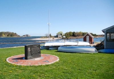
Near Government Island Road 0.1 miles north of Border Street, on the left when traveling north.
Dedicated to the memory of Joseph Antoine and Joseph Wilson, keepers of the first Minot Ledge Lighthouse who, while manning the Light on the night of Apr. 17, 1851, lost their lives when the lighthouse was swept into the sea during a violent . . . — — Map (db m42104) HM
Near Government Island Road 0.1 miles north of Border Street, on the left when traveling north.
On this site 3,514 tons of Quincy granite were hewn into 1,079 dovetailed blocks whose final weight totalled 2,367 tons.
On the two circular forms seen here, the cut stones were carefully assembled to assure perfect fit; then disassembled . . . — — Map (db m42102) HM
On Railroad Avenue south of Alden Street, on the right when traveling north.
Welcome to the Alden House Historic Site Part of original land grant given to Mayflower Pilgrims John and Priscilla Mullins Alden in 1627 and home to generations of Aldens. The property is now a National Historic Landmark and owned by the Alden . . . — — Map (db m177585) HM
Myles Standish Burying ground is the oldest maintained cemetery in the United States. This sacred ground has been cared for by the town of Duxbury Massachusetts, and takes its name from Myles Standish, military leader of the Plymouth colony who was . . . — — Map (db m56227) HM
On King Caesar Road east of Russell Road, on the right when traveling east.
Bumpus Park The Park The King Caesar House was sold in 1946 by the Bumpus family. At that time, this wharf was donated to the Duxbury Rural & Historical Society to serve as a park, dedicated to the memory of Hermon C. Bumpus, Sr. The . . . — — Map (db m177319) HM
On Railroad Avenue south of Alden Street, on the right when traveling south.
John and Priscilla Alden
Family Sites
has been designated a
National Historical Landmark
This site possesses national significance
in commemorating the history of the
United States of America.
Longfellow's 1858 poem The . . . — — Map (db m300768) HM
On Chestnut Street at Pilgrim By-Way, on the right when traveling west on Chestnut Street.
Capt. John Alden, Sr. (c. 1599 - September 12, 1687) was a crew member aboard the Mayflower and arrived in Plymouth Colony in the late-fall of 1620. It is believed that he was from the Alden family of Harwich, England, homeport of the Mayflower. . . . — — Map (db m159950) HM
On Washington Street, on the right when traveling north.
Nathaniel Winsor, Jr. House A Property of The Duxbury Rural & Historical Society
www.duxburyhistory.org
Federal Homes on Washington St. The term “Federal” refers to an architectural style popular between 1780-1830. It is . . . — — Map (db m150422) HM
On St. George Street west of Lovers Lane, on the right when traveling west.
Site of land granted to Philip in 1637 by the Plymouth Colony Court. Born in Leiden, a Huguenot, he came to the Plymouth Colony on the “Fortune” in 1621. A Purchaser, he helped repay the Colony’s debts to English merchants. Well . . . — — Map (db m150282) HM
On Washington Street, on the right when traveling south.
Reynolds-Maxwell Garden
Around 1800, this area of the Blue Fish River was thriving with shipyards, wharves, saw pits, mills and warehouses. By 1900, Duxbury Village (as it was known then) was Duxbury's main commercial district with livery . . . — — Map (db m149421) HM
On Standish Street at Captains Hill Road, on the right when traveling south on Standish Street.
Site of Nook Gate Here a palisade was erected across the Nook in 1634 This palisade was a high fence to prevent cattle from straying and probably to keep the Indians out Town of Duxbury 1940 — — Map (db m147749) HM
On Pilgrim By-Way north of Chestnut Street, on the right when traveling north.
Site of second meeting house 1700 1785 40 x 33 x 17 Ministers John Robinson 1702 1738 Samuel Veazie 1738 1750 Charkes Turner 1755 1775 Zedekiah Sanger 1776 1786 Town of Duxbury 1939 — — Map (db m158486) HM
On Tremont Street north of Depot Street, on the right when traveling north.
The Beginning of the Bradford House “How comes the house, not quite finished yet I suppose…” Gershom Bradford aboard the brig Mercury, to his wife Sally, December 31, 1807. Sarah (Sally) Hickling Bradford supervised the . . . — — Map (db m150330) HM
On Chestnut Street, on the right when traveling west.
Welcome to the Old Burying Ground, c. 1632-1787 The Old Burying Ground (also known as the Myles Standish Burying Ground) is the oldest maintained cemetery in the United States. The first burials occurred here as early as 1632, shortly after . . . — — Map (db m147784) HM
On Pilgrim By-Way north of Chestnut Street, on the right when traveling north.
The Old Burying Ground (also known as the Myles Standish Burying Ground) is the oldest maintained cemetery in the United States. The first burials occurred here as early as 1632, shortly after the area began to be permanently settled by Europeans. . . . — — Map (db m160432) HM
On Pilgrim By-Way north of Chestnut Street, on the right when traveling north.
Capt. Myles Standish. (c. 1584 - October 3, 1656) was one of the passengers aboard the Mayflower, arriving in Plymouth Colony in the late-fall of 1620. Little is known of his early life and career. He was most likely raised in . . . — — Map (db m295955) HM
On Washington Street north of Shipyard Lane, on the left when traveling north.
Between Pembroke and Hanover
First bridge erected
1656
by Wm. Barstow “for foot & horse”
The second, “a cart bridge”
1682 Both by order of the Colony Court.
These were situated 100 feet above this structure
Third bridge built by . . . — — Map (db m175895) HM
On Washington Street north of Shipyard Lane, on the right when traveling north.
Between 1678 & 1871 more than 1000 vessels of from 30 to 470 tons were built Of these in 1772 Ichabod Thomas constructed the ship Bedford and the brig Beaver. The former was the first vessel to display the United States flag in European waters off . . . — — Map (db m175837) HM
On Lincoln Street at North Street, on the left when traveling north on Lincoln Street.
With malice toward none
with charity for all
[Dedicated] September 1939
This monument is presented to the
Citizens of Hingham
by Everett E Whitney
in fond memory of
his father Jason W Whitney
his mother Lydia A Whitney
his wife . . . — — Map (db m118181) HM
On Lincoln Street at North Street, on the left when traveling north on Lincoln Street.
Benjamin Lincoln 1732 1810
Selectman 1765 — 1771
Town Clerk 1757 — 1776
Member of Provincial Congress
at Concord, Cambridge & Watertown
Major General in the Army of the Revolution
Secretary of War 1781 — 1783
Lieut - Governor of . . . — — Map (db m295944) HM
On North Street at Lincoln Street, on the left when traveling east on North Street.
General Benjamin Lincoln House
has been designated a
Registered National
Historic Landmark
under the provisions of the
Historic Sites Act of August 21, 1935
This site possesses exceptional value
in commemorating or . . . — — Map (db m299145) HM
Near Hersey Street north of Lewis Court, on the right when traveling north.
Today's Burns Memorial Park, a wilderness neighborhood park owned by the Hingham Conservation Commission, includes pine-covered ledges, meadow, and red maple swampland. These 26.59 acres represent the publicly owned piece of what was once the . . . — — Map (db m299414) HM
On Beal Street at Sgt. William B. Terry Drive, on the right when traveling east on Beal Street.
Near this spot stood the third Almshouse, commonly known as the "Town Farm". Erected by the town of Hingham in 1832, it served for more than 100 years as a place of refuge for the elderly, destitute, and others whose circumstances rendered them . . . — — Map (db m299413) HM
First Meeting House raised shortly after the gathering of the church in 1635 within a palisade.
First Burying Ground, First School House built prior to 1661. Fort erected in 1676. These landmarks were located upon this hill, the . . . — — Map (db m2850) HM
On Main Street at Elm Street, on the right when traveling west on Main Street.
Erected in 1681, it is the oldest church structure in the United States to have been used continuously for public worship. Samuel Lincoln, original American ancestor of Abraham Lincoln, worshipped here regularly. — — Map (db m298457) HM
On Summer Street (Massachusetts Route 3A) at Water Street, on the left when traveling east on Summer Street.
This flagpole was erected and dedicated
on June 14, 1986
through the determination of
Robert F. Beal, Jr., Vietnam Veteran
and kind generosity of Thomas Hastings
In memory of the
POW/MIA’s still held in Southeast Asia
With the . . . — — Map (db m118130) WM
In grateful memory of Reverend Peter Hobart and that company of English men and women who founded the town of Hingham, landing near this spot in September, 1635 — — Map (db m2851) HM
On North Street at Lincoln Street, on the right when traveling east on North Street.
Samuel Lincoln, ancestor of President Abraham Lincoln, and one of the eight early settlers of Hingham bearing that name, purchased this land in 1649. Seven generations of Lincoln descendants lived here. — — Map (db m298458) HM
On Pond Street just south of Main Street (State Route 228), on the left when traveling north.
Near this spot stood the second Almshouse erected by the Town of Hingham in 1817 and destroyed by fire in 1831. It served as a refuge for those unable to care for themselves. — — Map (db m297476) HM
Near Triphammer Road, on the right when traveling east.
The Matthew Cushing Family built the first mill on this site circa 1700. The mill was used by the Cushing Family for over 100 years until it burned down in 1823. During this time the mill produced various lumber products from local timber. A new . . . — — Map (db m290689) HM
On Sheltry Path at Bare Cove Path, on the right when traveling north on Sheltry Path.
Near this spot stood the third Almshouse, commonly known as the "Town Farm". Erected by the town of Hingham in 1832, it served for more than 100 years as a place of refuge for the elderly, destitute, and others whose circumstances rendered them . . . — — Map (db m299411) HM
On Beal Street at Route 3A, on the left when traveling north on Beal Street.
The Weymouth Back River and the land surrounding the river are important ecological resources in Massachusetts. However, the river's economic history has left lasting markers on the landscape. The following narrative provides a brief history . . . — — Map (db m302403) HM WM
Near Beal Street at Sgt. William B. Terry Drive, on the right when traveling east.
Near this spot stood the third Almshouse, commonly known as the "Town Farm". Erected by the town of Hingham in 1832, it served for more than 100 years as a place of refuge for the elderly, destitute, and others whose circumstances rendered them . . . — — Map (db m299250) HM
Near Main Street (Massachusetts Route 228), on the right when traveling south.
This tablet placed by Old Colony Chapter, Daughters of the American Revolution in November 1960 commemorates the 325th anniversary of the Establishment of the Town of Hingham. Opposite stands the Second Parish Church, built in 1742. The first . . . — — Map (db m298972) HM
On Main Street at Leavitt Street, on the left when traveling south on Main Street.
Here stands the “Sprague” Bottonwood Tree. A living historical landmark transplanted in 1793. Dedicated to Francis H. Ford upon his retirement as Tree Warden for the Town of Hingham. — — Map (db m301763) HM
On Short Street (Massachusetts Route 228) at Middle Street, on the right when traveling north on Short Street.
This plan shows the outline of the original Training Field which extended from Pleasant Street on the South to Leavitt Street on the North and from Spring and School Streets on the East to Main and Pond Streets on the West. It was called The . . . — — Map (db m299394) HM
On Common Street at Middle Street, on the left when traveling east on Common Street.
In memoriam to Hingham's war dead of World War II 1941-1945 •Robert W. Allen •Edward R. Howard •Lawrence F. Ripley •Sherrard Billings 2nd •John P. Ingram Jr. •Allan M. Rogers •Robert J. Brennan •Charles E. Kearns •John David Root •Russell William . . . — — Map (db m299134) WM
On Common Street at Middle Street, on the left when traveling east on Common Street.
These trees and this stone Hingham dedicates in gratitude to the memory of her sons who laid down their lives for liberty and civilization
1917 - 1919
Corp. Alexander R. Borland • Moses E. Delorey • Harold C. Barrett • Maurice A Linehan • . . . — — Map (db m299331) WM
On Common Street near Middle Street, on the left when traveling east.
Vietnam War
1961 - 1975
Their Sacrifice is not Forgotton
James R. Byrne • Robert E. Ryan • Curtis E. Chase • William B. Terry • Charles T. McNutt • Barry L. Wolk — — Map (db m299131) HM
On Short Steet (Massachusetts Route 228) at Leavitt Street, on the left when traveling north on Short Steet.
Near this spot, the first Almshouse was erected by the Town of Hingham in 1785. It served as a place of refuge for those unable to care for themselves — — Map (db m297474) HM
On Healthy Heart Trail 0.3 miles east of Union Street, on the right when traveling east.
Josiah Wompatuck was born in 1627. He was the son of Chief Chikataubut of the Massachusetts tribe. In 1633, Chief Chikataubut died of smallpox and Wompatuck was taken in and raised by his uncle, a member of the Wampanoag tribe. Wompatuck became . . . — — Map (db m308387) HM
On Healthy Heart Trail 0.3 miles east of Union Street, on the left when traveling north.
Chief Wompatuck gave the land to the English settlers who used the tall trees in the forest to make masts for their ships. Then, in the 1800s, the land was used by residents for woodlots and powering mills. Even then, the Mt. Blue Spring was a . . . — — Map (db m295662) HM
On Healthy Heart Trail 0.5 miles east of Union Street, on the left when traveling west.
Wompatuck State Park, now at 3,526 acres, was previously known as the Cohasset Naval Annex. The land for the Annex was bought for the U.S. Navy in 1941 to serve as the main supplier of armaments for the Atlantic fleet during WWII and again for . . . — — Map (db m295690) HM
Bastion C is the only bastion retaining its original form and protective outworks. It is one of five arrowhead-shaped corners which were built as the fort’s strongest strategic locations. The bastion form was developed in Italy at the end of the . . . — — Map (db m62578) HM
Battery Bartlett was built in the 1890's atop the fort's original earthen ravelin (triangular fortification in front of the bastions). A major upgrade to earlier batteries, it protected the Nantasket Roads and the Narrows Channels into Boston and . . . — — Map (db m59209) HM
On Spring Street west of Spinnaker Island Causeway, on the right when traveling west.
Renowned coloratura soprano, noted
both in Europe and America for her
marvelous voice, her wonderful art,
and charming personality.
Passed to spirit life April 3, 1925.
With deepest sorrow we mourn and cry
"Until we meet again" Goodby, . . . — — Map (db m118054) HM
Dedicated July 14th by the Republic of France and the people of Hull in celebration of the United States of America bicentennial. In grateful tribute to the French sailors and marines who served and died at Fort Independence during the American . . . — — Map (db m56068) HM
On Spring Street at Spinnaker Island Causeway, on the right when traveling west on Spring Street.
To honor the
Gold Star Mothers of Hull
in memory of their sons
who died in the service
of their country
that liberty might live
World War I
Marie Long • Mary Howard • Esther Mitchell
Mary Shaw • Margaret Canary
World War II . . . — — Map (db m118113) WM
On Main Street at Highland Avenue, on the right when traveling east on Main Street.
Poet • Patriot
Friend of Freedom
and Humanity
Ardent lover of
his native country
Devoted to his
adopted land
Born in Ireland • June 28 1844
Died on this spot • His summer home
August 10 1890
Memorial erected by the . . . — — Map (db m118046) HM
On Main Street at Highland Avenue, on the right when traveling east on Main Street.
Irish Patriot, Activist for Minority Rights,
Poet, Editor of The Pilot
——————————
Mary Murphy O'Reilly
Journalist for The Young Crusader
pen name: Agnes Smiley . . . — — Map (db m118045) HM
On Main Street at Highland Avenue, on the right when traveling east on Main Street.
Built on the site of the
Old Hunt Estate
——————————
Susanna Haswell Rowson
(daughter)
Early Womens' Rights Advocate, Actress, Poet
Educator, Novelist, Author of . . . — — Map (db m118047) HM
On Nantasket Avenue at Wharf Avenue, on the left when traveling north on Nantasket Avenue.
Memories of Paragon Park
In the year 1905 Paragon Park opened as an ocean front resort amusement park at Nantasket Beach, Massachusetts. Rose and David Stone acquired this popular palatial playground in 1920 and they were later joined by . . . — — Map (db m118042) HM
On Spring Street west of Spinnaker Island Causeway, on the right when traveling west.
Interred herein are approximately
100 men, women and children
known only to God.
Victims of shipwrecks
on our shores, nearby islands
or shoals, from
1860 to 1898.
Erected in their memory — — Map (db m118049) HM
On Farina Road east of Nantasket Avenue, on the left when traveling east.
Telegraph Hill
Hull, Massachusetts
The Greek meaning for "telegraph” was to “write far”. Over the
years there have been various systems employed to transmit
messages over a distance. These include smoke signals, fireballs
of pitch and oakum, . . . — — Map (db m308619) HM
Originally an open courtyard, Bastion A was roofed over, probably in the 1870's to accommodate new artillery-15-inch Rodman Guns. The new space was divided into an indoor drill hall, a powder magazine and a storage area for wagons and gun carriages. . . . — — Map (db m59208) HM
The Brewster Islands
Calf Island • Great Brewster Island • Middle Brewster Island • Little Brewster Island & Boston Light • Outer Brewster Island • Shag Rocks
As you look out into Boston Harbor, about a mile and a half directly . . . — — Map (db m308583) HM
On Nantasket Avenue at Phipps Street, on the left when traveling east on Nantasket Avenue.
The People of the Town of Hull
remember those who served their country
Forget 'Nam'? Never!
[bronze relief]
Dedicated June 23, 2013 — — Map (db m118115) WM
On Samoset Avenue at Nantasket Street, on the left when traveling west on Samoset Avenue.
Hull pays tribute
to her valiant sons
who have upheld the
honor of her traditions
in the service of their country
Dedicated May 30 MCMXXIV
Monument Re-built 1949
[War Reliefs]
1775 • 1812 • 1861 • 1898
1917 • 1941 • 1950 • . . . — — Map (db m118121) WM
On Farina Road east of Nantasket Avenue, on the left when traveling east.
A Fascinating Tale
Fort Revere is one of the most beautiful military landmarks in the State, but is it haunted? When the Revolutionary War was raging across New England in 1778 over 200 French patriots, who were supporting the rebellion in Canada, . . . — — Map (db m308532) HM
Fort Revere Officers' Quarters, c. 1903
DCR's Historic Curatorship Program
Preserving the past through public-private partnership
The 1903 Fort Revere Officers' Quarters in the latest
property to be preserved through DCR's . . . — — Map (db m308568) HM
On Farina Road east of Nantasket Avenue, on the left when traveling east.
Fort Revere Park
The Early Years - The summit of Telegraph Hill, the site of Fort
Revere, originally was considered as a site for a fort as early
as 1633 Around 1775 Gen Joseph Palmer, using French styled
military architecture, created a . . . — — Map (db m308469) HM
TOWER ON TELEGRAPH HILL
Hull, Massachusetts
Erected by the Hennebique Construction Company in 1903
on orders from the US Government, the current tower is
one of the earliest steel reinforced concrete water towers
in the United States and . . . — — Map (db m308685) HM
On Farina Road east of Nantasket Avenue, on the left when traveling east.
In Memory of
The French Military who Died in Hull
ILS SONT MORTS POUR NOTRE LIBERTE
Name Unit Date of Death
Jean Le Ne Angoumois 1782
Antoine Sorrent Angoumois 1782 — — Map (db m308452) HM WM
On Howlands Lane 0.1 miles north of Standish Avenue, on the right when traveling north.
Historic site of the 1676 home of Joseph Howland who lived here until his death in 1703/4. He was the son of John Howland a passenger on the Mayflower who purchased this property in 1638. Erected in 1963 by the Pilgrim John Howland Society. — — Map (db m300766) HM
In the year 1776.
The Brig Independence
Set sail from Kingston's
Jones River to protect the ships
and coastline of
Massachusetts. — — Map (db m85499) HM
On Howlands Lane north of Standish Avenue, on the right when traveling north.
Here stood the home of John Howland and his wife Elizabeth Tilley Howland from 1638 until his death February 23, 1673. Both were passengers in the ship Mayflower.
In grateful remembrance, this land has been bought by their descendants and . . . — — Map (db m302670) HM
Near Winslow Cemetery Road at Presidential Circle, on the right when traveling south.
1782 Daniel Webster 1853
He belongs to the Nation whose union,
rock-ribbed, he so largely wrought.
Beloved son, Class of 1801, of the
College he loved, his defense of her
independence in the Dartmouth College
case before the Supreme . . . — — Map (db m304831) HM
Near Winslow Cemetery Road at Presidential Circle, on the left when traveling north.
Daniel Webster
Born January 18, 1782
Died, October 24, 1852
"Lord, I believe, help thou
mine disbelief."
Philosophical
argument, especially
that drawn from the vastness of
the Universe, in comparison with the
apparent . . . — — Map (db m304838) HM
On Ocean Street (Massachusetts Route 139) at Moraine Road ( Route 3A), on the left when traveling west on Ocean Street.
This tablet is erected by
John Adams Chapter
Daughters of the American Revolution
In patriotic remembrance
Daniel Webster
1782-1852
Peerless debator, a brilliant orator
A profound constitutional lawyer
A patriotic . . . — — Map (db m47057) HM
On Canal Street north of Bay Street, on the right when traveling east.
From Greens Harbor River
to Duxbury Bay
1636 Ordered that the
Cutt at Greens Harbor
for a Boat passage Shal
be made Eighteen Foote
Wide and Sixe Foote Deep. — — Map (db m271346) HM
Near Winslow Cemetery Road at Presidential Circle, on the right when traveling south.
In Memory of
the Early Settlers
at Green Harbor
Marshfield
Edward Winslow and wife Susanna • Kenelm Winslow and wife Ellen • Josiah Winslow and wife Margaret • Josiah Winslow and wife Penelope • William Thomas • Nathaniel Thomas and wife . . . — — Map (db m304812) HM
Near Winslow Cemetery Road north of Presidential Circle, on the left when traveling north.
Edward Winslow
Founder of Marshfield
Edward Winslow, son of Edward Winslow and Magdalene Ollyver,
born Droitwich, England 18 October 1595.
1617 joined dissident English separatists in Leyden, Holland
1618 married Elizabeth Barker who died . . . — — Map (db m304565) HM
On Ocean Street (Massachusetts Route 139) at Moraine Street ( Route 3A), on the right when traveling west on Ocean Street.
First Church of
Marshfield
Gathered 1632
First building at Winslow Cemetery 1641
First located on this site 1706
Present church built 1838
Here the Tory Resolves of the Town of Marshfield were passed January 31, 1776
Old . . . — — Map (db m304541) HM
On Winslow Cemetery Road west of Presidential Circle, on the left when traveling north.
Erected about 1641, a small building with a thatched roof stood a little north of this enclosure. It was sold in 1657 for 50 shillings when a new church was built near the site of the present First Congregational Church. Here are to be found the . . . — — Map (db m304464) HM
On Main Street (Massachusetts Route 3A) near Plain Street ( Route 139), on the left when traveling north.
Site of first grist mill in Marshfield. Built by Josiah Winslow and William Ford prior to 1657.
Dunham’s saw mill 1814-1835 Duxbury and So. River Manufacturing Co.
Erected by Marshfield Historical Commission 1971 — — Map (db m218898) HM
On Ocean Street (Massachusetts Route 139) at Moraine Road ( Route 3A), on the left when traveling west on Ocean Street.
The Old Marshfield Training Field and Meetinghouse of the First Parish where Daniel Webster attended church.
Home of Daniel Webster. Home of Governor Edward Winslow. Historic Winslow House is open to visitors in summer. — — Map (db m48763) HM
Near Winslow Cemetery Road north of Presidential Circle, on the left when traveling north.
Site of First Church
1641 - 1657
Early town meetings
and school sessions
held here.
Uninscribed field stones mark oldest graves. — — Map (db m304444) HM
On Moraine Street (Massachusetts Route 3A) just north of Tea Rock Gardens, on the right when traveling south.
Tea Rock Hill
On this hill in December 1773 the
staunch Whig, Jeremiah Lowe, applied
the torch and burned the tea
confiscated by the Patriots from public
and private stores in the town
of Marshfield.
Erected by Tea Rock Chapter D.A.R. . . . — — Map (db m304553) HM
On Winslow Cemetery Road at Webster Street, on the left when traveling south on Winslow Cemetery Road.
The Home of
Daniel Webster
from Apr. 23, 1832 until his death Oct. 24, 1852
lawyer, statesman orator
his grave is in the ancient cemetery
at the northerly side of the estate
-------
To commemorate these places and events
this tablet . . . — — Map (db m304834) HM
On Winslow Street at Kenelm Drive, on the left when traveling north on Winslow Street.
Kenelm Winslow Homestead
c.1645
Born Droitwich, England 1599
Received 100 Acre Grant March 5, 1637
Brother of Pilgrim Edward Winslow
Representative to General Court for Eight Years
Died Salem, 1672 — — Map (db m305004) HM
On Main Street (Massachusetts Route 123), on the right when traveling west.
Site of the home of
Nathan Cushing
Judge of Admiralty in the Revolution
Judge of Supreme Court of Massachusetts 1789–1810
State Councilor 1779–1780 1802–1807
Dec 13, 1780 the council ordered that Nathan Cushing Esq
be . . . — — Map (db m50357) HM
Near Main Street (Massachusetts Route 123) at River Street.
The “Columbia,” an 83 foot long ship built in 1773 at Hobart’s Landing in Norwell, MA, on the North River, was the first American ship to circumnavigate the globe. — — Map (db m216993) HM
199 entries matched your criteria. The first 100 are listed above. Next 100 ⊳