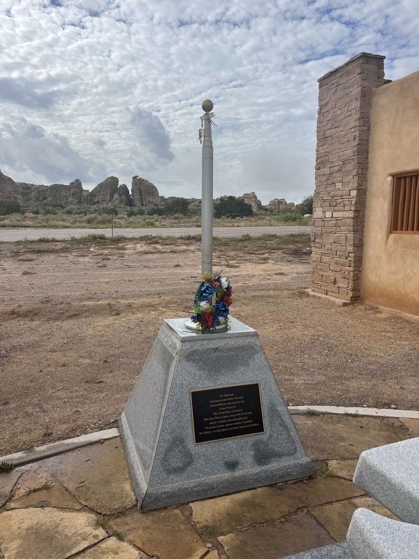
Near Indian Service Road 38 close to Indian Service Rd. 37, on the left when traveling south.
This Memorial Dedicated to the Pueblo of Acoma Veteran/Warriors who served in the Armed Forces of The United States of America With their Warrior Spirit, along with all Veterans, shared a common and undeniable goal "To protect Acoma, and our . . . — — Map (db m311954) WM
On Main Street (State Road 606) south of Plano Colorado Road (County Road 28A), on the right when traveling south.
This community was founded in 1894 on the site of
an earlier homestead and stage coach stop. Irrigation
from Bluewater Lake and its proximity on the railroad
and Route 66 allowed development of extensive
agricultural fields, which earned . . . — — Map (db m236574) HM
On Sky City Road, on the left when traveling north.
Legend describes Acoma as a "place that always was". Archeological evidence shows it has been occupied since at least the 13th century. Established on this mesa for defensive purposes, Acoma was settled by inhabitants of nearby pueblos which had . . . — — Map (db m280091) HM
Built atop a great mesa for defensive purposes, Ácoma has been continuously occupied since the 13th century. A dramatic battle between the Ácomas and Oñate's forces occurred here in 1599. The mission church of San Esteban was built between 1629 and . . . — — Map (db m280089) HM
Near Indian Service Route 30 south of Interstate 40.
Keresan speaking refugees from Santo Domingo, Acoma, Cochiti, and other pueblos founded Laguna after the Pueblo Revolt of 1680 and the Spanish reconquest of 1692. Named by the Spaniards for a marshy lake to the west, the pueblo still occupies its . . . — — Map (db m280088) HM
On State Road 36 at County Road 601, on the right when traveling north on State Road 36.
There is a mysterious force that drives people to new lands and new frontiers. There is an abiding love for the land and newly turned soil, for young livestock and for the freedom of ownership, for the independence of spirit. This marker will remain . . . — — Map (db m94982)
Created December 31, 1987-Dedicated August 24, 1991. The El Malpais National Conservation Area (NCA) was the first area so designated by Congress in New Mexico. Congress established the NCA to conserve and protect the . . . — — Map (db m100422) HM
On State Road 117 0.3 miles north of Interstate 40, on the right when traveling north.
Located just north of the great lava bed known as the malpais, Grants began as a coaling station for the Santa Fe Railroad. Around 1880 it was known as Grant's Camp, after the Canadian bridge contractor Angus A. Grant. In 1950, the area's vast . . . — — Map (db m280086) HM
On West Santa Fe Avenue (Historic Route 66) 0.1 miles east of State Road 53, on the right when traveling east.
Located just north of the great lava bed known as the malpais, Grants began as a coaling station for the Santa Fe Railroad. Around 1880 it was known as Grant's Camp, after the Canadian bridge contractor Angus A. Grant. In 1950, the area's vast . . . — — Map (db m280087) HM
On Ice Cave Road 0.6 miles south of Ice Caves Road (State Highway 53), on the right when traveling south.
The Bandera Volcano rose up in volcanic fury some 10,000 years ago. The crater is approx. 1400 feet across and 800 feet deep. Bandera is one of the finest examples of an erupted volcano in the country, and one of the most accessible. An ancient lava . . . — — Map (db m164176) HM
On Iron Avenue just north of U.S. 66, on the right when traveling north.
This drill bit was used at Crownpoint N.M. to drill a 10 ft. diameter shaft 2,234 ft. The drill cutters weigh 30,000 lbs. Total assembly weight is 443,000 lbs. One third of its weight was used for cutting purposes. The rest of the weight as a . . . — — Map (db m164162) HM
As a protected volcanic region, the land in El Malpais National Monument provides many geological curiosities to be explored and viewed. However, remnants of World War II military training activities may still be hidden within the national . . . — — Map (db m285137) HM
On State Road 53 at milepost 83.1, 2.5 miles south of Interstate 40, on the right when traveling north.
San Rafael, formerly know as El Gallo, is located at a spring near the Malpais, the great lave flow to the east. The area was visited by members of Vásquez de Coronado's expedition in 1540. In 1862, it was selected as the original site of Fort . . . — — Map (db m280085) HM
On Iron Avenue at U.S. 66, on the left when traveling north on Iron Avenue.
The caboose, 999726, was built circa 1937 originally for the Chesapeake and Ohio Railroad. It was donated to the Grants-Cibola County Chamber of Commerce by BNSF and many years later in 2015, the Chamber passed the caboose on to the City of Grants. . . . — — Map (db m186515) HM
On U.S. 66 at Iron Avenue, on the right when traveling west on U.S. 66.
This bucket was used to retrieve gold & silver ore as well as miners from the depths of the Fannie mine at Mogollon, NM Donated by Red & Nina Waldie Family 2006 — — Map (db m186517) HM
Twisted masses of volcanic rock appear almost as if out of nowhere on the El Malpais stretch of Interstate 40. These rivers of rock are lava flows, which erupted from not one but several volcanoes within El Malpais National Monument. The volcanoes . . . — — Map (db m285136) HM
Economic Impacts
Laguna, like many pueblos, had a strong and self-sufficient agricultural system well into the twentieth century. After World War II, farming and sheep herding started to decline, although some families continue these . . . — — Map (db m184206) HM
On Historic Route 66 (Interstate 40 at milepost 113.5), on the right when traveling west.
Keresan speaking refugees from Santo Domingo, Acoma, Cochiti, and other pueblos founded Laguna after the Pueblo Revolt of 1680 and the Spanish reconquest of 1692. Named by the Spaniards for a marshy lake to the west, the pueblo still occupies its . . . — — Map (db m280083) HM
On Interstate 40 at milepost 113.5, on the right when traveling east.
Keresan speaking refugees from Santo Domingo, Acoma, Cochiti, and other pueblos founded Laguna after the Pueblo Revolt of 1680 and the Spanish reconquest of 1692. Named by the Spaniards for a marshy lake to the west, the pueblo still occupies its . . . — — Map (db m280084) HM
On Interstate 40 at milepost 113.5, on the right when traveling west.
The picturesque mission church of San José de la Laguna was built around 1706 by Fray Antonio Miranda and shows the single – aisle floor plan commonly used in pueblo churches. It has been repaired many times, and acquired its distinctive white . . . — — Map (db m280081) HM
On Interstate 40 at milepost 113.5, on the right when traveling east.
(Front of Marker:)
The picturesque mission church of San José de la Laguna was built around 1706 by Fray Antonio Miranda and shows the single – aisle floor plan commonly used in pueblo churches. It has been repaired many times, and . . . — — Map (db m280082) HM
On Interstate 40 at milepost 113.5, on the right when traveling east.
Educated at the Carlisle Indian School in Pennsylvania under the U.S. policy of acculturating Indian children through school and removal from their homelands, Susie was instrumental in bringing education back to Laguna. A lifelong teacher, oral . . . — — Map (db m280080) HM
Business Along Route 66
As traffic along the road increased, Laguna community members began to sell or trade items at roadside stands within the Pueblo and on adjoining lands to the east and west. Community members built shade structures . . . — — Map (db m184000) HM
On Old Route 66 (State Road 124 at milepost 17), 0.5 miles east of Offramp 107 (Interstate 40).
The Battle of Khe Sanh claimed the lives of 2,097 United States servicemen. This historic marker is dedicated to honor and preserve the memory of New Mexico Servicemen who were killed in action or later died of their wounds. The Khe Sanh Vietnam . . . — — Map (db m70175) WM
Near El Morro National Monument Road 0.9 miles Ice Caves Road ( Highway 53).
Atsinna, which means where pictures are on the rock, was occupied from roughly 1275 to 1400 by ancestors of today’s Zuni people. Eighteen rooms were excavated in 1954, 1955, and 1961. Today, however, the focus at El Morro has shifted from . . . — — Map (db m163205) HM
On State Road 53, on the right when traveling west.
Until it was by-passed by the railroad in the 1880’s, its waterhole made El Morro an important stop for travelers in the Acoma-Zuni region. Numerous inscriptions carved in the sandstone date from the prehistoric, Spanish, Mexican, and Territorial . . . — — Map (db m280079) HM
Near El Morro National Monument Road 0.9 miles Ice Caves Road (State Highway 53).
Also known as squawbush, this aromatic shrub is a member of the same plant family that includes poison ivy, cashews, pistachios, and mangos. The stems of this plant have been used by Native Americans for many years in basketmaking, while the tart . . . — — Map (db m163237) HM
On Ice Caves Road (New Mexico Route 53 at milepost 42.2), 0.8 miles east of Indian Service Route 125, on the right when traveling east.
Matilda Coxe Stevenson (1849-1915). Matilda Coxe Stevenson was the first female anthropologist to study the Native Americans of New Mexico. Her research focused on the religious practices of indigenous peoples, particularly of the Zuni, and . . . — — Map (db m280078) HM
Near El Morro National Monument Road 0.9 miles Ice Caves Road (State Highway 53).
Living and working at El Morro in the early 1900s was an adventure in itself. The duty station was remote, the dirt roads leading in and out were often impassible during wet weather, and a lack of running water or electricity made living conditions . . . — — Map (db m163200) HM
Near El Morro National Monument Road 0.9 miles Ice Caves Road ( Highway 53).
Before the days of interstates and automobiles, a journey from Albuquerque to Zuni (about 150 miles) typically took 9 or 10 days. Imagine the relief travelers must have felt when they reached this shady little oasis after walking or riding a horse . . . — — Map (db m163216) HM
Near El Morro National Monument Road 0.9 miles south of Ice Caves Road (State Highway 53).
The inscriptions and petroglyphs at El Morro are an important link to the past. Although they are very old, they will not be here forever. Sand grains are washed away, rocks crumble and fall, and lichens and clay deposits cover the historic . . . — — Map (db m163201) HM
On El Morro National Monument Road 0.6 miles south of Ice Caves Road (State Highway 53), on the right when traveling south.
From the early Puebloan people who built their homes atop this rock, to the many explorers and adventurers who carved their names, to modern visitors who travel here looking for the evidence of those who came before, El Morro reflects the history of . . . — — Map (db m163199) HM
On El Morro National Monument Road 0.1 miles south of Ice Caves Road (State Highway 53), on the right when traveling south.
Carved into the soft sandstone cuesta before you is a lingering history of the American Southwest. The names of the celebrated, the infamous, the legendary, and the unknown are immortalized side by side where they would otherwise be separated by . . . — — Map (db m163198) HM
On BIA Route 38 (Road 38 at milepost 2), 10.2 miles south of I-40 (Road 28).
Legend describes Acoma as a "place that always was". Archaeological evidence shows it has been occupied since at least the 13th century. Established on this
mesa for defensive purposes, Acoma was settled by inhabitants of nearby pueblos which had . . . — — Map (db m280092) HM
On I-40 Frontage Road (U.S. 66) at County Road 566, on the right when traveling west on I-40 Frontage Road.
Great cliffs of red sandstone form the southern boundary of the San Juan basin. The strata that are exposed here are the gently upturned edge of the structural basin which contains coal, uranium, oil and gas resources. The Zuni mountains to the . . . — — Map (db m280167)
On New Mexico Route 118 west of South 1st Street, on the right when traveling west.
In 1880, a paymaster for the Atlantic and Pacific Railroad, David L. Gallup, established headquarters along the construction right-of-way of the southern transcontinental route. The railroad workers began "going to Gallup" to get their pay; thus a . . . — — Map (db m184302) HM
Near New Mexico Route 118 east of South 1st Street.
101 North Third Street (circa 1887)
Adequate transportation has been the answer to successful business entrepreneurs in the Gallup area as early as the late 1880's. Clinton N. Cotton, a shrewd Yankee trader and businessman, concluded that . . . — — Map (db m184301) HM
On New Mexico Route 118 west of South 1st Street, on the right when traveling west.
Miners hand-loaded coal cars, like this one, deep underground. Several cars hitched together were called a "trip." When full, a "trip" of coal cars were hoisted to the surface and dumped into larger railroad cars. The "hoist" and cars displayed here . . . — — Map (db m184317) HM
Coal mining was one of Gallup's biggest industries from the 1880s through the 1950s. Mining jobs drew workers from across the nation and around the world. Wages were good and housing was often provided. Over time fifty-seven mines in the Gallup . . . — — Map (db m255832) HM
On Interstate 40 Frontage Road (State Road 118), on the right when traveling west.
Long a major trading center for the Navajo and Zuni Indians living in communities north and south of the town. Gallup emerged in 1881 from a railroad construction camp. It is named for David Gallup, who in 1880 was paymaster for the Atlantic & . . . — — Map (db m280168) HM
On West Coal Avenue at South 2nd Street, on the left when traveling east on West Coal Avenue.
The first Gallup Inter-Tribal Indian Ceremonial was held in Gallup on September 22, 1922. Ceremonial was initiated by traders and the Chamber of Commerce. In the early days natives came in wagons and camped in the surrounding hills. Tourists from . . . — — Map (db m255836) HM
Near New Mexico Route 118 east of South 1st Street.
Gallup, New Mexico, the Indian Capital of the World is known as the epicenter of Native American history, art, culture and tradition in the southwest.
Europeans, Asians, and Mexicans came to build the railroad, and many stayed on to mine . . . — — Map (db m184299) HM
On New Mexico Route 118 west of South 1st Street, on the right when traveling west.
Gallup has some of the Southwest's largest trading posts and one of the best strips of neon signs you'll see anywhere on old Route 66," boasts the website Road Trips USA.
Neon signs are part of Gallup's heritage and once the calling card . . . — — Map (db m184303) HM
Near West Aztec Avenue at South 2nd Street, on the left when traveling east.
The Atlantic and Pacific Railroad construction crews reached mile marker 157.5 in 1881. As the rails moved west railroad crews and suppliers would go to David L. Gallup, paymaster, for their pay. They had to go to Gallup. The name stuck. . . . — — Map (db m255826) HM
Near New Mexico Route 118 east of South 1st Street.
One by one new brick buildings changed the look for downtown Gallup. Railroad Avenue had to keep pace with the eastern style buildings being erected along Coal Avenue. Maroon glazed tile became the sign of storefront modernization. With the . . . — — Map (db m184296) HM
On New Mexico Route 118 west of South 1st Street, on the right when traveling west.
This machine is a "hoist" used to bring a "trip" of coal cars to the surface. The hoist is basically a large winch using cable attached to the "trip" to hoist it the surface. This hoist was used from the 1890s to the 1950s. Coal mined in Gallup was . . . — — Map (db m184316) HM
Near 11th Street 0.1 miles south of West Aztec Avenue.
This memorial was erected in memory of the young individuals who went to war as kids and lost their youthful dreams, and some their lives, for a cause – freedom and honor – and came back as men with the horrors of war instilled in every . . . — — Map (db m36559) HM
Near New Mexico Route 118 east of South 1st Street.
Established September 28, 1922
In August, 2011 Gallup played host to the 90th Inter-Tribal Indian Ceremonial where, Native Americans from across the United States participate in a massive celebration and display of their culture. The Indoor . . . — — Map (db m184300) HM
Near New Mexico Route 118 east of South 1st Street.
218½ West Historic Highway 66 (circa 1895)
One of Gallup's oldest standing buildings housed activities for nearly one-half a century modeling a significant course for early development of this railroad and mining opportunity.
Kitchen's . . . — — Map (db m184298) HM
On South 3rd Street (New Mexico Route 610) at West Hill Avenue, on the right when traveling south on South 3rd Street.
In 1864 during a period of destabilization among U.S. settlers, Spanish inhabitants and Native Americans, the Navajo and some Apache were singled out by the U.S. government as responsible for raiding. Thousands of Navajo people were forcibly marched . . . — — Map (db m148698) HM
Near New Mexico Route 118 east of South 1st Street.
This is the greatest highway project in America!... read the headline in the April 15, 1927 edition of the Gallup Independent. From Chicago to Los Angeles the "Main Street of America" would be U.S. 66. The National Old Trails Highway was on the . . . — — Map (db m184294) HM
On South 2nd Street (New Mexico Route 610) north of West Coal Avenue, on the left when traveling north.
This mural shows the Navajo Code Talkers, U.S. Marines in World War II, who defended this country with the sacred Navajo language, bringing the Code Alphabet home from war to the future generations as a symbol to perpetuate the Navajo language and . . . — — Map (db m148699) HM
On West Historic Highway 66 (State Road 118) at South 3rd Street, on the left when traveling west on West Historic Highway 66.
[Top]
Donated to the City of Gallup
on December 16, 1986
by
C.P.S. Associates
(The Caviggia, Petranovich and Smith Families)
[Bottom]
The Rex Hotel
circa 1900
has been placed on the
National . . . — — Map (db m236477) HM
On West Aztec Avenue at South 2nd Street (State Route 610), on the left when traveling east on West Aztec Avenue.
Centuries before Gallup's founding in 1881 this was a region of interweaving native cultures, Navajo, Hopi and Zuni. Resources of coal, timber, railroads and trading attracted settlers who created a city of increasing cultural diversity.
We . . . — — Map (db m148758) HM
On South 2nd Street (New Mexico Route 610) south of West Hill Avenue, on the right when traveling north.
The Zuni Pueblo is 40 miles south of Gallup. Zuni land-use area, which included what is now Gallup, has been inhabited since 1,000 BC. By 1350 AD agriculture was fully developed and there were approximately 36 active Zuni pueblos. The Spanish . . . — — Map (db m148701) HM
On Joseph M Montoya Boulevard (State Road 609) 0.2 miles east of Marguerite Franco Drive, on the right when traveling east.
Emma Estrada (1933-1997) Emma Estrada was a partera, or midwife, for over thirty years. She delivered more than seven hundred babies during an era when mothers in rural, sparsely populated areas had no choice but to deliver at home. . . . — — Map (db m280170) HM
On Lupton Road (Interstate 40), on the right when traveling east.
This area contained many Indian pueblos dating from about A.D.
500 to 1325, when it was abandoned. Navajos settled here by
1800. This was the home of Manuelito, one of the last of the
chiefs to surrender for confinement at the Bosque Redondo . . . — — Map (db m162257) HM
On State Road 400 at milepost 3 at Main Street, on the left when traveling south on State Road 400.
The first Fort Wingate was established near San Rafael in 1862, to serve as the base of Col. Kit Carson's campaigns against the Navajos. In 1868 the garrison was transferred to the second Fort Wingate near Gallup. In that same year, the Navajos . . . — — Map (db m280171) HM
On Road 53 at milepost 14, on the right when traveling west.
The six original Zuni pueblos were the legendary "Seven Cities of Cibola" sought by Vasquez de Coronado in 1540. They were abandoned during the Pueblo Revolt, and the present pueblo was settled in 1699 after the Spanish reconquest. In 1970 Zuni . . . — — Map (db m280172) HM
On State Road 53 at milepost 11, on the right when traveling east.
The six original Zuni pueblos were the legendary "Seven Cities of Cibola" sought by Vasquez de Coronado in 1540. They were abandoned during the Pueblo Revolt, and the present pueblo was settled in 1699 after the Spanish reconquest. In 1970 Zuni . . . — — Map (db m280173) HM
On State Road 53 at milepost 17, on the right when traveling east.
The Zuni Olla Maidens are an all-women's group renowned for their skill and ability to balance fragile water jars or ollas on their heads. Historically, Zuni women collected water in ollas from nearby springs for everyday use. Today, they perform in . . . — — Map (db m280174) HM
Working from his house and publishing through the American Natural History Museum, Earl Morris intrigued the nation with his findings at Aztec Ruins.
In 1923 the site Morris had known since boyhood was preserved as a national monument . . . — — Map (db m71078) HM
On the evening of November 17, 1829, Manuel Armijo and his caravan of about 60 men and 100 mules crossed the Las Animas River at a shallow point near here and made camp. This was only the 10th night of a three-month journey along an untested route. . . . — — Map (db m184353) HM
A ribbon of green in an arid land, the 126-mile Animas River brings a most precious gift to the Four Corners region: reliable year-round water. Starting in the San Juan Mountains, the Animas joins the San Juan River just south of here at Farmington. . . . — — Map (db m184354) HM
In the early 1100s, travelers on this familiar path could see a sprawling settlement ahead. Across the river, ceremonial kivas and great houses with hundreds of rooms dominated the landscape. Smaller house-style unit pueblos and farming areas spread . . . — — Map (db m184352) HM
On North Martinez Lane north of West Martinez Lane, on the left when traveling north.
On an April evening in 1830, trader Antonio Armijo and a tattered group of men and boys, stubborn pack mules, and wild California horses passed through this area on their way to Santa Fe. Near the end of a hard, dangerous journey, men and animals . . . — — Map (db m184356) HM
Though you may not notice at first, wildlife thrives along the Animas River. These rich, green corridors, or "riparian zones," provide animals with food, water, and shelter. Archeological research tells us that in the centuries since Ancestral . . . — — Map (db m184355) HM
On U.S. 550 at milepost 158.5, on the right when traveling north.
Aztec, named for the nearby National Monument, was founded in 1876 when portions of the Jicarilla Apache Reservation were opened for non Indian settlement. It is the seat of San Juan County, which was created in 1887 partially as a response to the . . . — — Map (db m280203) HM
Through the collective recognition of the community of nations, expressed within the principles of the convention concerning the protection of the world cultural and natural heritage Aztec Ruins National Monument has been designated an outlier . . . — — Map (db m71077) HM
On West Aztec Boulevard (State Road 516 at milepost 12.7), 1 mile west of U.S. 550, on the right when traveling east.
Despite its name, this magnificent site reflects 11th century influence from nearby Chaco Canyon rather than from the later Aztecs of Mexico. The striking masonry pueblos illustrate the classic Chaco architectural style with later Mesa Verde . . . — — Map (db m280204) HM
On North Aztec Boulevard 0.2 miles west of U.S. 550, on the right when traveling west.
Despite its name, this magnificent site reflects 11th century influence from nearby Chaco Canyon rather than from the later Aztecs of Mexico. The striking masonry pueblos illustrate the classic Chaco architectural style with later Mesa Verde . . . — — Map (db m280205) HM
You are standing among many thousands of years of connecting networks, layered over each other across generations. This is a place of ancient farming, with a river offering dependable water and stable soil for planting. It is a place of gathering, . . . — — Map (db m184351) HM
On West Broadway Avenue (U.S. 64 at milepost 62), on the right when traveling east.
Prehistoric farmers established major communities along the rivers of this region in the eleventh century. Eight hundred years later, historic settlement was also made possible by abundant water. Bloomfield was established in 1879 near a site which . . . — — Map (db m280206) HM
In the late 11th century, influence from Chaco Canyon, 45 miles south of here, began to be felt at this site and at nearby Aztec Ruins National Monument. The Chacoans abandoned this large and well-built masonry pueblo by 1150, and shortly . . . — — Map (db m280207) HM
On State Road 371 at milepost 77, at County Road 7250, on the right when traveling south on State Road 371.
The highly scenic badlands of the Bisti were created by the erosion and weathering of interbedded shale, sandstone and coal formations into unusual forms. The area is also rich in fossil flora and fauna. 3,946 acres of the Badlands were designated . . . — — Map (db m52706) HM
On West Main Street (U.S. 64 at milepost 46.1), on the right when traveling east.
Until 1876 this area comprised part of the Jicarilla Apache Reservation. Anglo settlement quickly began at the confluence of the San Juan, Animas, and La Plata Rivers. Farmington became a ranching and farming area and, later, an important producer . . . — — Map (db m280208) HM
On Locke Avenue 0 miles north of Apache Street, on the left when traveling north.
First settled 1876 to 1878 by families of William and Marion B. Hendrickson, Charles and Milton Virden, Orville Pyle, A.F. Miller and William Lock. The first school-house was built in 1879; the Methodist Episcopal Church in 1886. William Lock . . . — — Map (db m22805) HM
On Main Street at Orchard Avenue, on the right when traveling west on Main Street.
Farmington, New Mexico, the heart of the Four Corners, boasts a thriving downtown, where character, history and culture fuse in a mixture of places and events. Originally the land in what is now Northwest New Mexico was known as Tóta’ . . . — — Map (db m22861) HM
On Browning Parkway at Burnham Road, on the right when traveling south on Browning Parkway.
Harriet was an astute financial manager and the first female bank president in New Mexico, operating the First National Bank in Farmington from 1922 until 1951. During the Depression she bought out San Juan National Bank, keeping it solvent and . . . — — Map (db m280209) HM
On U.S. 64 at milepost 32.5 at Road 6950, on the right when traveling west on U.S. 64.
Steeply dipping strata define the western edge of the San Juan basin. To the west older geologic formations are exposed toward the Defiance uplift whereas basinward they are downwarped thousands of feet beneath younger rock units. Vast coal, . . . — — Map (db m280210) HM
On West Main Street at North Orchard Drive, on the left when traveling east on West Main Street.
"The Hunters arrived in Farmington in 1891 and donated the land for this plaza to the city of Farmington in May 1902. This pavilion is dedicated to the memory of the Hunters for their generosity and community spirit in helping Farmington grow." — — Map (db m185385) HM
On Brigham Street (County Route 6100) west of County Route 6337, on the right when traveling east.
Among early settlers on this site were the families of Wm. Simpson, A.D. Arthur and Frank Coolidge, Ager and James K.P. Pipkin, Hugh Curry, W.L. Kennedy and others. James B. Ashcroft was called by L.D.S. Church as bishop in 1997. He supervised . . . — — Map (db m240549) HM
On Entrance Road to Chaco Culture NHP, on the left when traveling west.
Atop Fajada Butte Chacoan skywatchers commemorated the movement of the sun and the seasons. Sunlight passed between three boulder slabs onto a spiral petroglyph to mark the sun's position on the summer solstice, winter solstice, and the equinoxes. . . . — — Map (db m120182) HM
On Navajo Service Route 14 0.1 miles east of Indian Service Road (County Route 7030), on the right when traveling east.
Follow this trail to visit the largest great kiva in Chaco Canyon. Great kivas are often built into the plazas of great houses like Pueblo Bonito, but Casa Rinconada's great kiva stands alone, a ceremonial and civic center for the nearby . . . — — Map (db m270433) HM
On Navajo Service Route 14 at North Side Loop Road, on the right when traveling west on Navajo Service Route 14.
If you scan the horizon from east to west your eyes are sure to pause upon the impressive Chacoan buildings known today as Chetro Ketl, Casa Rinconada, Pueblo del Arroyo, Kin Kletso, and Peñasco Bianco. Many of the "hills" you see dotting the . . . — — Map (db m270419) HM
Chaco Culture was designated as a UNESCO World Heritage Site in 1987. Chaco Canyon was a major cultural center between 850 and 1250 CE, and is remarkable both for its monumental architecture and its status as a center of trade, politics, and . . . — — Map (db m120186) HM
On Navajo Service Route 14 0.2 miles east of Indian Service Route, on the right when traveling east.
The stairway at the top of the cliff is part of the Chacoan "road" system. The roads linked the great houses in the core of Chaco Canyon to far-off communities. This road segment connected Tsin Kletzin on South Mesa with Chetro Ketl in the . . . — — Map (db m270434) HM
On North Side Loop Road at Navajo Service Route 14, on the right when traveling west on North Side Loop Road.
Chetro Ketl is the second largest Chacoan great house. It covers more than 3 acres, and contains a great kiva and elevated kivas. As builders constructed second and third stories, they created an elevated plaza that stands 12 feet above the valley . . . — — Map (db m270416) HM
On Entrance Road to Chaco Culture NHP, on the left when traveling west.
Fajada Butte dominates the landscape. Exposed rock layers reveal the regions geologic and human history.
Cliff House Sandstone forms the upper layer with deposits of fossil shells, clams, shark teeth, and marine sand. Menefee Formation forms . . . — — Map (db m120180) HM
On Pueblo’s Servive Route 14 (Pueblo Alto Trail) 0.8 miles west of North Side Loop, on the right when traveling west.
Study the walls. The masonry style and the stones themselves differ from those used in earlier buildings. Most of Kin Kletso was built relatively late in Chaco's construction history, when architectural traditions began to change.
Kin Kletso is . . . — — Map (db m270422) HM
On Navajo Service Route 14 (Pueblo Alto Trail) 0.8 miles west of North Side Loop.
From the cliff above, you gain a different perspective of the central core of Chaco Canyon. The geometry of the buildings, the interrelationship of the great houses, and the extent of the Chacoan world become clearer.
This trail follows an . . . — — Map (db m270432) HM
On North Side Loop Road at Navajo Service Route 14 on North Side Loop Road.
Archeologists call Pueblo Bonito a "Chacoan great house." This monumental public building served surrounding communities and the region when Chaco was a major center of Puebloan culture between A.D. 850 and 1150.
This building embraced many . . . — — Map (db m270421) HM
On Navajo Service Route 14 at Navajo Side Loop Road on Navajo Service Route 14.
Richard Wetherill, a controversial figure in the history of the Southwest, is buried in this historic cemetery. He spent much of his life exploring the region, excavating sites, and selling artifacts.
Wetherill came to Pueblo Bonito from the . . . — — Map (db m270420) HM
On State Route 504 (U.S. 64 at milepost 3.5), on the right when traveling west.
Colorful red rocks of Entrada Sandstone are domed up by deep seated igneous intrusions to be exposed by erosion. The same igneous activity created the Carrizo Mountains to the west. Uranium deposits in the Morrison Formation just above the Entrada . . . — — Map (db m280211) HM
160 entries matched your criteria. The first 100 are listed above. The final 60 ⊳