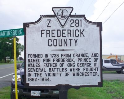
On Martinsburg Pike (U.S. 11) near the Virginia / West Virginia line, on the left when traveling north.
West Virginia. West Virginia was long a part of Virginia. Morgan Morgan began the settlement of the region in 1727. A great battle with the Indians took place at Point Pleasant, 1774. West Virginia became a separate state of the Union in . . . — — Map (db m193320) HM
On Northwestern Pike (U.S. 50) at Border Lane, on the right when traveling west on Northwestern Pike.
Frederick County Va. Area 435 Square Miles. Formed in 1738 from Orange and named for Frederick, Prince of Wales, father of King George III. Several battles were fought in the vicinity of Winchester 1862-1864.
West . . . — — Map (db m3097) HM
(Upper Plaque):This property has been place on the National Register of Historic Places (Lower Plaque):The Second of Two Lots Owned by John Kiger This Building Was A Blacksmith shop. Conestoga Wagons Were Made Behind This Building . . . — — Map (db m25786) HM
On North Loudoun Street at Rouss Avenue, on the right when traveling north on North Loudoun Street.
On July 24, 1758, at the first Frederick County Court House on this site, Colonel George Washington, age 26, was elected to the Virginia House of Burgesses. This was the first elective office of the young commander of Virginia's forces here to guard . . . — — Map (db m254474) HM
On 10 Mile Street at County Park Road, on the right when traveling east on 10 Mile Street.
Abraham (1718-1781) and Mary Parker Tegarden from Frederick County, Virginia 1753, made an 'improvement' opposite mouth of Tenmile Creek, Fayette County; Abraham, sutler for Colonel Bouquet 1759, fought in French and Indian War, Captain Virginia . . . — — Map (db m56944) HM
On Front Royal Pike (U.S. 522) at Lord Fairfax Highway (U.S. 340), on the right when traveling south on Front Royal Pike.
Clark County. Area 171 Square Miles. Formed in 1836 from Frederick and added to from Warren. Named for George Rogers Clark, conqueror of the Northwest. Lord Fairfax and General Daniel Morgan, Revolutionary hero, lived in this . . . — — Map (db m3481) HM
On North Washington Street (U.S. 522) 0.1 miles north of Legion Street, on the left when traveling north.
Born in 1840 in Frederick County, Virginia. O'Ferrall was appointed Morgan County clerk of the court at age 15 after the clerk, his father, died. In 1861, he enlisted in the Confederate cavalry as a private, rising to rank of colonel. Later, he . . . — — Map (db m196184) HM
(Upper Plaque):This Property has been placed on the National Register Of Historic Places (Lower Plaque):John B. Kiger well known wheelright lived in this unique log and stone house and built Conestoga wagons on this site in the 1830s. . . . — — Map (db m25725) HM
On Colonial Road (Local Route 605) at Lee Highway (U.S. 15/29), on the right when traveling east on Colonial Road. Reported permanently removed.
This crossroad is the ancient Dumfries-Winchester highway. Over it William Fairfax accompanied George Washington, then a lad of sixteen, on his first visit to Lord Fairfax at Greenway Court. It was on this occasion that Washington assisted in . . . — — Map (db m785) HM
On Martinsburg Pike (U.S. 11) at Brooke Road (Local Route 1322), on the right when traveling south on Martinsburg Pike.
In Mar. 1748, George Washington first visited Winchester, then known as Fredericktown, as a surveyor for Lord Fairfax. Washington purchased property in Winchester in 1753 and was an unsuccessful candidate for a House of Burgesses seat here in 1755. . . . — — Map (db m2663) HM
Near North G Street at West Belmont Street, on the left when traveling north.
Mary Lewis Willis was the granddaughter of Betty Washington, who was the only sister of George Washington. After moving here with her husband, who was a brick manufacturer, she died from yellow fever and was buried near her house in Cantonment. Her . . . — — Map (db m298499) HM
On Green Spring Road at Gibson Street SE, on the right when traveling north on Green Spring Road.
Black's Fort History
from History of Southwest Virginia, 1746-1786
Washington County 1777-1870
by
Lewis Preston Summers
In 1760, what was to become Abingdon received its first name, Wolf Hills, from Daniel Boone after his hunting party was . . . — — Map (db m210058) HM
On Race Street near West 4th Street, on the left when traveling north.
This mural depicts James Presley "J.P." Ball (1825-1904), a free Black man who overcame the racism of his time to become a renowned photographer in the pre-Civil War era, when slavery was still legal in the United States and
photography was a . . . — — Map (db m239195) HM
Patriot James Morgan was born April 5, 1748, in Frederick County, Virginia. At the age of 30, Morgan enlisted in the Revolution for a three-month tour in Colonel John Evan’s Virginia Regiment. He served with General McIntosh’s campaign in the Ohio . . . — — Map (db m31763) HM
Near Overfort Lane east of Pricketts Fort Road (County Route 72), on the right when traveling north.
Here lies buried
Colonel Zackeill Morgan
One of the earliest settlers of the old Monongalia County
Soldier of the Revolution
Founder of
Morgantown, (VA.) West Virginia, (1785)
Born (C) 1735 in Frederick County Virginia . . . — — Map (db m173501) HM
On Northwestern Pike (U.S. 50) near Gore Road (County Route 751), on the right when traveling west.
Here Willa Sibert Cather, the novelist, was born December 7, 1873. This community was her home until 1883, when her family moved to Nebraska. Nearby on Back Creek stands the old mill described in her novel Saphira and the Slave Girl. — — Map (db m92498) HM
Near North Main Street (U.S. 11) at West Court Street, on the left when traveling north.
Shenandoah County's native limestone courthouse was built in 1795 with brick additions in 1871 and 1886. In 1927, portico and columns were added giving the Federal Styled building a Greek revival front. It is the oldest courthouse in continuous use . . . — — Map (db m73774) HM
On Monocacy Boulevard south of Laurel Wood Way, on the right when traveling south.
"Where this letter will meet you, I am not able to ascertain, But ardently wish it May Be Near this place where your presence is absolutely necessary."
Lafayette letter to Anthony Wayne, May 15, 1781, near Richmond, . . . — — Map (db m303341) HM
On South 6th Street (County Route 2005) at Market Street (County Road 2004), on the left when traveling south on South 6th Street.
George Washington | 1732-1799
Known as the "Father of His Country," George Washington was the first president of the United States and the commander of the Continental Army who led the Patriots to victory during the american Revolutionary . . . — — Map (db m306919) HM
Under this spot repose the remains
of
Thomas, Sixth Lord Fairfax of Cameron
Son of Thomas, Fifth Lord Fairfax
and Cathrine Culpeper, his wife.
Born at Leeds Castle, County Kent, England,
October 22, 1693,
Died at his proprietary . . . — — Map (db m91900) HM
On Washington Street at Prospect Square, on the left when traveling west on Washington Street.
Center Plaque
On October 16, 1794, President George Washington arrived in Cumberland to review about 5,000 troops of the Maryland and Virginia militia gathered here during th Whiskey Rebellion. A few days later, this militia army assembled upon . . . — — Map (db m17456) HM
On South Main Street (State Highway 124), on the left when traveling south.
Near Reedy River Falls, stood the home, trading station, and grist mill of Col. Richard Pearis, first white settler of this section. He was a noted Indian trader and prominent Tory of the Revolution. — — Map (db m10428) HM
The Reedy is Greenville's river. Its flowing waters have nourished the city and its people for centuries, and its falls are the reason why Greenville is located where it is. But Greenville's people have not always been kind to the river, and now it . . . — — Map (db m31263) HM
The Cherokees
Greenville County was Cherokee Territory before the Revolution. European settlers were forbidden to live here until 1777, when Native Americans were forced to cede this land to the new state. Most of modern day Greenville was . . . — — Map (db m14535) HM
Near University Street. Reported permanently removed.
Richard Pearis settled near this site in 1776, and built a trading post and grist mill by the falls. This early settlement eventually became the City of Greenville. — — Map (db m182124) HM
On Falls Street near Camperdown Way (South Carolina Highway 124).
Richard Pearis, Greenville's first white settler, was an Irish adventurer who had settled in Virginia with his wife and family by the middle of the eighteenth century. He developed good trade relationships with the Cherokee Indians, had a son by an . . . — — Map (db m8035) HM
On Maple Street / North Frederick Pike (U.S. 522) at Autumn View Lane, on the right when traveling west on Maple Street / North Frederick Pike.
Thomas Fairfax (1693-1781), sixth Baron Fairfax of Cameron, was the proprietor of the Northern Neck Proprietary, a vast landholding that lay between the Rappahannock and the Potomac Rivers, and extended to the Blue Ridge. Born in England, he came . . . — — Map (db m2299) HM
On North Loudoun Street at Rouss Avenue, on the right when traveling north on North Loudoun Street.
Colonel James Wood, the founder of Winchester, was a native of the ancient city of the same name in England. He laid out and founded the new town prior to 1740. It received a charter of incorporation from the colonial legislature in February 1752. . . . — — Map (db m26892) HM
On Loudoun Street, on the right when traveling north. Reported permanently removed.
During the Civil War, the Union and Confederate armies each used the Frederick County Courthouse as a hospital and a prison. Cornelia McDonald, a local citizen, nursed the wounded here after the First Battle of Kernstown on March 23, 1862. She . . . — — Map (db m2659) HM
On Loudoun Street near Peyton Street, on the right when traveling south.
Built by George Washington in 1756 Home and Seminary of Katherine Glass Greene Organizing regent of Fort Loudoun Chapter NSDAR - 1921 Presented by the chapter on its 75th Anniversary 1996 — — Map (db m89907) HM
Near North G Street at West Belmont Street, on the left when traveling north.
Born June 24, 1782 Frederick County, Virginia Died October 7, 1834 Pensacola, Florida Granddaughter of Betty Washington who was the only sister of George Washington Mary W. Willis was also the mother of Princess Catherine D. Murat of the Court of . . . — — Map (db m298500) HM
On North Kent Street north of Liberty Avenue, on the left when traveling north.
When Ray Charles came to town, the good times rolled. In the late 1930s, 1940s, and 1950s, this brick building was Finley's Recreation Center, a dance hall that brought some of the soon-to-be-famous Black musicians to perform for Black audiences. . . . — — Map (db m273691) HM
On East Lane at East Boscawan Street, on the right when traveling north on East Lane.
To the Glory of God and in Memory of Lutheran Pioneers. Erected by members and friends of Grace Evangelical Lutheran Church Winchester, Va. 1938. These walls are the sacred ruins of the first Lutheran Church erected in Winchester - "Die teutsche . . . — — Map (db m26857) HM
On North East Lane at East Piccadilly Street, on the right when traveling north on North East Lane.
Fought everywhere, was beaten nowhere.
Major General Daniel Morgan Response Letter to Congress, c. 1798
The Epitaph on Daniel Morgan's original grave marker at this site: Major General Daniel Morgan
On July 6th, 1802 in the 67th year of . . . — — Map (db m4740) HM
On Shepherdstown Road (West Virginia Route 45) at Files Cross Road (Local Route 45/2), on the left when traveling east on Shepherdstown Road.
1.5 miles north is Swan Pond Manor, a 2,000 acre retreat set aside in 1745 for use by Thomas, Lord Fairfax, once the proprietor of the Northern Neck of Virginia who established an estate at Greenway Court, Frederick County in 1738. So named because . . . — — Map (db m92579) HM
Major James Gibson
Son of Andrew Gibson and Sarah Hopkins,
was born August 10, 1776, at
Lancaster, Penna. Came to
Winchester, Virginia with
his parents in 1779.
Commissioned by
Governor Cabell in 1807
Captain of Hampshire . . . — — Map (db m103494) HM WM
On Middleway Pike (West Virginia Route 51) east of North Ridge Drive. Reported missing.
This chapel was built by devout people of (then) Frederick Parish. Frederick County, Virginia joined Col. Robert Worthington in completing it in 1769. It was first called the English Church, then Berkeley Church, then Norborne Chapel, as the parish . . . — — Map (db m2026) HM
On Broadway at Missouri Street, on the right when traveling west on Broadway.
James Todd Dean, the only child of Irish immigrants, was born in Philadelphia, PA. James' mother died when he was less than a year old. James' father then married his deceased wife's sister who raised him. James father, James, was a carpenter by . . . — — Map (db m249155) HM
On Poplar Street east of S 5th Street, on the right when traveling east.
Early settlers of Johnson County included patriots of the Revolutionary War. With this Historical Marker we commemorate the following veterans.
Daniel Chapman - Born July 25, 1756 in Westchester County, New York. Daniel Chapman served the . . . — — Map (db m146585) HM WM
On West Main Street west of South 1st Avenue, on the right when traveling east.
Oldham was the 75th county created by the Kentucky Legislature. It was formed on January 15, 1824, from portions of Jefferson, Henry and Shelby Counties. The county is named for William Oldham, Revolutionary War patriot and early pioneer.
. . . — — Map (db m136163) HM
Frederick County. Named for Frederick 5th and last Lord Baltimore. Erected out of Prince George’s County in 1748. It then included Montgomery County and all of Maryland west to the West Virginia boundary.
Washington County. The first . . . — — Map (db m41770) HM
Near Amherst Street (U.S. 50) at Whittier Avenue, on the left when traveling west.
This site, known as Glen Burnie, is the homestead of Col. James Wood, who founded Winchester on a portion of his land in 1744. Wood’s son, Robert, began the present house in 1793, but the estate was home to the Wood-Glass families from the 1730s to . . . — — Map (db m142560) HM
On East John Street east of South Water Street, on the right when traveling west.
Adam Stephen (1720-1791) had a close acquaintance with George Washington through their association with Lord Fairfax and from their military involvements from the French & Indian War through the American Revolution. Stephen was present with . . . — — Map (db m167507) HM
The limestone barracks in front of you, built in 1778, is among the oldest and most important surviving American military structures in the nation. The barracks consisted of two L-shaped buildings, but only the eastern wing remains today. During the . . . — — Map (db m103369) HM
On Wardensville Pike / John Marshall Highway (Virginia Route 55) at Star Tannery Road (County Route 604), on the left when traveling west on Wardensville Pike / John Marshall Highway.
Frederick County. Area 485 Square Miles. Formed in 1738 from Orange, and named for Frederick, Prince of Wales, Father of King George III. Several battles were fought in the vicinity of Winchester, 1862–1864.
Shenandoah . . . — — Map (db m9251) HM
On North Kent Street at Elk Street on North Kent Street.
This old stone house was for many years the homeplace of the Evans family. William Armstead "Shug" Evans, a free Black, came to Winchester from southern Virginia before the Civil War. He first operated a stage line from Winchester south to Strasburg . . . — — Map (db m273781) HM
On Greenwood Road at Senseny Road, on the right when traveling north on Greenwood Road.
Public education began in Frederick County during the last decades of the 19th century. This marks the beginning of the public education system, as mandated by the Underwood Constitution. During the period the school district included three . . . — — Map (db m274605) HM
Near Jones Road (County Route 621) 0.4 miles south of Cedar Creek Grade ( Route 622), on the left when traveling south. Reported permanently removed.
As Southern units retreated and resistance fell apart, Northern victory was assured.
Jackson found himself surrounded by a disorderly retreat of his soldiers. In the growing dark, a few fresh Southern units made gallant attempts to cover the . . . — — Map (db m254534) HM
Near Jones Road (Virginia Route 621) 0.4 miles south of Cedar Creek Grade ( Route 622), on the left when traveling south.
In the evening of March 23, 1862, "Stonewall" Jackson found himself surrounded by a disorderly retreat of his soldiers. In the growing dark, a few fresh Southern units made gallant attempts to cover the Southern retreat from Northern pursuit. One . . . — — Map (db m310385) HM
On Battle Park Drive 0.3 miles west of Saratoga Drive, on the right when traveling west.
Three generations of the Pritchard family utilized enslaved labor in their farming and business ventures from at least as early as 1778 to the time of the Civil War. Stephen Pritchard, Sr. (1745-1819) and his son Stephen Jr. (1776-1858) each held . . . — — Map (db m259965) HM
On Remount Road (U.S. 522), on the right when traveling south.
Warren County. This lower Shenandoah Valley county was formed from Shenandoah and Frederick Counties in 1836. The county was named for Joseph Warren, a Boston Revolutionary War patriot killed during the Battle of Bunker Hill in 1775. It . . . — — Map (db m49779) HM
On John Marshall Highway (Virginia Route 55) at Freezeland Road ( Route 638), on the right when traveling west on John Marshall Highway.
Warren County. Warren County was named for Joseph Warren, the revolutionary patriot who sent Paul Revere and William Dawes on their famous rides and who was killed at the Battle of Bunker Hill. The county was formed from Shenandoah and . . . — — Map (db m1324) HM
On Valley Pike (U.S. 11), on the left when traveling south.
Frederick County. Area 485 Square Miles. Formed in 1738 from Orange, and named for Frederick, Prince of Wales, Father of King George III. Several battles were fought in the vicinity of Winchester, 1862-1864.
Shenandoah . . . — — Map (db m3430) HM
On South Braddock Street (U.S. 11) at Wolfe Street, on the right when traveling south on South Braddock Street. Reported permanently removed.
"To Serve the Present Age" - Charles Wesley From Court House to Church Thirty-two charter members met July 24, 1858, in the Frederick County Court House and were organized as a congregation of the Methodist Episcopal Church, South, . . . — — Map (db m7342) HM
On North Queen Street (U.S. 11) north of Cloud Street, on the right when traveling north.
400 Yards West of This Spot Is The Red House
The Home of Edward Beeson
Where the County of Berkeley was Founded
From a Part of Frederick County, Virginia
May 19, 1772
And Where the First Country Court was . . . — — Map (db m243836) HM
Near Kearneysville Pike (West Virginia Route 480) at Starkey's Landing, on the left when traveling south.
Near this site in July 1775, then part of Berkeley County , Va., two companies of riflemen, led by Captains Hugh Stephenson of Berkeley County and Daniel Morgan of Frederick County, Va. rallied prior to their 600-mile journey to join General . . . — — Map (db m278124) HM
Near Overlook Trail 4.6 miles south of Middle Fork Cabin Lane, on the right.
Cacapon Mountain, where you are standing, is the westernmost of the pair of north/south mountains that mark the region as belonging to the ridge and valley section of the Appalachians. Looking out from the overlook, you see its eastern . . . — — Map (db m156764) HM
Cedar Creek Battlefield and Belle Grove has been designated a Registered National Historic Landmark under the jurisdiction of the Historic Sites Act of August 21, 1935. This site possesses exceptional value in commemorating or illustrating the . . . — — Map (db m92700) HM
Author of History of The Valley of Virginia
1st Edition Printed in Winchester 1833
Born Frederick County now Clarke County
He is buried here in the Bowman Graveyard
Harmony Hall — — Map (db m36723) HM
Near E Street Southeast east of Potomac Avenue Southeast, on the right when traveling east.
Born in 1755 in Virginia, Mountjoy Bayly moved to Western Maryland in his youth. He was serving as an officer in the Maryland Militia when the Revolutionary War began in 1775. He fought in several battles in 1776, including Harlem Heights and Ft. . . . — — Map (db m266029) HM
On Main Street (Maryland Route 31) at Green Valley Road, on the left when traveling east on Main Street.
In June 1864, Confederate Gen. Robert E. Lee sent Gen. Jubal A. Early's corps from the Richmond battlefields to the Shenandoah Valley to counter Union Gen. David Hunter's army. After driving Hunter into West Virginia, Early invaded . . . — — Map (db m201629) HM
On East Church Street at East Market Street ( Route 355), on the right when traveling east on East Church Street.
The building in front of you, Kemp Hall, was the capitol of Maryland during the spring and summer of 1861, as the state came perilously close to leaving the Union. Because secession would have placed the U.S. capital, Washington, D.C., between . . . — — Map (db m249967) HM
On East Church Street at North Market Street, on the right when traveling east on East Church Street. Reported permanently removed.
The building in front of you, Kemp Hall, was the capitol of Maryland during the spring and summer of 1861, as the state came perilously close to leaving the Union. Because secession would have placed the U.S. capital, Washington, D.C. between the . . . — — Map (db m67247) HM
On 3 February 1941, President Franklin D. Roosevelt issued a decree calling the 29th Infantry Division into active service for one year, which became five. Responding to that call, National Guardsmen from Frederick County, Virginia, and nearby areas . . . — — Map (db m241467) HM WM
On Martin Street (Local Route 1001) east of Grove Street (Local Route 1011), on the right when traveling west.
Here, next to Locust Grove Cemetery, stood a school the entire community sponsored. It was a "Rosenwald School." To qualify for a Rosenwald grant, African Americans had to raise additional money, and in Stephens City they did. With public funding . . . — — Map (db m258535) HM
On Millwood Pike (U.S. 17 / 50) at Front Royal Pike (U.S. 522), on the right when traveling west on Millwood Pike.
General Daniel Morgan. Morgan used this road in traveling from his home, “Saratoga,” to Winchester. He was a frontiersman, Indian fighter and the commander of Morgan’s famous riflemen in the Revolution. He won glory at Quebec and Saratoga, . . . — — Map (db m2290) HM
On North Washington Street (U.S. 522) at Fairfax Street on North Washington Street.
Frederick Conrad
Lot #68
Frederick Conrad, a tanner from Frederick County, Va. Conrad also bought Lot #75 which adjoins this lot.
Lot #68: Conveyed by the Trustees of the Town of Bath to Frederick Conrad, August 19, 1777. . . . — — Map (db m117408) HM
Near Jones Road (Virginia Route 621) 0.6 miles south of Cedar Creek Grade ( Route 622), on the right when traveling north.
When the First Battle of Kernstown took place, William Wood Glass was living on this farm. Just two months earlier, he had been discharged for health reasons after serving in the 51st Regiment, Virginia Militia under "Stonewall" Jackson. The . . . — — Map (db m185091) HM
On North Loudoun Street north of East Boscawen Street, on the right when traveling north.
"The courtroom is a hospital, in which every variety of wound and suffering meets your eye." —Union Col. Wilder Dwight after the First Battle of Kernstown, March 23, 1862
Directly in front of you stands the historic . . . — — Map (db m290261) HM
These barracks served as the first public building for the new state. Founded in 1777, the limestone twins stood tall two years later, thanks to contractor Abraham Faw and local craftsmen. Set atop strategic ground, the Barracks controlled the . . . — — Map (db m103418) HM
This site marks important advances in the history of military medicine. Here Army doctors, nurses, and Daughters of Charity shaped its practice in modern form. Caregivers treated at this 18 acre complex over 30,000 sick and wounded soldiers, Union . . . — — Map (db m103419) HM
On Academy Street west of Lord Fairfax Highway (U.S. 340), on the right when traveling west.
In memory of
1746 James Ireland 1806
Minister of the Gospel
Born in Edinburgh, Scotland and converted in Frederick County, Va.
Baptized and ordained at Sandy Creek, N.C. Imprisoned at Culpeper,
Va. for preaching the gospel organizer . . . — — Map (db m221644) HM
Thin black lines indicate changes in relevance. Between each pair of lines entries are ordered geographically but all have the same relevance.
* Inflectional forms of words are their plurals, singulars, and possessives as well as gramatical tenses and similar variations.