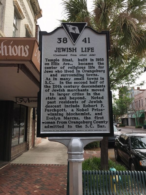
On Russell Street (State Highway 33) east of Broughton Street (Business U.S. 178), on the left when traveling east.
(side 1)
Jewish Merchants
Russell St., historic hub of Orangeburg's commercial life, was home to Jewish merchants for over 160 years. German Jews began settling in Orangeburg in the 1830s, followed in the next century by Eastern . . . — — Map (db m103381) HM
On Callejón San Sebastián just north of Calle de Chajón, on the left when traveling north.
De los 6 millones de Judíos asesinados durante el Holocausto, entre 1939 a 1945, 1.5 millones eran niños. Ana Frank fue una entre todos ellos. “A pesar de todo, sigo creyendo que las personas son realmente buenas de corazón”. Ana Frank . . . — — Map (db m190723) HM WM
On Liverpool Street at Old Broad Street, on the right when traveling west on Liverpool Street.
In gratitude to the people of Britain for saving the lives of 10,000 unaccompanied mainly Jewish children who fled from Nazi persecution in 1938 and 1939.
“Whosoever rescues a single soul is credited as though they had saved the whole . . . — — Map (db m117258) HM
Jews have been part of the social, economic and cultural life of Iowa since the early 19th century. It was not until 1855 that the Jewish population in Keokuk grew large enough to establish a religious community, Congregation B’nai Israel ( . . . — — Map (db m27084) HM
On East Lombard Street just east of South Gay Street, on the left when traveling east.
Recalling the elaborate rail system used during the Holocaust to transport millions of people to their deaths, the concrete monoliths symbolize two abandoned rail cars. Haunting messages, written by a survivor, are the only freight these rail . . . — — Map (db m183360) HM WM
On South Commerce Street at Washington Street, on the left when traveling south on South Commerce Street.
Jewish Americans have been part of Mississippi’s economic, social and political life since the 1780’s. In 1843, the Jewish community of Natchez grew large enough to organize and sustain the state’s first permanent religious congregation, Temple . . . — — Map (db m79345) HM
On Harney Street east of South 24th Street, on the right when traveling west.
Jews have been part of Nebraska’s social, economic and political life since the mid 1800’s.
It was not until 1871 that the small Jewish community in Omaha grew large enough to organize and formally found Congregation of Israel.
On Sept. . . . — — Map (db m40743) HM
Jews have lived in Oklahoma since the mid 19th century. In 1903, Jews in Oklahoma City organized Temple B'Nai Israel. During its first few years, the congregation met at several local churches. The synagogue, located at 50 Broadway Circle, was . . . — — Map (db m134144) HM
On Whaley Street at Marion Street on Whaley Street.
In 1883 members of Columbia’s Jewish community founded the Hebrew Cemetery Society of Columbia as an alternative to the Hebrew Benevolent Society’s cemetery, which had been established in 1822. The organization purchased a 4-acre tract bounded by . . . — — Map (db m123490) HM
On Marion Street at Blanding Street on Marion Street.
In 1905 disagreements over religious practices divided members of Columbia’s Tree of Life Synagogue. Jews embracing Orthodoxy formed a new synagogue, which they named Beth Shalom (House of Peace). Meetings were held in a private home on the corner . . . — — Map (db m123492) HM
On Woodrow Street at Heyward Street, on the right when traveling north on Woodrow Street.
In 1896 members of 18 Jewish families assembled to worship at the Independent Fire Company’s station overlooking Sidney Park. Organized as Etz Chayim (Tree of Life), this group’s members embraced Judaism’s Reform branch or liberal movement. In 1907, . . . — — Map (db m123491) HM
On Central Avenue at Chestnut Street, on the left when traveling north on Central Avenue.
Chestnut Street Cemetery. Chestnut Street Cemetery is the first Jewish cemetery in Ohio and the earliest west of the Allegheny Mountains. It was established in 1821 when Nicholas Longworth sold land to Joseph Jonas, David I. Johnson, Morris . . . — — Map (db m243113) HM
(Hebrew name and date of death not transcribed, but translates to:)
Reb' Chaim Tuvia the son of Yehudah Leib, died 18th of Iyar, 5737
Remembering
Kurt Theodor Goldschlager
Served in No. 3 Jewish Troop 10 Commando WW2
as . . . — — Map (db m201592) HM
"Set up for yourself roadmarks...the way by which you went. Return, O virgin of Israel" Jeremiah 31:21
Nearly 70 Jewish immigrants were settled in and near Cotopaxi. Facing insurmountable challenges, the ill equipped . . . — — Map (db m134127) HM
After construction of a railroad line South from Roseburg in 1881-1883, Solomon Abraham, the local right of way agent, platted the community and named it Julia after his wife. After a dispute with Abraham, A.F. Morris, the Chief Engineer for the . . . — — Map (db m134058) HM
Delaware’s first Jewish farmers, Isaac and Ida Beinoff, settled here in 1897. Like those to follow, they were recent immigrants fleeing poverty and oppression in their native Russia. Between 1912 and 1929, the Jewish Agriculture Society, based in . . . — — Map (db m142529) HM
August Bondi was born July 21, 1831, in Vienna, Austria. The Bondis, Jewish European refugees, fled the Austrian Empire after the failed revolutions of 1848 and settled in St. Louis, Missouri. August Bondi moved to Pottawatomie Creek in Franklin . . . — — Map (db m134060) HM
On Main Street at Exchange Street, on the right when traveling south on Main Street.
Jews have been part of Tennessee’s economic, social and political life since the late 18th century. Congregation Children of Israel, chartered by the State of Tennessee, March 2, 1854, rented and eventually purchased a building near this site at . . . — — Map (db m84648) HM
Im Jahre 1933 lebten in Hamburg 24.000 Juden.
Hier begann der Weg tausender jüdischer Bürger Hamburgs, der in den Vernichtungslagern des Nazi-Regimes endete.
[English translation:]
In 1933, 24,000 Jewish . . . — — Map (db m140236) HM
One of the stones in the wall, bears a Hebrew inscription "and you shall see and your heart shall rejoice and their bones like grass shall..." - a biblical verse somewhat altered.. The circumstances of the inscription are unknown.
(Hebrew . . . — — Map (db m219240) HM
On Ha-Yehudim Street, on the left when traveling south.
In the course of the reconstruction of the Jewish Quarter the 1970s, archaeological finds dated to different periods include numerous architectural elements. These were found throughout the Jewish Quarter in secondary use in later structures, and . . . — — Map (db m220137) HM
On Ha-Yehudim Street, on the left when traveling south.
From the 7th century CE, Jerusalem's architectural tradition continued to develop, while utilizing earlier traditions and reusing architectural elements. Over the years new architectural and artistic styles appeared. one of the innovations was the . . . — — Map (db m220135) HM
On Ha-Yehudim Street, on the left when traveling south.
During 1930-1948 the grocery store of brothers Avraham and Ben-Zion Maimaran operated in this building. Both were born in the Jewish Quarter to one of its oldest families.
The store served as a social and commercial center. In 1948 it became a . . . — — Map (db m219070) HM
On Ha-Yehudim Street, on the left when traveling south.
Commander of the Jewish Quarter in Israel's War of Independence in 1948 and named "Worthy of Jerusalem." The City of Jerusalem and his comrades in arms have chosen this site to commemorate their commander Moshe Rusnak.
Who with wisdom and faith, . . . — — Map (db m220138) WM
Collapsed on the paved street are stones of the western wall of the Temple Mount enclosure. They were hurled down by the soldiers of the Roman Legion after the destruction of the Temple on the ninth day of the month of Av, 70 CE.
(Hebrew and . . . — — Map (db m219242) HM
This is a Second Temple period home that was situated in the opulent Herodian Quarter. Excavations revealed burnt wooden beams and soot. Apparently it burned down in the great fire the Romans started in Jerusalem after the Temple's destruction (70 . . . — — Map (db m219153) HM
The University of North Carolina at Charlotte has been conducting archaeological excavations at this location for more than a decade, with the discovery of the remains of a major multi-roomed structure from the Second Temple period (late 1st century . . . — — Map (db m220181) HM
The Foundation Stone sits at the peak of Mount Moriah above the Western Wall. According to tradition, the world was created from this stone, the Binding of Isaac took place on it, and King Solomon built the First Temple around it as "a house for the . . . — — Map (db m221891) HM
A pier of large stones which originally supported the western springer of Robinson's Arch. The pier enclosed four cubicles that served as shops, opening onto the paved street.
(Hebrew and Arabic not transcribed) — — Map (db m219239) HM
Among the collapsed stones was one (its replica displayed here), which bore a Hebrew inscription: "to the place of trumpeting to...". In the Second Temple days this stone probably marked the place - at the top of the southwest corner of the Temple . . . — — Map (db m219238) HM
On Ha-Yehudim Street, on the left when traveling south.
During the Roman and Byzantine periods alongside the continued use of local limestone the use of marble in construction became widespread, particularly in public buildings. The display contains architectural elements that decorated public buildings . . . — — Map (db m219114) HM
On Ha-Yehudim Street, on the left when traveling south.
Sons of the 'Old Yishuv' in Jerusalem typically studied Torah from a young age. Following many years of study, as adult men, they would train to become either a scholar or a professional.
Daughters were destined to be wives and mothers, and . . . — — Map (db m219121) HM
"And Eternal Life He has implanted within us" (blessing on reading the Torah).
This is the original site of Old Jerusalem's largest yeshiva. All age groups - from young children to the elderly - have studied here since 1876.
The yeshiva . . . — — Map (db m220117) HM
On Ha-Yehudim Street, on the left when traveling south.
On November 29, 1947, the War of Independence broke out and the battle for the Old City of Jerusalem lasted 180 days. The early stages of the war were characterized by localized Arab attacks in full view of the unresponsive British Army. When the . . . — — Map (db m219151) HM
This was one of the most important Sephardic yeshivot in Jerusalem. The cornerstone was laid in 1914. Its grand inauguration took place in 1923.
During the War of Independence (1948), the building served as a frontline position for the besieged . . . — — Map (db m219155) HM
Remains of Jerusalem's main street, running the length of the Western Wall along about one kilometer, in the late Second Temple period. The street was paved with flagstones and edged with curbstones. It had two large drainage channels running . . . — — Map (db m219237) HM
On Misgav Ladakh Street, on the left when traveling south.
The Order of the Teutonic Knights settled here during the Crusader Period (12th-13th centuries CE). The Order built the Church of St. Mary and a hospital, which were destroyed; and St. Mary's Hospice of the German Knights, whose ruins you see before . . . — — Map (db m220119) HM
On Ha-Yehudim Street, on the left when traveling south.
Until the sixteenth century, the "Ramban" was the main synagogue, where members of all denominations prayed together. Its closure at the end of that century is probably the point at which the various streams dispersed. The Sephardi Jews organized in . . . — — Map (db m219150) HM
On Misgav Ladakh Street, on the right when traveling south.
The Crusaders built a roofed market on the remnants of the Byzantine Cardo. In the ensuing years, the vaulted ceilings became the cellars of buildings above. The market was renovated after the Six Day War (1967).
Photo caption: Capital of a . . . — — Map (db m220120) HM
On Ha-Yehudim Street, on the left when traveling south.
In the mid-19th century, the waves of Jewish immigration increased, and the Ashkenazi community grew rapidly. On September 25, 1864, the great Hurva synagogue was inaugurated in an inspiring ceremony Just in time for the High Holidays. Ceremony . . . — — Map (db m219118) HM
You are facing the remains of a lower aqueduct originally built in the Hasmonean period. During the second temple period the need to bring water to Jerusalem increased. This serpentine aqueduct was 21 km (13.5 miles) long; it began, at Solomon's . . . — — Map (db m219171) HM
On Ha-Yehudim Street, on the right when traveling south.
Remains of a magnificent main road from the Roman-Byzantine period serving throughout time until today as a major thoroughfare for shopping.
(Arabic and Hebrew text not transcribed) — — Map (db m219069) HM
On Carrer de l'Arc de Sant Ramon del Call at Carrer del Call on Carrer de l'Arc de Sant Ramon del Call.
(Catalan:)
Segueix la línia interior del mur romà.
No tenia sortida
al carrer del Call, i,
per un pont elevat,
es comunicava directament amb el
Castell Nou, una
fortalesa medieval
construïda sobre la
porta romana. . . . — — Map (db m142352) HM
On Carrer de Sant Domènec del Call at Carrer de Salomó ben Adret on Carrer de Sant Domènec del Call.
(Catalan:)
Carrer principal del
Call, on es concentraven la Sinagoga
Major, la carnisseria
i les cases dels membres més importants
de la comunitat.
En un extrem hi havia
el portal d'accés al barri.
- . . . — — Map (db m142358) HM
On Carrer de Sant Honorat, on the left when traveling west.
(Catalan:)
El Call Major.
Barri jueu medieval,
segles XII-XIV
Carrer de
Sant Honorat
Límit est del barri.
A l'extrem hi havia
un dels portals
d'accés al Call i, en
un carreró ara
desaparegut, la font,
la . . . — — Map (db m141496) HM
On Carrer de Sant Sever at Carrer de Salomó ben Adret on Carrer de Sant Sever.
(Catalan:) Límit nord del Call.
A la dreta limitava
amb els dominis
episcopals i a
l'esquerra estava
tallat pel mur romà.
No s'obrí fins a final
del segle XIV, vers el
carrer de la Palla.
. . . — — Map (db m142359) HM
On Placeta de Manuel Ribé at Carrer de Salomó ben Adret on Placeta de Manuel Ribé.
(English:)
Modern square in
the centre of the old
Call.
The Call was the
quarter inhabited by
the Jewish community in medieval
Barcelona. The word
Call means narrow
street. The community was called Aljama and . . . — — Map (db m141161) HM
Remembering Austrian Jewish Artist
Albert Reuss
and his devoted wife
Rosa nee Feinstein
who fled Vienna to England in 1938
to escape the Nazi Holocaust.
They moved to Mousehole in 1948.
Because of Rosa's love . . . — — Map (db m206534) HM WM
On Oakleigh Road North, on the right when traveling east.
Awarded the George Cross for courage in defusing a landmine in Garston, Liverpool. He was a Club Leader at the Oxford and St. George's Youth Club in Enriques Street, Whitechapel, which subsequently re-located to this site.
Be strong and of . . . — — Map (db m231042) HM
Leopold (Leo) Samuel Marks, MBE lived flat 410 Park West,
when Chief of Codes at Special Operations Executive (SOE) in WW2. He was a key trainer of secret agents sent to defeat the Nazis.
Set a watch before my mouth Lord:
and over the . . . — — Map (db m205212) HM
On Lauriston Road, on the right when traveling north.
British Secret Agent for the Special Operations Executive (SOE), born and brought up in Hackney. Deployed to Corsica and France on two missions, he was betrayed then murdered by the Nazis at the Gross Rosen death camp in 1944.
He has no known . . . — — Map (db m231217) HM WM
On Government Street, on the right when traveling south.
Jews have been part of Alabama’s economic, social and political life since 1764. It was not until 1841 that Mobile’s small Jewish community grew large enough to organize “Congregation” Shaarai Shomayim (Gates of Heaven). The community . . . — — Map (db m27083) HM
Buried here are the remains of Tom McLaury, Frank McLaury, Billy Clanton - killed in Earp Clanton battle Oct 26, 1881.
Dan Dowd, Red Sample, Bill DeLancy, Dan Kelly: Tex Howard hanged legally by Sheriff Ward for Bisbee massacre Mar 1884, John . . . — — Map (db m100173) HM
On President Clinton Avenue, on the right when traveling east.
From 1882 to 1887, an ornate two-story space on the second floor of this building served as the social hall for the Concordia Association – an organization established in 1864 to help Jewish immigrant families adapt to their new lives in . . . — — Map (db m78014) HM
On G Street Northwest at 3rd Street Northwest, on the left when traveling east on G Street Northwest. Reported missing.
“The neighborhood
was our whole life.”
Albert Small, born in the neighborhood in 1902.
This is the oldest surviving synagogue building in Washington. Constructed in 1875 by Adas Israel Congregation, and . . . — — Map (db m29761) HM
On Delaware Street near 3rd Street, on the left when traveling east.
Leavenworth - Gateway to the West and Headquarters of the Department of the Missouri - was the supply base for settlers and emigrants to the vast region lying west to the Pacific Ocean. Selected because of the excellence of its site, the . . . — — Map (db m50902) HM
During the early morning hours of February 3, 1943, the USAT Dorchester was part of a convoy of six ships heading for Greenland when an enemy u-boat attacked, firing a torpedo into the ship's midsection. The Dorchester quickly began taking on water . . . — — Map (db m41887) HM
On Patton Avenue, on the left when traveling west.
Every town has its legendary businesses and The Man Store was certainly one of those. Most people who lived in or anywhere near Asheville from 1922 until the store left downtown in the early 1970s were familiar with it. Coleman Zageir (1894-1975) . . . — — Map (db m210017) HM
Since the territorial days of 1870's, Jewish people have played an important role in the social, economic and cultural life of South Dakota. In the 1880's, Sioux Falls experienced an influx of Reformed Jews from Germany, who became some of the . . . — — Map (db m134205) HM
On West Broadway just west of West Temple, on the right when traveling west.
Jews have been part of Utah’s religious, economic, social, and political life since the mid-19th century. Congregation B’Nai Israel was organized in 1874. The first service was held in March, 1883. B’Nai Israel merged with Congregation Montefiore in . . . — — Map (db m35792) HM
On Rotan Street (Local Road 19/15) at Austin Street and King Avenue, on the right when traveling south on Rotan Street.
At the top of the hill here a community came together to help Jewish soldiers
keep their faith in the midst of war. In early April 1862, Pvt. Joseph A. Joel
and 20 other Jewish soldiers in the 23rd Ohio Infantry asked Col.
Rutherford B. Hayes, a . . . — — Map (db m223876) HM
On Pioneer near 20th Street, on the left when traveling east.
The first Permanent Jewish Synagogue in Wyoming was erected in 1915 by Cheyenne’s Mt. Sinai Congregation. German Jewish merchants came to Cheyenne starting in 1867, organized but were unable to build a Synagogue. After 1900, with the arrival of . . . — — Map (db m27087) HM
On Hoxton Street near Falkirk Street, on the right when traveling north.
On the site of this College, formerly Shoreditch and Hoxton Schools, once
stood the Hoxton Jewish cemetery, burial ground of the old Hambro Synagogue
in the City, from 1707 till 1960. The remains were transferred to the West Ham
Jewish . . . — — Map (db m229343) HM
On Main Street at Wall Street, on the right when traveling south on Main Street.
Jewish American pioneers significantly contributed to the commercial development and establishment of responsible government in Deadwood. For example, gritty Jewish westerner, Sol Star, arrived in Deadwood in 1876 with his business partner Seth . . . — — Map (db m183220) HM
On Terliststraat, on the right when traveling north.
Gedenkplaat
Ter nagedachtenis van de joodse stadsgenoten die
door de nazi's met geweld in dit gebouw verzameld
werden om op zaterdag 29 augustus 1942 naar de Kazerne
Dossin vervoerd te worden.
Vandaaruit werden zij . . . — — Map (db m229885) HM WM
On Rue Vaucanson, on the right when traveling north.
De 1942 à 1944, plus de 11000 enfants
furent déportés de france par les nazis avec la participation active du Gouvernement
Français de Vichy et assassinés
dans les camps de la mort parce que nés juifs. Plus de 500 de ces enfants . . . — — Map (db m234062) HM WM
On Rue de Saussure, on the right when traveling north.
A la mémoire des élèves de cette école
déportés de 1942 à 1944 parce que nés juifs
victimes innocentes de la barbarie nazie
et du gouvernement de Vichy.
Ils furent exterminés dans les camps de la mort
Plus de 80 de ces enfants . . . — — Map (db m246273) WM
On Rue Buffault, on the left when traveling south.
En memoire
de douze mille enfants juifs
deportes de france entre 1942 et 1944
arretes dans les ecoles,
dans leurs foyers et dans les rues
morts a auschwitz ou ailleurs.
Que leur sacrifice demeure vivant pour tous
et a . . . — — Map (db m240336) HM WM
On Rue Buffault, on the left when traveling south.
A la mémoire des élèves de cette école,
déporteés de 1942 a 1944 parce que nées juives,
victimes innocentes de la barbarie nazie
et du gouvernement de Vichy.
Plus de 300 enfants du 9ème Arrondissement
ont été exterminés dans les . . . — — Map (db m240337) HM WM
De 1942 à 1944, plus de 700 enfants juifs
demeurant dans le 10ème arrondissement
furent déportés dans les camps d'extermination.
Parmi eux, 75 tout-petits furent arrachés à
leur famille et sont morts sans sépulture.
Afin d'honorer . . . — — Map (db m214803) HM WM
Arrétés par la police du Gouvernement de Vichy, complice du l’occupant nazi, plus de 11400 enfants furent déportés de France de 1942 à 1944 et assassinés dans les camps de extermination parce qu’ils étaient nés juifs.
Plus de 700 . . . — — Map (db m214850) HM WM
On Rue de la Jussienne, on the left when traveling north.
A la mémoire des élèves de cette école
déportés de 1942 a 1944 parce que nés juifs,
victimes innocentes de la barbarie nazie
avec la complicité du gouvernement de Vichy.
Ils furent exterminés dans les camps de la mort.
140 . . . — — Map (db m214798) HM WM
On Rue Blanche, on the right when traveling south.
A la mémoire des élèves de cette école,
déportés de 1942 a 1944 parce que nés juifs, victimes innocentes de la barbarie nazie
et du Gouvernement de Vichy.
Plus de 300 enfants du 9ème Arrondissement ont été extermines dans les . . . — — Map (db m240586) HM WM
À la mémoire des enfants, élèves de cette école,
déportés de 1942 à 1944 parce qu'ils étaient nés juifs,
victimes innocentes de la barbarie nazie
avec la complicité active du gouvernement de Vichy.
Plus de 11400 enfants furent . . . — — Map (db m231370) HM WM
On Avenue Circulaire, on the right when traveling west.
1942 - 1945
A la memoire des enfants juifs asassines par les nazis
Passant, ta memoire est leur seule sepulture
(English translation:)
In memory of the Jewish children murdered by the Nazis.
In passing, your memory is . . . — — Map (db m246157) WM
On Rue Boulard, on the right when traveling south.
A la mémoire des élèves de cette école,
déportés de 1942 a 1944 parce que nés juifs, victimes innocentes de la barbarie nazie avec la complicité du gouvernement de Vichy.
Ils furent exterminés dans les camps de la mort. Plus de 120 . . . — — Map (db m246166) WM
On Boulevard Malesherbes, on the right when traveling south.
A la mémoire des élèves de ce lycée
déportés de 1942 a 1944 parce que nés juifs, victimes innocentes de la barbarie nazie avec la complicité du gouvernement de Vichy.
Ils furent exterminés dans les camps de la mort. Plus de 80 de . . . — — Map (db m244696) WM
On Rue de Chabrol, on the right when traveling east.
A la mémoire des élèves de ce groupe scolaire déportés de 1942 a 1944 parce que nés juifs, victimes innocentes de la barbarie nazie et du gouvernement de Vichy.
Ils furent exterminés dans les camps de la mort.
Plus de 500 de ces . . . — — Map (db m231001) WM
A la mémoire des élèves du cette école, déportés de 1942 a 1944 parce que nés juifs, victimes innocentes de la barbarie nazie et du gouvernement de vichy.
Plus de 300 enfants du 9ème Arrondissement on été exterminés dans les camps de la mort. . . . — — Map (db m86568) WM
A la mémoire des enfants,
élèves de cette école,
déportés de 1942 a 1944
parce qu'ils étaient nés juifs,
victimes innocentes
de la barbarie nazie
avec la complicité active
du gouvernement de Vichy.
Ils furent exterminés
dans . . . — — Map (db m229869) WM
On Rue Saint-Lambert south of Rue Lecourbe, on the right when traveling south.
À la mémoire des enfants,
élèves de ces écoles communales,
déportés de 1942 à 1944 parce qu'ils étaient nés juifs,
victimes innocentes de la barbarie nazie
avec la complicité active du gouvernement de Vichy.
Plus de 11 400 . . . — — Map (db m245788) WM
A la mémoire des enfants, élèves de cette école
déportés de 1942 a 1944 parce qu'ils étaient nés juifs,
victimes innocentes de la barbarie nazie
avec la complicité active
du Gouvernement de Vichy.
Ils furent exterminés dans les . . . — — Map (db m215845) WM
Arretes par la police du Gouvernement de Vichy, complice du l’occupant nazi, plus de 11000 enfants furent deportés de France de 1942 à 1944 et assassinés a Auschwitz parce qu’ils étaient nés juifs.
Une centaine de ces enfants . . . — — Map (db m214801) HM WM
On Rue des Renaudes at Rue Fourcroy, on the right when traveling south on Rue des Renaudes.
A la mémoire des élèves
de ce groupe scolaire
Laugier, Fourcroy, Renaudes,
déportés de 1942 a 1944
parce que nés juifs,
victimes innocentes
de la barbarie nazie
avec la complicité
du gouvernement de vichy.
Ils furent . . . — — Map (db m244885) WM
On Rue Saint-Jacques, on the right when traveling south.
A la mémoire des enfants, élèves de cette école
déportés de 1942 a 1944 parce qu'ils étaient nés juifs,
victimes innocentes de la barbarie nazie
avec la complicité active
du Gouvernement de Vichy.
Ils furent exterminés dans les . . . — — Map (db m229388) WM
On Rue Vauquelin, on the left when traveling west.
A la Memoire
des jeunes filles juives agees de 13 à 18 ans
et des adultes arretes ici le
21 juillet 1944
victimes de la barbarie nazie
deportes au camp d'Auschwitz
beaucoup y furent extermines
Passant N'Oublie Pas . . . — — Map (db m229799) HM WM
On Rue des Boucheries, on the right when traveling west.
Leon BRANDWAIN, 17 ans.
Joseph CZAPKA 15 ans.
Odette FRIBOURG, 14 ans.
Bernard KINDRAICH, 8 ans.
Simon KINDRAICH, 10 ans.
Hélène KRONENBERG, 13 ans.
Rose KRONENBERG, 10 ans.
Bernard KRYSMAN, 3 ans.
Simon KRYSMAN, 13 ans. . . . — — Map (db m246143) HM WM
On Schrannenplatz just south of Fuchsengäßchen, on the right when traveling south.
Der „Judenkirchhof” war der Bestattungsplatz der jüdischen Einwohner und lag ursprünglich außerhalb der ersten Stadtmauer.
Bereits seit 1339 bezeichnete man den Platz als „coemeterium Judaeorum” (Begräbnisplatz der Juden). . . . — — Map (db m77690) HM
On Judengasse at Heugasse, on the right when traveling east on Judengasse.
Im letzten Drittel des. 14. Jahrhunderts siedelten sich jüdische Einwohner auf dem Gebiet unmittelbar außerhalb der früheren Stadtmauer an.
Der Name „Judengasse” ist seit 1377 belegt. Sowohl jüdische als auch christliche Mieter . . . — — Map (db m77705) HM
On Schuhstrasse at Steingrabenstrasse, on the left when traveling west on Schuhstrasse.
[Marker text in German:]
Urkundlich nachweisbar genehmigte im Jahr 1425 Fürstbischof Johann II v. Brunn die Ansässigmachung von Juden in Gerolzhofen. Viele jüdische Mitbürger engagierten sich im öffentlichen Leben und genossen . . . — — Map (db m58963) HM
On Bürgermeister-Prechtl-Straße west of Kettelerstraße.
German:
Dem andenken an die 34 jüdischen Weidener bürger die in den konzentrationslagern der nationalsozialistischen schreckensherrschaft 1933-1945 ermordet wurden als ewige mahnung gegen rassenwahn und intoleranz! . . . — — Map (db m242363) WM
On Kardinal-Faulhaber-Platz at Spiegelstrasse on Kardinal-Faulhaber-Platz.
In der Schrannenhalle
an dieser Strasse
wurde am 27. November 1941
die erste Deportation
Würzburger u. Fränkischer Juden
in die Vernichtungslager
zusammengestellt
Ihnen
und
allen Opfern
des . . . — — Map (db m125273) HM WM
On Battonnstraße just east of Klingerstrasse, on the right when traveling east.
1272
Älteste erhaltene jüdische
Begräbnisstätte
der Stadt Frankfurt am Main
Früheste nachweisbare
Bestattungen
Oldest preserved Jewish
burying place of
the city of Frankfurt am Main
Earliest . . . — — Map (db m141534) HM WM
On An der Staufenmauer / Zeil at Fahrgasse, on the right when traveling west on An der Staufenmauer / Zeil.
Hier war das nördliche Tor zur
Judengasse, in der Frankfurts Juden
von 1462 bis zur Aufhebung des
Ghettozwangs 1811 in großer Enge
leben mußten.
-
Here was located the northern gate to "Jew's Lane", in which Frankfurt's . . . — — Map (db m135468) HM
[Title is text - French and Russian text not transcribed]
“So that the generation to come might know, the children, yet to be born, that they too may rise and declare to their children.” (Psalm 78:6) — — Map (db m80867) HM WM
1158 entries matched your criteria. The first 100 are listed above. Next 100 ⊳
* Inflectional forms of words are their plurals, singulars, and possessives as well as gramatical tenses and similar variations.