395 entries match your criteria. The first 100 are listed. ⊳
Historical Markers and War Memorials
in the Shoals Region
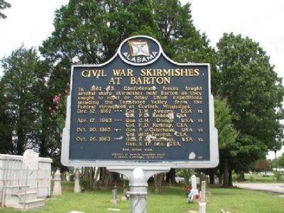
By Sandra Hughes, July 30, 2009
Civil War Skirmish at The Barton Cemetery Marker/side 2
1 ► Alabama, Colbert County, Barton — Civil War Skirmish at The Barton Cemetery / Civil War Skirmishes at Barton —  |
| On Old Lee Highway (County Road 20) at Garner Lane, on the right when traveling west on Old Lee Highway. | |||
| 2 ► Alabama, Colbert County, Cherokee — A Chickasaw Planter — Natchez Trace Parkway — |
| Near Natchez Trace Parkway (at milepost 327.3), 1.4 miles east of N Pike (County Route 21), on the left when traveling east. | |||
| 3 ► Alabama, Colbert County, Cherokee — Barton Hall — |
| Near Cedar Lane (County Road 15) 0.7 miles south of U.S. 72, on the right when traveling east. | |||
| 4 ► Alabama, Colbert County, Cherokee — Bridging Cultures — Natchez Trace Parkway — |
| Near Natchez Trace Access Road (at milepost 327.3), 0.4 miles west of Natchez Trace Parkway, on the right when traveling west. | |||
| 5 ► Alabama, Colbert County, Cherokee — Cherokee High School — |
| On Middle School Road north of Old Lee Highway (County Road 20), on the left when traveling north. | |||
| 6 ► Alabama, Colbert County, Cherokee — Chickasaw Hospitality — Natchez Trace Parkway — |
| Near Natchez Trace Parkway (at milepost 327.3), 1.4 miles east of N Pike (County Route 21), on the left when traveling east. | |||
| 7 ► Alabama, Colbert County, Cherokee — Chickasaw Indian Agency — |
| On Mulberry Lane 0.4 miles east of Moody Lane, on the left when traveling east. | |||
| 8 ► Alabama, Colbert County, Cherokee — Colbert Ferry — |
| Near Natchez Trace Parkway (at milepost 327.3), 1 mile north of N. Pike (County Road 21). | |||
| 9 ► Alabama, Colbert County, Cherokee — Colbert's Stand — |
| On Park Road 0.4 miles north of Natchez Trace Parkway, on the left when traveling east. | |||
| 10 ► Alabama, Colbert County, Cherokee — George Colbert Memorial — |
| Near Natchez Trace Parkway (at milepost 327.3), 1 mile north of N. Pike (County Road 21). | |||
| 11 ► Alabama, Colbert County, Cherokee — History of Cherokee — |
| On Main Street close to 1st Street, on the right when traveling north. | |||
| 12 ► Alabama, Colbert County, Cherokee — Levi Colbert Stand — |
| Near Natchez Trace Access Road (at milepost 320.3), 0.4 miles north of Natchez Trace Parkway (U.S. 72), on the left when traveling north. | |||
| 13 ► Alabama, Colbert County, Cherokee — Mhoontown Cemetery — Colbert County — |
| On Mhoontown Road 1.1 miles east of North Pike, on the right when traveling north. | |||
| 14 ► Alabama, Colbert County, Cherokee — Safe Crossing — Natchez Trace Parkway — National Park Service, U.S. Department of the Interior — |
| Near Natchez Trace Parkway (at milepost 327.3), 1.6 miles east of N Pike (County Route 21), on the left when traveling east. | |||
| 15 ► Alabama, Colbert County, Cherokee — Something to Chew on — Natchez Trace Parkway — National Park Service, U.S. Department of the Interior — |
| On Natchez Trace Access Road (at milepost 320.3), 0.4 miles north of Natchez Trace Parkway. | |||
| 16 ► Alabama, Colbert County, Cherokee — Trace Travelers — Natchez Trace Parkway — |
| Near Natchez Trace Parkway (at milepost 327.3), 1.3 miles east of N Pike (County Route 21), on the left when traveling east. | |||
| 17 ► Alabama, Colbert County, Cherokee — Welcome! — Natchez Trace Parkway — |
| Near Natchez Trace Parkway (at milepost 327.3), 2.7 miles east of N Pike (County Route 21), on the left when traveling east. | |||
| 18 ► Alabama, Colbert County, Cherokee — Wet, Wild, and Wonderful — |
| Near Natchez Trace Parkway (at milepost 327.3), 1.6 miles N Pike (County Route 21), on the left when traveling east. | |||
| 19 ► Alabama, Colbert County, Ford City — The Old Brick Presbyterian Church — 1820 — |
| On Mt. Pleasant Road (County Road 66) 0.3 miles east of County Line Road (County Road 48), on the right when traveling east. | |||
| 20 ► Alabama, Colbert County, LaGrange — LaGrange College — 1830-1855 — |
| On LaGrange College Road south of Alabama Route 157, on the right when traveling north. | |||
| 21 ► Alabama, Colbert County, LaGrange — LaGrange Military Academy — 1857-1862 — |
| Near LaGrange College Road 0.9 miles west of Alabama Route 157. | |||
| 22 ► Alabama, Colbert County, Leighton — Alabama's Historic Byler Road — Alabama's First Road — |
| On Main Street at King Street (Old Alabama Route 20), on the right when traveling north on Main Street. | |||
| 23 ► Alabama, Colbert County, Leighton — Battle of Town Creek — |
| On Old Highway 20 south of King's Lane, on the right when traveling north. | |||
| 24 ► Alabama, Colbert County, Leighton — Frank R. King (1859-1939) — Founder, Tennessee Valley Historical Society — |
| On Main Street at 1st Street, on the left when traveling south on Main Street. | |||
| 25 ► Alabama, Colbert County, Leighton — History of Leighton — |
| On Main Street at King Street, on the right when traveling north on Main Street. | |||
| 26 ► Alabama, Colbert County, Leighton — History of Leighton United Methodist Church — |
| On Main Street 0.1 miles south of 1st Street, on the right when traveling south. | |||
| 27 ► Alabama, Colbert County, Leighton — Jeffers Crossroads / Greggs Stage Stop Tavern — Colbert County — |
| On Old Highway 20 at County Line Rd, on the left when traveling south on Old Highway 20. | |||
| 28 ► Alabama, Colbert County, Leighton — LaGrange College — |
| On Lagrange College Road. | |||
| 29 ► Alabama, Colbert County, Leighton — Leighton Training School — Colbert County — |
| On Jimmy Hughes Street at 1st Street, on the right when traveling west on Jimmy Hughes Street. | |||
| 30 ► Alabama, Colbert County, Leighton — Old Bethel Baptist Church — Older than the State — |
| On County Line Road (Alabama Route 99) 0.2 miles north of Bethel Cemetery Road, on the left when traveling north. | |||
| 31 ► Alabama, Colbert County, Leighton — The Shaw Home — Colbert County — |
| On Shaw Road 0.2 miles 6th Street, on the left when traveling north. | |||
| 32 ► Alabama, Colbert County, Leighton — William Leigh — Founder of Leighton — |
| On Old Hwy 20 east of Morgan Drive, on the right when traveling east. | |||
| 33 ► Alabama, Colbert County, Littleville — History of Littleville, Alabama — |
| On George Wallace Highway (U.S. 43) at Lynwood Avenue (County Route 77), on the right when traveling north on George Wallace Highway. | |||
| 34 ► Alabama, Colbert County, Muscle Shoals — Bainbridge — |
| On Bainbridge Road north of Bainbridge Circle, on the left when traveling north. | |||
| 35 ► Alabama, Colbert County, Muscle Shoals — Birds of North Alabama — |
| Near Reservation Road. | |||
| 36 ► Alabama, Colbert County, Muscle Shoals — Building a New Future — |
| Near Reservation Road 1 mile east of Route 133, on the left when traveling east. | |||
| 37 ► Alabama, Colbert County, Muscle Shoals — Civilian Conservation Corps Park — |
| On CCC Camp Road north of Reservation Rd, on the right when traveling west. | |||
| 38 ► Alabama, Colbert County, Muscle Shoals — Civilian Conservation Corps Pavillion — |
| Near CCC Camp Road north of Reservation Rd. | |||
| 39 ► Alabama, Colbert County, Muscle Shoals — Clyde Carter House — |
| On Lime Kiln Road at Houston Street, on the right when traveling north on Lime Kiln Road. | |||
| 40 ► Alabama, Colbert County, Muscle Shoals — Confederate Retreat at the Tennessee River — |
| On Bainbridge Road (County Road 83) 0.3 miles north of River Road (County Route 40), on the right when traveling north. | |||
| 41 ► Alabama, Colbert County, Muscle Shoals — Explore the River — |
| On Reservation Road. | |||
| 42 ► Alabama, Colbert County, Muscle Shoals — First Southern Baptist Church — |
| On South Wilson Dam Road, on the right when traveling south. | |||
| 43 ► Alabama, Colbert County, Muscle Shoals — Gulls Glorious Gulls — |
| On Reservation Road. | |||
| 44 ► Alabama, Colbert County, Muscle Shoals — History of Muscle Shoals, Alabama — |
| On Avalon Avenue. | |||
| 45 ► Alabama, Colbert County, Muscle Shoals — Home Sweet Home — Heron Rookery — |
| Near Reservation Road. | |||
| 46 ► Alabama, Colbert County, Muscle Shoals — How Does Wilson Dam Work? — |
| On Reservation RD. | |||
| 47 ► Alabama, Colbert County, Muscle Shoals — Howell & Graves School — |
| On S. Wilson Dam Highway 1 mile Kimberley Drive. | |||
| 48 ► Alabama, Colbert County, Muscle Shoals — Muscle Shoals National Recreational Trail — |
| Near Reservation Road. | |||
| 49 ► Alabama, Colbert County, Muscle Shoals — Natural and Cultural Preservation / Protecting Resources — |
| Near Reservation Road 1 mile east of Route 133, on the left when traveling east. | |||
| 50 ► Alabama, Colbert County, Muscle Shoals — Origin of the Francis Turbine — |
| On Wilson Overlook 0.1 miles north of Reservation Road, on the left when traveling north. | |||
| 51 ► Alabama, Colbert County, Muscle Shoals — The Singing River Sculpture — In Muscle Shoals, Alabama — |
| On Avalon Avenue at Brown Street, on the left when traveling west on Avalon Avenue. | |||
| 52 ► Alabama, Colbert County, Muscle Shoals — The TVA System of Multi-Purpose Dams — Wilson Dam — Built for the people of the United States of America — |
| On South Overlook Road east of N Wilson Dam Rd. | |||
| 53 ► Alabama, Colbert County, Muscle Shoals — TVA Goes to War — |
| Near Reservation road 1 mile east of Route 133, on the left when traveling east. | |||
| 54 ► Alabama, Colbert County, Muscle Shoals — TVA: A History of Progress and Innovation / A Valley of Hardships — |
| Near Reservation Road 1 mile east of Route 133, on the left when traveling east. | |||
| 55 ► Alabama, Colbert County, Muscle Shoals — TVA: Our Enduring Mission / Powering Prosperity — |
| Near Reservation Road 1 mile east of Route 133, on the left when traveling east. | |||
| 56 ► Alabama, Colbert County, Muscle Shoals — Wilson Dam — |
| Near Rock Pile Road 0.8 miles north of Reservation Road, on the left when traveling east. | |||
| 57 ► Alabama, Colbert County, Muscle Shoals — Wilson Dam and the TVA System — |
| On Reservation Road. | |||
| 58 ► Alabama, Colbert County, Muscle Shoals — Wilson Dam: Cornerstone of the TVA System — |
| Near Reservation Road 1 mile east of Route 133, on the left when traveling east. | |||
| 59 ► Alabama, Colbert County, Muscle Shoals — Wilson Dam: Setting the Stage — |
| Near Reservation Road 1 mile east of Route 133, on the left when traveling east. | |||
| 60 ► Alabama, Colbert County, Sheffield — 101 Memorial — World War I — |
| Near Hatch Boulevard. | |||
| 61 ► Alabama, Colbert County, Sheffield — E.L. Newman Lustron House — |
| On East 34th Street north of East 14th Avenue, on the right when traveling north. | |||
| 62 ► Alabama, Colbert County, Sheffield — Forest Elders — |
| On Thunder Road. | |||
| 63 ► Alabama, Colbert County, Sheffield — Furnace Hill — |
| On W. 20th Street at W. 15th Street on W. 20th Street. | |||
| 64 ► Alabama, Colbert County, Sheffield — History of Sheffield — |
| On N. Montgomery Avenue near W 3rd St and N. Montgomery Avenue. | |||
| 65 ► Alabama, Colbert County, Sheffield — In Memory of Our Comrades of Sheffield — 1917 - 1919 — |
| On South Montgomery Avenue at East Blake Street, on the right when traveling north on South Montgomery Avenue. | |||
| 66 ► Alabama, Colbert County, Sheffield — Jackson Military Road-Jackson Crossing — |
| On Gordon Drive north of E 13th Street. | |||
| 67 ► Alabama, Colbert County, Sheffield — Nitrate Plant No. 1 — |
| On West 20th Avenue west of Treatment Plant Road, on the right when traveling west. | |||
| 68 ► Alabama, Colbert County, Sheffield — Nitrate Plant No. 1 — |
| On West 20th Avenue west of Treatment Plant Road, on the right when traveling west. | |||
| 69 ► Alabama, Colbert County, Sheffield — Old Railroad Bed — |
| On Ashe Blvd.. | |||
| 70 ► Alabama, Colbert County, Sheffield — Old Railroad Bridge — |
| Near Ashe Boulevard 0.4 miles north of NE 16th Street. | |||
| 71 ► Alabama, Colbert County, Sheffield — Percy Sledge / Producer Quin Ivy — "When A Man Loves A Woman" / NORALA and Quinvy Studios — |
| On East 2nd Street at North Nashville Avenue, on the right when traveling east on East 2nd Street. | |||
| 72 ► Alabama, Colbert County, Sheffield — President Franklin Delano Roosevelt — |
| On South Montgomery Avenue at West 1st Street, on the right when traveling south on South Montgomery Avenue. | |||
| 73 ► Alabama, Colbert County, Sheffield — Sheffield Colored School / Sterling High School — |
| On Sterling Boulevard near Southeast 11th Avenue, on the left when traveling east. | |||
| 74 ► Alabama, Colbert County, Sheffield — The Birth of VFW Post #8640 — |
| On Sterling Boulevard at East 4th Avenue, on the left when traveling south on Sterling Boulevard. | |||
| 75 ► Alabama, Colbert County, Sheffield — The Singing River Sculpture — In Sheffield, Alabama — |
| On North Montgomery Avenue at Alabama Avenue, on the left when traveling north on North Montgomery Avenue. | |||
| 76 ► Alabama, Colbert County, Sheffield — Village One — |
| On Wilson Dam Avenue at Pickwick Street on Wilson Dam Avenue. | |||
| 77 ► Alabama, Colbert County, Tuscumbia — “William Mansel Long, Sr. Memorial Drive” — |
| On South High Street at East 10th Street, on the right when traveling south on South High Street. | |||
| 78 ► Alabama, Colbert County, Tuscumbia — American Indian History — |
| On S. Water Street, on the left when traveling south. | |||
| 79 ► Alabama, Colbert County, Tuscumbia — At This Well — |
| Near Keller Lane at North Commons Street West, on the left when traveling north. | |||
| 80 ► Alabama, Colbert County, Tuscumbia — Belle Mont — |
| On Cook Lane. | |||
| 81 ► Alabama, Colbert County, Tuscumbia — Colbert County Confederate Memorial — |
| On North Main Street at West 4th Street, on the right when traveling south on North Main Street. | |||
| 82 ► Alabama, Colbert County, Tuscumbia — Colbert County Courthouse Square District — |
| On South Main Street at 4th Street, on the right when traveling south on South Main Street. | |||
| 83 ► Alabama, Colbert County, Tuscumbia — Colbert County Gulf War Memorial — |
| On North Main Street at West 3rd Street, on the right when traveling south on North Main Street. | |||
| 84 ► Alabama, Colbert County, Tuscumbia — Colbert County Korean War Memorial — |
| On North Main Street at West 3rd Street, on the right when traveling south on North Main Street. | |||
| 85 ► Alabama, Colbert County, Tuscumbia — Colbert County Persian Gulf War Memorial — |
| On North Main Street at West 3rd Street, on the right when traveling south on North Main Street. | |||
| 86 ► Alabama, Colbert County, Tuscumbia — Colbert County Vietnam War Memorial — |
| On North Main Street at West 3rd Street, on the right when traveling south on North Main Street. | |||
| 87 ► Alabama, Colbert County, Tuscumbia — Colbert County World War I Memorial — April 6, 1917 — November 11, 1918 — |
| On North Main Street at West 3rd Street, on the right when traveling south on North Main Street. | |||
| 88 ► Alabama, Colbert County, Tuscumbia — Colbert County World War II Memorial — |
| On North Main Street at West 3rd Street, on the right when traveling south on North Main Street. | |||
| 89 ► Alabama, Colbert County, Tuscumbia — Cold Water Falls — |
| On S. Main Street. | |||
| 90 ► Alabama, Colbert County, Tuscumbia — Engagement at Little Bear Creek — October 26-27, 1863 |
| On Old Lee Highway at East Lee Highway (U.S. 72), on the right when traveling west on Old Lee Highway. Reported missing. | |||
| 91 ► Alabama, Colbert County, Tuscumbia — Ethel Davis Plaza — In Memory of — Ethel Davis, Artist — |
| On North Water Street, on the right when traveling south. | |||
| 92 ► Alabama, Colbert County, Tuscumbia — First Baptist Church — |
| On N. Dickson St.. | |||
| 93 ► Alabama, Colbert County, Tuscumbia — First Presbyterian Church — |
| On East 4th Street at North Broad Street, on the right when traveling east on East 4th Street. | |||
| 94 ► Alabama, Colbert County, Tuscumbia — Gov. Robert Burns Lindsay / Maud McKnight Lindsay — July 4, 1824 - February 13, 1902 / May 13, 1874 - May 30, 1941 — |
| On North Main Street at East 1st Street, on the right when traveling north on North Main Street. | |||
| 95 ► Alabama, Colbert County, Tuscumbia — Henry Emmett (Heinie) Manush — July 20, 1901 - May 12, 1971 — |
| On East 3rd Street east of N East Street, on the right when traveling west. | |||
| 96 ► Alabama, Colbert County, Tuscumbia — History of Tuscumbia, Alabama — |
| On South Main Street at West 6th Street, on the right when traveling south on South Main Street. | |||
| 97 ► Alabama, Colbert County, Tuscumbia — Howell Thomas Heflin — 1921~2005 — |
| On S. Main Street close to 4th Street, on the right when traveling south. | |||
| 98 ► Alabama, Colbert County, Tuscumbia — In Memoriam Helen Keller and Adylise Sherrod Grimsley — |
| Near Keller Lane north of North Commons Street West, on the left when traveling north. | |||
| 99 ► Alabama, Colbert County, Tuscumbia — Ivy Green — Birthplace of Helen Keller — |
| On N. Commons St West. | |||
| 100 ► Alabama, Colbert County, Tuscumbia — Jackson's Military Road — |
| On South Dickson Street at East 7th Street, on the right when traveling south on South Dickson Street. | |||
395 entries matched your criteria. The first 100 are listed above. Next 100 ⊳