By Mark Parker, July 20, 2023
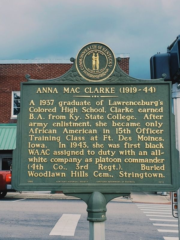
Anna Mac Clarke (1919-44) Marker
| On South Main Street (Business Kentucky Route 127) at East Court Street, on the right when traveling north on South Main Street. |
| On North Main Street at Posey Street, on the right when traveling north on North Main Street. |
| On Fox Creek Road (U.S. 62) 0.2 miles south of Mill Creek Pike ( Route 513), on the right when traveling north. |
| On East Woodford Street (U.S. 62) near Dogwood Drive, on the left when traveling east. |
| On U.S. 127, on the left when traveling north. |
| On East Woodford Street (U.S. 62) east of Dogwood Drive, on the right when traveling west. |
| On U.S. 127 0.4 miles south of Gilberts Creek Road ( Route 513), on the left when traveling north. |
| On Harrodsburg Road (Business U.S. 127) at Salt River Road, on the right when traveling south on Harrodsburg Road. |
| On West Broadway Street (U.S. 62) at Old Frankfort Road (U.S. 127), on the right when traveling west on West Broadway Street. |
| On See Road, on the right when traveling east. |
| On Cane Ridge Road (Kentucky Route 537) at See Road, on the left when traveling south on Cane Ridge Road. |
| On Russell Cave Road (Kentucky Route 353) 0.1 miles south of Centerville Lane, on the left when traveling south. |
| On Main Street north of East 5th Street, on the right when traveling north. |
| On Main Street 0.1 miles north of East 11th Street, on the right when traveling north. |
| On Main Street (Business U.S. 68) at 9th Street, on the right when traveling north on Main Street. |
| Near Paris Cemetery 5th Road east of Paris Cemetery 6th Road. |
| Near Main Street at Ardery Place, on the left when traveling north. |
| On Main Street at Ardery Place, on the left when traveling east on Main Street. |
| On Ardery Place at High Street (U.S. 460), on the right when traveling east on Ardery Place. |
| On Main Street (U.S. 460), on the left when traveling north. |
| On U.S. 27 at Highway 1876, on the right when traveling south on U.S. 27. |
| On Cane Ridge Road (Kentucky Route 537) at Steele Road on Cane Ridge Road. |
| On Colville Road (Kentucky Route 3118) north of Endicott Lane, on the right when traveling north. |
| On Bank Row Street (U.S. 460) at High Street (U.S. 460), on the left when traveling west on Bank Row Street. |
| On High Street at Ardery Place, on the right when traveling south on High Street. |
| On High Street (U.S. 460), on the right when traveling south. |
| On High Street (U.S. 460), on the right when traveling south. |
| On Winchester Street (Kentucky Route 627) at Vine Street, on the right when traveling south on Winchester Street. |
| On High Street at 9th Street, on the right when traveling south on High Street. |
| On Russell Cave Road (Kentucky Route 353) 0.3 miles south of Centerville Lane, on the right when traveling south. |
| On Winchester Street (Kentucky Route 627) at Link Avenue, on the right when traveling south on Winchester Street. |
| On U.S. 27 at Hutchison Station Road ( Route 1939), on the right when traveling north on U.S. 27. |
| On Main Street (U.S. 460), on the left when traveling north. |
| On Georgetown Road (U.S. 460) east of Clay Kiser Road, on the right when traveling east. |
| On Winchester Road (Kentucky Route 627) 0.2 miles Stoney Point Road, on the left when traveling north. |
| On Paris Cemetery 3rd Road west of Main Street (Business U.S. 68), on the left when traveling west. |
| On Winchester Street (Kentucky Route 627) at East 10th Street, on the left when traveling south on Winchester Street. |
| On Ruddells Mill Road (Kentucky Route 1940) at Old Ruddles Mill Road ( Route 1893), on the right when traveling south on Ruddells Mill Road. |
| On Russell Cave Road (State Road 353) at Silas Road on Russell Cave Road. |
| Near Millersburg Road (U.S. 68) 1.4 miles east of Jackstown Road, on the right when traveling east. |
| Near Millersburg Road (U.S. 68) 1.4 miles east of Jackstown Road, on the right when traveling east. |
| On Russell Cave Road (Kentucky Route 353) 0.3 miles south of Hawkins-Cummins Road, on the right when traveling south. |
| On High Street (U.S. 460) south of Ardery Place, on the left when traveling south. |
| On College Street, on the left when traveling north. |
| On 2nd Street, on the right when traveling north. |
| On South Second Street at East Walnut Street, on the left when traveling south on South Second Street. |
| On West Main Street, on the right when traveling west. |
| On West Main Street, on the right when traveling west. |
| Near West Main Street (U.S. 127) east of College Street, on the left when traveling west. Reported permanently removed. |
| On U.S. 150 at Airport Road ( Route 1273), on the right when traveling south on U.S. 150. |
| On West Main Street, on the left when traveling west. |
| On East Lexington Avenue west of Proctor Street, on the left when traveling east. |
| On Stanford Avenue (Kentucky Route 150) at Letton Drive, on the right when traveling north on Stanford Avenue. |
| On West Main Street at North 4th Street, on the right when traveling west on West Main Street. |
| On E Walnut street on E Walnut street. |
| On West Main Street (Business U.S. 150) at North 4th Street, on the right when traveling west on West Main Street. |
| On 2nd. street south of Main Street ( Route 34, 52), on the right when traveling south. |
| On West Main Street east of College Street, on the right when traveling east. |
| On South 2nd Street south of Main Street ( Route 34, 52), on the right when traveling south. |
| On South 3rd Street at Jacob Street, on the left when traveling north on South 3rd Street. |
| On West Main Street at North 4th Street, on the right when traveling west on West Main Street. |
| On 2nd. Street south of Main Street, on the left when traveling south. |
| On Lexington Street (Kentucky Route 34) at Cecilian Terrace, on the right when traveling west on Lexington Street. |
| On Harrodsburg Road (U.S. 127) at Gentry Lane (County Road 1915), on the right when traveling north on Harrodsburg Road. |
| On Walnut Street (U.S. 150), on the left when traveling east. |
| Near East Walnut Street at North 1st Street, on the right when traveling west. |
| On Shakertown Road (Kentucky Route 33) north of Faulkner Lane ( Route 1896), on the left when traveling north. |
| On South Second Street, on the left when traveling north. |
| On Main Street (Kentucky Route 34, 52) east of Second Street, on the left when traveling west. |
| On West Main Street (U.S. 150), on the left when traveling east. |
| On Stanford Ave (Kentucky Route 150), on the left when traveling north. |
| On East Lexington Avenue at Proctor Street, on the left when traveling east on East Lexington Avenue. |
| On Main Street, on the right when traveling east. |
| On North Danville Bypass (Bypass Route 127) 0.2 miles north of Lannock Drive, on the right when traveling north. |
| On West Walnut Street at College Street, on the right when traveling east on West Walnut Street. |
| Near West Walnut Street 0.1 miles west of College Street, on the right when traveling west. |
| On Stanford Avenue (Kentucky Route 150), on the right when traveling north. |
| On Perryville Road (U.S. 150) at Quirks Run Road ( Route 1822), on the right when traveling east on Perryville Road. |
| On West Main Street at North 4th Street, on the right when traveling west on West Main Street. |
| On West Main Street (U.S. 150), on the left when traveling west. |
| On North 3rd Street (Kentucky Route 33) south of West Lexington Avenue, on the right when traveling south. |
| On West Main Street at South Fourth Street, on the right when traveling east on West Main Street. |
| On West Main Street, on the right when traveling east. |
| On East Walnut Street, on the left when traveling east. |
| On West Main Street, on the right when traveling east. |
| On Main Street at South 2nd Street, on the right when traveling east on Main Street. |
| On East Walnut Street, on the right when traveling east. |
| On Isaac Shelby Road, on the right when traveling south. |
1030 entries matched your criteria. The first 100 are listed above.
Next 100 ⊳
