By Mark Hilton, March 19, 2024
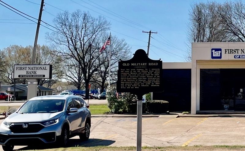
Old Military Road Marker
| On Old Military Road West (Arkansas Route 306) at South Main Street ( Route 1), on the left when traveling west on Old Military Road West. |
| On Old Military Road West (Arkansas Route 306) at South Main Street ( Route 1), on the left when traveling west on Old Military Road West. |
| On North Forrest Street at East Garland Avenue, on the left when traveling north on North Forrest Street. |
| On South Washington Street (State Highway 18) at Front Street, on the left when traveling south on South Washington Street. |
| On New Castle Road (Arkansas Route 284) 0.4 miles south of Kittle Road, on the right when traveling south. |
| On South Izard Street south of Court Avenue, on the left when traveling south. |
| On Front Street east of South Izard Street, on the left when traveling east. |
| On South Izard Street just south of Court Avenue, on the left when traveling south. |
| On U.S. 70 0.3 miles east of County Road 769, on the right when traveling east. |
| On South Main Street south of Ripley Avenue (State Highway 370), on the left when traveling south. |
| On South Main Street south of Ripley Avenue (State Highway 370), on the left when traveling south. |
| On South Main Street at Ripley Avenue (State Highway 370), on the right when traveling north on South Main Street. |
| On Ripley Avenue (Mississippi Route 370) east of South Main Street, on the right when traveling east. |
| On Main Street (State Highway 702) east of State Highway 7, on the left when traveling east. |
| On Mississippi Route 7 0.2 miles north of Main Street, on the left when traveling east. |
| On Bobo-New Africa Road west of West Bobo Road, on the right when traveling west. |
| On Martin Luther King Boulevard at Ashton Alley, on the right when traveling west on Martin Luther King Boulevard. |
| On Sunflower Avenue at Martin Luther King Boulevard, on the left when traveling north on Sunflower Avenue. |
| On Delta Avenue at 1st Street, on the right when traveling north on Delta Avenue. |
| On Desoto Avenue (U.S. 49E) at North State Street (U.S. 61), on the right when traveling north on Desoto Avenue. |
| On Sunflower Avenue at 1st Street, on the right when traveling south on Sunflower Avenue. |
| Near Blues Alley at Delta Avenue. |
| On Martin Luther King Boulevard at Ashton Alley, on the right when traveling west on Martin Luther King Boulevard. |
| On Martin Luther King Boulevard 0.1 miles west of Yahoo Avenue, on the right when traveling west. |
| On West 2nd Street at Riverside Avenue, on the right when traveling east on West 2nd Street. |
| On Yazoo Avenue at Martin Luther King Boulevard, on the right when traveling north on Yazoo Avenue. |
| On Delta Avenue north of Sunflower Avenue, on the right when traveling north. |
| On 3rd Street at Yahoo Avenue, on the left when traveling east on 3rd Street. |
| Near Clark Street at Yahoo Avenue. |
| On Delta Avenue north of East 2nd Street, on the right when traveling north. |
| On Sunflower Avenue 0.2 miles south of Martin Luther King Boulevard, on the right when traveling south. |
| On Issaquena Avenue 0.1 miles north of Martin Luther King Boulevard, on the right when traveling south. |
| Near Blues Alley at Yahoo Avenue. |
| On Delta Avenue 0.1 miles north of 1st Street, on the right when traveling south. |
| On Clark Street at Yazoo Avenue, on the left when traveling east on Clark Street. |
| On Desoto Avenue at North State Street, on the right when traveling north on Desoto Avenue. |
| On Martin Luther King Boulevard at Harrison Avenue, on the right when traveling east on Martin Luther King Boulevard. |
| On Issaquena Avenue at Blues Alley, on the right when traveling south on Issaquena Avenue. |
| On Issaquena Avenue at Blues Alley, on the right when traveling south on Issaquena Avenue. |
| On Delta Avenue 0.1 miles south of East 2nd Street, on the right when traveling south. |
| On Blues Highway (U.S. 49/61) at Farrell-Eagles Nest East, on the right when traveling north on Blues Highway. |
| On Coahoma-Rich Road 0.9 miles south of U.S. 61, on the right when traveling south. |
| On U.S. 61 0.3 miles south of Old Pumping Station Road, on the right when traveling north. |
| On U.S. 49 at State Route 1, on the right when traveling south on U.S. 49. |
| On Moon Lake Road north of Moon Road, on the right when traveling north. |
| On 2nd Street at Church Street, on the left when traveling north on 2nd Street. |
| On 2nd Street at Washington Street, on the left when traveling north on 2nd Street. |
| On 2nd Street at Webb Street, on the left when traveling north on 2nd Street. |
| On 2nd Street at Church Street, on the left when traveling north on 2nd Street. |
| On Rozell Street east of Sheriff Ridge Avenue, on the right when traveling east. |
| On 2nd Street north of Webb Street, on the right when traveling north. |
| On Commissary Circle at Hopson Road, on the left when traveling north on Commissary Circle. |
| On State Highway 322 at U.S. 49, on the right when traveling west on State Highway 322. |
| On South Front Avenue at 2nd Street, on the left when traveling north on South Front Avenue. |
| On State Highway 6 0.5 miles east of Crum Road, on the right when traveling east. |
| On Park Street south of Hopson Street, on the right when traveling south. |
| On Oakhurst Stovall Road at Farrell-Eagles Nest West, on the right when traveling south on Oakhurst Stovall Road. |
| On Lee Creek Road east of Cayce Road, on the right when traveling east. |
| On Salem Avenue (State Highway 4) east of West Street, on the right when traveling east. |
| On Salem Avenue just east of West Street, on the right when traveling east. |
| On West College Avenue 0.1 miles west of South Craft Street, on the left when traveling west. |
| On Rust Avenue east of North Memphis Street (State Route 7), on the right when traveling east. |
| On South Memphis Street at East Van Dorn Avenue, on the left when traveling south on South Memphis Street. |
| On East Van Dorn Avenue (Mississippi Route 4/178) at South Market Street, on the right when traveling west on East Van Dorn Avenue. |
| On East College Avenue at North Center Street, on the right when traveling west on East College Avenue. |
| On Memphis Street at Van Dorn Avenue, on the right when traveling north on Memphis Street. |
| On South Memphis Street at West Gholson Avenue, on the left when traveling south on South Memphis Street. |
| On Rust Avenue east of North Memphis Street (State Route 178), on the right when traveling east. |
| On East College Street at South Market Street, on the right when traveling west on East College Street. |
| On North Center Street at East Falconer Avenue, on the right when traveling north on North Center Street. |
| On Marianna Road 0.4 miles east of Pegues Road, on the right when traveling east. |
| On East Van Dorn Avenue (Mississippi Route 178) at South Center Street, on the right when traveling east on East Van Dorn Avenue. |
| On East Salem Avenue (Mississippi Route 4) at Bonner Street, on the left when traveling east on East Salem Avenue. |
| On East Van Dorn Avenue east of South Compress Street, on the left when traveling east. |
| On South Memphis Street at East College Avenue, on the left when traveling south on South Memphis Street. |
| On North Center Street at East Falconer Avenue, on the right when traveling north on North Center Street. |
| On West Valley Avenue west of Jeanette Street, on the left when traveling west. |
| On North Memphis Street (Mississippi Route 7) 0.2 miles north of Rust Avenue, on the right when traveling north. |
| On Rust Avenue east of North Memphis Street (State Route 7), on the right when traveling east. |
| On Salem Avenue east of Bonner Street, on the left when traveling east. |
| On South Memphis Street at East Van Dorn Avenue, on the left when traveling south on South Memphis Street. |
| On East Van Dorn Avenue (Mississippi Route 4/178) at South Market Street, on the right when traveling east on East Van Dorn Avenue. |
| On Salem Avenue (Mississippi Route 4) east of North Bethlehem Street, on the left when traveling east. Reported missing. |
| On West Valley Avenue west of Jeanette Street, on the right when traveling west. |
| On West Chulahoma Avenue 0.2 miles west of South Craft Street (State Route 7), on the right when traveling west. |
| On East College Avenue at North Walthall Street, on the left when traveling east on East College Avenue. |
| On East Gholson Avenue at South Memphis Street, on the right when traveling west on East Gholson Avenue. |
| On Mississippi Route 7 1.5 miles south of Waterford Mountain Road, on the right when traveling south. Reported missing. |
| On U.S. 51 just north of North Street, on the right when traveling north. |
| On Central Avenue west of 2nd Street, on the right when traveling west. |
| On West Main Street just west of Center Street, on the right when traveling west. |
| Near Brownsferry Road at Highway 51. |
| On U.S. 51 0.3 miles north of State Route 740, on the right when traveling north. |
| Near Front Street south of Tate Street. |
| On North Front Street at West Main Street, on the right when traveling north on North Front Street. |
| On Center Street south of West Tate Street, on the right when traveling north. |
| On South Ward Street at Court Street, on the left when traveling north on South Ward Street. |
| On Brownsferry Road at U.S. 51, on the right when traveling east on Brownsferry Road. |
| On State Highway 59 0.1 miles east of Welch Road, on the right when traveling east. |
| On State Highway 18/57 at State Highway 57, on the right when traveling north on State Highway 18/57. |
692 entries matched your criteria. The first 100 are listed above.
Next 100 ⊳
