By Barry Swackhamer, May 7, 2018
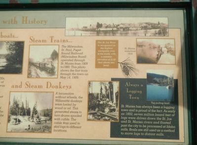
St. Maries - Steaming with History Marker, right half
| On Main Avenue near North Sixth Street (State Highway 5), on the right when traveling east. |
| Near Moon Pass Road (Federal Road 456) 0.4 miles south of Loop Creek Road (Federal Road 326). |
| Near Cliff Creek Road (Federal Road 506) 3.7 miles north of Loop Creek Road (Federal Road 326). |
| Near Cliff Creek Road (Federal Road 506) 1.8 miles north of Loop Creek Road (Federal Road 326). |
| Near Moon Pass Road (Federal Road 456) 0.4 miles south of Loop Creek Road (Federal Road 326). |
| Near Moon Pass Road (Federal Road 456) 0.4 miles south of Loop Creek Road (Federal Road 326). |
| Near Loop Creek Road (Federal Road 326) 4 miles west of Cliff Creek Road (Federal Road 506). |
| Near Moon Pass Road (Federal Road 456) 0.4 miles south of Loop Creek Road (Federal Road 326). |
| Near Loop Creek Road (Federal Road 326) 4 miles west of Cliff Creek Road (Federal Road 506). |
| Near Cliff Creek Road (Federal Road 506) 2.6 miles north of Loop Creek Road (Federal Road 326). |
| Near Loop Creek Road (Federal Road 326) 4 miles west of Cliff Creek Road (Route 506). |
| Near Cliff Creek Road (Federal Road 506) 1.8 miles north of Loop Creek Road (Federal Road 326). |
| Near Loop Creek Road (Federal Road 326) 4 miles west of Cliff Creek Road (Federal Road 506). |
| Near Moon Pass Road (Federal Road 456) 0.4 miles south of Loop Creek Road (Federal Road 326). |
| Near Cliff Creek Road (Federal Road 506) 4 miles north of Loop Creek Road (Federal Road 326). |
| Near Moon Pass Road (Federal Road 456) 0.4 miles south of Loop Creek Road (Federal Road 326). |
| Near Cliff Creek Road (Federal Road 506) 1.8 miles north of Loop Creek Road (Federal Road 326). |
| Near Loop Creek Road (Federal Road 326) 4 miles west of Cliff Creek Road (Federal Road 506). |
| Near Cliff Creek Road (Federal Road 506) 1.8 miles north of Loop Creek Road (Federal Road 326). |
| Near Moon Pass Road (Federal Road 456) 0.4 miles south of Loop Creek Road (Federal Road 326). |
| Near Loop Creek Road (Federal Road 326) 4 miles west of Cliff Creek Road (Federal Road 506). |
| Near Cliff Creek Road (Federal Road 506) 3.7 miles north of Loop Creek Road (Route 326). |
| Near Moon Pass Road (Federal Road 456) 0.4 miles south of Loop Creek Road (Federal Road 326). |
| Near Cliff Creek Road (Federal Road 506) 1.8 miles north of Loop Creek Road (Federal Road 326). |
| Near Cliff Creek Road (Federal Road 506) 2.6 miles north of Loop Creek Road (Federal Road 326). |
| Near Moon Pass Road (Federal Road 456) 0.4 miles south of Loop Creek Road (Federal Road 326). |
| On North Prescott Avenue at North Livermore Avenue, on the right when traveling west on North Prescott Avenue. |
| On North Avenue (Illinois Route 64) 0.1 miles west of Kingsbury Street, on the right when traveling east. |
| Near West Jackson Boulevard just east of South Clinton, on the left when traveling east. |
| On Franklin Avenue north of Atlantic Street, on the right when traveling west. |
| On Irving Park Road (Illinois Route 19) near Catalpa Avenue, on the right when traveling east. |
| On Catalpa Avenue south of Irving Park Road ( Route 19), on the right when traveling north. |
| On Catalpa Avenue close to Irving Park Road ( Route 19), on the right when traveling north. |
| Near North 10th Street north of Hickman Road (U.S. 6), on the right when traveling north. |
| On East Lincolnway Street east of South Cedar Street, on the right when traveling east. |
| On East Main Street (State Highway 44) just east of Southeast 6th Street, on the right when traveling east. |
| On 2nd Avenue SW at South Elm Street on 2nd Avenue SW. |
| Near 10th Street just north of 6th Avenue, on the right when traveling north. |
| Near S. 2nd Street west of 5th Avenue S., on the right when traveling west. |
| On Washington Avenue S. east of 4th Avenue S., on the right when traveling east. |
| On Minnehaha Avenue south of East Minnehaha Parkway, on the right when traveling south. |
| On the Midtown Greenway east of 10th Avenue S., on the right when traveling east. |
| On East Front Street at South St. Paul Avenue on East Front Street. |
| On Phalen Boulevard west of Cayuga Street, on the right when traveling west. |
| Near West 22nd Street west of Baltimore Avenue. |
| Near West 22nd Street west of Baltimore Avenue. |
| On Locust Street south of Calhoun Street, on the right when traveling south. |
| On Locust Street at Calhoun Street, on the left when traveling north on Locust Street. |
| Near Barrett Station Road east of Old Dougherty Ferry Road, on the right when traveling east. |
| Near Barrett Station Road east of Old Dougherty Ferry Road, on the right when traveling east. |
| Near Barrett Station Road east of Old Dougherty Ferry Road, on the right when traveling east. |
| On River Drive North at !st Avenue North on River Drive North. |
| On Jail House Lane near North 1, on the right when traveling south. |
| On Main Street (State Highway 59) near South Jordan Avenue, on the right when traveling east. |
| On North Cottage Grove Avenue near Main Street, on the left when traveling north. |
| On Main Street (State Highway 59) at South Strevell Avenue, on the right when traveling east on Main Street. |
| On Earl Street near 6th Avenue South, on the right when traveling east. |
| On U.S. 87 near H Street, on the left when traveling west. |
| On North Church Avenue at East Davis Street when traveling north on North Church Avenue. |
| Near Story Mill Road at Hillside Lane, on the left when traveling south. |
| On East Cedar Street near 2nd Avenue East, on the right when traveling west. |
| On Main Street near First Avenue West, on the left when traveling north. |
| On Main Street at Railway Avenue West, on the left when traveling north on Main Street. |
| On State Highway 287 0.1 miles south of California Street, on the right when traveling south. |
| On Interstate 90 at milepost 73, on the right when traveling west. |
| Near Rainy Creek Road (Federal Road 506) 2 miles south of Exit 5 (Taft) (Interstate 90). |
| Near Rainy Creek Road (Federal Road 506) 2 miles south of Exit 5 (Taft) (Interstate 90). |
| Near Rainy Creek Road (Federal Route 506) 2 miles south of Exit 5 (Taft) (Montana Highway 90). |
| Near Rainy Creek Road (Federal Road 506) near Exit 5 (Taft) (Interstate 90). |
| On Interstate 90 at milepost 4, on the right when traveling east. |
| On State Highway 200 at milepost 32 near State Road 83, on the left when traveling west. |
| On Woody Street north of West Broadway Street, on the left when traveling north. |
| On North Higgins Avenue near West Alder Street, on the left when traveling north. |
| On Main Street (Business Interstate 90) at Conley Avenue, on the right when traveling south on Main Street. |
| On Main Street (Business Interstate 90) at Conley Avenue, on the right when traveling south on Main Street. |
| On West Old Highgway 19 at Milwaukee Road, on the right when traveling south on West Old Highgway 19. |
| On North 13th Avenue near Park Street when traveling north. |
| On U.S. 12 near 'Main Street', on the left when traveling west. |
| On First Avenue near Third Street, on the left when traveling west. |
| On Main Street at First Avenue (?), on the left when traveling north on Main Street. |
| On Highway 2 9.8 miles south of U.S. 90, on the left when traveling east. |
| On South Montana Street (Business Interstate 15/90) just south of West 2nd Street, on the left when traveling north. |
| On Central Avenue North at Second Street Northwest (U.S. 12), on the left when traveling west on Central Avenue North. |
| On Southwest Street, on the right when traveling north. |
| On Southwest Street, on the right when traveling north. |
| On 1st Street East (U.S. 212) east of East 1st Avenue, on the right when traveling east. |
| On East 4th Street at South Charles Avenue, on the right when traveling west on East 4th Street. |
| On South Jackson Street near 4th Avenue South, on the right when traveling west. |
| On 1st Street at Avenue D, on the left when traveling west on 1st Street. |
| Near North Howard Street at West Spokane Falls Boulevard when traveling north. |
| Near North Spokane Falls Court 0.1 miles north of West Spokane Falls Boulevard. |
| On South Washington Street at Crooks Street, on the right when traveling south on South Washington Street. |
| Near South Washington Street at Crooks Street. |
| On Market Street at DeForest Street, on the left when traveling south on Market Street. |
| On West Washington Avenue 0.1 miles west of South Bedford Street, on the right when traveling west. |
| On Brodhead Street (County Road Y) at American Legion Street, on the right when traveling south on Brodhead Street. |
106 entries matched your criteria. The first 100 are listed above.
The final 6 ⊳
