During the 19th Century, a series of lighthouses at this location aided mariners entering New Inlet. The first lighthouse was completed in 1817, but was destroyed by fire in 1836. Construction on a replacement began the following year, and the . . . — — Map (db m278929) HM
Determined to close the port of Wilmington, a combined effort by Union army and naval forces gathered to capture Fort Fisher in December 1864. 64 warships, mounting 619 guns, fired 20,000 shells, making the naval bombardment the largest of the . . . — — Map (db m278943) HM
Taken in June 1861 when the Navy Yard at
Norfolk was abandoned by the United States
Banded and converted
at Richmond into a 6 Inch Rifle
Mounted at Fort Caswell North Carolina
Dismounted by exploding magazines
when the Confederates . . . — — Map (db m278954) HM
Taken in June 1861 when the Navy Yard at
Norfolk was abandoned by the United States
Banded and converted
at Richmond into a 6 Inch Rifle
Mounted at Fort Caswell North Carolina
Dismounted by exploding magazines
when the Confederates . . . — — Map (db m278955) HM
Garrison life at Fort Fisher was mundane. "Work, work - all the time and no rest except Sabbaths," complained one soldier stationed at the fort. Contending with mosquitoes in the summer and the howling winds across the point in the winter, the . . . — — Map (db m278946) HM
After the fall of Fort Fisher, the Armstrong gun became a war trophy and the focus of photographs and newspaper articles. Union soldiers, such as Captain Trickey of the 3rd New Hampshire, noted the “elegantly mounted Armstrong gun...the carriage . . . — — Map (db m278796) HM
Fort Fisher was an engineering marvel during the American Civil War. Unlike masonry fortifications, such as Forts Macon and Sumter that preceded it, Fort Fisher was an earthen fortification, the largest ever built by the Confederacy. It spanned more . . . — — Map (db m278923) HM
The wounding of Col. William Lamb eventually left command of Fort Fisher to Maj. James Reilly, who faced an impossible task of attempting another counterattack. It was quickly repulsed and, less than an hour later, a fourth brigade entered the sally . . . — — Map (db m278926) HM
These are the remnants of Battery Buchanan, named for Confederate Adm. Franklin Buchanan. It was constructed in 1864 to guard this point and also to serve as “a citadel to which an overpowered garrison might retreat.” It was the last . . . — — Map (db m28637) HM
Steam-powered blockade-runners, usually British, made 1,300 attempts to enter Southern ports with vital supplies during the Civil War. More than 1,000 of the trips succeeded.
The most successful vessels were specially built for the . . . — — Map (db m278763) HM
The agricultural South imported many things from Europe, particularly Great Britain. The North blockaded southern ports to stop this trade. In response, the Confederates used fast ships for blockade-running.
(captions)
Cotton . . . — — Map (db m278760) HM
Ethyl-Dow plant, which operated here, 1934-1945, pioneered extraction of bromine from sea water. Element used in Ethyl, anti-knock gas compound. — — Map (db m125712) HM
The Union fleet returned in January 1865 and fired another 20,000 shells in three days. Supported by this massive gunfire and a naval landing party, the U.S. Army captured the fort on January 15.
(captions)
As 2,000 U.S. sailors . . . — — Map (db m278932) HM
In front of you is the fourth traverse. On January 15, 1865, this was the scene of the hottest fighting within the fort. Union flags seen floating above Shepherd's Battery, to your left, prompted Gen. W.H.C. whiting to call for a counterattack. He . . . — — Map (db m278919) HM
Seacoast erosion, intensified by hurricanes and other major storms, has been a problem and controversial issue at Fort Fisher and elsewhere along the North Carolina coast for decades.
Erosion at Fort Fisher intensified after the 1930s. By 1968 . . . — — Map (db m278762) HM
Largest earthen coastal fortification in the Confederacy. Original construction commenced May, 1861 and continued until December, 1864, when the fort came under Federal assault. Fort Fisher kept Wilmington open to blockade runners, providing a . . . — — Map (db m28634) HM
After the 1860 presidential election, eleven southern states voted to leave or "secede" from the United States. Many White southerners believed the new administration threatened slavery - the cornerstone of their society.
The seceded states . . . — — Map (db m278951) HM
(south face)
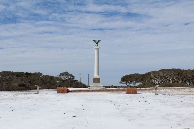
In memory of those men of the Confederate States Army who for more than three years manned the guns of Fort Fisher under command of Colonel William Lamb, Major General W.H.C. Whiting and Major James Reilly.
(north . . . — — Map (db m28640) HM
The most effective gun in the fort. – Col. William Lamb, Fort Fisher commander
The Confederacy relied heavily on English artillery during the Civil War. A variety of English cannons, including Whitworths and Blakelys, were imported and . . . — — Map (db m278797) HM
In April 1861 Capt. Charles P. Bolles began building individual gun batteries at Confederate Point.
(captions)
The fort was named for Col. Charles F. Fisher, killed at the First Battle of Manassas
In May 1861 Capt. William . . . — — Map (db m278795) HM
Here stood the Headquarters of Fort Fisher. The construction of the fort began in the summer of 1862 under the direction of Colonel William Lamb Commandant, who with General W.H.C. Whiting and Major James Reilly served until the fort was . . . — — Map (db m28635) HM
In the Civil War Fort Fisher kept the port of Wilmington open for crucial supplies from Europe. The fort finally fell in January 1865 after two of the largest sea-land battles of the war.
(captions)
List of guns in Fort . . . — — Map (db m278794) HM
According to the Federal battle plan, 1,600 sailors and 400 marines were to attack the sea face of Fort Fisher, while 3,700 troops were to assault the land face. Admiral Porter described his plan as follows: "[T]he sailors will be armed with . . . — — Map (db m278945) HM
The signal was given and the line[,] despite the storm of bullets and cannister which strewed the interval with dead and wounded, [we] rushed forward like a tempest, through the stockade and up the parapet. Dr. James Mowris, . . . — — Map (db m278856) HM
Col. William Lamb took command on July 4, 1862. For two years over 1,000 soldiers, slaves, and free blacks worked six days a week.
(captions)
The landface in 1865 showed the results of Lamb’s work.
Lamb built elevated . . . — — Map (db m278947) HM
Blockade runner. Ran aground and sank 400 yds. E., June 1862. Its salvage 1962 led state to open an underwater archaeology office. — — Map (db m125748) HM
Lt. Col. George Deas, Confederate Staff officer who inspected the Cape Fear District defenses in 1864
Wilmington, North Carolina was the second most fortified city in the South, behind Charleston. The city served as the hub of a . . . — — Map (db m278909) HM
The city of Wilmington was captured on February 22, 1865. Union troops continued to occupy Fort Fisher and Federal Point under the Union military occupation policy known as General Order Number 8, issued on February 27, 1865.
Postwar occupation . . . — — Map (db m278936) HM
Over the years man and nature destroyed much of Fort Fisher. Restoration of this battery was based on archaeological, historical, and photographic evidence.
(captions)
Workers inspect a new tunnel entrance.
Volunteers in . . . — — Map (db m278863) HM
The River Road sally port was the fort’s main land entrance.
At 3:30 p.m. on January 15, 1865, Union infantry charged into this end of the fort. — — Map (db m278949) HM
The Cape Fear River served as the lifeline for blockade runners brining in supplies for the Confederacy. It also served as the pathway to freedom for enslaved African Americans, who wanted to leave Wilmington.
Freedom seekers, also known as . . . — — Map (db m278903) HM
Shepherd’s, one of the oldest batteries in the fort, guarded its western end.
(captions)
A 10-inch Columbiad like this damaged one was at Shepherd’s. This old smoothbore fired a 130-pound round ball 3 miles.
This is how . . . — — Map (db m278862) HM
Shepherd’s, one of the oldest batteries in the fort, guarded its western end.
(captions)
A 10-inch Columbiad like this damaged one was at Shepherd’s. This old smoothbore fired a 130-pound round ball 3 miles.
This is how . . . — — Map (db m278864) HM
Improved artillery made brick forts obsolete. Rooms covered with sand provided better protection for defenders.
(captions)
Here at Shepherd’s Battery the entrance tunnel was 63 feet long and 3 feet wide. The bombproof itself . . . — — Map (db m278861) HM
Home of rifled and banded 32-pounder gun
Loud Paul
Named in appreciation and memory of
Paul M. Laird
Volunteer - Founder - Executive Director
The Friends of Fort Fisher
1988 - 2018
Dedicated 2021
Sponsored by Kay Laird, Matt . . . — — Map (db m278914) HM
Fort Fisher's six-gun Columbiad Battery once stood stood [SIC - error is on the marker] directly in front of you. Construction of the battery began in 1863, and it was one fo the last built on the sea face. It contained four eight-inch Columbiad . . . — — Map (db m278940) HM
Some of the heaviest fighting took place in the area in front of you. The "Bloody Gate," as it was referred to by veterans of Fort Fisher, was the entry point of the Wilmington Road into the fort. According to the fort commander Col. William Lamb, . . . — — Map (db m278907) HM
The rations issued to the Fort Fisher garrison tended to be plain and monotonous. The lack of available vegetables to supplement this bland diet led to an outbreak of scurvy at this and other forts in the Cape Fear District in late 1862 and . . . — — Map (db m278944) HM
On Christmas Day 1864 Federal warships engaged the fort. Approximately 2,700 Union infantry disembarked from the Union transports. However, the absence of army/navy cooperation, bad weather, and rumors of rebel reinforcements prevented the . . . — — Map (db m278902) HM
Confederate major general and engineer. He devised the Cape Fear defense system. Wounded nearby in fall of fort. Died in Union hospital. — — Map (db m28633) HM
Colonel Lamb had no fear about the successful defense of Shepherd's Battery, which stands directly in front of you. On the afternoon of January 15, 1865, approximately 250 Confederates defended this position. Included in the defenses were a 12-pound . . . — — Map (db m278913) HM
Not in Original Location
This weapon is a 1.1 inch anti-aircraft gun. When built, North Carolina had four quadruple (4 barrels) mounts placed several levels above the main deck: two on each side of the Ship, one . . . — — Map (db m271227) HM
It could penetrate another Ship's armor or reinforced fortifications on shore. BB55 used it only for shore bombardments.
Model: Mark VIII, Mod 7
Weight: 2,700 pounds
Range: 21 miles
Speed: Left the barrel at . . . — — Map (db m270333) HM
Communal burial site of approximately 400 people who died of yellow fever during Wilmington's epidemic between September and the frosts of November 1862. Few yellow fever victims' burials are marked with headstones.
In 1862 Wilmington's . . . — — Map (db m275069) HM
The North Carolina had between 40 and
60 Swiss Oerlikon 20mm anti-aircraft guns. They replaced the less effective .50 caliber guns. Most of the 20mm mounts were single guns but there were a few twin mounts. Four men operated each air-cooled . . . — — Map (db m270308) HM
One clipping room captain and four ammunition handlers (all enlisted men) manned this compartment. They supplied 20mm gun crews with the 20mm magazines from this room. They also brought back empty magazines to reload.
The room contained . . . — — Map (db m273053) HM
This is a Swiss Oerlikon 20mm anti-aircraft gun. It was used to defend the Ship against close range air attacks. It replaced the older, less effective .50 caliber machine guns. In December 1941, forty 20mm guns were installed and more were added . . . — — Map (db m270230) HM
40MM Anti-Aircraft Guns
This is a 40mm Swedish Bofors medium range, anti-aircraft gun. The Battleship began installing these guns in the fall of 1942. They replaced the Ship's (sic) inadequate 1.1-inch guns. By November 1943, there were . . . — — Map (db m270513) WM
These semi-automatic, hand loaded guns served as the Ship's secondary battery. They were dual purpose guns. They could engage aircraft and bombard surface targets. They could also fire shells to illuminate targets or lay down a smoke screen. The . . . — — Map (db m270291) WM
Civil War Dead
An estimated 700,000 Union and Confederate soldiers died in the Civil War between April 1861 an April 1865. As the death toll rose, the U.S. government struggled with the urgent but unplanned need to bury fallen Union . . . — — Map (db m77249) WM
Cottage built for Arthur Chester Diehl (1884-1946), vice-president of Naco Fertilizer Company, a subsidiary of W.R. Grace, Company; and wife, Victoria Lynch (1901-1969). They were natives of New York. After his death, the house was divided into . . . — — Map (db m265783) HM
Four score and seven years ago our fathers brought forth on this continent, a new nation, conceived in Liberty, and dedicated to the proposition that all men are created equal. Now we are engaged in a great civil war, testing whether that nation, . . . — — Map (db m222492) HM
Admirals run the Navy. At sea they serve as commanders of fleets, task forces, and other multi-ship formations.
When head of a task force or fleet, they select a flagship to serve as their office at sea. Traditionally, battleships were the flagship . . . — — Map (db m270374) WM
Baker Recovery: Plane landed one mile ahead of the Ship in calm water and waited
Able Recovery: Plane landed alongside an anchored Ship and was hoisted aboard
Charlie Recovery: Plane landed alongside the Ship while underway and . . . — — Map (db m272574) HM
Colonial Revival style house built for Allen B. Love (1882-1952); and wife, Anna Trimble Love (1886-1958), both natives of Tennessee. Allen was an editor for the Atlantic Coast Line News and an ACL employee for over thirty-three years. Anna was a . . . — — Map (db m265510) HM
Colonial Revival house built for Mitchell Allen (1873-1945), bank officer of Murchison National Bank, and wife, Martha Groff (1870-1913). Remained
in family until 1944. — — Map (db m265887) HM
Colonial Revival style house built for Fulton Temple Allen (1868-1941), secretary-treasurer of Acme Fertilizer Company; and wife, Anna Bell Pearce (1870-1948), natives of Virginia. Purchased in 1963 by Joshua Frank Collier (1902-1965), realtor, . . . — — Map (db m265881) HM
Italianate style house built by Gerard Morgan Altaffer (1829-1907), pattern maker, contractor and partner of Altaffer & Price, makers of sash doors and blinds, and wife, Mary R. Harris (1835-1901). Purchased for rental property in 1883 by Henry Haar . . . — — Map (db m263246) HM
At about 3 P.M. on February 20, 1865, Col. Elias Wright's brigade of 2,000 United States Colored Troops (USCT) charged down Federal Point Road into a storm of musketry and artillery fire from 1,200 Confederates sheltering behind earthworks . . . — — Map (db m284126) HM
Battle Ribbons
The eight ribbons on the superstructure were earned by North Carolina for her service in the Pacific Theater. She served in every major naval offensive in the Pacific area of operations during World War II, . . . — — Map (db m271937) HM
This bronze bell once rang proudly aboard the Armored Cruiser
NORTH CAROLINA ACR-12 (1908-1921). The legacy ship:
• Cruised the Caribbean and Mediterranean in humanitarian and diplomatic efforts
• Escorted President Taft through the . . . — — Map (db m270260) HM
Spanish Revival style house built for Emmett Hargrove Bellamy (1891-1952), WWI veteran, NC state senator, partner attorney in John D. Bellamy & Sons; and wife, Lillian Frances Maxwell (1899-1987), native of Niantic, R.I. Purchased in 1962 by Dallie . . . — — Map (db m265517) HM
Fifteen-and-one-half acres, known as Green's Battery during the Civil War, were purchased in 1876 to establish a private cemetery for people of moderate means. An act of the North Carolina General Assembly incorporated the Bellevue Cemetery Company . . . — — Map (db m265725) HM
Prairie style house built for Walter John Bergen (1859-1931), secretary of Alexander Sprunt & Sons, cotton brokers; and wife, Mary Madden (1867-1947), natives of New York. Purchased in 1947 by Edwin Robinson Carpender (1882-1965), native of New . . . — — Map (db m265909) HM
The battleship had two large boat cranes, located on this deck; one on either side of the ship. The crane booms were removed sometime after 1947 when the ship was placed in the Reserve Fleet. Only their bases are visible today.
The cranes . . . — — Map (db m271728) HM
Neoclassical Revival style house built for Edward H. Bowdoin (1865-1955), carpenter and foreman with the Atlantic Coast Line Railroad; and wife, Mattie J. Dilday (1866-1940). Purchased in 1920 by the Rev. William H. Moore (1869-1942) and wife, Clara . . . — — Map (db m263330) HM
Colonial Revival style house built for Burke Haywood Bridgers (1881-1972), attorney: and wife, Helen Strange (1888-1953). He was a charter member of the New Hanover Fishing Club where he introduced the use of the rod and reel to southeastern NC in . . . — — Map (db m265739) HM
Bungalow with Craftsman style details built for George Saville Browne (1885-1956), native of Richmond, Virginia, clerk Atlantic Coast Line Railroad; and wife, Lucie Plate Walsh (1890-1981), native of South Carolina. — — Map (db m266571) HM
Colonial Revival style house built for Richmond, Virginia natives, Otway Leon Browne (1874-1970), assistant purchasing agent for the Atlantic Coast Line Railroad; and wife Anne Gertrude Rogers (1875-1954). Purchased in 1964 by Shelton Smith Stanley . . . — — Map (db m265806) HM
Colonial Revival style house built for Thomas Edwin Brown (1879-1958), treasurer, Southern Mutual Home & Real Estate Co; and wife, Ellen Corbett (1886-1976). Purchased in 1934 by Ransey Weathersbee (1883-1969), native of Aiken, SC, dentist; and . . . — — Map (db m265872) HM
Greek Revival style house built
for Owen Burns. Sold in 1860
to Luke B. Huggins (1806-1884),
grocer. and wife, Phoebe
Newbold (1806-1882). Remained
in family until 1976. — — Map (db m265236) HM
Neoclassical Revival style house built for
Sylvester S. Burriss (1842-1918), carpenter and
Confederate veteran; and wife, Eliza Jane
Hill (1852-1914). Purchased in 1919 by James
Henry Bunn (1869-1955), cabinet maker; and
wife, Nellie Taylor . . . — — Map (db m262306) HM
Prairie style bungalow built for Hugh C. Calder (1891-1972), teller for Murchison Bank. Purchased in 1924 by John Alexander Stevens (1895-1990), native of Clinton, NC, attorney, who practiced law for over 70 years; and wife, Mildred Thompson . . . — — Map (db m265693) HM
The Cape Fear River was named for the cape where it empties into the Atlantic Ocean. Miles of treacherous shoals and shifting sandbars made early mariners afraid of sailing near the Cape of Fear. In 1662, William Hilton became the first European to . . . — — Map (db m297626) HM
When the Ship was at sea, the Captain needed to be close to the Bridge. He used this small sea cabin for convenience.
From the Bridge, he could see the Ship's surroundings and more easily command the Ship's movements and actions. Decisions . . . — — Map (db m271071) WM
Neoclassical Revival style house built for John Wallace Carmichael (1865-1918), native of Virginia, stock broker and insurance agent; and wife, Janie Northrop (1867-1908). In 1922, purchased by Edward G. King (1866-1952), awning maker; and wife . . . — — Map (db m262917) HM
Congregation formed in 1883 under the leadership of the Rev. L.T. Christmas who raised the funds to erect this building five years later. Much of the construction work was done by church members. It is the oldest African-American Baptist church . . . — — Map (db m263329) HM
The Chart House was the Navigator’s primary workplace. The Navigator and the Quartermasters stood at the chart table to plot the Ship’s location or future track on the charts. Following observations of celestial bodies such as the sun or stars, . . . — — Map (db m270477) WM
Dutch Colonial style house built for Luther H. Cherry, insurance agent, and wife, Hattie E. O'Henry. Purchased in 1939 by William Kimry Stewart, Jr. (1910-1999), mortician. In 1968, sold to Lawton H. Halterman (1920- ), native of West Virginia and . . . — — Map (db m265807) HM
Carpenter Gothic and Italianate style building constructed in 1858 as mission chapel of First Presbyterian Church. From 1858 to 1866 known as Second Presbyterian Church. Purchased by the congregation of First Colored Presbyterian Church in 1866. . . . — — Map (db m263245) HM
Queen Anne style house built for Col. Walker Taylor (1864-1937), owner of insurance agency, civic leader and founder of Brigade Boys Club, and wife, Rose Lilly Cumming (1873-1946). From 1947 to 1986, residence of Lee Porter (1899-1996), native of . . . — — Map (db m263051) HM
Built as investment property by Louis Joseph Coleman (1887-1965), native of Whiteville, building contractor; and wife, Lucille Benson Coleman (1902-1996). Originally brick garage with wood frame apartment above, with exterior stairs to the second . . . — — Map (db m267304) HM
Across the street in 1937 was
established the Community Boys
Club, the first such facility for
African American boys in the city
of Wilmington. — — Map (db m265384) HM
School of Nursing est. 1921
A symbol of pride to the African-American community.
Located 1/2 block north
Original location 415 N. 7th Street — — Map (db m265424) HM
This building was occupied as Confederate Headquarters during the Civil War, and from here operations at Fort Fisher and other military movements were directed. In this house also John C. Calhoun, Secretary of War, was entertained by Dr. A. J. . . . — — Map (db m276740) HM
Italianate style house built for Stephen A. Currie (1841-1883), Confederate veteran, livery stable owner; and wife, Flora E. Thomas (1845-1915), native of Thomasville, NC. Purchased in 1892 by Leighton Lee Boon (1849-1921), native of Wilmington, . . . — — Map (db m265222) HM
Craftsman bungalow built for Miss Mary C. Darby (1858-1938), real estate agent, and sister, Miss Margaret M. Darby (1857-1933), as rental property. Purchased in 1954 by Miss Harriet Bellamy McDonald (1905-1989), long-time Forest Hills Elementary . . . — — Map (db m265857) HM
Queen Anne style office building constructed for Delgado Cotton Mill (1899-1930), established by Edwin C. Holt, North Carolina textile magnate. It is the only surviving brick building from the original mill complex. The offices remained here after . . . — — Map (db m267332) HM
Cottage built for Delgado Mills to house its textile mill workers. First occupied by Frederick Slown Miller (1873-1949), native of Iowa, spinner and carpenter; and wife, Rosa Adelaide Smith Holmes (1872-1941), native of Columbus County. It was owned . . . — — Map (db m267307) HM
Neoclassical Revival style house built for
Alice Bertha DeVaun (1882-1961), native of
Southport, school teacher and later a clerk
at the Atlantic Coast Line Rrailroad. Purchased
in 1919 by William Henry Dyer (1867-1932),
native of Virginia, . . . — — Map (db m262214) HM
Four-square style house built for Albert L. Dosher (1877-1955), native of Brunswick County, partner in plumbing contracting business; and wife, Catherine Haldane Davis (1884-1951). Purchased in 1924 by Sophia Cohen Lowenstein (1876-1945); and . . . — — Map (db m227165) HM
Designated as a Local Historic Landmark by the Wilmington City Council on September 20, 2022 in recognition of Dr. Eaton's contributions as a physician, civil rights activist, and tennis player. This location, which includes a regulation-sized . . . — — Map (db m262919) HM
Dutch Colonial style house built as investment property for Walker Taylor Sr. (1864-1937), native of Marion, SC, insurance agent, commander of the Wilmington Light Infantry during the 1898 coup; and wife, Rosa Lilly Cumming (1873-1946), native of . . . — — Map (db m262924) HM
Craftsman style bungalow built as rental property for Edgar Fleet Williams (1889-1956), president of Diamond Steamboat and Wrecking Company; and wife, Sadie Exum (1894-1976), native of Snow Hill, NC. — — Map (db m265677) HM
Craftsman style bungalow built as rental property for
George C. Jackson (1868-1932), sheriff. Purchased in 1945 by
Dr. Hubert A. Eaton (1916-1991), native of Fayetteville,
physician, civil rights activist; and wife, Celeste Marie
Burnett . . . — — Map (db m262920) HM
Late Greek Revival style cottage built for William Augustus Eckel (1857-1906), partner in firm of Watson & Eckel, ship chandlers. Purchased in 1919 by John Spillman (1871-1951), photographer and proprietor of The Camera Shop; and wife, Lillian . . . — — Map (db m263247) HM
Craftsman style bungalow built as investment property for Edward Tennent Taylor (1877-1936), president of Navassa Guano Co. and Carolina Building and Loan; and wife, Mary Adeline Cox (1867-1947), native of Camilla, Georgia. James F. Gause, Jr., . . . — — Map (db m265861) HM
881 entries matched your criteria. Entries 101 through 200 are listed above. ⊲ Previous 100 — Next 100 ⊳