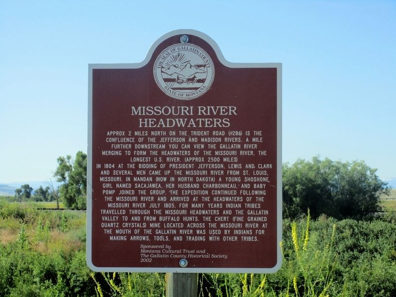
On Frontage Road (County Route 205), on the right when traveling east.
Approx.. 2 miles north on the Trident Road (#286) is the
confluence of the Jefferson and Madison Rivers. A mile
further downstream you can view the Gallatin River
merging to form the headwaters of the Missouri River, the
longest U.S. river. . . . — — Map (db m99206) HM
On North Main Street (State Highway 2) at Cottonwood, on the left when traveling north on North Main Street.
The Headwaters has been populated for over 11,000 years
The Headwaters region was occupied for more than 11,000 years by bands of hunter and gatherers. Ample big game such as bison, elk and deer, and the abundant natural rock for tool . . . — — Map (db m192724) HM
Near Three Forks Airport Road near Frontage Road (State Highway 2), on the left when traveling west.
A native of Three Forks, Montana, born March 16, 1922, Dean Porgerba loved to fly airplanes, especially single engine jets. Dean was a veteran of W.W. II and the Korean War. In his country's third conflict, his plane was shot down over the North . . . — — Map (db m206124) HM WM
On South Main Street near West Cedar Street, on the left when traveling north.
The town of Three Forks, born to serve as a division point for the Chicago, St. Paul, and Milwaukee Railway, took root in 1908. As the town grew to a sizable settlement of 2,300, the Empire Theatre opened to serve local audiences. Manager David R. . . . — — Map (db m192662) HM
On North Main Street (State Highway 2) at West Ash Street, in the median on North Main Street.
This statue was erected to commemorate Sacajawea and the Bicentennial of the Lewis and
Clark Expedition of 1803- 1806. She was a member of the Corps of Discovery and was invaluable as an interpreter in obtaining horses from her Shoshone people, . . . — — Map (db m98496) HM
On North Main Street (State Highway 2) at Cottonwood, on the left when traveling north on North Main Street.
Familiar with the Headwaters area, Sacajawea was invaluable as an interpreter for Lewis and Clark.
In 1800, Sacajawea was camped on the Jefferson River with her Shoshone tribe. Attacked by a band of Minnetarees, she was captured and . . . — — Map (db m192793) HM
On North Main Street at South Main Street, on the right when traveling north on North Main Street.
Arrival of the Milwaukee Railroad caused Three Forks to move (1908-1910) one mile up the Missouri River from its 1863 townsite, as happened with many sister towns in the developing West. Milwaukee Railroad purchasing agent John Q. Adams saw need for . . . — — Map (db m141722) HM
On Trident Road (State Highway 286) 1.5 miles north of Interstate 90, on the right when traveling north.
In front of you is the site of Gallatin City, 1865-1880's. After it became obvious that steamboats could not operate economically from Fort Benton to the Headwaters, the town was relocated from the north side of the river to this location. Sitting . . . — — Map (db m126990) HM
On North Main Street (State Highway 2) near Cottonwood, on the right when traveling north.
"The Nisei bought an awful big hunk of America with their blood." - General Joseph "Vinegar Joe" Stillwell
''You fought the enemy abroad and prejudice at home and you won." - President Harry Truman, July 1946
This memorial is to recognize . . . — — Map (db m192723) HM WM
On North Main Street (Highway 2) at Cottonwood, on the left when traveling north on North Main Street.
Clad in buckskin, the trapper carried with him his knives, gunpowder and lead. a Hawken rifle, perhaps a pipe and a book. Except for flour and salt, he lived entirely off the land. He did his trapping in the spring and fall. During the summer, . . . — — Map (db m192788) HM
On U.S. 287 near Interstate 90, on the left when traveling north.
The Gallatin Valley
While known to Montana First Citizens for Millennia, it was not until William Clark explored the valley in July 1806 that we have the first written description of the Gallatin Valley. Clark described the valley as an . . . — — Map (db m282810) HM
Log cabins were introduced to North America by the Swedes and Germans.
Because they were easy to build and made use of readily available materials, log cabins became the most common building on the frontier.
This cabin has dovetail notches and . . . — — Map (db m127044) HM
On Trident Road (County Route 286), on the left when traveling north.
Many nations traveled and lived along these banks, giving their own names to
the river. “Missouri” is the official name given by the U.S. Geological Survey. It
dates back to French explorer Jacques Marquette’s journal and 1673 map of . . . — — Map (db m99215) HM
On North Main Street (Frontage Road) (State Highway 2) at North 1st Avenue East, on the left when traveling north on North Main Street (Frontage Road).
This region was alive with beaver, otter and game before the white man came. It was disputed hunting territory with the Indian tribes. Sacajawea, the Shoshone squaw who guided portions of the Lewis and Clark Expedition, was captured near here when a . . . — — Map (db m126978) HM
Near Trident Road near Carpenter Road, on the left when traveling north.
On their upstream journey in 1805, Lewis and Clark traveled through this area in two groups. On his return journey in 1806, Clark's group passed through the Headwaters area on their way to the Yellowstone River.
Sites depicted on this map . . . — — Map (db m206117) HM
The Thomas-Frederick Mill was one of two built in the Gallatin Valley during the 1860’s to process locally-grown grains and to guarantee a reliable supply of flour and meal.
Flour from here was freighted regularly to the gold camps of Helena, . . . — — Map (db m127045) HM
On North Main Street (State Highway 2) at Cottonwood, on the left when traveling north on North Main Street.
Easy river access and large numbers of beaver made the Headwaters a logical place for the ... Three Forks Post - 1810
In 1810, Manuel Lisa of the Missouri Fur Co. sent a large party of 32 trappers under command of Pierre Menard . . . — — Map (db m192792) HM
On U.S. 287 near Interstate 90, on the left when traveling north.
Three Forks Post
The Headwaters of the Missouri River were potentially a fur trapper's paradise. Following the return of the Corps of Discovery in 1806, the expeditions's co-leader, William Clark told stories about the abundant beaver . . . — — Map (db m282631) HM
On South Main Street at West Cedar Street, on the left when traveling north on South Main Street.
Solid bank buildings were designed to assure customers that their money was safe from both theft and bank failure—a tenuous premise in the days before Federal Deposit Insurance. Here Romanesque arches, rusticated sandstone, thick masonry walls, and . . . — — Map (db m192663) HM
On North Main Street at South Main Street, on the right when traveling north on North Main Street.
From 38 to 30 million years ago, great herds of rhinoceros-like herbivores, called Megacerops, roamed this part of Montana. Megacerops, also known as Brontotheres, were massive animals. Classified as Perissodactyla, Megacerops had three . . . — — Map (db m213356) HM
On U.S. 287 near Interstate 90, on the left when traveling north.
From 38 to 30 million years ago, great herds of rhinoceros-like herbivores, called Megacerops, roamed this part of Montana. Megacerops, also known as Brontotheres, were massive animals. Classified as Perissodactyla, Megacerops had three . . . — — Map (db m282647) HM
On Trident Road (State Highway 286) 4 miles north of Interstate 90, on the left when traveling north.
In 1908 construction began on Montana’s first cement manufacturing facility. In May 1910, the first cement was shipped to a hardware store in Missoula, Montana. The company-owned village of Trident was built before the plant was completed and at . . . — — Map (db m126996) HM
On North Main Street (State Highway 2) at East Neal Street, on the left when traveling south on North Main Street.
Dedicated to all the men and women
of the Headwaters Area, who gave of themselves
while serving in our armed forces
in times of war and peace — — Map (db m98451) WM
On U.S. 287 1 mile south of Willow Creek Road, on the right when traveling south.
The Montana soil is swallowing hundreds of old homestead buildings like this one. Each takes with it untold stories of men and women whose lives brought them drought and blizzards, loneliness and companionship, fear and simple joys, much like we . . . — — Map (db m127000) HM
Near Lake Hebgen Road (U.S. 287) 12 miles west of U.S. 191.
I've been a pretty tough old bird, but I wouldn’t want to go through that again! Grace Miller August 1959
Survival Tactics
Seventy-something-year-old Grace Miller was a self-professed “tough old bird.” When she found . . . — — Map (db m114166) HM
On U.S. 287 4 miles west of U.S. 191, on the right when traveling west.
On August 17, 1959, this area was hit with the most devastating modern geologic disaster in the Rocky Mountains. An earthquake of a magnitude 7.5 on the Richter scale violently shook the earth, triggering a massive landslide, large surface cracks . . . — — Map (db m113832) HM
On U.S. 287 4 miles west of U.S. 191, on the right when traveling west.
Geologists Irving J. Witkind and Jack Epstein had
uncanny timing on the night of August 17, 1959 the two
U.S. Geological Survey scientists were camped on a small
knoll above Hebgen Lake when their camp trailers began to
bounce “like . . . — — Map (db m113724) HM
On Hebgen Lake Road (U.S. 287) 3.5 miles west of U.S. 191, on the right when traveling west.
By 1898 a 10-foot wide road was built through the Gallatin Canyon to Taylors Fork and the park line. In 1911 a crude, narrow wagon road went to "Yellowstone" (West Yellowstone), 90 miles from the county seat at Bozeman. In 1926, the road was . . . — — Map (db m113833) HM
On Yellowstone Avenue near Dunraven Street, on the left when traveling east.
The Forest Service granted Jess Pierman a special-use permit to build a hotel and restaurant here in 1910. A large tent accommodated guests until the present hotel was under construction in the fall of 1912. Doll Bartlett began cooking for Pierman . . . — — Map (db m255676) HM
On South Canyon Street south of Yellowstone Avenue, on the right when traveling south.
A Celebration that Rolled on the Rails
1964 marked 100 years since Montana was established as a territory. How would the state celebrate this milestone? The challenge to develop a unique showpiece led to the idea of a train that would tour the . . . — — Map (db m239711) HM
On Yellowstone Avenue at Electric Street, on the right when traveling west on Yellowstone Avenue.
Named for the year it was built, the Oregon Short Line 1903 was constructed for $16,685 as an executive rail car for the Vice President of the Union Pacific. In reference to E.H. Harriman's Presidential rail car, the Arden, which was built in 1900, . . . — — Map (db m123346) HM
On Yellowstone Avenue at Canyon Street, on the left when traveling west on Yellowstone Avenue.
In 1905 Union Pacific officials began construction of a branch line in the pine-forested wilderness from Ashton, Idaho, to the western edge of Yellowstone Park. As the final tracks were laid in 1907, Samuel P. Eagle, Alex Stuart, Charles Arnet and . . . — — Map (db m123342) HM
On Hebgen Lake Road (U.S. 287) 14.6 miles west of Gallatin Road (U.S. 191), on the left when traveling west.
On the night of the earthquake about 250 people were camped in the Madison River Canyon.
Their escape was blocked by the highway destruction at Hebgen Lake and the huge slide at the mouth of the canyon.
Realizing they were trapped, most of the . . . — — Map (db m144145) HM
Near State Highway 287 12 miles west of Gallatin Road (U.S. 191).
August 17, 1959: performer Bobbi Baker was on her way to a gig in Billings, Montana when she stopped at the Hilgard Lodge for the night. Just as she settled into bed, she heard a “huge rush of wind” and the cabin began to shake . . . — — Map (db m116142) HM
On Yellowstone Avenue east of Dunraven Street, on the right when traveling east.
Prior to 1936, the roads leading from West Yellowstone were not plowed during the winter months, isolating the town from the rest of the world.
Even the Train Stopped Running
The Union Pacific Railroad provided passenger service to West . . . — — Map (db m126999) HM
On Targhee Pass Highway (U.S. 20), on the left when traveling north.
This basin was settled by ranchers and homesteaders.
Bannock Indians had encampments here as late as 1913. Near
here is the west entrance to Yellowstone Park, the nation’s
first National Park(1872). West Yellowstone was founded in
1908 with the . . . — — Map (db m100066) HM
Near Hebgen Lake Road 14 miles west of Gallatin Road (U.S. 191).
A quiet August night in a popular Forest Service campground just below Hebgen Dam. Nearby Cabin Creek murmurs softly, and the moon filters through the pines.
Abruptly, the ground trembles, then jolts...then with a roar a crack appears, . . . — — Map (db m116506) HM
It began as an idyllic August night. A full moon soared quietly over Yellowstone country. Along Hebgen Lake and the Madison River, campgrounds and vacation cabins were full to capacity, and scores of families were camped by the . . . — — Map (db m113576) HM
On Yellowstone Avenue near Dunraven Street, on the right when traveling east.
As tourism blossomed during the first decades of the twentieth century, the Union Pacific Railroad considered how to better accommodate travelers. Officials conceived the idea of building restaurants and pavilions architecturally similar to the . . . — — Map (db m255675) HM
On Yellowstone Avenue (U.S. 191) at Boundary Street, on the right when traveling east on Yellowstone Avenue.
This Property
Contributes To The
West Yellowstone Oregon
Shortline Terminus
Historic District
Listed In The
National Register
of
Historic Places
By the United States
Department
of
Interior
In Cooperation With
The . . . — — Map (db m103600) HM
On Main Street at 3rd Street, on the left when traveling north on Main Street.
Pioneering Southern Methodist minister Learner Blackman Stateler preached his first sermon in Willow Creek on Christmas Day 1864, in a cabin built by a local farmer. Like many of the area’s early residents, Stateler was a Southern sympathizer from . . . — — Map (db m193003) HM
On Meridian Cemetery Road, on the right when traveling north.
The 1804-1806 Lewis and Clark Expedition named this area "Phlosopher's River." Later it was called Windville. As a girl, Sacajawea, a Shoshone Indian, was captured near here by Minnataree Indians. Later she accompanied and interpreted for the Lewis . . . — — Map (db m193005) HM
On State Highway 287 south of Ruby Road, on the left when traveling north.
The Ruby River was called the Passamari by the Shoshoni Indians and the Stinking Water by the miners in the early 1860's.
Later, it was mistakenly renamed the Ruby, although the gems found along its length were actually garnets.
The . . . — — Map (db m116998) HM
The Madison Valley was well known to mountain men and traders during the first half of the 19th century. Beaver loved the many creeks that emptied into the river and buffalo were common in the valley, making it popular for both Indians and trappers. . . . — — Map (db m141490) HM
On West Fork Madison Road (Forest Road 209) south of U.S. 287, on the right when traveling south.
Few natural events cause as much fear in people as earthquakes. They remind us that the Earth is always changing and renewing itself and that this sometimes occurs violently and without warning. Earthquakes happen when stored energy is suddenly . . . — — Map (db m271543) HM
Motoring was an adventure in the early 20th century and people usually didn't travel very far from home. Most roads were choked with dust during the summers, knee-deep in mud in the rainy seasons, and blocked by snowdrifts in the winters. But as . . . — — Map (db m141491) HM
On U.S. 287 5.7 miles east of State Highway 87, on the right when traveling east.
Imagine… in a blink of your eye …you feel the earth rumble beneath your feet …you watch 80 million tons of rock, half a mountain, crashing down …and then the water begins to rise by your campsite
At 11:37 p.m. on Aug. 17, 1959 a 7.5 earthquake . . . — — Map (db m144146) HM
On Main Street (U.S. 287 at milepost 49) near Prospect Avenue, on the right when traveling north.
The Madison Range rises from the east side of the Madison Valley along an active fault that threads its way along the base of the range. The mountains began to slowly rise along the fault about 50 million years ago and it remains active today. This . . . — — Map (db m192667) HM
On U.S. 287 4.5 miles north of North Ennis Lake Road, on the right when traveling north.
Trailblazers John Bozeman and John Jacobs opened the Bozeman Trail in 1864 as a shortcut between the Overland Road and the newly discovered Montana gold fields.
The trail began near present Casper, Wyoming and ended just over the Bozeman Pass in . . . — — Map (db m117028) HM
On U.S. 287 1 mile east of State Road 87, on the right when traveling east.
The low gap in the mountains on the sky line south of here is Raynolds Pass over the Continental Divide.
Jim Bridger, famous trapper and scout, guided an expedition of scientists through the pass in June of 1860. The party was led by Capt. W. F. . . . — — Map (db m187603) HM
On South Main Street (State Highway 287) near Hamilton Street, on the right when traveling north.
1866 ... first Sunday School.
September 1866 first sermon in Sheridan by Rev. George Comfort.
Summer 1873 Revs. Francis Riggin and Wm. Wesley Van Orsdel (Brother Dan) are appointed to the newly formed circuit headquartered in Sheridan. This . . . — — Map (db m141492) HM
On State Highway 287 0.6 miles south of Ramshorn Creek Road, on the right when traveling south.
Pete Daly built a log roadhouse at this site in 1863. Unlike most roadhouses of the time, which provided meals, companionship and a place to stay for weary travelers, Daly's was allegedly a hangout for Montana's most notorious criminal gang – the . . . — — Map (db m116999) HM
On North Main Street (State Highway 287) at Mill Street, on the right when traveling north on North Main Street.
This small community of Sheridan is located approximately 55 miles south of Butte. Our population is 700 within the town proper, and approximately another 700 in the adjacent Ruby Valley rural area. When those who had come to Virginia City in the . . . — — Map (db m141494) HM
On East Poppleton Street at Jefferson Street on East Poppleton Street.
William O’Brien arrived in the gold-mining and ranching town of Sheridan, Montana, in 1881 and began selling liquor from a small sixteen-by-twenty-foot building. He was one of the town’s three suppliers of “wet groceries” (liquor), the quality of . . . — — Map (db m209428) HM
Browne’s Bridge was constructed as a toll bridge by Fred Burr and James Minesinger in late 1862 and early 1863. The bridge was located on the Bannack to Deer Lodge Road. Joseph Browne, a miner, bought the bridge in 1865. The territorial legislature . . . — — Map (db m180757) HM
On State Highway 41 north of Ridge Road, on the left when traveling north.
Big Wheels
• About 22 ft. dia.
• About 20 tons each
• 22 grooves for 1-1/2 inch rope
• About ½ mile of rope on each wheel
• Originally installed about 1903
• Operated until about 1964
• Erected here in the . . . — — Map (db m128410) HM
On Highway 41 at Ridge Road, on the left when traveling north on Highway 41.
These sheave wheels from the Speculator Mine were used to hoist the bodies of the 168 miners who died in the Granite Mtn. Mine Disaster, June 8, 1917.
It remains the worst metal mining tragedy in U.S. History. The Granite Mtn. shaft was burned . . . — — Map (db m128411) HM
When Captain Meriwether Lewis and his men arrived in the Jefferson River Valley in August 1805, they explored the tributaries of the Jefferson River (today's Beaverhead River), which was named after President Thomas Jefferson. They named it . . . — — Map (db m193123) HM
Explorations of Lewis and Clark 1804-1806
Cartographic Reconstruction
UTM Zone 12
Map Number 262-263
With only a sextant, chronometer, and compass in hand, Captain William Clark was able to map the entire exploration, . . . — — Map (db m193068) HM
On State Highway 41 3.6 miles north of 10th Avenue, on the left when traveling north.
Which Fork to Take?
Meriwether Lewis, traveling ahead with 3 men, reached this spot two days ahead of William Clark and the main parry. After exploring the river courses, Lewis left a note telling Clark to stay on the Jefferson River. Clark . . . — — Map (db m128400) HM
Highway 14 Fairgrounds Road, Twin Bridges, Montana
Early Twin Bridges offered few public gathering places, and so these fifty acres, once part of the Lott and Seidensticker homesteads, were developed as “The Park” in 1887. A “harvest home . . . — — Map (db m193038) HM
WPA engineer C. D. Paxton designed this impressive octagonal community building as part of the federally funded project to rebuild the fairground in 1936. Master log craftsman Tosten Stenberg of WPA headquarters in Livingston supervised the . . . — — Map (db m193044) HM
August 1805 - The Corps of Discovery struggled upriver toward the Rockies. Illness and injury, along with the increasingly difficult river passage, had eroded the group's morale. But the afternoon of the 8th brought a much needed lift, when . . . — — Map (db m193127) HM
Near West 4th Avenue (State Highway 41) 0.1 miles west of Main Street (State Highway 287), on the right when traveling west.
Gold was the key to the success or failure of many of Montana's mining camps in the 19th century. Roads were almost as important as gold because they made possible the movement of supplies, people, and precious metals between the remote territory . . . — — Map (db m127286) HM
Beloved Members of the
Corps of Discovery
This Memorial was made
possible by the generosity of
the
People and Friends of Madison
County
Sculpted by Dick and Sandi Crane — — Map (db m193049) HM
Post-and-beam construction covered with log-veneer siding characterizes this early building inspired by M. H. Lott and built as a community project by area homesteaders in 1894. It is the only remaining building of the original fairground complex, . . . — — Map (db m193039) HM
On State Highway 41 3.6 miles north of 10th Avenue, on the right when traveling south.
In, early August, 1805, the Lewis and Clark Expedition, westward bound, came up the Jefferson River and passed through this area. The valley was an ancient travel corridor; Lewis noted the presence of an "old Indian road" near the Big Hole River. . . . — — Map (db m116997) HM
On North Main Street (State Highway 41) at East 6th Avenue, on the right when traveling north on North Main Street.
Meriwether Lewis, Touissaint Charboneau, Patrick Gass and George Drewyer, the vanguard of the Lewis and Clark Expedition and the first white men to enter this valley, camped on the east bank of the Beaverhead River, two blocks west of here, on . . . — — Map (db m128399) HM
On State Highway 41 at milepost 13, on the right when traveling north.
Both before and since the passage of Lewis and Clark, the limestone outcrop in front of you served as an important landmark and meeting area. The Shoshone tribe, from whom Sacagawea had been kidnapped as a child, came to this area every summer. By . . . — — Map (db m193132) HM
On State Highway 41 at milepost 13, on the right when traveling south.
Many of the rangelands in this valley still look largely as they did even before the Lewis and Clark Expedition walked here. Yet people and animals have traveled through and use the lands around you since prehistoric times. Montana Highway 41, and . . . — — Map (db m193129) HM
As the Corps of Discovery approached this river valley, the convergence of several rivers presented Captains Meriwether Lewis and William Clark with a choice of routes. Lewis and a few men traveled ahead of Clark to investigate the various rivers. . . . — — Map (db m193124) HM
On State Highway 287 0.5 miles north of Brown's Gulch Road, on the left when traveling north.
Alder Gulch at peak population numbered ten thousand souls and the colorful mining camps that enjoyed the limelight were so numerous that contemporaries named it the Fourteen-mile City.
Adobetown was one of the many settlements that lined the . . . — — Map (db m117000) HM
On Jackson Street near West Idaho Street, on the right when traveling south.
Between 1870 and 1880, Virginia City's African American population was small compared to other minorities such as the Chinese. African American freighter Jack "Jarret" Taylor was in town as early as 1866, Sarah Bickford arrived in January 1871, . . . — — Map (db m208756) HM
On Wallace Street (State Highway 287) near West Idaho Street, on the left when traveling west.
The tracks of the Northern Pacific Railroad never really came to Virginia City. Although the town was the first overland transportation hum in the Territory of Montana and an important regional supply center, this status predates the railroad era. . . . — — Map (db m206347) HM
On Wallace Street (State Highway 287) east of Van Buren Street, on the right when traveling east.
The Federal Reserve Bank of Montana identifies the Allen and Millard Bank, which opened here in 1864, as the first real bank in Montana Territory. While other businesses in the Territory called themselves banks, most were actually express companies . . . — — Map (db m128435) HM
On State Highway 287 0.1 miles south of California Street, on the right when traveling south.
The Montana Heritage Commission’s state-owned collection of railroad equipment represents the construction era of railroads in Montana. The wooden Soo Line cars representative of cars used by the Northern Pacific, Great Northern and Union Pacific . . . — — Map (db m128402) HM
On Wallace Street at Jackson Street on Wallace Street.
The oldest section of this building, dating to 1863, was first a simple one-story building which housed a restaurant called the “Young American Eating House.” A butcher shop followed from 1866 to the 1880s, and then in the 1880s the building was a . . . — — Map (db m49474) HM
On West Cover Street near Van Buren Street, on the left when traveling east.
Martin and Anna Lyon came to Virginia City by covered wagon in 1864 and settled into this small dwelling. Martin, a successful tailor, was on his way home in January of 1865 when thieves attacked and fatally struck him over the head. A blizzard . . . — — Map (db m206467) HM
On West Wallace Street near Jackson Street, on the left when traveling west.
Mining is filthy work, a fact that spelled opportunity for African American barber George Turley, who opened a “Fashionable Hair Dressing and Shaving Saloon” in a narrow building on this site. In 1864, Turley advertised bathrooms for miners . . . — — Map (db m208691) HM
On Wallace Street at Van Buren Street on Wallace Street.
Virginia City boomed and land prices soared accordingly in 1863 and 1864, a trend well illustrated in the earliest ownership transactions of this choice commercial property. On May 13, 1864, George Parker paid $800 for the lot and sold it for $1400 . . . — — Map (db m49441) HM
On West Idaho Street east of Van Buren Street, on the right when traveling east.
Dr. Levinus Daems built or purchased the home on the right (West) soon after his arrival in Virginia City in 1863. Born in Belgium, Levinus Daems studied medicine and pharmacy at the University of Paris. While in Paris, he likely met his future . . . — — Map (db m117102) HM
On Wallace Street near Jackson Street, on the left when traveling west.
Like the Picture Gallery, the Elling Store, and several others, this 1946 building and its neighbor to the left are a faithful reconstruction of the originals. The Elephant Auction House occupied these storefronts from summer 1863 until October . . . — — Map (db m208682) HM
This was Virginia City’s first Cemetery. There were many markers here, but only those of the road agents and Daltons remain. The road agent’s graves, which gave the Cemetery its name Boot Hill, were first marked by the city in 1907.
William & . . . — — Map (db m49490) HM
On East Wallace Street (State Highway 287) east of South Broadway Street, on the right when traveling east.
Two small houses shared this choice corner location in 1866, but after 1875, photographs reveal the unmistakable steeply pitched roof and central gable of this splendid Gothic Revival style residence.
Expansion and remodeling during the 1890s . . . — — Map (db m117044) HM
On East Idaho Street at South Hamilton Street, on the left when traveling west on East Idaho Street.
Charles W. Rank arrived on the third train into Bozeman in 1883. There he launched a career in the drug store business that would span more than half a century. In 1884, he came to Virginia City to manage a small drug store. Partnering with his . . . — — Map (db m206279) HM
On Wallace Street near Van Buren Street, on the right when traveling west.
Charles Argalis Bovey ("Charlie") was born May 1, 1907, in Minneapolis, Minnesota into the comfort and social status provided by his father's position as President to the company which would become General Mills. Charlie, however, would find his . . . — — Map (db m208659) HM
On Jackson Street near West Idaho Street, on the right when traveling south.
The history of these two false-fronted cabins, joined by the 1890s, is interwoven with Virginia City’s African-American pioneers. The two separate, 1860s log cabins served both residential and commercial purposes. Minerva Coggswell acquired this . . . — — Map (db m208760) HM
On East Idaho Street at Hamilton Street, on the left when traveling west on East Idaho Street.
This early home, built circa 1868 by C. E. Hill, was reputedly the site of Virginia City’s first Chinese wedding. The two-story section was originally finished in vertical siding, the eaves were trimmed in fancy latticework, and a small porch . . . — — Map (db m206343) HM
On West Cover Street near Van Buren Street, on the left when traveling east.
During Virginia City’s mid-1860s boom, residences and businesses crowded along Cover Street. Most commercial buildings were gone by the mid-1880s and the neighborhood became primarily residential. Irish immigrant Phillip Conrey, a rancher and . . . — — Map (db m206464) HM
On West Wallace Street at Jackson Street, on the left when traveling west on West Wallace Street.
When Solomon Content built this commercial building in 1864, it was one of the area’s most impressive, desirable business spaces. Stucco scored to look like stone originally covered the rubble stone walls, and Gothic transoms lent a civilized . . . — — Map (db m208692) HM
On East Idaho Street at Van Buren Street, on the left when traveling west on East Idaho Street.
The cozy placement of the Corbett and Daems houses has long been a mystery in Virginia City. The log Corbett house was likely built in summer 1863, and the Daems house by early 1864. No records exist explaining why these two middle-class homes sit . . . — — Map (db m206283) HM
On Wallace Street (State Highway 287) at Van Buren Street, on the right when traveling east on Wallace Street.
Brothers John A. and Edward Creighton came west scouting the first transcontinental telegraph lines from Omaha, Nebraska, to the coast.
Temporarily settling in Virginia City, Edward hired Thompson and Griffith to construct this building, the . . . — — Map (db m117047) HM
On East Idaho Street near Van Buren Street, on the left when traveling west.
Though simple by today’s standards, the Daems house exemplifies an upper-middle-class, early-1860s Virginia City dwelling. Dr. Levinus Daems and his wife Marie Daems, a nurse, may have been the first residents of the house. Born in Belgium and . . . — — Map (db m206284) HM
James Stuart and his brother Granville set up the first sluice boxes in the northern Rockies in 1852. Delaware native Walter B. Dance came to Gold Creek in 1862. James Stuart and Dance opened their mercantile in November, 1863. One of Virginia . . . — — Map (db m49442) HM
On Grant Mine Road near Alder Gulch Road, on the left when traveling south.
Two panels make up this marker:
Discovery Park - The Fairweather Party
One spring day in 1863, six men looking for their next big gold strike found it in Alder Gulch, William Fairweather, Henry Edgar, Thomas Cover, Barney . . . — — Map (db m208993) HM
On State Highway 287 0.1 miles south of California Street, on the right when traveling north.
Light timber framing with board-and-batten walls characterizes this early home original to the Nevada City townsite. Inside, the original, well-preserved, muslin-covered walls are a rare example of a frontier decorating technique. The cabin’s . . . — — Map (db m117035) HM
On West Wallace Street (State Highway 287) west of Jackson Street, on the left when traveling west.
The design of this false-fronted wooden shop, built in 1863, includes hand hewn timbers and bay windows which are said to have been Montana's first "show windows.”
The Star Billiard Hall was an early tenant, followed by a shoe dealer and . . . — — Map (db m117093) HM
On Wallace Street near Jackson Street, on the left when traveling west.
The livestock trade was big business in emerging gold towns across the West. In the 1860s when livestock was essential to transportation, owners of liveries (stables) and corrals stood to profit far more than any gold digger. James Gray and Justus . . . — — Map (db m208681) HM
340 entries matched your criteria. Entries 101 through 200 are listed above. ⊲ Previous 100 — Next 100 ⊳