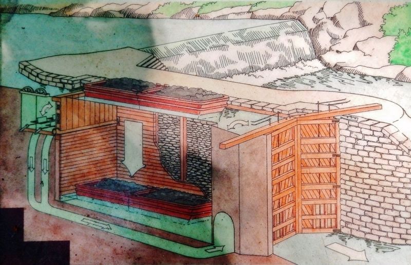
”On June 10, 1838, a boat laden with forty tons of merchandise was carried through the Lehigh navigation from Mauch Chunk to White Haven in fourteen hours, and drawn by one set of horses, and that the locks on said navigation are of a capacity . . . — — Map (db m153403) HM
Marker front:
1861 - 1865
Our country's crisis
Erected
by the citizens of
Weatherly
and vicinity
A.D. 1906
in memory of its noble
defenders
Marker reverse:
"— we here highly resolve that these dead . . . — — Map (db m32078) HM
Dedicate to the honor and sacrifice of our men and women who served their country.
"Let none forget they gave their all and faltered not when came the call."
World War I
1917 - 1918
Francis Deitrich •
Christ J. Luhman •
David G. Eroh . . . — — Map (db m32149) WM
Naturalist and artist John James Audubon visited Rockport in 1829 and hiked the surrounding forests sketching native birds. Already, the transformation was in progress. "One full third of trees have already been culled," he wrote in his . . . — — Map (db m225719) HM
"Since most of the land was donated to the railroads by the American public in the first place, we believe it should be returned to the public." David Burwell, President, Rails-to-Trails Conservancy, 1988 A Well-Worn Path The . . . — — Map (db m225717) HM
Welcome to Lehigh Gorge State Park. This 4,548-acre park stretches 32 miles along the Lehigh River from the Francis E. Walter Dam in the north to Jim Thorpe in the south. Carved by the power of the Lehigh River, the park's deep gorge, steep . . . — — Map (db m114645) HM
1947 Began formal training Allentown & New York City YMCA
1948 Qualified for Olympic trials at age 15 Detroit, MI placed 15 out of 36 competitors
1951 Pan American games Buenos Aires, Argentina gold medal 400-meter freestyle relay . . . — — Map (db m128286) HM
Betty Mullen Brey
November 23, 1931 - March 21, 2015
Upon graduating from Purdue University, Betty received a commission as a Second Lieutenant in the U.S. Army Women's Medical Specialist Corps. Her interest in working with physically . . . — — Map (db m252098) HM
Betty Mullen Brey
November 23, 1931 - March 21, 2015
Betty Mullen Brey was born and raised in Weissport PA, a railroad, river, and canal town with a population of 577. She was the only daughter with four brothers, Dean, Dick, Jack, and Tom. . . . — — Map (db m252102) HM
Welcome to the Delaware and Lehigh National and State Heritage Corridor, a collection of people, places and events that helped shape our great nation. Come journey through five Pennsylvania counties bursting with heritage and brimming with . . . — — Map (db m114644) HM
Erected by Col. Benjamin Franklin in the winter of 1758 at the order of the Province of Pennsylvania. The fort consisting of the two block houses and a well, surrounded by a stockade, was situated 201 feet southwest of this spot. It was used as a . . . — — Map (db m86885) HM
Only remaining part of Fort Allen, which was built by the Province of Pennsylvania, 1756, under the supervision of Benjamin Franklin. The well, now restored, is located directly behind houses opposite. — — Map (db m86879) HM
Almost 250 years before President George Bush designated a department of homeland security to help protect Americans from terrorist attack, Pennsylvania's colonial governor, Robert H. Morris, selected someone known for his great ingenuity to . . . — — Map (db m252095) HM
In memory of Jacob Weiss, born in Philadelphia Sept. 16, 1750. Pioneer, Patriot and Colonel in the American Revolution. This monument is situated 334 yards east of the spot where he built his log cabin in 1783, on the east bank of the Lehigh River. . . . — — Map (db m86888) HM WM
Built in 1756 by the Province of Pennsylvania. One of a series of frontier defenses erected during the French and Indian War. The site was within present Weissport. — — Map (db m86877) HM
"A few miles above Easton, the Lehigh was pocked with white water at almost every turning. To navigate it seemed impossible."
Josiah White, Co-founder of the Lehigh Coal and Navigation Company
As long as the Lehigh Canal prospered, so did Weissport. When the Lehigh Coal and Navigation Company located its primary boatyard here, it transformed both sides of the Canal into a bustling manufacturing complex.
Look around…imagine a . . . — — Map (db m133884) HM
Community landscapes can reveal our past. This part of the Delaware & Lehigh National Heritage Corridor has a lot of stories to tell. You'll see distinctive types of towns. Traditional market towns formed as crossroads commercial centers, . . . — — Map (db m252050) HM
Korea Veterans
• Andreas Clair
• Andreas Robert
• Berger Warren C
• Doll Willard C
• Evert Lyle D
• Frey John A
• Kriner Richard M Jr
• Kurdilla Daniel
• Rehrig Clair N
• Rehrig Dale A
• Rehrig Gene E
• Smith Marvin F
• . . . — — Map (db m247280) WM
World War I 1914-1918
Bachman, Robert C.
• Bailey, Raymond C.
• Bowman, Robert O.
• Mc Farland, James G.
• Neff, Edwin L.
• Neff, George P.
• Rehrig, Howard E.
• Rehrig, Robert R.
• Sarger, Charles M.
• Schoch, Harry H.
• . . . — — Map (db m247289) WM
"Trees one after another were...constantly
heard falling. In a century, the noble
forests around should exist no more."
John J. Audubon
Naturalist
In the woods next to the river are the ruins of the
Lehigh Tannery and a village . . . — — Map (db m163588) HM
Alarmed about draft resistance, the federal government deployed 800 troops to the Fishing Creek Valley in August 1864 to suppress the opposition. Peace Democrats suspected of Confederate sympathies were questioned at the Christian church near this . . . — — Map (db m89911) HM
Dedicated to all firefighters, police officers,
EMS workers and all others
who lost their lives to the tragic events of
September 11, 2001
and all those who carry on.
These metal fragments are
from remains of the Twin Towers that . . . — — Map (db m134844) HM WM
(front)
1747 — Evan Owen — 1819
Purchaser of the Site
and
Founder of the Town.
- First Settlers -
1786
Robert and John Brown
named the town Berwick,
after Berwick-upon-Tweed, England
- Pioneers - . . . — — Map (db m119515) HM
For his distinguished service, unselfish dedication, and tireless efforts to strengthen Berwick. He is an inspiration to all. He has made our community a better place to live, work, and grow. — — Map (db m276883) HM
Name of Shawnee-Delaware Indian village located here. From Braddock's defeat in 1755 until Fort Augusta was built in 1756, it was a rallying point for Indians hostile to the English. — — Map (db m167150) HM
With the faith and courage of
their forefathers who made
possible the freedom of these
United States
The Boy Scouts of America
dedicate this copy of the
Statue of Liberty as a pledge
of everlasting fidelity and
and loyalty
The . . . — — Map (db m119508) HM
During WWII, 9,135 American Car & Foundry workers from the surrounding region produced 15,224 tanks for American and Allied Forces. The first US tank fabricated on an assembly line, the Stuart was favored for its speed and mobility and saw action . . . — — Map (db m134841) HM
In Honor of All
Past And Present
Military Veterans
In Memory of
Thomas S. Cretella M.D.
WW II Veteran Marine-China
11/11/1917 - 11/29/2011
"Doc"
Family Doctor, Berwick PA.
In Honor of
Chief Warrant Officer Four
Joseph . . . — — Map (db m276884) WM
These memorial rose beds
dedicated in commemoration
of our men and women
who served in World War II
Let none forget
they gave their all
and faltered not
when came the call — — Map (db m119529) WM
Dedicated to all men of Berwick and
Vicinity who fought in the World War -
to those who fought and lived, and
those who fought and died; to those
who gave much, and those who gave all.
☆ ☆ ☆ ☆
Arthur Belles • . . . — — Map (db m119513) WM
Formed March 22, 1813 out of Northumberland County. Named in honor of America. County seat, Bloomsburg, became this State's only incorporated town in 1870. A Friends meetinghouse was built at Catawissa about 1789. "Twin covered bridges" at Forks are . . . — — Map (db m89850) HM
The first Columbia County Courthouse was built on this site in 1848. It was designed by Napoleon LeBrun, the same architect who designed the Academy of Music in Philadelphia. The original courthouse is not the core of the building you see here. If . . . — — Map (db m89892) HM
A pin-connected Pennsylvania through truss bridge spanned the north branch of the Susquehanna River at this site from 1894 to 1987. The bridge superstructure constructed of steel and iron by King Iron Bridge Company of Cleveland, Ohio had six . . . — — Map (db m211406) HM
Early in 1781 the McClure house was stockaded by the noted Indian fighter, Moses Van Campen, to protect settlers in this region after destruction of Fort Jenkins in 1780. Site on the north bank of the Susquehanna in present Bloomsburg. — — Map (db m46287) HM
A stockade-type fort was built here in 1778 along Fishing Creek by Moses Van Campen. It served during the Revolution as a refuge against the Indians, by whom it was once attacked. Van Campen was the noted Indian scout of this region — — Map (db m89909) WM
Miquon Chapter
Daughters of the American Colonists
in remembrance of the
Native American inhabitants
here over the past 6000 years.
— — Map (db m163640) HM
Frank Patterson Pursel
Proprietor, (1893-1936)
Frank P. Pursel, Jr. & Charles W.M. Pursel
Proprietors, (1936-1957)
Pursel Store Building Trust
(1957-1975)
Frank P. Pursel, III & Charles W.M. Pursel, Jr.
Owners, (1975-2003)
The "Pursel . . . — — Map (db m119392) HM
With the faith and courage of
their forefathers who made
possible the freedom of these
United States
The Boy Scouts of America
dedicate this copy of the
Statue of Liberty as a pledge
of everlasting fidelity and
and loyalty
The . . . — — Map (db m119324) HM
Plaque 1
This property
has been placed on the
National Register
of Historic Places
By the United States
Department of the Interior
Plaque 2
Rupert Covered Bridge
Columbia County Commissioners
. . . — — Map (db m163642) HM
Rupert Covered Bridge was built in 1847 by Jesse M. Beard at a cost of $1,637. It is located in the village of
Rupert named after Leonard Rupert who established a ferry across the river and his home became a
popular stopping off place for . . . — — Map (db m163644) HM
The Bloomsburg State Normal School Class of 1919 dedicated this memorial to 16 former students - 15 soldiers and a nurse - who died during World War I. It included sixteen trees in the shape of a six-pointed star, one for each of the fallen. By . . . — — Map (db m116477) HM
Freedom — no word was ever spoken that has held out greater hope, demanded greater sacrifice, needed more to be nurtured, blessed more the giver, damned more its destroyer or come closer to being God's will on earth.
General of the . . . — — Map (db m119006) WM
Important path linking the many Indian settlements in the Wyoming Valley with Shamokin, now Sunbury. In 1742 Count Zinzendorf, organizer of Moravian missions, came this way after visiting the Shawnees at Wyoming. — — Map (db m46286) HM
At Catawissa, three miles distant, is the Friends meetinghouse built about 1775. The log structure is still standing and is a fine example of a pioneer place of worship. — — Map (db m257196) HM
[Alphabetically]
Guy Breech 1946-1970 • Ralph W. Brown 1942-1965
Donald E Crane 1941-1965 • Terry R. Hinkle 1948-1968
Alvin L. Levan 1946-1966 • Michael Liptock 1942-1965
Charles K. Malone 1946-1966 • Gary James Palmer 1947-1968
Roger . . . — — Map (db m226468) WM
This 30 foot span Queen Post wooden covered bridge crossed the West Branch of Briar Creek approximately three miles southwest of this site from 1886 to 1986. The bridge was moved to this site by the Pennsylvania Department of Transportation . . . — — Map (db m226478) HM
At one time in Pennsylvania there were at least 1,526 covered bridges, also referred to as "kissing bridges". Today only about 200 remain, which is still more than any other state in the US. The Fowlersville Covered Bridge was built in 1886 by . . . — — Map (db m226481) HM
The nearby friends meeting-house, built about 1775, was the place of worship for early Quaker settlers among the pioneers of this region. Catawissa itself was laid out by William Hughes, a Berks County Quaker. — — Map (db m46230) HM
(Plaque 1)
This property
has been placed on the
National Register
of Historic Places
by the United States
Department of the Interior
(Plaque 2)
Hollingshead Covered Bridge
Columbia County Commissioners
Leroy . . . — — Map (db m163637) HM
"The pin-connected modified Warren truss highway bridge which crossed the Susquehanna River at this site from 1898-1987 had four individual truss spans of 304 feet. These trusses were the longest of any bridge which crossed the Susquehanna River . . . — — Map (db m237555) HM
In Honor of
★ Veterans ★
of All Wars
COMMANDER'S [sic]
★
Dale H. Martz · Walter C. Slusser · Harry Breech · James A. Fegley
William Stellfox · David Fetterman · Max Breech · Max . . . — — Map (db m237550) WM
1940 Chevrolet Fire Truck
Originally owned by the
Ralpho Fire Company, Overlook, PA
Purchased by Knoebels in May 1972
Used for the flood clean-up in June
1972 & various pumping duties since
Body restored in 2007- 2008
Currently . . . — — Map (db m166175) HM
The current Alamo is located in the same
spot as the original restaurant from 1926.
The Alamo was
built during the winter of
1948-49 and
extensively renovated
during the winter of
1999-2000. — — Map (db m280720) HM
The Dodgems were purchased by
Lawrence Knoebel in 1947 and are
considered to be the best bumper car ride
in America today. Over the years
the original cars have been
replaced with Lusse
SKOOTER cars while
the Driving arena has
been expanded. — — Map (db m280724) HM
[plaque]Grand Carousel Purchased: 1941. Opened: 1942 Previous Location: Riverside Park, Rahway, NJ This large 4 abreast carousel was built by George Kremer in 1913 using a Looff platform and horses carved by Charles Carmel. It features 63 . . . — — Map (db m122649) HM
Hand carved in 1913 by master carver Charles Carmel. This carousel was purchased by Knoebels in 1941 and moved here from Rahway, N.J. Its 63 horses and 3 chariots make it one of the largest remaining carousels in the country. — — Map (db m213064) HM
Swimming Hole A natural swimming hole on Roaring Creek attracted the first visitors to Knoebels farm. Admission: With bath house 10¢ Visitors Horse Fed & Stabled 25¢ — — Map (db m122641) HM
The newest Old Covered Bridge in the world, built 1975. "The Park's Beginning" was 100 feet upstream where the original Knoebels Groves Covered Bridge and old swimming hole were located. That bridge was replaced by the modern highway bridge in 1940. — — Map (db m122643) HM
A stockaded house used as a settler's refuge was situated here on the bank overlooking the river, 1778-80, when it was destroyed by the Indians. The land was later owned by James Wilson, an author of the Constitution. — — Map (db m89910) WM
914 entries matched your criteria. Entries 101 through 200 are listed above. ⊲ Previous 100 — Next 100 ⊳