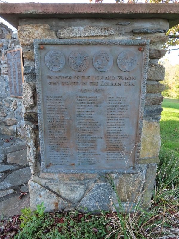
On W Main Street (Connecticut Route 207) at Main Street ( Route 97), on the left when traveling north on W Main Street.
In Honor of the Men and Women
Who Served In the Korean War
1950 – 1953
Arpin Armand · Arpin Walter F. · Avery Arthur · Bastien Gerard · Bastien Napoleon · Bastien William · Benson William D. · Benoit Ronald · Blanchard Hector U. · . . . — — Map (db m141429) WM
On W Main Street (Route 207) at Main Street (Route 97) when traveling north on W Main Street.
( inscribed on the perimeter bricks ) Piekarski, Chester A. Killed In Action September 1944 France
Authier Joseph A. Killed In Action January 1944 Italy
Standish, Walter F. Killed In Action July 1863 Gettysburg, PA . . . — — Map (db m141243) WM
On W Main Street (Route 207) at Main Street (Route 97), on the left when traveling north on W Main Street.
Those That Served Honorably
Dedicated on the 150th Anniversary of the Town of Sprague
World War I
Blanchard, Hector J.
World War II
Adkins, James W. · Anderson, Benjamin H. · Anderson, Robert A. · Arpin, Roderick J. · Baah, Lewis H. · . . . — — Map (db m141222) HM
On W Main Street (Connecticut Route 207) at Main Street ( Route 97), on the left when traveling north on W Main Street.
In Honor of Those Who Served
During the Vietnam Conflict
Andrew, Milton Dennis · Andrew,Robert Harold · Andrzejczyk, Dennis Michael · Arpin, Edward Emile · Arpin, Joseph Adelard, Jr. · Arpin, Raymond Paul · Arsenault, Robert · Baah, Randall . . . — — Map (db m141430) WM
On W Main Street (Connecticut Route 207) at Main Street ( Route 97), on the left when traveling north on W Main Street.
1917 — 1918
Honor Roll of Sprague
Dedicated to Those of Sprague
Who Served Their Country
In the World War
Allard, Alcide · Allard, Joseph H. · Almquist, Arthur · Anderson, Arvid · Anderson, Gustave · Arpin, Odilla · Arseneault, . . . — — Map (db m141218) WM
On W Main Street (Connecticut Route 207) at Main Street ( Route 97), on the left when traveling north on W Main Street.
To the Men and Women of the
Town of Sprague Conn.
Who Served Their Country in World War II
The Following Men Made the Supreme Sacrifice
Authier Joseph A. · Courtmanche Nelson · Ezepchik Edward · Marcil Alonzo · Piekarski Chester A.
Adams . . . — — Map (db m141226) WM
On Main Street (Connecticut Route 97) at Bushnell Hollow Road ( Route 138), on the left when traveling north on Main Street.
You are standing above the Baltic Mill headrace — the channel that fed water to the turbines in the Baltic cotton mill. The headrace reached from the stone bulkhead, to your left, to the back of the mill, some 800 feet to your right.
The . . . — — Map (db m141431) HM
On Water Street at Omega Street, on the right when traveling south on Water Street.
This Is To Remember
Here the Brave Men of Stonington
Defeated a Landing Force From
His Majesty’s ship “Ramillies”
Bent on Burning the Town and its Shipping
August 10, 1814
The Warden and Burgesses of the
Borough of . . . — — Map (db m68420) WM
On North Water Street (U.S. 1A) at Palmer Street, on the right when traveling north on North Water Street.
Captain Nathaniel B.
Palmer House
Built 1852
Has Been Designated A
National Historic Landmark
This Building Possesses National Significance
In Commemorating the History of The
United States of America
1996
National Park Service . . . — — Map (db m68735) HM
On Main Street south of Pearl Street, on the right when traveling north.
This tablet
marks the right of way
of the
First railroad
operated in Connecticut
Chartered May 1832
Opened for service
between Providence and
Stonington Steamboat Dock
. . . — — Map (db m291818) HM
On North Main Street at Palmer Street, on the right when traveling south on North Main Street.
East Face When Rhode Island by her legislation frm 1844 to 1850, Repudiated her Revolutionary Debt. Dr. Richmond removed from that State to this Borough and selected this as his Family Burial Place unwilling that the remains of himself . . . — — Map (db m30982) HM
On Elm Street 0.1 miles south of Meadow Avenue, on the right when traveling south.
Since 2010, Stonington residents have enjoyed harvesting their own organically-grown produce at Stonington Human Services Community Garden. Following input from residents and discussions with the team at Human Services, we saw we had a new . . . — — Map (db m226904) HM
On Water Street at Cannon Square, on the right when traveling south on Water Street.
The
defenders of
the fort
Aug. 10, 1814.
Geo. Howe Fellowes.
who nailed the flag to the mast.
Amos Denison, Jr.
Jere. Haley.
Simeon Haley.
Jere. Holmes.
Seth C. Leonard.
Asa Lee.
Thos. Wilcox.
William Potter.
Hotatio G. . . . — — Map (db m68421) HM WM
On Elm Street 0.1 miles south of Meadow Avenue, on the right when traveling south.
Here we honor the men and women of the Town of Stonington who have served in the armed forces of the United States. And here we record the names of those who so valued the freedoms won by past generations and so dedicated themselves to the . . . — — Map (db m226905) WM
On Elm Street 0.1 miles south of Meadow Avenue, on the right when traveling south.
This memorial made possible by the untiring efforts of the J.F. Trumbull, Woman's Relief Corps No. 34 - Dedicated Nov. 11, 1930 by James W. Harvey Post No. 58 the American Legion.
— — Map (db m226915) WM
Near Greenmanville Avenue (Connecticut Route 27) south of Bruggeman Place, on the left when traveling north.
Hobart Ford, Jr.
Gunners Mate 2nd Class
Attached to U.S.S. LST-531
Born September 17th, 1924
Lost in Action at Sea
April 29th, 1945 — — Map (db m227133) WM
Near Greenmanville Avenue south of Rossie Pentway, on the left when traveling north.
When Clay Burkhalter was growing up in nearby Stonington Harbor, he never dreamed he would someday build a boat, sail it alone across the ocean, and become one of only five Americans to complete a grueling race named the Mini Transat. Burkhalter . . . — — Map (db m227057) HM
Near Greenmanville Avenue (Connecticut Route 27) south of Bruggeman Place, on the left when traveling north.
Built in 1928 for the Danish Lighthouse and Buoy Service, the Gerda III appears to be a common workboat. But in October of 1943, as the persecution of Danish Jews began, this lighthouse tender played a much more important role. . . . — — Map (db m226929) HM
On Greenmanville Avenue (Connecticut Route 27) south of Rossie Pentway, on the left when traveling north.
On July 24, 1992, at 3:30 PM, Dwight Collins, then 34, of Darien, CT, stepped ashore at Plymouth, England, after 40 days at sea in this 24-foot human-powered pedal boat Tango. Collins had departed St. John's, Newfoundland, Canada, on June . . . — — Map (db m227172) HM
Near Greenmanville Avenue (Connecticut Route 27) south of Hinckley Street, on the left when traveling north.
This is a garden of perennials used and valued by African American individuals and communities. Enslaved people brought from Africa to work in households and plantations in the Americas brought their own traditional knowledge with them, and in . . . — — Map (db m227094) HM
Near Greenmanville Avenue (Connecticut Route 27) south of Rossie Pentway, on the left when traveling north.
An Aquinnah Wampanoag History of a Whaling Ancestor
by Elizabeth James Perry
"The Aquinnah Wampanoag are the Indigenous people of Noepe, or Martha's Vineyard. Wampanoag men apprenticed English colonists to learn boat . . . — — Map (db m227091) HM
Near Greenmanville Avenue (Connecticut Route 27) north of Isham Street, on the left when traveling north.
This large, green diesel marine engine weighs 7.5 tons and was appropriately named after the Greek god who was strong enough to carry the world on his back. It is a direct drive engine with planetary reversing gear, which means that it is able to . . . — — Map (db m227162) HM
Near Greenmanville Avenue at Bruggeman Place, on the right when traveling south.
The fire department of Block Island, Rhode Island, used this Gleason & Bailey hand-pumped fire engine during the mid-nineteenth century. Manufactured in the 1850s, this is a typical "crane neck, piano body fire engine." When an alarm sounded, . . . — — Map (db m263325) HM
Near Greenmanville Avenue (Connecticut Route 27) at Bruggeman Place, on the right when traveling south.
This 7,000 anchor was salvaged off Newport, Rhode Island. Its size and shape match British Admiralty specifications for a bower anchor of a 74-gun ship of the line during the American Revolution and War of 1812. It was probably lost by one of . . . — — Map (db m68308) HM
On Greenmanville Avenue (Connecticut Route 27) south of Bruggeman Place, on the right when traveling south.
This building was built about 1863 as the George Greenman & Co. store. The store, which sold produce and other goods to the shipyard and mill employees and nearby families until the 1880s, was located on the first floor, with living quarters for . . . — — Map (db m114846) HM
Near Greenmanville Avenue (Connecticut Route 27) south of Hinckley Street, on the left when traveling north.
Built: 1987, Mystic Seaport Museum
Length: 20'
Beam: 10'
The Breck Marshall is a reproduction of a Cape Cod catboat as built by the Crosby family of Osterville, Massachusetts; at the end of the . . . — — Map (db m227015) HM
On Greenmanville Avenue (Connecticut Route 27) north of Bruggeman Place, on the left when traveling north.
Paul Cuffe was the son of Ruth Moses, a Wampanoag woman, and Kofi Slocum* a man from West Africa brought to Massachusetts as an enslaved person. Kori gained his freedom, but died when Paul was young. Paul began a career at sea at the age of 14 on . . . — — Map (db m227102) HM
Near Greenmanville Avenue south of Hinckley Street, on the left when traveling north.
Americans' prevailing beliefs about humans' place in the natural world have shifted dramatically since the active whaling years of the Charles W. Morgan. A century ago most Americans saw the ocean's seemingly boundless resources solely as . . . — — Map (db m227018) HM
Near Greenmanville Avenue at Bruggeman Place, on the right when traveling south.
This is a replica of a cabin that Captain John Tinkham built for his 20-year-old wife Clara in 1875. She had chronic seasickness and headaches, and he hoped fresh air on deck would help. Clara suffered for a year and a half before finally leaving . . . — — Map (db m263316) HM
On Greenmanville Avenue (Connecticut Route 27) south of Hinckley Street, on the right when traveling south.
This house was built in 1841 for Clark and Harriet Greenman.
Clark was the second oldest of the three brothers who founded the George Greenman & Co. Shipyard. The oldest brother, George, built the house on your left in 1839. The youngest . . . — — Map (db m114826) HM
Near Greenmanville Avenue (Connecticut Route 27) south of Hinckley Street, on the left when traveling north.
Whaling voyages created opportunities for cultural exchange between crew from all corners of the globe. Sailors used whaleships to emigrate when whaling vessels routinely stopped and picked up crew in remote places such as Valparaiso, Cape Verde, . . . — — Map (db m227049) HM
On Greenmanville Avenue (Connecticut Route 27) at Bruggeman Place, on the right when traveling south on Greenmanville Avenue.
We believe this house was built in the 1840s. George Greenman & Co. rented its two apartments to employees of the company's shipyard and textile mill. In the 1850s and 1860s it was occupied by the widow of a mill employee and the minister of the . . . — — Map (db m114845) HM
Near Greenmanville Avenue (Connecticut Route 27) south of Rossie Pentway, on the left when traveling north.
The Cruising Club of America is a group of accomplished recreational offshore sailors bound together by friendship and the desire to foster the responsibilities, expertise, and skills needed for the adventurous use of the sea.
Members . . . — — Map (db m227068) HM
Near Greenmanville Avenue (Connecticut Route 27) south of Bruggeman Place, on the left when traveling north.
How did people in Cincinnati, Ohio, get saltwater fish for their chowder in the days before refrigeration and canning? They probably bought a small box of salted, dried fish caught in the Atlantic months before.
Fishermen on the L.A. . . . — — Map (db m227129) HM
On Greenmanville Avenue (Connecticut Route 27) at Rossie Street, on the right when traveling south on Greenmanville Avenue.
This house was built in 1839 for George and Abigail Greenman. He was the oldest of the three brothers who founded the George Greenman & Co. Shipyard. The three brothers lived here until Clark Greenman built his house next door on your right in . . . — — Map (db m114829) HM
Near Greenmanville Avenue (Connecticut Route 27) south of Bruggeman Place, on the left when traveling north.
Built: 1925, John F. James & Son, Essex, MA
Length: 137'
Beam: 25'
After a century of service, the Grand Banks fishing schooner Roseway is here at Mystic Seaport Museum for a major preservation . . . — — Map (db m226931) HM
Near Greenmanville Avenue (Connecticut Route 27) south of Rossie Street, on the left when traveling north.
Horsepower: 7
Cylinders: 1
This simple single-cylinder (one-lung) engine with flywheel is typical of tens of thousands found all over rural America after their introduction in the 1890s. They powered small . . . — — Map (db m227098) HM
Near Greenmanville Avenue north of Bruggeman Place, on the left when traveling north.
For generations, the tribes of Quinnehtukqut (Connecticut) have been connected to the animals and fish of the sea. This connection led them to become boat builders.
What is a mushoon?
Commonly known as a dugout canoe in the . . . — — Map (db m227099) HM
Near Greenmanville Avenue (Connecticut Route 27) south of Bruggeman Place, on the left when traveling north.
Feeding a Growing Nation
Between 1865 and 1930, New England fishing schooners sailed to the North Atlantic's rich fishing banks, where phytoplankton flourish in shallow waters and attract cold-water fish. The L.A. Dunton fished there . . . — — Map (db m227105) HM
Near Greenmanville Avenue (Connecticut Route 27) south of Bruggeman Place, on the left when traveling north.
Working in Extreme Conditions
The captain and crew of the Dunton faced danger every day at sea. Fishing in the North Atlantic was physically exhausting work, done in tight quarters and rough conditions. Voyages lasted between one and . . . — — Map (db m227125) HM
On Greenmanville Avenue (Connecticut Route 27) south of Rossie Street, on the right when traveling south.
Part of this house was standing when brothers George, Clark, and Thomas Greenman purchased the surrounding land in 1837 and founded the George Greenman & Co. Shipyard.
They lived here until George Greenman built the house on your right in 1839. . . . — — Map (db m114834) HM
On Greenmanville Avenue (Connecticut Route 27) south of Bruggeman Place, on the right when traveling south.
This house was built about 1841 by Welcome B. Lewis (1810-1880), a ship carpenter who often worked at the George Greenman & Co. Shipyard. Originally sided with clapboards and painted white, the house was built in the Greek Revival style then . . . — — Map (db m114847) HM
Near Greenmanville Avenue (Route 27) at Rossie Street, on the left when traveling north.
Blacksmithing and metal work has always been a much-revered occupation in West Africa and it was one of the few skilled trades open to enslaved men before emancipation. Lewis Temple was a 19th-century blacksmith and innovator who was born in . . . — — Map (db m226992) HM
Near Greenmanville Avenue (Connecticut Route 27) at Bruggeman Place, on the right when traveling south. Reported permanently removed.
This tree grew on the coast of South Carolina for over 600 years, until it was blown over by Hurricane Hugo in 1989. With help from the Gervais family, Mystic Seaport workers salvaged the tree along with ten trailer loads of prized live oak. . . . — — Map (db m68520) HM
On Greenmanville Avenue (Connecticut Route 27) north of Isham Street, on the left when traveling north.
This tree grew on the coast of South Carolina for over 600 years, until it was blown over by Hurricane Hugo in 1989. With help from the Gervais family, Mystic Seaport Museum workers salvaged the tree along with ten trailer loads of prized live . . . — — Map (db m227166) HM
Near Greenmanville Avenue (Connecticut Route 27) at Bruggeman Place, on the left when traveling north.
Lobstermen and dealers kept lobsters alive in floating wooden crates called "cars" to await either being sent to market or sold at the right time for better prices. This car is a reproduction of the large one used by dealers around 1890. As many as . . . — — Map (db m226980) HM
Near Greenmanville Avenue at Bruggeman Place, on the right when traveling south.
Maine Sloop Boat Estella A Built: R.E. (Rob) McLain Long Island, ME, 1904 Length: 34'5" Beam: 11'9" A century ago, there were hundreds of sail-powered lobster boats like this one, swinging from moorings in nearly every Maine harbor. The . . . — — Map (db m263855) HM
Near Greenmanville Avenue (Connecticut Route 27) at Bruggeman Place, on the right when traveling south.
In Memory Of
George Greenman 1805 - 1891
Clark Greenman 1808 - 1877
Thomas S. Greenman 1810 - 1887
Master shipbuilders. Sons of Silas Greenman, shipbuilder, of Westerly, R.I. They established their first yard at the head of the Mystic . . . — — Map (db m68506) HM
Near Greenmanville Avenue (Connecticut Route 27) south of Rossie Pentway, on the left when traveling north.
During the era of whaling and beyond, New England vessels frequented the Arctic to engage in hunting and trade. Born in Maryland in 1866, African American seaman Matthew Henson signed on as cabin boy aboard the merchant ship Katie Hines. . . . — — Map (db m227086) HM
Near Greenmanville Avenue near Bruggeman Place, on the right when traveling south.
In Remembrance of the Self-Reliant
Men and Women of Our Early Seaports
Whose Courage, Devotion and Hardy Industry
Set an Example of Useful Achievement
Unsurpassed In History
Mr. and Mrs. Frederick F. Brewster
Contributed to the . . . — — Map (db m263857) HM
On Main Street (Connecticut Route 27) just south of Old Mystic Center Road ( Route 27), on the right when traveling south.
Mystic Bank has been placed on the National Register of Historic Places in 2014 by the United States Department of the Interior. — — Map (db m227175) HM
Near Greenmanville Avenue (Connecticut Route 27) north of Hinckley Street, on the left when traveling north.
Located in Pequot territory and used for millennia by Indigenous people, it was later colonized by Europeans who displaced local Indigenous peoples. Mystic is also the notorious site of one the most brutal massacres of Indigenous people in . . . — — Map (db m227055) HM
Near Greenmanville Avenue (Connecticut Route 27) south of Rossie Street, on the left when traveling north.
The Mystic Seaport Museum Sailing Center opened in 1961 and serves as the classroom space for the Museum's sailing and overnight programs. Students and campers in our overnight programs sleep next door on our tall ship the Joseph Conrad. . . . — — Map (db m226984) HM
Near Greenmanville Avenue (Connecticut Route 27) south of Bruggeman Place, on the left when traveling north.
This simple shed served as the toilet for shipwrights at the shipyard established by Herbert Newbert and Leroy Wallace in 1942. the yard specialized in building fishing vessels, including the eastern-rig dragger ROANN, which is . . . — — Map (db m226974) HM
Near Greenmanville Avenue (Route 27) south of Hinckley Street, on the left when traveling north.
19th-century commercial whaling was a volatile, high-risk, and high-profit industry of the kind often identified as a distinctly American practice. It had a devastating impact on some of the world's whale populations and a contradictory impact on . . . — — Map (db m227017) HM
Near Greenmanville Avenue (Connecticut Route 27) at Bruggeman Place, on the right when traveling south. Reported permanently removed.
Mystic Seaport’s lighthouse is a reproduction of Nantucket Island’s Brant Point Lighthouse. Built in 1966, it is an exact replica in size and scale and uses a fourth order Fresnel lens.
Only the second lighthouse built in the English American . . . — — Map (db m68510) HM
Near Greenmanville Avenue (Route 27) south of Rossie Street, on the left when traveling north.
Mystic Seaport's lighthouse is a reproduction of Nantucket Island's Brant Point Lighthouse. Built in 1966, it is an exact replica in size and scale and uses a fourth-order Fresnel lens.
Only the second lighthouse built in the . . . — — Map (db m226983) HM
On Greenmanville Avenue at Bruggeman Place, on the right when traveling south on Greenmanville Avenue.
Built: 1964, Electric Boat, Groton, CT Length: 16' Weight: 4.5 tons Maximum speed: 4 knots This little submarine played a giant role in the field of underwater archaeology. It was commissioned by archaeologist George F. Bass, a leader in . . . — — Map (db m263322) HM
Near Greenmanville Avenue (Connecticut Route 27) south of Bruggeman Place, on the left when traveling north.
The L.A. Dunton has belonged to Mystic Seaport Museum since 1963 and was recently hauled out for a major, multiyear restoration.
Visit the Shipyard Gallery for updates and to learn more about restoring historic ships and tools and . . . — — Map (db m227127) HM
On Greenmanville Avenue (Connecticut Route 27) north of Isham Street, on the left when traveling north.
Here at Mystic Seaport Museum, we produce our own lumber from logs. It is more economical and provides us with the correct moisture content and unusual sizes we need. White oak, yellow and white pine, spruce, fir, and hackmatack are all used in . . . — — Map (db m227156) HM
On Greenmanville Avenue (Connecticut Route 27) north of Bruggeman Place, on the left when traveling north.
Built: 1932, Henry B Nevins, Inc., City Island, NY
Design: Sparkman & Stephens, Inc.
Length: 61'6"
Sparred Length: 74'
Rig Height: 81'
Draft: 9'8"
Beam: 14'8"
On Greenmanville Avenue (Route 27) north of Isham Street, on the left when traveling north.
The shipsaw is a type of bandsaw. The blade is a thin steel band that is turned at a high rate of speed by large wheels. Most bandsaws have a table that tilts to change the angle of the cut. This is convenient if the piece of wood is small enough . . . — — Map (db m227146) HM
Near Greenmanville Avenue at Bruggeman Place, on the right when traveling south.
The Amistad is a replica of the coastal schooner that was used to transport slaves from Havana to sugar plantations on the coast of Cuba. It was built in the Mystic Seaport Museum Shipyard and commissioned in 2000. It is the flagship of . . . — — Map (db m263313) HM
Near Greenmanville Avenue (Connecticut Route 27) north of Isham Street, on the left when traveling north.
Why does Mystic Seaport Museum need a Shiplift?
Vessels such as the Charles W. Morgan need to be taken out of the water for regular repair, maintenance, and restoration. With this Shiplift, Mystic Seaport Museum can perform work on . . . — — Map (db m227135) HM
Near Greenmanville Avenue (Connecticut Route 27) south of Hinckley Street, on the left when traveling north.
Built and launched in New Bedford in 1841, the Charles W. Morgan is the last of an American whaling fleet that numbered more than 2,700 vessels over 150 years. During an 80-year whaling career, the Morgan embarked on 37 voyages. . . . — — Map (db m227038) HM
Near Greenmanville Avenue (Connecticut Route 27) north of Rossie Street, on the left when traveling north.
All the flowers and shrubs in this garden were in general use during the 1830s and 1840s.
In 1835, as President Jackson was growing citrus trees and tropical flowers in the White House greenhouses, the Buckinghams and other American . . . — — Map (db m227097) HM
Near Greenmanville Avenue (Route 27) at Bruggeman Place, on the left when traveling north.
During the era of slavery, African Americans played a major role in oystering. Thomas Downing, a notable abolitionist who was the "Oyster King" of New York City, built an empire out of an oyster bar. He made his fortune in oysters as an . . . — — Map (db m226979) HM
On Greenmanville Avenue (Connecticut Route 27) at Hinckley Street, on the right when traveling south on Greenmanville Avenue.
This house was built in 1842 for Thomas and Charlotte Greenman. Thomas was the youngest of the three brothers who founded the George Greenman & Co. Shipyard. The oldest brother, George, built the house two doors to your left in 1839. The middle . . . — — Map (db m114807) HM
Near Greenmanville Avenue (Connecticut Route 27) south of Rossie Pentway, on the left when traveling north.
Length: 25'
Beam: 6'
This fiberglass Japanese fishing boat was swept out to sea during the deadly March 11, 2011 Japanese earthquake and tsunami, then drifted across the Pacific Ocean for a decade. It landed . . . — — Map (db m227088) HM
Near Greenmanville Avenue at Bruggeman Place, on the right when traveling south.
U99.9 (now known as Miss Budweiser) Built: 1992, Unlimited Boats Length: 29′ 4″ Beam: 14" This is a hydroplane racing boat, which was powered by a Lycoming T-55 Chinook helicopter turbine engine. The sleek hull is . . . — — Map (db m263912) HM
Near Greenmanville Avenue (Connecticut Route 27) south of Rossie Pentway, on the left when traveling north.
"The water brought us here: the water will take us home" - Ebo Tribesman
West Africa is the home of ancient maritime traditions. West Africans built and used boats for fishing, transportation, trade, . . . — — Map (db m227089) HM
Near Greenmanville Avenue at Bruggeman Place, on the right when traveling south.
This huge wooden tank for freshwater came from the three-masted Pacific Coast schooner Beulah. It is 14 feet long and almost 6 feet high, built of California redwood. As with smaller wooden barrels, the staves are held together entirely by . . . — — Map (db m263324) HM
Near Greenmanville Avenue north of Rossie Street, on the left when traveling north.
Travel aboard a ship was often a much safer route to freedom than attempting an escape from enslavement on land. Some of the Underground Railroad's bravest conductors were sea captains. Escape by sea required much ingenuity. In 1854, . . . — — Map (db m226993) HM