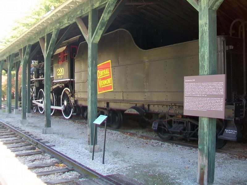
Locomotive 220 was the last coal-burning steam ten-wheeler used on the Central Vermont Railway. As a medium-sized engine it moved both freight and passenger trains and became known as the [sic] "The Locomotive of Presidents" for its use on special . . . — — Map (db m109152) HM
The Rail Locomotive No. 220, built in 1915 by the American Locomotive [C]ompany of Schenectady, New York, was the last coal-burning, steam ten-wheeler used on the Central Vermont Railway. As a medium-sized 4-6-0 engine (4 leading wheels, 6 driving . . . — — Map (db m109153) HM
Charlotte Meeting House was built by the community's Methodist congregation. The building's architectural details reflect Greek design influences, including the triangular pediment created by cornice moldings. During the building's 112-year history . . . — — Map (db m109101) HM
Northwest of this site in 1770
Moses Pierson
who owned the surrounding thousand
acres built his home.
On March 12, 1778 it was attacked by sixty British and Indians but was defended by the Piersons, Colonel Thomas Sawyer, Lieutenant . . . — — Map (db m247335) HM
Originally used for ticketing, information, and the museum store, Owl Cottage today is a lively center for hands-on experiences for children. Toys, books, games, and craft activities engage visitors of all ages. — — Map (db m109438) HM
The Pleissner Gallery was built to honor Brooklyn-born artist Ogden Minton Pleissner (1905-1983), a close friend of the Webb family who earned national recognition for his work as a war artist, landscape painter, and talented chronicler of sporting . . . — — Map (db m109432) HM
This two-story saltbox home is built around a massive central chimney with seven flues that meet on the second floor in a beehive-shaped form. John Dickinson built Prentis House on four acres where he and his family farmed broomcorn.
Prentis . . . — — Map (db m109157) HM
The Prentis House was discovered in Hay Massachusetts in a regional quest for architectural parts, in the search for large floorboards with which to finish off the Stencil House. Hugh Sloan, a sell described "real estate dealer and a dabbler in . . . — — Map (db m259176) HM
Preservation of the Colchester Reef Lighthouse for future generations was made possible by a gift from Frederick A. McCarthy in loving memory of his mother Myrtle Button who was born in the Lighthouse in 1888 — — Map (db m109471) HM
Constructed from historic timbers, the Print Shop exhibits a range of printing equipment that might have been found in an early 20th-century small-town print shop, from an 1820s handpress to a 1950 high-speed Heidelberg press. Late 19th-century . . . — — Map (db m109207) HM
Dr. William Seward Webb (1851-1926), president of the Rutland Railroad and the Wagner Palace Car Company, lived for part of the year in Shelburne, commuting to New York City in his own private car, the Ellesmere, which was similar to the . . . — — Map (db m109371) HM
Built in 1890 by Rutland Railroad President Dr. William Seward Webb (1851-1926), the Railroad Station was originally located near the center of Shelburne to serve passengers of the Central Vermont and Rutland Railroads. Designed by architect Robert . . . — — Map (db m109368) HM
The three-story Round Barn was built in 1901 to improve agricultural efficiency on the farm. Hay from the top floor and silage from the central silo dropped through feed chutes to the middle level, where up to sixty cows could be stanchioned around . . . — — Map (db m109520) HM
The Sawmill building houses the Trescott-Shepard sawmill originally located in South Royalton, Vermont. The water-powered mill was built in the late 1700s on Mill Brook by Jeremiah Trescott and his partner, Captain Stevens. Trescott's descendants, . . . — — Map (db m109483) HM
The one-room Schoolhouse was the first structure moved to the Museum. The building has several distinct classical architectural features, including a projecting bell tower, arched door opening, and sash windows. The structure originally stood on . . . — — Map (db m109087) HM
The Settlers' House is constructed of hand-hewn beech and pine timbers. In the 18th and early 19th centuries, Vermont settlers, loggers, and trappers often built similar temporary log homes. Research suggests that this particular example was . . . — — Map (db m109479) HM
This building originally served a large Shaker community in Canterbury, New Hampshire, as a one-story horse and carriage stand. The simple, unadorned commercial structure was expanded in 1850 to provide storage space for brooms made and sold by . . . — — Map (db m109172) HM
Scripture
1800 • The First Society
Tradition
1834 • The Brick Church
Experience
1872 • The Stone Church
Reason
2000 • The Bicentennial Addition — — Map (db m109237) HM
Smokehouses are small, airtight stone structures where meat was preserved. Traditionally, butchered cuts were salted and then hung in a smokehouse above a smoldering fire of corn cobs and hickory wood. Meats remained in place for several days, or . . . — — Map (db m109223) HM
Hezekiah Barnes, a U.S. militia captain turned road surveyor, strategically located his inn and trading post in Charlotte on opposite sides of the main stage route from Montreal. Built in the Georgian style, the exterior of the inn features . . . — — Map (db m109219) HM
The Stencil House is typical of small side-gabled homes common in New York and New England. The floor plan groups four rooms around a central chimney. A central front door, flanked by pairs of double-hung windows, opens into a small entrance hall. . . . — — Map (db m109132) HM
Stone Cottage is constructed of limestone laid in straight courses rather than in the more common scatterstone technique. It was originally built as a farmhand's house; the first tenants were a family of five, including husband and wife, two . . . — — Map (db m109083) HM
Begun in 1957, Beach Lodge was one of the final
construction projects completed before Electra
Webb's death in 1960. She celebrated the gift of
paintings artifacts, and hunting trophies from
her friends and hunting companions. William
and Marie . . . — — Map (db m259866) HM
The Rail Car Grand Isle (1899) was one of the last private cars built by the Wagner Palace Car Co. before Pullman took control of the company at the end of 1899. The car was used by Dr. William Seward Webb and the Rutland Railroad until 1914, when . . . — — Map (db m109379) HM
1906•Shelburne, Vermont•Original owner: Champlain Transportation Company •Moved to museum: 1955 The 220-foot Ticonderoga is America's last remaining walking beam side-wheel passenger steamer, and a National Historic Landmark. Serving a . . . — — Map (db m97385) HM
Built adjacent to the Variety Unit to reflect the "continuous architecture" building style common throughout New England, the Toy Shop displays an array of children's playthings: transportation toys, mechanical banks, an operating model train, dolls . . . — — Map (db m109085) HM
This brick farmhouse is the only historic structure at the Museum original to the site. A rambling building, its complex structure consists of a series of one- and two-room additions to the original farmhouse in the New England "continuous . . . — — Map (db m109086) HM
This intimate stone structure is a conjectural restoration and reconstruction of an original log framed house built in Shelburne in the late 18th century.
Vermont House features Something Old, Something New: Continuity & Change, American . . . — — Map (db m109158) HM
Constructed using historic building materials, the Weaving Shop exhibits a variety of hand-spinning and weaving equipment and interprets American textile traditions practiced in a 19th-century weaving shop.
On view are processing . . . — — Map (db m109174) HM
This building was designed to complement neighboring historic structures. The main block, flanked by matched wings, echoes the symmetry and scale of nearby Dorset House, and the brick façade reflects the construction materials of the Schoolhouse . . . — — Map (db m109476) HM
Shelburne Museum's founder Electra Havemeyer Webb (1888-1960) was a pioneering collector of American folk art who established the Museum in 1947 to celebrate, in her words, "the art of everyday people" and to create "an educational project, varied . . . — — Map (db m109010) HM
Pleasant View Farm's White Farmhouse
The land forming the University of Vermont Miller Research and Educational Center has been used for agricultural purposes since 1763, when it was deeded to Jacob Kirbee by Royal Land Grant. By 1823, Eleazer . . . — — Map (db m151132) HM
The Old Schoolhouse was once one of 15 one-room schools serving Underhill. The first school building for Underhill Center was built on this site in 1820 and was replaced in 1836 by another school, which was destroyed after it served as a . . . — — Map (db m151135) HM
Scottish-born Udney Hay was a timber merchant
in Quebec who joined the 2nd Canadian Regiment of
Colonel Moses Hazen in January 1776 to support the
American colonies in the fight for independence. He
was appointed assistant deputy quartermaster . . . — — Map (db m305682) HM
Near this site in 1773 the first settlers Ira Allen and his uncle Remember Baker built of hewed timbers the block house called Fort Frederick as a protection from Indians and Yorkers
It had 32 port holes and in it were held the meetings of . . . — — Map (db m79911) HM
Hood's Crossing
In 1849, the Vermont Central Railroad was built
through Winooski, crossing East Allen Street. The
street followed a late-18th-century road connecting
Burlington and the village of Winooski Falls to hamlets
and farms in . . . — — Map (db m261840) HM
Imagine a time machine taking us back to this spot 500 years ago. We would see a deep, rocky waterfall now hidden under the ponded area behind the Winooski One hydroelectric dam, an extensive forest of small pine trees and small fields of corn, . . . — — Map (db m89141) HM
Northeast corner of Vermont is a point at low water mark on the West side of the Connecticut River in Lat. 45 00’ 49.20” Long.
71 27’ 57.48” N 89 40’ E. 314 feet from center of this marker. — — Map (db m288421) HM
The town of Brighton, VT., dedicates this plaque to the memory of one of its prominent public officials, Charles F. Maw, who was born in Nettleham, Lincolnshire, England in 1883.
With only an 8th grade education, Charles F. Maw emigrated to . . . — — Map (db m221718) HM
In Recognition of
Generations of Railroaders
from
Island Pond
Montreal 149mi. Portland 147mi.
"Great Halfway Point"
on the
Atlantic & St. Lawrence/
St. Lawrence & Atlantic RRS.
Grand Trunk Railway of Canada
Canadian . . . — — Map (db m221720) HM
1366 feet west of this marker on railway right of way the Atlantic St. Lawrence RY
from Portland, Maine was linked to the St. Lawrence & Atlanta RY from Montreal, Quebec in July of 1853. This linking formed the first International Railway in . . . — — Map (db m198518) HM
1861 Civil War 1865
Canaan, Vermont
3rd Vermont Volunteers
Francis Baker,
Chauncey Barnett,
Hiram Bowen,
Samuel Cable,
Thomas Colby,
Charles M Elliott,
Thomas Farrow,
George Gamsby,
James Gamsby,
William H. Gault,
David . . . — — Map (db m140268) WM
Canaan Remembers
1917 - World War-1919
Canaan Honor Rolls
1950 - Korean War -1954
Jean C. Lanctot, Albert Leonard
denoted as having died in service
1965 - Vietnam Conflicit - 1973
1941 - World War II - 1945
no . . . — — Map (db m140467) WM
The first recognized school for the purpose of training teachers was conducted near here by the Rev. Samuel Read Hall, 1823-25. Practice teaching was employed, with lectures on Schoolkeeping, which became in 1829, the first professional book for . . . — — Map (db m74469) HM
Called from his Gilman parish to serve as a Chaplain in World War II, First Lieutenant Fox died when the Dorchester was torpedoed in the North Atlantic. Giving his life jacket to a soldier, he perished with three other chaplains, in one of the most . . . — — Map (db m77604) HM
Stewart Holbrook was a logger, a nationally recognized author, and self-taught historian whose topics included Ethan Allen, railroads, and the timber industry. Holbrook, believed to have coined the term “tree farm,” was renowned for . . . — — Map (db m104491) HM
This stone cairn marks the graves of two Rogers' Rangers who died during the French and Indian War. Their gruesome deaths were recorded in the diary of Lieutenant George Campbell: "(Sergeant) Lewis had told me that his party had shot a Moose near a . . . — — Map (db m75587) HM
Only Town in the World so Named Chartered 1761 • Settled 1764 Capt. Peter Powers discovered Guildhall Falls in 1754 Frontier during French & Indian War Col. Ward Bailey built first blockhouse First wing dam built on Connecticut River Seat of . . . — — Map (db m151899) HM
Dedicated to our youth of Guildhall and Maidstone who served their country 1917 World War I 1919 Allen, Ray L. • Beattie, John G. • Blackburn, William J. • Canfield, Frank M. • Currier, Amos C. • Currier, Nathan B. . . . — — Map (db m236292) WM
This property been placed on the
National Register
of Historic Places
by the United States
Department of the Interior The Benton Cottage Built 1915 — — Map (db m151900) HM
U.S. 2 is the major highway between the Atlantic and Lake Champlain. It leads through St. Johnsbury, the maple sugar center, down the Winooski River to Montpelier, through the tallest mountains at Bolton Gorge to Lake Champlain at Burlington, . . . — — Map (db m77605) HM
Pioneer Railroad Planner John A. Poor’s dream of an International Railway connecting Montreal, Canada with the Ice-free harbor of Portland, Maine became a reality on July 18, 1853, when the first through trains met at this great halfway point on . . . — — Map (db m75118) HM
U.S.2 is the major highway between the Atlantic and Lake Champlain. It leads through St. Johnsbury, the maple sugar center, down the Winooski River to Montpelier, through the tallest mountains at Bolton Gorge to Lake Champlain at Burlington, . . . — — Map (db m155739) HM
In memory of
our comrades in
the Rebellion
1861 to 1865
Captains
John S. Clark
Elben J. Hartshorn
Lieuts.
Geo. P. French
Nathan C. Cheney
George W. Hill
Sergeants
Marshall W. Wright
Solo L. Simonds
Levi H. . . . — — Map (db m140149) WM
South Academy
Bakersfield's role as a secondary educational center
began in 1839 with the founding of the local Association
for the Promotion of Education. Construction of the
Greek Revival-style academy building on land leased
from Capt. . . . — — Map (db m261837) HM
Peter Bent Brigham
Philanthropist Peter Bent Brigham was born in Bakersfield on February 4, 1807. At the age of 17, he left to seek his fortune in Boston. With little formal schooling, he became a self-made millionaire, with success as a . . . — — Map (db m177612) HM
In 1825 Reverend Isaac Hall and 15 parishioners
founded Enosburgh's first Methodist Church. A
church building was constructed on this site in 1839
with a resonant bronze bell donated by Austin Fuller,
a prominent West Enosburg resident. In 1855 . . . — — Map (db m261835) HM
Annette Watson Parmelee, born in 1865 in Washington, Vermont, taught school and began a nursing career before her 1889 marriage to lawyer and accountant Edward J. Parmelee of Enosburg Falls. As one of Vermont's suffrage organizers, her activism . . . — — Map (db m305689) HM
Since the early days of Enosburg Falls, the river and the dam have
been a significant source for power generation for the region.
From pre-1895 to 1915, the property was occupied by the
Missisquoi Flouring Mill & Custom Facility. The complex . . . — — Map (db m261834) HM
Larry Gardner was born in the house at 14 School Street on May 13, 1886. After leading Enosburg Falls High School to the 1905 state baseball championship and starring at the University of Vermont for three seasons, Gardner joined the Boston Red Sox . . . — — Map (db m77847) HM
In 1892 the proprietors of the Dr B.J. Kendall Company funded construction of the Opera House as a performance venue for opera, plays, and as a meeting place. Queen Anne in style, the building cost $10,000 to erect and included a grand hall known . . . — — Map (db m153340) HM
The production of pre-packed pharmaceutical products, known as patent or proprietary medicines, flourished in the late 19th century. Dr. Burney James Kendall (1845-1922) opened a drug store in 1870 and soon sold his own remedies. Here in 1880, the . . . — — Map (db m177611) HM
Although the exact location is debated, Chester A. Arthur was born on Oct. 5, 1829 in Fairfield. He became a New York lawyer and politician and was elected Vice-President in 1880. Upon the assasination of James Garfield, Arthur became president on . . . — — Map (db m36935) HM
Research indicates Chester Alan Arthur was born in Fairfield, Vermont, on October 5, 1829. When he was less than a year old his parents moved to a new parsonage built at this site. After graduating Phi Beta Kappa from Union College, he became a . . . — — Map (db m36936) HM
Born in Fairfield in 1899 at her family farm, Consuelo Northrop attended grade school in Sheldon and high school in St. Albans. In 1921 she graduated from the University of Vermont. Later she entered Boston University Law School, graduating in . . . — — Map (db m65132) HM
Boyrereau Brinch "Jeffrey Brace". Born in 1742 in West Africa, Boyrereau Brinch was sold into slavery at age 16. Renamed Jeffrey Brace, he fought in the Seven Years War as an enslaved sailor and endured the cruelty of masters in Connecticut. . . . — — Map (db m230581) HM
The Blake and Purmort families were among the first settlers to East Georgia, and were the first to cut a trail along the Lamoille River, now known as Vermont 101A. The foundations are all that remain of one of the dairy farms, which included . . . — — Map (db m288568) HM
Built in 1887 by the Berlin Iron Bridge Co., this structure is one of the few surviving examples of a bridge type popular in the 1880s and 1890s. The parabolic or lenticular truss, developed by William Douglas of Binghamton, NY, used less metal than . . . — — Map (db m109270) HM
Here in 1786 John Saxe, (Johannes Sachse) a Loyalist from Rhinebeck, N.Y, built the area's first gristmill. His sons added a sawmill, potashery, general store, post office, and tavern. They incorporated the town of Highgate in this house in 1805, . . . — — Map (db m74652) HM
The Hectorville Covered Bridge, dismantled and
placed in storage in 2002, was one of four bridges
built in 1883 by Savanard and Sheldon Jewett in
Montgomery Village. Lumberman and farmers, the
Jewett brothers were prolific in the . . . — — Map (db m261830) HM
has been placed on the
National Register
of Historic Places
by the United States
Department of the Interior
as The Montgomery House — — Map (db m261832) HM
Completed originally in 1890, Fuller Covered Bridge was the last of the many covered bridges constructed by Savanard and Sheldon Jewett in Montgomery. The brothers used the Town lattice truss system, a design patented in 1820 by architect/civil . . . — — Map (db m201054) HM
The Episcopal Union Church was the first religious edifice built in Montgomery. John Henry Hopkins, the first Episcopal Bishop of Vermont, consecrated the new church in 1835. Originally designed as a traditional meeting house, extensive renovations . . . — — Map (db m201055) HM
Constructed in 1863, Longley Covered Bridge is the oldest known extant covered bridge built by Sheldon and Savanard Jewett of Montgomery. It utilizes a wooden truss system of crisscrossed diagonals connecting horizontal top and bottom chords to form . . . — — Map (db m201058) HM
Built in 1883, Comstock Covered Bridge is an illustration of the Town lattice truss, one of the most significant American timber truss types of the 19th century. Patented in 1820 by architect Ithiel Town, the truss system consists of a rectangular . . . — — Map (db m201056) HM
In 1776, at the request of General Washington, Elisha Sheldon was commissioned by Congress to raise a regiment of cavalry. Named the 2nd Continental Light Dragoons, the unit served with distinction throughout the Revolutionary War. In 1791, Colonel . . . — — Map (db m43774) HM
On their retreat to Canada after an attack on St. Albans, a 22-man Confederate detachment rode into Sheldon near dark. Crossing a covered bridge which stood on the site, they set it on fire, but alert village citizens saved the bridge. In great . . . — — Map (db m76883) HM
After Civil War, two attempts of Irish patriots to invade Canada and set up a free Irish republic were repulsed between Franklin and Cook's Corners. Fenians gathered in St. Albans, marched via Sheldon to the border but were stopped by Canadian arms . . . — — Map (db m74434) HM
This site, the former Henry Seymour farm, became a Civil War camp named in honor of Vermont’s second Civil War Governor, Frederick Holbrook. Over 1000 men of the 5th Vermont Volunteer Infantry Regiment camped on this land and were mustered in to . . . — — Map (db m86591) HM
Dedicated
to
Veterans
In memory of
and appreciation to
all those men and
women of Franklin
County who have
served, are serving
and will serve in the
armed services of
this country
Their service, dedication
and . . . — — Map (db m140781) WM
For more than a century, the students
of St. Albans made this building
a center of scholarship, sports
and citizenship. Constructed in
1860 in the Renaissance Revival
style, the building replaced two
schools-the first built in 1800,
the . . . — — Map (db m140482) HM
On this spot in the year 1839 Lawrence Brainerd shot a grey wolf which had been ravaging the northeast part of Franklin Co. The great beast measured six feet in length. — — Map (db m177399) HM
The Central Vermont Railroad was founded by John Smith with the first trains arriving in St. Albans in 1850. The original station was replaced in 1866-7 by this structure designed and built by William Howe. The shed was 88 feet wide and covered . . . — — Map (db m176673) HM
The Civil War entered Vermont, October 19, 1864, when 22 Confederates spread terror from the north, robbed three banks and shot up the town. Stealing horses, they fled back into Canada. There, after trial, they were freed and the banks partially . . . — — Map (db m61958) HM
In Memory Of Those
Who Sacrificed Their
Lives For Democracy
That They Shall Not
Have Died In Vain
W.W.I
Albert A. Bushey · Walter Clark · Frederick T. Coleman · Lynus Crandall · Walter T. Finn · Paul R. Grandfield · Carlton B. Hawley · . . . — — Map (db m140574) WM
In Honor of
Those Citizens
of St. Albans
Who at the Call of
Their Country
Gave Their Lives in
the World War
1917-1918
This Memorial is
Dedicated by
A Grateful Community — — Map (db m140578) WM
Vermont had two governors from St. Albans – a father and son named Smith – and both lived nearby. John Gregory Smith was governor from 1864-65, as thousands of young Vermonters fought in the American Civil War. He was married to Eliza Brainerd, the . . . — — Map (db m177182) HM
To Those Brave Men of St. Albans who Fought in the Civil War
Fourscore and seven years ago our fathers brought forth on this continent a new nation conceived in liberty and dedicated to the proposition that all men are created equal.
Now we . . . — — Map (db m140579) WM
When the Champlain Canal was
completed in 1823 and shipping to
the south opened up a huge market
to the West, St. Albans merchants
benefited from the boom. Canal
boats sailed south up the Lake to
Whitehall, and once the sails . . . — — Map (db m140057) HM
Lake Champlain: An Important Fishery for the Abenaki
Native peoples have been fishing the waters of the Champlain Valley for more than 10,000 years. The first evidence of humans here dates from a time when the salty Champlain Sea . . . — — Map (db m140016) HM
The Swanton Route 78 Archaeology Project This beautiful setting of the Missisquoi Delta is the traditional homeland of the Missisquoi Abenaki Tribe, many of whom still reside in the area today. Archaeological sites identified all along the river . . . — — Map (db m200631) HM
The Abenaki village of Mazipskoik (transliterated as Missisquoi) was a focal point of the northern Lake Champlain region from the ancient past through the late 1700s. French settlers began living among the Abenaki in the 1740s and a Jesuit mission . . . — — Map (db m276848) HM
The ancient Missisquoi / Mazipskoik Abenaki village was the region's focal point into the 1760's. In 1744, Jesuits built a cabin which served into the 1790's as the first longterm Christian mission in Vermont. Speculators took much of the Abenaki . . . — — Map (db m278244) HM
Mission on the Missisquoi
was built by the Jesuits westward on the river-bank. Here was the region's oldest and largest Indian settlement. First it served the Abnakis, driven from Maine in the 1680's. lasting until 1775, it became the longest . . . — — Map (db m277317) HM
1119 entries matched your criteria. Entries 401 through 500 are listed above. ⊲ Previous 100 — Next 100 ⊳