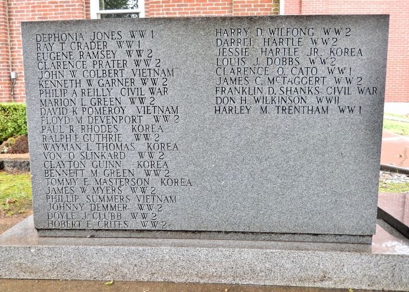
Dephonia Jones WW1 • Ray T. Crader WW1 • Eugene Ramsey WW2 • Clarence Prater WW2 • John W. Colbert Vietnam • Kenneth W. Garner WW2 • Philip A. Reilly Civil War • Marion L. Green WW2 • David K. Pomeroy Vietnam • Floyd M. Devenport . . . — — Map (db m307295) WM
[side 1] Here on a scenic hill at the junction of crystal clear Crooked and Hurricane Creeks, Thomas Hamilton laid out Marble Hill after Bollinger County was organized, March, 1851. First called New California, the town was . . . — — Map (db m179953) HM
A public well 98 feet deep bored here about 1905 improved the area’s health and economy. Citizens of the county seat were all benefited by the medicinal qualities of the water. Visitors also came to stay at one of the town’s hotels and drank the . . . — — Map (db m216752) HM
On this site, Feb 4, 1863, the Union Army rode into the Simeon Cato farm and surprised Daniel McGee troops. 9 were killed outright and 20 more were mortally wounded. The majority of these men are buried in a mass grave at nearby Greenbriar Cemetery. — — Map (db m235178) HM
King Post The king post was the first and simplest truss structure used in America. Its basic design consisted of a center post, the king post, with compression beams slanting downward and outward toward each shore. The original king post . . . — — Map (db m307488) HM
Bollinger Mill
Maj. George Frederick Bollinger built the first mill here in 1800, on a 640-acre grant from Louis Lorimier, Spanish Commandant of Cape Girardeau district of Upper Louisiana. A German Swiss from North Carolina, Bollinger visited . . . — — Map (db m35367) HM
In Missouri, the covered bridge was first used in the 1850s when roads, railroads and overland transportation in general became a practical and important mode of travel. The first covered bridge in the state was built in 1851 in Boone County . . . — — Map (db m307496) HM
1. Corduroy Bridge The corduroy bridge was the earliest of the American bridges and consisted of logs laid across supporting timbers. These were effective for narrow streams, but would have had a short life expectancy. 2. King Post The . . . — — Map (db m307495) HM
Burfordville Covered Bridge is the oldest covered bridge remaining in Missouri. Joseph Lansmon, its builder, began construction in 1858. It is uncertain whether the bridge was completed before or after the Civil War (1861-65). The bridge became . . . — — Map (db m307453) HM
Covered bridges have existed for nearly all of man's recorded history. Ancient Babylonians are credited with having erected the first such structure over the Euphrates River about 783 B.C.. It continued to be a popular bridging method with . . . — — Map (db m307293) HM
Why Restore A Covered Bridge? Quite a few people asked that question when plans were made to start the restoration on Burfordville Covered Bridge. Some of the more important reasons include the following: • Many covered bridges, including . . . — — Map (db m307473) HM
"Red Rover" was the first hospital ship of the United States Navy, the first Navy ship that women served on and the apparent namesake of the popular children's game. It was also build and launched in Cape Girardeau in 1859.
"Red Rover" was a . . . — — Map (db m260707) HM
Burt Bacharach
1928-PRESENT BORN IN KANSAS CITY, MO
This songwriter, record producer, pianist and singer
composed hundreds of hit songs from the late 1950s through the
1980s, including more than 50 top-40 hits and music for the movies
Butch . . . — — Map (db m263278) HM
Between 900 and 1200 A.D., many Native Americans lived in the Mississippi River Valley. Due to their close relationship with the river, anthropologists and archaeologists use the term MISSISSIPPIAN to describe this thriving native culture. This . . . — — Map (db m261425) HM
In 1673 Father Jacques Marquette and Louis Joliet led the first French expedition down the Mississippi. Joliet was the explorer; Marquette was the missionary and chaplain. The French hoped to find a rumored big river to the south that might lead to . . . — — Map (db m107728) HM
In 1673, Jesuit priest and missionary Father Jacques Marquette and French-Canadian explorer and fur trader Louis Joliet led the first French expedition of the Mississippi River. Hearing rumors of a great river to the west that would . . . — — Map (db m263101) HM
Sieur Jean Baptiste Girardot established a trading post in the vicinity of Cape Rock in the middle of the 18th century. This remote outpost became a gathering
place for river travelers. By 1765, maps of the Mississippi River identified the bend in . . . — — Map (db m261431) HM
As part of the French effort to establish a military occupation of the Mississippi River Valley, Ensign Jean Baptiste Girardot established a trading post on the flat plain at the bend of the river north of Cape Rock... known today as the . . . — — Map (db m263103) HM
In 1793 Spanish officials in St. Louis named Louis Lorimier the Commandant of the District of Cape Girardeau. Shortly thereafter, he received Spanish land grants totaling several thousand arpents (1 arpent= .85 acres).In 1806 Lorimier and his . . . — — Map (db m261432) HM
In 1793, Spanish officials in St. Louis named LOUIS LORIMIER the Commandant of the District of Cape Girardeau. Shortly thereafter, the Spanish government sent Lorimier to establish a military post in Cape Girardeau, granting him the rights to . . . — — Map (db m263388) HM
Between 1803 and 1806, Meriwether Lewis and William Clark led President Jefferson's Corps of Discovery to the great American West. On November 23, 1803, they stopped at Cape Girardeau to deliver letters of introduction to Louis Lorimier. Captain . . . — — Map (db m261433) HM
Between 1803 and 1806, MERIWETHER LEWIS and WILLIAM CLARK led President Jefferson's Corp of Discovery to the great American West. During their travels, Lewis and Clark passed through Cape Girardeau on November 23, 1803, delivering letters of . . . — — Map (db m263451) HM
In 1803 the Mississippi River Valley was an important area in international diplomacy and intrigue. Napoleon's brothers, Lucien and Joseph, sought to dissuade him from selling the entire Louisiana Territory to the newly established United States. . . . — — Map (db m261434) HM
French military leader NAPOLEON BONAPARTE was considering selling the Louisiana Territory to the newly-established United States. Napoleon's brothers". Lucien and Joseph visited Napoleon to convince him not to sell the entire territory. Reportedly, . . . — — Map (db m263455) HM
When the territory of Missouri asked for statehood, it sought admission as a slave state since there were already many African-American slaves in the territory. Missouri was granted permission, but would be the only area in the Louisiana Territory . . . — — Map (db m261436) HM
Following the Louisiana Purchase, many people from the south rapidly moved into this area, bringing the institution of slavery with them. In 1818, the territory of Missouri petitioned Congress for statehood as a SLAVE STATE, setting off a NATIONAL . . . — — Map (db m263456) HM
In 1830 the U.S. Congress passed the Indian Removal Act which led to the forced removal of eastern tribes to "Indian Territory" west of the Mississippi (later the state of Oklahoma). In the autumn of 1838, sixteen separate groups of Cherokee, about . . . — — Map (db m261437) HM
In 1830, the U.S. Congress passed the INDIAN REMOVAL ACT, which led to the forced relocation of eastern CHEROKEE tribes to Indian territory west of the Mississippi River. Between 1838 and 1839, the U.S. government forced thousands of Cherokees to . . . — — Map (db m263457) HM
This view of the Mississippi River is from Fort A, one of the four forts constructed by Union forces in the summer of 1861. These forts, which encircled Cape Girardeau, provided protection from attack from either land or water. Fort A was on the . . . — — Map (db m261438) HM
The Civil War left its mark on Cape Girardeau, which is why this mural contains three scenes depicting the conflict.
The mural to the left is the Civil War-era view from FORT A, one of four forts constructed in Cape Girardeau by Union . . . — — Map (db m263458) HM
An exciting incident occurred at the "Battle of Cape Girardeau" on April 23, 1863 when Confederate forces attacked from the west and south of town. During the battle several Confederate cannon balls pierced the roof of the residence of Alfred Lacey . . . — — Map (db m261439) HM
A barrage of cannon fire erupted on Sunday, April 26, 1863 when Confederate forces tried, unsuccessfully, to take the city by attacking from the west and south in the BATTLE OF CAPE GIRARDEAU. During this conflict, several Confederate CANNON . . . — — Map (db m263459) HM
St. Vincent's Young Ladies' Academy was founded in 1839 by the Sisters of Loretto as a school for young women. Located at the corner of Spanish and Good Hope streets, it was one of the first schools for women west of the Mississippi. Prior to its . . . — — Map (db m261441) HM
In 1839, St. Vincent's Young Ladies Academy was founded in Cape Girardeau by
the Sisters of Loretto as a school for young women. It was ONE OF THE FIRST of
its kind west of the Mississippi. Prior to closing in 1923, thousands of young . . . — — Map (db m263460) HM
Before the coming of the railroad, the Mississippi River was the commercial lifeline of Cape Girardeau. The arrival of the packet boats, loaded with goods for local and regional residents, was an exciting event in the community. To the
left of the . . . — — Map (db m261442) HM
Before the arrival of the railroad, the Mississippi River was the COMMERCIAL LIFELINE of Cape Girardeau. The docking of PACKET BOATS, loaded with goods and passengers, was an exciting event in the community. Commonly 60 to 80 feet long and more than . . . — — Map (db m263461) HM
After earlier attempts to build a railroad to Cape Girardeau failed, local attorney Louis Houck made an arrangement with creditors to bring a railroad into the city by midnight of January 1,1881. If he could do so, he would acquire clear title to . . . — — Map (db m261443) HM
After earlier attempts to bring a railroad to Cape Girardeau failed, LOUIS HOUCK, a local lawyer, historian, author and now railroad builder, made an arrangement with creditors based on his ability to build the FIRST RAILROAD LINE from Delta, MO, to . . . — — Map (db m263462) HM
The first sitting President to visit Cape Girardeau was William Howard Taft, who arrived on the riverfront in the early morning of October 26, 1909. He was part of a 16-boat flotilla carrying cabinet members, Congressmen, governors, river . . . — — Map (db m261447) HM
The first sitting president to visit Cape Girardeau
was WILLIAM HOWARD TAFT. He arrived early in the
morning on October 26, 1909. Part of a 16-boat FLOTILLA,
or small fleet, carrying dignitaries, Taft traveled down the
river with cabinet . . . — — Map (db m263389) HM
The city was awakened to the shriek of a steamboat whistle early on the morning of March 15, 1916, to the biggest fire in Cape's history. The blaze began south of Broadway engulfing the Terminal Hotel, the Buckner-Ragsdale Store, the Frisco Railroad . . . — — Map (db m261448) HM
The biggest fire in the history of Cape Girardeau was on MARCH 15, 1916.
The city was wakened by the shriek of a steamboat whistle early that morning.
The blaze began south of Broadway, engulfing the TERMINAL HOTEL, Buckner-Ragsdale
store and . . . — — Map (db m263387) HM
In the early 20th century, the Mississippi
River was WIDER and SLOWER than it is
today. It was more inclined to freeze over
during periods of cold weather. The
WINTER OF 1918-1919 was especially
frigid and the River was covered with ice . . . — — Map (db m263383) HM
In the early 20th century, the Mississippi River was a wider and slower river than today. Because it was slower, it was more inclined to freeze over in periods of cold weather. The winter of 1918-1919 was especially frigid, and the river was covered . . . — — Map (db m261450) HM
For most of the 19th century and the first third of the 20th, steamboats were vital to the economic livelihood of Cape Girardeau and southeast Missouri. Three steamboats bore the name "Cape Girardeau," the last being christened here in 1924. . . . — — Map (db m261451) HM
For most of the 19th century and the first third of the 20th century, STEAMBOATS
were vital to the economic livelihood of Cape Girardeau. Shown here are the three
steamboats that bore the name CAPE GIRARDEAU. The first to carry this name was . . . — — Map (db m263386) HM
Two of the most exciting new trends of the 1920s were jazz and ballroom dancing. The riverboats were ideal locations for both. Here, Jess Stacy on piano and Raymond F. "Peg" Meyer on saxophone, Berg Snider on drums, and Pete Lowry on banjo . . . — — Map (db m261452) HM
Two of the most exciting new trends of the 1920s were JAZZ-and
BALLROOM DANCING. Riverboats were an ideal location for both.
Cape Girardeau's "music man" RAYMOND F. "PEG" MEYER led one of the most
: popular bands that played on the riverboats. . . . — — Map (db m263384) HM
The great flood of 1927 remains the flood by which all Mississippi River floods are measured. The devastating effect upon the lower Mississippi River resulted in the Jadwin Plan, which sought to control the river with a coordinated system of levees . . . — — Map (db m261454) HM
The GREAT FLOOD OF 1927 remains the flood by which all
Mississippi River floods are measured. At that time, it was the most
destructive flood in American history and the nation's largest natural disaster. It caused
more than $1 BILLION IN . . . — — Map (db m263381) HM
The Mississippi River provides an abundant supply of sand to Cape Girardeau. This great resource has enhanced the community's ability to construct such large concrete projects as the A.C. Brase Arena Building, the Common Pleas Courthouse steps, . . . — — Map (db m261455) HM
The Mississippi River provides an abundant
supply of sand to Cape Girardeau. Used to make
concrete, this great resource enhanced the
community's ability to construct large concrete
projects such as the A.C. Brase Arena, Interstate . . . — — Map (db m263286) HM
After centuries of floods, the Mississippi River flood-wall provided protection from the floodwaters that periodically ravaged Cape Girardeau. Construction began on the massive flood-control project in 1956 and was completed in 1964 at the cost . . . — — Map (db m261456) HM
After centuries of floods, construction on the Mississippi River FLOODWALL
began in 1956 to protect the city from the waters that periodically ravaged
the town. The massive flood-control project was completed eight years later in
1964 at a . . . — — Map (db m263380) HM
Cape Girardeau has a close relationship with the Mississippi River. For 21 years Riverfest celebrated the fact that the community was on the river and of the river. The festival featured music, games, food, fireworks, crafts, and special events. . . . — — Map (db m261457) HM
The initial effort to develop TOURISM
into an economic force began in 1978.
There were very limited funds available to
promote the city. From that need the idea of a river
festival to raise money arose. For 21 YEARS,
from 1978 to 1999, the . . . — — Map (db m263379) HM
After 15 years of planning and 7 years of construction, the Bill Emerson Memorial Bridge opened to traffic on December 13, 2003. The bridge was named for Bill Emerson, an eight-term Congressman who had championed the legislation that brought about . . . — — Map (db m261429) HM
After 15 years of planning and seven years of construction, the Bill Emerson
Memorial Bridge opened to traffic on December 13, 2003. The Bridge was named
for BILL EMERSON, an eight-term congressman who had championed legislation
that brought . . . — — Map (db m263293) HM
Reportedly Fort D was armed with three 32-pounder smoothbore cannon, Model 1829, and two 24-pounders, Model 1819. A 32-pounder can fire a solid round shot weighing 32 pounds for nearly a mile. Such a shot required a load of 8 pounds of gunpowder. . . . — — Map (db m236818) HM
Marie Watkins Oliver
1854 - 1944
Lived in Cape Girardeau, MO
Called the "Betsy Ross of Missouri," this individual designed
the Missouri State Flag, following extensive research, vision
and perseverance. In 1904, Oliver joined the . . . — — Map (db m263288) HM
The Mississippi River Tales Mural is the largest and most dramatic of
Cape Girardeau's murals. The 1,100-FOOT-LONG mural contains 24 PANELS,
measuring 15 feet high and covering nearly 18,000 SQUARE FEET of the
downtown floodwall.
For . . . — — Map (db m263291) HM
This building was constructed in 1937 by the Hecht family, the Jewish Community and local support from business and individuals alike. This synagogue served all of southeast Missouri’s Jewish citizens. With its Islamic influences, ceramic glazed . . . — — Map (db m235999) HM
Rarely being on alert and never under attack, boredom and disease were the biggest enemies of the soldiers serving at Fort D. Soldiers passed their spare time reading, writing letters, playing cards, sewing, gambling, or playing music. Games played . . . — — Map (db m236820) HM
Jack
Buck
1924-2002 LIVED IN ST. LOUIS, MO
Born John F. Buck, this sportscaster is best known for
his play-by-play work announcing St. Louis Cardinals'
Major League Baseball games on KMOX radio for
nearly 50 years and his trademark phrase . . . — — Map (db m263111) HM
Cape Girardeau's recreational center was named in honor of the Capaha Indians whose fortified village occupied a high spot north of the big swamp just south of the city. This spot was undoubtedly familiar ground to the Capahas.
Desoto's . . . — — Map (db m307165) HM
[side 1] Founded as an Indian trading post, 1793, by French Canadian Louis Lorimier. Probably named for Girardot, a trader at Cape Rock. In 1795 Lorimier became commandant of Cape Girardeau District, most American of the 5 . . . — — Map (db m179995) HM
After the golden age of the steamboat, port cities like Cape Girardeau suffered as railroads provided alternate means of transportation.
Responding to the post-Civil War railroad boom, a syndicated of local business leaders formed the Cape . . . — — Map (db m260708) HM
[northwest side]Maj. Gen. John V. Cox Vice Adm. Arthur L. Willard [southwest side]Gen. Seth J. McKee Cpt. Stephen W. Thompson Gen. Roscoe Robinson Jr. [south side]PFC. Richard G. Wilson Congressional Medal of . . . — — Map (db m179990) HM WM
In the 1790s, the Spanish governor granted Louis Lorimier permission to operate a ferry service at Cape Girardeau.
Thereafter, ferry operators continued to shuttle people and products across the Mississippi River until 1928 when a new, privately . . . — — Map (db m260709) HM
In 1699, fathers Montigny, Davion, and St. Cosme, French missionaries erected a cross where this stream entered the Mississippi and prayed that this might be the beginning of Christianity among the Indians.
The stream has ever since been known as . . . — — Map (db m58683) HM
August Busch (1899-1989) was born in St. Louis, MO.
He headed what has become the world’s largest brewery, Anheuser-Busch. In 1953, he purchased the St. Louis Cardinals baseball team and inspired them to compete in six World Series from . . . — — Map (db m261458) HM
August Anheuser
Busch Jr.
1899-1989 NATIVE OF ST LOUIS, MO
Described as a showman and salesman and called Gussie, this
brewing magnate built St. Louis-based Anheuser-Busch into the
largest brewery in the world by 1957 as its company . . . — — Map (db m263279) HM
This stately Beech is one of the largest and oldest trees in the State of Missouri. A registered "champion" tree, it is approximately 200 years old. Quite possibly it was alive at the time of the Louisiana Purchase in 1803.
The American Beech . . . — — Map (db m261459) HM
Work on Fort D began on August 6, 1861 under the direction of Lieutenant John W. Powell of Illinois. Later, Powell recruited a company of loyal Cape Girardeau men to serve in the Union army. Since Powell was from Illinois, these men were mustered . . . — — Map (db m236816) HM
Deep-water ships cannot sail the Mississippi River. The river is
frequently too shallow, and its strong currents would play havoc
with ships designed to navigate oceans. At its headwaters, the
Mississippi is less than three feet deep. Nor . . . — — Map (db m261460) HM
Josephine Baker (1906-1975) was born in St. Louis, MO. Her creative, exotic acts made her a singing star from New York to Paris. During WWII, she worked with the Red Cross, gathering intelligence and entertaining troops in Africa and the . . . — — Map (db m261461) HM
Built in the mid-1800s, this is one of the oldest buildings still standing on what was once known as “Warehouse Row.” With easy access to the Mississippi River steamboats & the railroad, the businesses located here made major contributions to the . . . — — Map (db m236099) HM
“Fort D,” one of the four forts erected in Cape Girardeau by Union forces in 1861, is the only one preserved. Its site southeast of the town was chosen to command the entire bend of the river southward, and also the river road from downstream. . . . — — Map (db m236773) HM
Fifty Years of Achievement This tablet is dedicated to George and Fred Naeter founders and publishers of the Southeast Missourian as a grateful tribute to their tireless, unselfish and devoted efforts to make ours a better and . . . — — Map (db m236199) HM
George Drouillard was chief hunter and interpreter on the Lewis and Clark Expedition Corps of Discovery. He was the son of a Frenchman and Shawnee woman as well as nephew of Louis Lorimier, Commandant of the Cape Girardeau District. Drouillard lived . . . — — Map (db m51818) HM
George Washington Carver (1864-1943) was born in Diamond Grove, MO. As an agricultural chemist and inventor at Tuskegee Institute, now Tuskegee University, in Alabama, he developed a system of crop rotation. He also discovered 300 uses for . . . — — Map (db m261463) HM
Southeast Missouri was where Ulysses S. Grant, the nation's eighteenth president, began his rise to prominence as a soldier. This story began in mid-August, 1861, at Ironton, Missouri, 70 miles west of Cape Girardeau via Missouri Highway 72. Grant . . . — — Map (db m261479) HM
In April 1861, Ulysses Simpson Grant, a graduate of West Point and a former army officer, was out of the army and clerking in his father's store in Galena, IL. Grant's loyalties were clear: "We have a government and laws and a flag, and they . . . — — Map (db m236791) HM
The H&H building was built in 1908 by J.H. Himmelberger & W.H. Harrison, two of Cape Girardeau's most prominent businessmen. It was the first steel reinforced structure built in Cape Girardeau and has served as a commercial center for the business . . . — — Map (db m236185) HM
Ginger Rogers (1911-1958) was born in Independence, MO. Nicknamed Feathers, she was a dancer extraordinaire and attained real stardom paired with Fred Astaire. She got her start in vaudeville at the age 14, and her first big movie hit was 42nd . . . — — Map (db m261465) HM
Harry S.
Truman
1884-1972 | BORN IN LAMAR, MO
This statesman grew up in Independence, MO,
and later became the 33rd President of the United
States. A WWI veteran, Truman served as an Army
Captain in France. After his wartime service,
Truman . . . — — Map (db m263276) HM
In 1911, Cape Girardeau members of the Missouri Chapter of the Woman's Relief Corps, an auxiliary to the Grand Army of the Republic, commissioned a memorial to the fallen soldiers of the City and County. Dedicated on May 30, 1911, the memorial . . . — — Map (db m236269) HM
When Cape Girardeau was originally platted in 1806, a square was dedicated to public, common use. Court was held in a simple, wooden structure on Themis St. several blocks west of the riverfront. Under English law, violations against government . . . — — Map (db m236285) HM
In Memoriam
These sons of Cape Girardeau County made the supreme sacrifice in the Korean Conflict
Buddy Joe Bonney • William Brockmire • Donald E. Franklin • Bobbie Foster • Jean L. Giroir, Jr. • Arthur W. Helderman • John L. Hunter . . . — — Map (db m307385) WM
Redd Foxx
1922-1991 BORN IN ST LOUIS, MO
Born John Elroy Sanford, this entertainer is best remembered
for his explicit comedy records and his starring role on the 1970's sitcom
Sanford and Son. Ranked in the top 25 best stand-up comedians, . . . — — Map (db m263277) HM
Kate Chopin
1850-1904
Native of St. Louis, MO
Born Kate O'Flaherty, this author of short stories and novels is widely recognized as one of the leading writers of her time. Best known for her feminist novel The Awakening, Chopin's . . . — — Map (db m263107) HM
Laura Ingalls Wilder (1867-1957)
was born in Lund, WI. In 1894
she moved to Mansfield, MO.
where in the 1930s and 1940s
she published her best selling
Little House books chronicling
her pioneer life. These books
later became the basis for . . . — — Map (db m261478) HM
Manitowoc Shipbuilding Company
One of the most unusual WWI Mississippi River transportation stories concerns the Manitowoc [Wisconsin] Shipbuilding Co., the nation's only inland builder of submarines.
In December 1940, the U.S. Navy contracted . . . — — Map (db m261468) HM
At the beginning of the Civil War, President Abraham Lincoln requested states raise 75,000 volunteers for troops. In response, the 1st Nebraska Volunteer Infantry Regiment was organized during the early summer of 1862, partially, in order to . . . — — Map (db m236817) HM
Samuel Clemens (1835- 1910), who wrote under the pseudonym Mark Twain, was born in Florida, MO. His stories about Tom Sawyer, Huck Finn and friends reflected his love for his boyhood hometown of Hannibal, MO. Unconventional in both his life and in . . . — — Map (db m261469) HM
1928 — The former Marquette Hotel was completed around the time the first bridge opened linking Cape Girardeau to Illinois. The bridge boosted Cape Girardeau's economy and became a popular place for traveling business men and families to stop . . . — — Map (db m236200) HM
George Caleb
Bingham
1811-1879 LIVED IN ST LOUIS, MO
Considered one of the greatest American painters of
the 19th century, his work features life in the frontier
lands along the Missouri River. Born in Virginia,
Bingham later moved to St. . . . — — Map (db m263113) HM
Without the floodwall and pump stations, Cape Girardeau's historic downtown area would not stay dry during flooding. The entire flood protection system is critical in keeping the district dry and safe. The combination of earthen levees and . . . — — Map (db m236283) HM
Missouri Mule The mule was adopted as Missouri's state animal in 1995. Generally considered smarter, hardier, and more sure-footed than a horse, mules have been used or pulling wagons and other endurance-related task. For many years Missouri . . . — — Map (db m261470) HM
433 entries matched your criteria. The first 100 are listed above. Next 100 ⊳