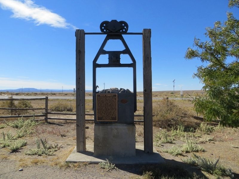
Rock asphalt was first mined at the top of Whitmore Canyon - 15 mi. NE of this location - in the early 1890's. The mine closed in 1898 & re-opened in 1903. It operated erratically until 1915 when it was forced to close due to the development of . . . — — Map (db m148003) HM
Early settlers in Whitmore Canyon, later called Sunnyside, were Jefferson Tidwell, his family and a brother John, who grazed cattle in the area prior to building their home in 1897. They located a vein of coal, sold it to the Utah Fuel Company for . . . — — Map (db m148001) HM
This one-story red brick commercial building was built in 1927 by Helper Securities.
Five business storefronts completed the whole of this larger building. The northernmost portion at 167 South Main Street was occupied by the Success Meat and . . . — — Map (db m148211) HM
This single-story, red brick, commercial one-part block building was originally owned by John Milon, George Gigoumakis, and Steve Zoulakis. The building was at one time an O.P. Skaggs meat and grocery store operated by Barney Hyde. Mr. Hyde was also . . . — — Map (db m148217) HM
Erected in 1918, by inmates of The Utah State Penitentiary. This monument honors Simon Bamberger, Governor of Utah from 1917 through 1920. Under a state law passed in 1911 permitting prisoners to work on State roads, the prisoners participated in . . . — — Map (db m148288) HM
This caboose was built in 1918 by the Mt. Vernon Car Company for the Utah Railway Company. It was refurbished in 1958 at which time the steel siding was added. Caboose N°. 55 traveled the route from Provo to Mohrland from 1918 to 1975. That's 57 . . . — — Map (db m279226) HM
The mine was opened in 1916 by George Diamanti as Hardscrabble Coal Company which was operated by Utah Fuel. By 1963 after numerous name and ownership changes, the mine was owned and operated as Carbon Fuel Company.
On December 16, 1963 at . . . — — Map (db m265333) HM
The Carbon Hotel was built in the early 1900's. It was first owned by C.A. Bartolino. The building was used as a hotel, bar, cafe and sporting house throughout the years. Due to the large number of single male immigrants into the local mines, the . . . — — Map (db m100991) HM
This monument is dedicated to the Carbon Plant, located SE of this site, the fourth coal-fired facility built by Utah Power. Construction on the $26 million plant began the summer of 1953, in cooperation with the International Brotherhood of . . . — — Map (db m148289) HM
At 8:30 a.m., March 8, 1924, an explosion occurred in the Castle Gate No. 2 Mine, located about one half mile to the southeast of this site, instantly killing 171 miners. Rescue teams were rushed to Castle Gate from the surrounding mines. Wearing . . . — — Map (db m148291) HM
This two-story, stucco, commercial building was constructed in 1922 and originally owned by Charles A. Bertolino. The main level interior was divided to allow for two separate businesses. The north side housed the Athens Restaurant, which was . . . — — Map (db m279227) HM
In 1885 Alfred Grames took up residence at Oak Springs Bench at the head of Gordon Creek, which was later to become Coal City.
In August of 1921 George Storres filed a petition to establish a townsite and to develop coal properties. The town . . . — — Map (db m291465) HM
When coal mining started in the Bookcliffs and Wasatch Plateau back in the late 1800s, many miners from different ethnic groups from America and countries from around the world came to Carbon County to mine the coal to provide for their families, . . . — — Map (db m279052) HM
The continuous miner cuts and conveys coal from the mine to a waiting shuttlecar that is parked underneath the miners all section. When eight tons of coal have been loaded onto the shuttlecar, the operator changes seats and drives the shuttlecar to . . . — — Map (db m279049) HM
The coal was dynamited at the face of the mine. A waiting loader was used to gather and scoop coal from the mine floor onto it's conveyor, then filling at
shuttlecar. The shuttlecar transported the coal to one of fourteen five-tone coal cars, on . . . — — Map (db m279057) HM
Utah Railway was created in 1912 to provide improved service to the coal mines of western Carbon and Emery counties. Tracks from Hiawatha to the Utah Railway junction near Martin were completed in Oct. 1914. A steel girder bridge 135 ft. high, 634 . . . — — Map (db m148206) HM
In the early years of World War II, the United States Government determined that it was necessary to locate strategic defense industries in locations that would not be subject to immediate attack in the event the Japanese invaded the West Coast of . . . — — Map (db m279065) HM
Heiner was located on the mountain at the mouth of Panther Canyon
and on the main line of the D & RG Western Railroad, approximately
halfway between Helper and Castle Gate at an elevation of 6,023 feet.
In 1911, Frank Cameron, a prominent . . . — — Map (db m291472) HM
This valley was originally settled in 1881 by Teancum Pratt. The original Pratt Survey still predominates on maps of this area. He sold land to the Rio Grande Western Railroad for a right of way. By the fall of 1887 the railroad had built 27 frame . . . — — Map (db m148214) HM
This one-story red brick flat roof building was built as the Helper City Hall in 1927. This building has classical "tin" cornices, columns and pediment. The project architect was Walter E. Ware of Salt Lake City.
The City Hall has been a center . . . — — Map (db m148212) HM
Built in 1937, the Helper Civic Auditorium was designed by Salt Lake City architects Carl W. Scott and George W. Welch. The building is an excellent example of Art Moderne style also known as "Streamline Moderne." The style was popular in the 1930s . . . — — Map (db m148221) HM
This hotel was built in 1913-14 for the Helper Real Estate and Investment Co. Formed by people of many different ethnic groups, including Assyrian, Italian, and Jewish, this company reflected the diverse nature of Helper's population. A favorite of . . . — — Map (db m148122) HM
The Helper Main Post Office, built in 1937 by the Works Progress Administration (WPA), is significant for its association with the federal government's New Deal public arts programs. As one of only three Utah post offices that contain public art, it . . . — — Map (db m148220) HM
The mining town of Helper has been the backdrop to independent films and television shows over the years looking to capture the small town feel of the historic and restored downtown. The Book Cliffs mountain range offset by the railroad that passes . . . — — Map (db m279228) HM
This one-story red brick commercial block was built by Helper Securities in 1927 and contained seven businesses. The northern section originally housed the J.C. Penney store managed by M.P. Street. Just south, the Safeway store was operated during . . . — — Map (db m278789) HM
In 1973 local Girl Scout Cadette Troop 555, consisting of 39 girls ages 12-15, envisioned a place for Helper Senior Citizens to rest and enjoy their day.
The girls noticed a vacant lot on Main Street that was an eyesore littered with old cars . . . — — Map (db m278769) HM
Helper was first settled in 1881 by Teancum Pratt and his plural wives. He then settled into what he described as "a lonely wilderness" where he sought to escape the "hunters, trappers and bachelors and raveheads in the area of his previous farm . . . — — Map (db m278785) HM
From Past
Settled in 1881, immigrants came from all over the world in search of a better life working in the mines or on the railroads, creating a cultural tapestry unlike any other in Utah. By the 1920s, at least 27 languages could be heard . . . — — Map (db m279067) HM
Historic Helper Main Street
Helper Main Street these were some of the
first wooden buildings on Helper Main Street. They
were either replaced or burned in the fire of 1919.
All of the other buildings mentioned in this . . . — — Map (db m279069) HM
Once the coal was blasted, pit cars or mine cars were loaded using the Joy loader. The loading machine replaced hand loading (the shovel). This machine was last used at Carbon Fuel Co Number 3 mine near Helper Utah. — — Map (db m279054) HM
Latuda saw its first residents in 1914 when prospectors found coal in the area. The Liberty Fuel Mine opened in 1917 when Frank Latuda and Charles Picco bought the property and moved the portal closer to the canyon floor. Twenty homes were built . . . — — Map (db m265662) HM
Matt Warner was born Willard E. Christiansen in Ephraim, Utah. He left home at the age of 14 after a fight in which he thought he killed the town bully. He took the name Matt Warner, became a cattle rustler, bank robber and rode with Butch Cassidy . . . — — Map (db m101029) HM
Peerless
Peerless, just 3 miles west of Helper, was the first mine developed in the Spring Canyon District. The property was purchased in 1916 by brothers William and Charles Sweet. They developed the coal operation including a gravity . . . — — Map (db m265875) HM
Near this site stood the Pleasant Valley Coal Company office and store.
On April 21, 1897, in of of the most daring daylight robberies, Butch Cassidy, Elsa Lay, and Bob Meeks robbed paymaster E.L. Carpenter and made off with over $8000.00 in . . . — — Map (db m148293) HM
Pleasant Valley Junction about 1/2 mile So. of this site, began in the early 1880's when the Rio Grande R.R. extended the main line from Tucker over the summit into Carbon County. A round house was built and a branch line extended to the Pleasant . . . — — Map (db m148616) HM
The Rainbow Inn is located at 305 N Mains St, Helper, Utah and was built in 1922. Originally owned by Lena Fodero, the building was used as a hotel, bar, and sporting house. It was known for the bordello on the upper floor. The railroad which . . . — — Map (db m106558) HM
The area around the rock formation known as Castle Gate was originally settled as Bear Canyon.
In 1913 Frank Cameron opened a small mine operation and the town was renamed Cameron.
In 1917 Cameron sold the mine to Henry Rolapp and the . . . — — Map (db m265335) HM
This two-story brick commercial building was constructed in 1929. The varied shades of tan bricks are unusual in the historic district. In the early 1930s, the right side of the building was occupied by the "Smart Shop" owned by N.A. Neilson, and . . . — — Map (db m148208) HM
The town of Spring Canyon, or Storrs as it was
originally called, was the site of the first coal mine
in Spring Canyon. A small mine was worked in
Sowbelly Gulch by Teancum Pratt beginning
about 1895, then in 1912 "Uncle" Jesse . . . — — Map (db m291471) HM
The Catholic Mission Church was built at Castle Gate, Utah in 1898. It burned down in 1907. Catholics then worshipped in Helper at the Railroad Non-Denominational Chapel which was erected by the railroad in 1899.
On this location in 1914 the . . . — — Map (db m291488) HM
Frederic Sweet founded the town of Standardville in 1911. For 4 years everyone lived in tents. By 1914 railroad sidings were in place and 200 tons of coal a day were mined.
By 1917 the town had become a well planned community setting the . . . — — Map (db m291473) HM
This gazebo was constructed during WW1 in the coal-mining town of Standardville, Utah near the company store. This was an era when most small towns had their own bands and other forms of local entertainment. The bandstand, as it was affectionately . . . — — Map (db m278786) HM
Attached to "jackpipes" (vertical posts anchored between the mine roof & floor), the shortwall was used to undercut the coal prior to blasting. This machine was last used in the O'Connor Mine near Clear Creek, Utah. — — Map (db m279063) HM
Sweets Coal Company
In 1928 Will Sweet discovered coal in a small canyon northeast of National. Sweets was the smallest of the mines in the Gordon Creek area. It was a tent city for almost 10 years with a population of close to 200 people. . . . — — Map (db m291467) HM
The Barboglio Building was built in 1907 by Joe Barboglio. The building housed the Tika Tavern with a hotel upstairs. Mrs. Barboglio ran the hotel and washed the linen by hand in the Price River. In 1910, in an effort to help other businessmen, the . . . — — Map (db m148209) HM
(1) Coal must be broken away from the face of the coal seam.
1. In the early mines picks were used to break the coal away from the face.
2. Then holes were drilled in the face and dynamite was tamped into the hole and detonated (1900-1950).
3. . . . — — Map (db m278801) HM
Big John was an original idea, born from the creativity and enthusiasm of Helper citizens, the Mayor and the City Council. In February of 1964, many of the movers and shakers of Helper decided the city needed a civic attraction. On February 27, . . . — — Map (db m277796) HM
This track mounted shovel called a mucking machine was to the hard rock mines as the 'Joy loader" was to the coal mines. When the rock face was blasted "the mucker", operated by air, was used to load the loose blasted rock (muck) into mine cars. . . . — — Map (db m279062) HM
Around 1891 after the D & R G W Railroad replaced the narrow gauge, with standard gauge track, the division point was consolidated in Helper. At this time a 15 stall roundhouse, a new depot and other accommodations were built. In 1919 the division . . . — — Map (db m148207) HM
The name Carbon County appropriately suggests the importance of carbon products to the economy and history of this area.
The first commercial development of coal occurred in this vicinity in the 1870's and soon out distanced production in other . . . — — Map (db m148292) HM
Western Springs Canyon
Mutual and Rains were not the only mines in the extreme western end of Spring Canyon. There was the Little Standard mine (1925-1945) operated by the Standard Coal Company and three small family operated mines, the Day, . . . — — Map (db m265879) HM
On July 31, 2000, at approximately 11:48 p.m. an explosion and fire rocked the Willow Creek Mine taking the lives of Shane Stansfield and Cory Jordon Nielson and sending 8 other miners to the hospital. The explosion marked the end of a short and . . . — — Map (db m148290) HM
Due to Utah's high unemployment rate during the Depression (63% in 1933), federal recovery programs were extensive in the state. Virtually every public building constructed in Carbon County during the 30's was built by one of these agencies. . . . — — Map (db m265342) HM
Coal was discovered in Price Canyon near Castle Gate in 1888, and the Pleasant Valley Coal Co. immediately opened the Castle Gate No. 1 Mine. The Wasatch Store was built in 1890 and served the camps of Castle Gate and Willow Creek as the "Company . . . — — Map (db m265665) HM
Coal was discovered in the Kenilworth area by Heber Stowell in 1886. Western Coal & Coke Company began mining and by the end of that year Independent Coal & Coke Company incorporated and took over operations. Construction on the townsite began in . . . — — Map (db m265631) HM
Vincent Paul Anella Troop 296
Eagle Scout Project
Reestablished marker recognizing the first cabin built in Price by Abraham Powell in 1877. Original marker was at 600 South Carbon Avenue.
December 22, 2011
Price Centennial . . . — — Map (db m72728) HM
Organized and built by the Greek immigrants of Carbon County. Dedication August 15, 1916 by Reverend Mark E. Petrakis. Built in traditional byzantine style. — — Map (db m148008) HM
When coal mining started in the Bookcliff and Wasatch Plateau back in the late 1800's many miners from different ethnic groups from America and countries
from around the world came to Carbon County to mine the coal to provide for their families, . . . — — Map (db m279581) HM
In memory of Carbon County boys who gave their services and lives in the World War, 1917-1918
Stevenson, George West ·
Thomas, Guy Irving ·
Albo, Vincenzo ·
Anderson, Edward C. ·
Baker, Burl H. ·
Crawford, Abraham J. ·
Curtis, . . . — — Map (db m279572) WM
On this site was located the Carbon Tabernacle, a landmark and center place of worship from 1914 to 1961 for members of the Church of Jesus Christ of Latter-day Saints.
For 47 years the Tabernacle served as the Carbon and North Carbon Stake . . . — — Map (db m148112) HM
The settlement of Price began in 1877 when Caleb B. Rhodes and Abraham Powell arrived here. Two years later a number of Later Day Saints and their families strengthened the settlement. A branch of the church was organized in 1881 and in 1882 George . . . — — Map (db m148009) HM
This GE Steam Turbine was built in Schenectady, NY and was commissioned
in 1976 for Unit 2 of the Huntington Plant and it was in service until 1998.
During that time, this turbine was used to produce 3.6 million megawatt hours
of electricity. It . . . — — Map (db m279583) HM
The Albert Grames cabin, built in 1891, stood originally on a site two miles northwest of here. In 1904 Grames bought land in Price, dismantled his cabin, and used the logs to build this somewhat larger structure. The cabin is unique in that it was . . . — — Map (db m148119) HM
Harding School was named after President Warren G. Harding. Classes started August
1925 with George Fox as the first principal.
It was used as an elementary school until May 1968 when Principal James L. Jensen
called classes to order for the . . . — — Map (db m101032) HM
In memory of those who made the supreme sacrifice
World War I
Henry Holdsworth
Sheldon Adolph Axelson
William Harmon Walkington
William Henry Mather
Abe Crawford
World War II
Joseph Kolovich
LeRoy O. Davis
Anthony . . . — — Map (db m279579) WM
This house was built in 1911 for James W. and Mary K. Loofbourow. Reportedly the “costliest residence in eastern Utah” at the time of its construction, it is one of the very few large, elaborate houses built in Price during the early twentieth . . . — — Map (db m253306) HM
Matt Warner left home in 1879 at age 15, thinking he had killed a rival in a fight over a girl. He lived his early life on the outlaw trail as a bandit & rustler & was sent to prison on Sept. 21, 1896. Matt was pardoned by Governor Wells on Jan. . . . — — Map (db m265633) HM
Construction on the Notre Dame de Lourdes Catholic Church began in May, 1919. The building was completed and dedicated June 20, 1923. The basement was used for services during the four years of construction. The church was build under the direction . . . — — Map (db m148117) HM
This cabin, believed to be the oldest on Price Townsite, was built by Leander Clifford in 1884. The Daughters of the Utah Pioneers purchased the home in 1928 and moved it to the Price Tabernacle site where it was used as an historical relics hall. . . . — — Map (db m148121) HM
The peace garden is dedicated to all the veterans of the Uited States Armed Forces who have served with honor, heroism, love and devotion that all may have the opportunity to live in peace and freedom.
American Legion Price Post No. 3. . . . — — Map (db m279580) WM
We hold in sacred memory those sturdy and brave pioneer women, who left their homes in the Eastern United States or sailed from the foreign lands; that trekked across hills, plains, and mountains, forded streams and rivers, birthed and buried loved . . . — — Map (db m148118) HM
The Municipal Building was constructed 1938-1939. The construction was funded with $85,000 provided by the city and a $90,000 federal grant from the Works Progress Association. The building is significant as one of the largest buildings constructed . . . — — Map (db m148111) HM
The Star Theatre was built in 1923-24 for the five Georgedes brothers: Pete, Angelo, Charlie, George and Harry. Natives of the Greek island of Mytelene, the Georgedes brothers immigrated to the United States and by the early 1920's had become . . . — — Map (db m148116) HM
The road through Nine Mile Canyon was constructed in 1886 by the Buffalo Soldiers of the U.S. 9th Cavalry to connect Fort Duchesne to the railroad in Carbon County. Most of the stagecoaches, mail and freight passed through Nine Mile into the . . . — — Map (db m72729) HM
We honor the memory of the brave men and women who served our country in time of need. American Legion Price Post #3 Veterans of Foreign Wars Miners Post #2379 Price Marine Corp League Det. #1 Price Lions Club — — Map (db m303387) WM
This cabin, believed to be one of the oldest in Castle Valley, was built on Gordon Creek by Albert Grames in the early 1880s. It was moved to Price in the year 1900 and used as a Grames family residence until 1964. Albert Grames, in addition to . . . — — Map (db m265634) HM
In 1919 the Denver and Rio Grande Western Railroad decided to move their operations from Helper to Soldier Summit to cut their operating costs. This proved to be a horrible idea. The first housing provided by the railroad was nothing more than thin . . . — — Map (db m124086) HM
This monument pays tribute to Frances Marion Ewell and the sturdy pioneers who settled here.
Mr. Ewell was born November 3, 1935, the son of William Fletcher and Mary Bland Ewell. William was a member of the famous Mormon Battalion which helped . . . — — Map (db m148294) HM
1/18/1996 9/19/2008 A natural born athlete Sports were his passion wrestling was his game, since age 3 17 times State Champion 32 Times National Champion 2 times Jr. High Champion 42 times All American Finishes Caleb was loved by . . . — — Map (db m267689) HM
In 1877, President Brigham Young called on Jefferson Tidwell to explore the country east of the Wasatch Range: which is now Carbon, Emery, and Wayne Counties. President Brigham Young, told him that if he would settle on White River, now Price River, . . . — — Map (db m148006) HM
In 1877 Jefferson Tidwell was called by Brigham Young to find a location for settlement east of the Wasatch Mountains. By 1879 the first pioneers came, built homes, later irrigated their farms with Price River water. This log cabin, built by Robert . . . — — Map (db m148004) HM
Responding to a call from Brigham Young, Orange Seeley organized groups in Sanpete County to settle Castle Valley. Sheep and cattle men had been here earlier. In 1879 the first settlers located in Castle Dale building their first dugouts under a . . . — — Map (db m147917) HM
In 1884 Henry H. Oviatt, Sr. and Samuel N. Alger with their families homesteaded here. When others came, they built a 15 mile irrigation canal, surveying by spirit level and using hand tools. Cleveland Canal & Agricultural Co. organized 1889, to . . . — — Map (db m147925) HM
1981 In Memory Of
Charles William “Bill” Winder and Caroline Elizabeth Mills
William was the 1st boy born in Desert Lake, Utah, June 28, 1888, to Charles Henry Winder & Helen Pilling. Grandparents: Thomas Harrison Winder & . . . — — Map (db m147926) HM
In 1908 the townsite of Elmo was laid out. Each summer a bowery was erected east of
this site where social events were held. In 1911 a group of men purchased the Cleveland
schoolhouse, dragged it with teams and logs to the bowery lot. It was . . . — — Map (db m147941) HM
Before 1890 Thomas E. Davis filed on land in this vicinity. Others followed, erected homes, a schoolhouse and meeting place. June 16, 1912, a branch of The Church of Jesus Christ of Latter-day Saints was organized, George H. Oviatt presiding elder. . . . — — Map (db m147940) HM
When the Mormons fled to Utah in 1847, they were looking for a place nobody else wanted. From Salt Lake City, Brigham Young “called” them to colonize towns and cities all over the great West. The last call came August 22, 1877, when . . . — — Map (db m147829) HM
In the 1870s, the Mormon Settlers came east across the Wasatch Plateau to the high mountain deserts of Castle Valley and the San Rafael Swell. It was the last place Mormon colonizer Brigham Young called his people to settle. They were seeking new . . . — — Map (db m147828) HM
The Emery LDS Church, built 1898-1900, is the oldest remaining religious building in Emery County. The construction technique, a wood frame sheathed with clapboard and lined with adobe bricks, is distinctive and unusual for turn-of-the-century . . . — — Map (db m147830) HM
This is outlaw country! Hidden deep in these canyons, Butch Cassidy, Elza Lay, Flat Nose George, Kid Curry, Joe Walker, and others eluded the lawmen who pursued them in the late 1800s. In the 1850s Chief Wakara escaped into these badlands with as . . . — — Map (db m80465) HM
From 1885 to 1889, the pioneers who located on the Muddy three miles north east from the town of Emery, built in their poverty a tunnel 1200 feet long through blue slate rock to bring water to the town. Their only tools were pick and shovel and . . . — — Map (db m147840) HM
The Presbyterian church entered Utah Territory and expanded rapidly between 1869 and 1883. Around 1911, they erected this building as the Ferron Wasatch Academy, one of forty such institutions in Utah.
These private educational systems led to the . . . — — Map (db m147843) HM
The first permanent settlers of Ferron arrived Dec. 6,1877. They were Swen Larsen and son Niels Christian Larsen, Nicholas Larsen and wife Helena, Peter F. Peterson and wife, Caroline. The first woman with a family of children, Ann Singleton . . . — — Map (db m147842) HM
You’ll soon enter the city of Green River, a century-old crossing, where early explorers, train passengers, and other travelers stopped for a meal and a night’s rest before moving on. In the past, there was J.T. Farrer’s Ferry and the railroad . . . — — Map (db m282586) HM
At this location in January of 1854, the Great Pathfinder of the American West, John C. Fremont, and 21 other men found themselves in the middle of winter. The explorers were part of Fremont's last expedition of the American west.
Having left . . . — — Map (db m134347) HM
The first organized attempt to conquer the swirling rapids and precipitous walled canyons of the Green and Colorado Rivers was made by Major John Wesley Powell, Civil War hero and explorer.
Warned by Indians and mountaineers they would never . . . — — Map (db m102089) HM
They call it the San Rafael Reef, a 30-mile-long stone barrier, a sawtooth ridge at the eastern edge of nowhere. For centuries, only the most intrepid travelers found their way through its narrow slot canyons and on to the Green River crossing. The . . . — — Map (db m282588) HM
You are entering a spectacular but wild landscape, the San Rafael Swell. A
massive, eroded anticline, the San Rafael Swell is 75 miles long and 30
miles wide. Its sandstone reefs, buttes, pinnacles, canyons, and cliffs are stunning, if
a bit . . . — — Map (db m279585) HM
Henry Mountains Isolated, rugged and remote, the Henry Mountains became the last mountain range to be surveyed in the lower 48 states. In 1872 on John Wesley Powell's second expedition to the area, Powell's bother-in-law, Almon H. Thompson, . . . — — Map (db m141736) HM
Desert Lake, about 8 miles east of here, was first settled in 1885 by settlers building an irrigation ditch from Huntington Creek to the townsite and a reservoir to store the water for farming. In 1896 the dam broke, nearly drowning the small town. . . . — — Map (db m129608) HM
400 entries matched your criteria. The first 100 are listed above. Next 100 ⊳