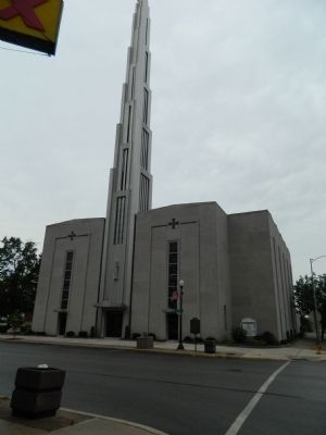
Father Tolton, the first negro priest in the United States, was born of slave parents in Brush Creek, Missouri, in 1854. Educated at Quincy schools, he returned to this city after his ordination in Rome, Italy, in 1886. He celebrated his first . . . — — Map (db m58799) HM
On Maine Street, on the right when traveling east. Reported missing.
Statesman and politician Stephen A. Douglas began his distinguished national career in Quincy. A resident of the city from 1841-1847, he served as Associate Justice of the Illinois Supreme Court from 1841-1843, then in the U.S. House until he was . . . — — Map (db m149962) HM
On Maine Street east of North 4th Street (U.S. 24), on the right when traveling west.
Mormons in Missouri were forced to flee their homes or face death because of an "extermination order" issued in 1838 by Governor Lillburn Boggs. Many of them crossed into Illinois at Quincy and were made welcome by the people here. In April 1839 . . . — — Map (db m149828) HM
On South 30th Street just south of Maine Street, on the right when traveling north.
The home of Major Thomas Scott Baldwin, aviation pioneer, once stood at this location. Baldwin invented the first folding parachute here in 1887, and by the 1890's had become one of the highest paid parachute exhibitionists in the nation. He built . . . — — Map (db m150016) HM
On U.S. 24 at State Route 96, on the right when traveling west on U.S. 24.
In 1673 the areas of the Mississippi and Illinois Rivers were explored by Frenchmen Louis Joliet and Father Jacques Marquette. Their voyages resulted in French claims on the area until 1763 when, by the Treaty of Paris, France ceded the land to . . . — — Map (db m150015) HM
On Washington Avenue (U.S. 60/62) at Fort Defiance Road, on the right when traveling north on Washington Avenue.
Pierre Francois Xavier de Charlevoix, a French Jesuit, reported as early as 1721 that the land at the confluence of the Mississippi and Ohio Rivers would be a strategic location for settlement and fortification. Nearly a century later, in 1818, the . . . — — Map (db m144870) HM
On Bunch Road west of Illinois Route 3, on the right when traveling south.
In 1673 Louis Jolliet and Father Jacques Marquette explored the Illinois country for France. By the 1763 Treaty ending the French and Indian War, this area passed to England. During the American Revolution, George Rogers Clark's men captured it for . . . — — Map (db m161171) HM
In 1817 the Zebulon M. Pike reached St. Louis, the northern-most steamboat port on the Mississippi River. The western steamboat of later years was a credit to the frontier American mechanic who drew upon experience to build a large craft (eventually . . . — — Map (db m161177) HM
On Old U.S. 51 (Illinois Route 37) 1.1 miles south of Redman Road.
Pierre Francois Xavier de Charlevoix, a French Jesuit, reported as early as 1721 that the land at the confluence of the Mississippi and Ohio Rivers would be a strategic location for settlement and fortification. Nearly a century later, in 1818, . . . — — Map (db m161727) HM
On Jefferson Street at Shoal Creek Avenue, on the right when traveling west on Jefferson Street.
United Mine Workers of America (UMWA) president and Congress of Industrial Organization (CIO) founder John L. Lewis (1880-1969) came to Panama, Illinois, from Iowa with his family in 1908 to work in the mines; within one year he was president to . . . — — Map (db m186233) HM
On Highway 24 (U.S. 24) west of County Road 1250 E (County Route 1250), on the left when traveling west.
In 1824 Cornelius Vandeventer a native of Ohio, became the first permanent settler in this area. Additional pioneers came over the next few years from Kentucky, Tennessee, Virginia, and North Carolina. In 1829 Alexander Curry purchased a claim on . . . — — Map (db m149875) HM
On Main Street (State Highway 89), on the right when traveling south.
Just north of town are remnants of the Cherry Coal Mine, where 259 miners lost their lives in one of the worst mine disasters in United States history.
The St. Paul Coal Company began mining coal at Cherry in 1905 and by 1909 was mining . . . — — Map (db m308284) HM
On East Peru Street (U.S. 6) just west of 8th Street, on the right when traveling west.
This two-story frame structure was the home of abolitionist Owen Lovejoy, who was born in Maine in 1811. Lovejoy moved into the house in 1838, when he became a Congregationalist minister. He was leader in the formation of the Republican Party in . . . — — Map (db m310285) HM
On West Dakota Street (U.S. 6) just east of North Strong Avenue, on the right when traveling east.
Pioneer resident of Spring Valley. Achieved national prominence in the settlement of the Pennsylvania Anthracite Miners Strike in 1902 with the co-operation of President Theodore Roosevelt. President of United Mine Workers, 1889-1908. Author of . . . — — Map (db m308286) HM
On South Spaulding Street at East Caroline Street, on the right when traveling north on South Spaulding Street.
Pioneer resident of Spring Valley. Achieved national prominence in the settlement of the Pennsylvania anthracite miners strike in 1902 with the co-operation of President Theodore Roosevelt. President of United Mine Workers, 1889-1908. Author of . . . — — Map (db m308287) HM
On West North Street (Illinois Route 92) at North 2nd Street, on the right when traveling east on West North Street.
Don Marquis, American humorist,
dramatist, and poet, was born in Walnut,
July 29, 1878. In 1899 he went to
Washington, D. C., where he began his
career in journalism. He later worked
on newspapers in Atlanta and New York
City. In Atlanta he . . . — — Map (db m230562) HM
On Chambers Road (U.S. 52) 0.2 miles south of Willow Road, on the left when traveling north.
The Stone Arch Bridge that stands to the east of the present highway was on the Galena Road, once the most important trail in northern Illinois. Along this route innumerable people streamed northward to the lead mines near Galena every spring and . . . — — Map (db m55806) HM
On U.S. 52 0.1 miles east of 7 Hill Road, on the left when traveling east.
Lewistown Trail ran from Springfield to Galena via Lewistown. From 1827 to 1837 it was one of the main routes to the Galena lead mines. In general the trail ran in a northerly direction, crossing the Rock River at Prophetstown. It then zigzagged . . . — — Map (db m34241) HM
On Unnamed campus entrance road 0 miles east of South Clay Street ( Route 78), on the right when traveling east.
Mount Carroll Seminary was founded as a coeducational institution in 1853 by Frances Ann Wood (later Mrs. Shimer). After the Civil War, enrollment was limited to women. Rechartered in 1896 as the Frances Shimer Academy of the University of Chicago, . . . — — Map (db m34479) HM
On Third Street at Madison Street, on the right when traveling north on Third Street.
Helen Scott Hay, famous Red Cross nurse, was born near Lanark in this county. She was a graduate of Savanna High School, Northwestern University in Evanston, and the Illinois Training School for Nurses in Chicago, where she was later Superintendent. . . . — — Map (db m55838) HM
On Unnamed Road in Old Mill Park 0.1 miles east of Chicago Avenue (U.S. 52), on the right when traveling east.
Steamboats once navigated to this point, where Plum River Falls powered saw, powder, grist, and flour mills at various times between 1836 and 1885. Near here the Rock Island Military and Prophetstown Trails to Galena were intersected as early as the . . . — — Map (db m34261) HM
On West Beardstown Street west of South Pitt Street, on the right when traveling west.
This is the site of the first building
erected as the seat of government of
Cass County, Illinois, on land provided by
Dr. H. H. Hall the founder of Virginia.
Circuit court was held here for the
first time in May, 1839 and the . . . — — Map (db m229610) HM
On Kennedy Drive west of Water Street, on the right when traveling west.
The first courthouse of Christian County (originally Dane County) was built in 1840 for $2,350. It was located in the center of Taylorville’s Public Square. Court was held on the lower level with County Officers sharing the upstairs floor. Since the . . . — — Map (db m29091) HM
On Illinois 49 0.1 miles south of E 1700th RD, on the right when traveling north.
Discovery of oil in Pennsylvania in 1859 created nationwide interest. Signs of petroleum
seepage had been observed in Illinois long before 1865 when one of the first wells was drilled
about ½ mile north and ¼ mile east of here on the farm of T R . . . — — Map (db m248173) HM
On Darwin Ferry Road at North Union Street, on the left when traveling east on Darwin Ferry Road.
Darwin was the Clark County seat from 1823 to 1838. The County Courthouse was one block south from 1819 to 1823. The county seat was Aurora, once located two miles north. Two blocks east was the Darwin Steamboat Landing on the Wabash River. The . . . — — Map (db m152464) HM
On Interstate 70, on the right when traveling west.
Hiram B. Trout and his brother, Everett Trout, were born on a farm about five miles north of this location. They operated a machine shop in Shelbyville, Illinois in the late 1800’s at which in time they invented and patented the unique design for . . . — — Map (db m59336) HM
On National Road (Avery Avenue) (U.S. 40) east of Oak Crest Road, on the right when traveling west.
This Bridge was completed by Army Engineers sometime between 1834 and 1837 as part of the Old National Road, between Cumberland, Maryland and Vandalia, Illinois, was authorized by the enabling act of 1803 and was the Nation's first federally . . . — — Map (db m71127) HM
On East Clarksville Road (County Route 2150 N) 0.6 miles east of North 580th Street, on the right when traveling east.
On this site stood Margaretta Post Office, which served many northwestern communities of Clark County from 1840 to 1861. It was named for Margaret, wife of the postmaster, William B. Marrs. Mail was carried to the post office first in saddlebags by . . . — — Map (db m184585) HM
On 1900th Street south of Hull Street, on the left when traveling south.
Fort Handy, built in 1816, was located 1200 feet southeast of this park on a knoll. The fort, the only structure of its kind in Clark County, was built by the family of Thomas Handy and contained three cabins and a well surrounded by a bulletproof . . . — — Map (db m152478) HM
On West Lincoln Street (County Route 31) at South Fulton Street, on the right when traveling west on West Lincoln Street.
For more than fifty years Westfield College was located on this site. It was founded as a seminary in 1861 by the United Brethren in Christ and incorporated as a college in 1865. The school was coeducational from the beginning and in some years . . . — — Map (db m184588) HM
On County Road 1200E 0.1 miles south of U.S. 50, on the right when traveling south.
Near this site was the home of Brevet Major General Lewis B. Parsons, who lived in Flora from 1875 until his death in 1907. Born in New York in 1818, Parsons graduated from Harvard Law School and began practice in Alton, Illinois. In 1854 he moved . . . — — Map (db m98934) HM
On 1st Street at Fairfax Street, on the right when traveling north on 1st Street.
This bridge was built in 1859 at a cost of $40,000 and used for nearly seventy years. Previously, travelers at Carlyle crossed the Kaskaskia by ferry or on a mud bridge supported by logs. The Historic American Buildings Survey recognized the . . . — — Map (db m98933) HM
On Jackson Street east of 6th Street, on the left when traveling east.
On December 25, 1830, the Illinois General Assembly created Coles County. At this time, Charleston became the county seat and was just a hamlet called "Coles Courthouse." In 1831, a log-cabin courthouse was constructed. About four years later, a . . . — — Map (db m188293) HM
On 7th Street at Jackson Avenue, on the left when traveling north on 7th Street.
On March 28, 1864, a gunfight erupted here between Union soldiers and Civil War opponents known as "copperheads." In eastern Illinois the Republicans were uniformly pro-Union, but many Democrats were pro-Southern.
Disturbances had occurred . . . — — Map (db m188295) HM
On E Street 0.1 miles south of West State Street ( Route 316), on the right when traveling south.
On September 18, 1858, Springfield attorney and former U.S. Congressman Abraham Lincoln debated U.S. Senator Stephen A. Douglas at the Coles County Fairgrounds during the senatorial campaign of that year. The Charleston debate was the fourth of . . . — — Map (db m184632) HM
On Lincoln Highway Road south of County Route 150N, on the right when traveling south.
Here on January 31, 1861, President-Elect Abraham Lincoln visited his stepmother, Mrs. Sarah Bush Lincoln and her daughter Mrs. Reuben Moore (Matilda Johnston). This was his last visit to Coles County before leaving Illinois for his inauguration. . . . — — Map (db m30888) HM
On East Lincoln Highway Road west of County Road 1300E, on the right when traveling west.
In Shiloh Cemetery are the graves of Thomas and Sarah Lincoln, father and step-mother of Abraham Lincoln. On January 31, 1861, shortly before assuming the presidency, Lincoln came here from Springfield to visit his father's grave in company with his . . . — — Map (db m188284) HM
On County Route 040 N east of Route 1420 E, on the right when traveling east.
In 1837 Thomas Lincoln erected a cabin on a tract of land situated one-half mile to the east. Here he resided until his death in 1851. Abraham Lincoln visited here frequently, and after 1841 held title to forty acres of land on which his parents . . . — — Map (db m30933) HM
On South Lincoln Highway, on the right when traveling east.
Members of Civilian Conservation Corps Co. V-2657 SP-52 built their barracks on this site in August 1935. The WWI veterans who comprised this CCC encampment named it Camp Shiloh after the burial place of Thomas and Sarah Lincoln. Like all CCC camps . . . — — Map (db m229793) HM
On North 19th Street (U.S. 45) at Western Avenue, on the left when traveling south on North 19th Street.
With the fortunes of conventional warfare turning rapidly against the Confederate States of America in early 1864, the Confederate government chose to embark on a formal campaign of behind-the-lines insurrection, subversion and sabotage in the . . . — — Map (db m188422) HM
On East County Road 330N east of North County Road 650E (County Route 19), on the right when traveling west.
From 1831 to 1834 Thomas and Sarah Lincoln, father and stepmother of Abraham Lincoln, lived in a cabin which stood a short distance to the north. It was their first home in Coles County, and their second home in Illinois. — — Map (db m188282) HM
On Shelby Avenue east of North Second Division Street, on the right when traveling east.
In 1859 the Mattoon Union Agricultural Fairgrounds, encompassing a 90-acre rectangle north and west of this location, was established by the Union Agricultural Fair Association, an organization of Mattoon men. The Union Fairgrounds consisted of . . . — — Map (db m188562) HM
On North Pike Street north of Route 133, on the right when traveling north.
This was the home of Dr. Hiram Rutherford, who was involved in 1847 in a case in which Abraham Lincoln represented a slaveholder. Rutherford and Gideon Ashmore harbored a family of slaves who had sought their help. The slaves belonged to Robert . . . — — Map (db m30877) HM
On State Street at State Line Avenue, on the right when traveling west on State Street.
Two blocks north of this corner the funeral train of President Abraham Lincoln entered Illinois at approximately 10:15 a.m. on May 1, 1865, on the Michigan Central Railroad right-of-way.
In the autumn of 1869, the founders of the State Line . . . — — Map (db m229880) HM
On 134th Place at St. Lawrence Avenue, on the right when traveling east on 134th Place.
From the 1830s until the Civil War, many enslaved African descendants in the South escaped to Chicago on their way to freedom in Canada. Black and white abolitionists in the region were part of the networks of assistance known as the Underground . . . — — Map (db m261050) HM
On East 35th Street at South Lake Park Avenue, on the left when traveling east on East 35th Street.
Stephen Arnold Douglas, one of the most distinguished statesmen of his day, was a
Justice of the Illinois Supreme Court, Member of the House of Representatives, and
United States Senator. Although a political rival of Lincoln, he supported the . . . — — Map (db m120707) HM
On Science Drive at South Lake Shore Drive, on the right when traveling north on Science Drive.
The Norway Building stood on this site for the 1893 World's Columbian Exhibition. After the Fair Chicago millionaire C.K. Billings purchased the structure and moved it to his estate in Lake Geneva, Wisconsin. William Wrigley of chewing gum fame . . . — — Map (db m125028) HM
On Calumet Ave at 18th Street, on the right on Calumet Ave.
From roughly 1620 to 1820, the territory of the Potawatomi extended from what is now Green Bay, Wisconsin, to Detroit, Michigan, and included the Chicago area. In 1803, the United States government built Fort Dearborn at what is today Michigan . . . — — Map (db m67806) HM
On South Wood Street near West Taylor StreetThi when traveling south.
First Game: May 14, 1893 (Cincinnati 13, Chicago 12)
Last Game: October 13, 1915 (Chicago 7, St. Louis 2)
Seating Capacity: 16,000
Career Record at West Side Grounds: 1,018 wins, 640 loses
World Series Champions: 1907, 1908
National . . . — — Map (db m82399) HM
On North Willard Court at North Milwaukee Avenue, on the right when traveling north on North Willard Court.
At 4 P.M. on January 17, 1992, a series of explosions and fires ravaged the River West community. The fires were in an area bounded by the Chicago River, the Kennedy Expressway, and Kinzie and Division Streets. The devastation was caused by . . . — — Map (db m61460) HM
Near South Michigan Avenue north of East Ida B. Wells Drive, on the right when traveling south.
At this site on November 18, 1915, was founded the American Medical Women's Assoc., dedicated to the support of women physicians and women's health. As its founder and first president, Bertha Van Hoosen, M.D., demonstrated her dedication to the . . . — — Map (db m237431) HM
On South Wabash Avenue north of Balbo Avenue, on the right when traveling north.
For over a half century, this building housed the headquarters of the Company which has come to be known as Brunswick Corporation. Then called the Brunswick-Balke-Collender Company, it moved here in 1913 after a fire destroyed its previous home. The . . . — — Map (db m237407) HM
On West Wacker Drive at North LaSalle Street on West Wacker Drive.
While still partially tied to its dock at the river’s edge, the excursion steamer Eastland rolled over on the morning of July 24, 1915. The result was one of the worst maritime disasters in American history. More than eight hundred people . . . — — Map (db m244410) HM
On West Monroe Street at South Sangamon Street, on the right when traveling east on West Monroe Street.
This park is named for Mary Bartelme (1866-1954), a pioneering Illinois Lawyer. Bartelme became the first female judge in Illinois (1923) and the second female judge in the United States. Born at Fulton and Halsted Streets in Chicago, she became a . . . — — Map (db m132021) HM
Near West Jackson Boulevard just east of South Clinton, on the left when traveling east.
The Milwaukee Road (Chicago Milwaukee St. Paul and Pacific Railroad) was one of the three railroads that built Chicago’s Union Station. In 1956, the Milwaukee Road was the third largest railroad in track mileage (15,846) and sixth largest in . . . — — Map (db m298730) HM
Near South Harlem Avenue (Illinois Route 43) south of Forest View Terminal Drive.
Here you stand at the west end of a 7.5 mile long water and overland travel route across a continental divide between the St. Lawrence and Mississippi River systems, known as the Chicago Portage. Well-known to Native Americans, the route was first . . . — — Map (db m157109) HM
On North River Road, on the right when traveling south. Reported damaged.
Josette Beaubien, a survivor of the Fort Dearborn Massacre, was buried here in 1845. She was married to Jean Baptiste Beaubien, one of Chicago's first settlers. Her brother was Claude LaFramboise, a chief of the Potawatomi Indians. Chief Alexander . . . — — Map (db m55452) HM
Kennicott House was built in 1856 by John A. Kennicott, a prominent Illinois physician, horticulturist, and educational and agricultural leader. Kennicott moved to the Grove from New Orleans with his family in 1836 shortly after the birth of his . . . — — Map (db m55575) HM
On Dixie Highway at Hickory Road, on the right when traveling south on Dixie Highway.
Dixie Highway was the first national road linking industrial northern states to agricultural southern states. Several governors met in 1915 to consider an improved road to Miami. Ten states lobbied for inclusion, resulting in eastern and western . . . — — Map (db m87086) HM
On Maple Avenue at Presidents Drive, on the right when traveling east on Maple Avenue.
Opening on July 3, 1926, with the American Derby and a $100,000 purse, Washington Park Racetrack, built by Washington Park Corporation and Illinois Jockey Club, became a home for the nation's finest thoroughbreds. Colonel Matt Winn and the . . . — — Map (db m306895) HM
On Forest Ave 0.1 miles south of Washington Boulevard, on the right when traveling north.
The site of present-day River Forest was once home to prehistoric Native Americans, who constructed large effigy mounds throughout the region. Soon after the American Revolution Chippewa, Menominee, and Potawatomi Indians moved onto the landscape, . . . — — Map (db m94461) HM
On Longcommon Road at Pine Avenue, on the right when traveling south on Longcommon Road.
Designed in 1869 by Frederick Law Olmsted and Calvert Vaux, the Village of Riverside, one of the first planned suburbs in the United States, influenced much of American community design. The site, on a curve of the Des Plaines River, had been a . . . — — Map (db m290094) HM
Near Cottage Grove Avenue 0.2 miles south of 183rd Street.
In the spring of 1934, Camp Thornton opened on this site as a home to young men of the Civilian Conservation Corps (CCC). At first, the men slept in tents in grass and weeds three feet tall. Later they built their own military style barracks with . . . — — Map (db m148602) HM
On Scott Avenue at Old Green Bay Road, on the right when traveling north on Scott Avenue.
One branch of the Green Bay Trail traversed this region. Originally an Indian trail, after 1816 the route connected Fort Dearborn at Chicago with Fort Howard at Green Bay. Couriers faced hunger, cold and Indians to carry dispatches on a round trip . . . — — Map (db m66618) HM
On North 1550th Street north of 1600th Avenue, on the right when traveling north.
Hutsonville was named after the Isaac Hutson family massacred by Indians in 1813 at a spot sixty four rods due east of this marker. Hutson was killed later in a skirmish with the Indians near Fort Harrison, Indiana. — — Map (db m152463) HM
On South Main Street at East Grand Prairie Street, on the right when traveling north on South Main Street.
On this block Mary Ann (Elwell) Gogin operated a General Merchandise Store in the late nineteenth century.
One of the first women in Illinois to own and manage her own store. Mrs. Gogin was affectionately known as "Auntie" to the residents of . . . — — Map (db m23315) HM
On South Jackson Street north of East Harrison Street, on the right when traveling north.
Here stood the home of Edward N. Cullom who with Joseph Kitchell platted the Village of Palestine in 1818. They donated to the county the land including the Public Square for the County Seat. Early court sessions were held in the Cullom home. — — Map (db m23311) HM
On South Lincoln Street north of East Lamotte Street, on the left when traveling north.
Here stood the Dubois Tavern. Jesse K. Dubois, a close friend of Abraham Lincoln, was an official in the United States Land Office in Palestine from 1849-1853 and later became the Auditor of Public Accounts for Illinois. His son, Fred T. Dubois, . . . — — Map (db m23309) HM
On Illinois Route 33 at North Highway Street, on the right when traveling west on Illinois Route 33.
About 1813 the William Eaton family and other restless pioneers considered Fort LaMotte too crowded and therefore constructed a new stockade on a site several hundred yards North of here. A family trait of the Eatons, large feet, led to the name . . . — — Map (db m23319) HM
On East Lamotte Street at South Leaverton Street, on the right when traveling east on East Lamotte Street.
About 1812 the settlers in this area built Fort LaMotte for protection from hostile indians.
The pioneers farmed the adjoining land but stayed within easy reach of the protective walls.
After the War of 1812 the Indian threat diminished and . . . — — Map (db m23308) HM
On South Pike Street north of West Grand Prairie Street, on the left when traveling north.
On this site stood the home of Augustus C. French (1808-1864) when he was elected the ninth Governor of Illinois.
The early settlers in Illinois came mostly from Southern States so that French, a native of New Hampshire, was the first "Yankee" . . . — — Map (db m23318) HM
On East Grand Prairie Street at South Lincoln Street, on the left when traveling east on East Grand Prairie Street.
Two early residents of Palestine, John Houston and Francis Dickson, purchased this lot as the site for a combination dwelling and store about 1818.
By 1820 their stock of merchandise provided nearby settlers with goods which they previously had . . . — — Map (db m23313) HM
On Illinois Route 33 north of Vincennes Ave., on the left when traveling north.
In this area Joseph Kitchell who settled here in 1817 erected a Grist Mill and Distillery which eliminated the trip to Shakertown, Indiana where the farmers had previously taken their grain.
Horses were used for power, grain was taken in pay, . . . — — Map (db m23307) HM
On East Main Street (Illinois Route 33) at North 1725th Street, on the right when traveling west on East Main Street. Reported missing.
This area reminded Frenchman John LaMotte of the land of milk and honey, Palestine. While a member of the LaSalle exploring party, he became separated from the group, traveled down the Wabash River, and first gazed upon the region in 1678. Other . . . — — Map (db m23328) HM
On North Main Street at East Market Street, on the right when traveling north on North Main Street.
A United States Land Office was located at this site in 1820 and operated until 1855. Settlers from as far as Chicago came here to file on homesteads.
Young Abraham Lincoln passing through Palestine in 1830 with his family in emigrant wagons . . . — — Map (db m23316) HM
Near West Lincoln Highway (Illinois Route 38) east of West Locust Street, on the left when traveling east.
This house, built in 1861, was the home of Joseph Glidden, who in 1873 invented barbed wire fencing. With Phineas W. Vaughn he perfected a machine to manufacture it. DeKalb was the home of Isaac L. Ellwood and Jacob Haish, also manufacturers of . . . — — Map (db m308288) HM
Near Sycamore Road (Illinois Route 23) 0.1 miles north of Gateway Drive, on the right when traveling north.
DeKalb's roots date to 1912 when a group of farmers and bankers formed the DeKalb County Soil Improvement Association to improve area farming. In 1917, an offshoot was formed, the DeKalb County Agricultural Association, with a focus on quality seed. . . . — — Map (db m230905) HM
On Roberts Lane south of Roberts Circle, on the right when traveling south.
Success in developing and commercializing hybrid seed corn in the 1930s and early 1940s prompted DeKalb Agricultural Association in 1944 to see if the principles of hybridization could be applied to the breeding of poultry. Association President Tom . . . — — Map (db m230904) HM
On Oak Street west of North 4th Street, on the right when traveling west.
Known for his inventive genius, eccentric personality, and generous philanthropy, Jacob Haish is perhaps most remembered as an inventor of barbed wire. Born in Germany, he immigrated to this country in 1832 and came to DeKalb County in the 1840s.
. . . — — Map (db m230903) HM
On North 4th Street north of Lincoln Highway ( Route 38), on the right when traveling north.
The DeKalb® brand winged ear logo is perhaps one of the most widely-recognized agricultural trademarks in the world. Over the years it has undergone many design enhancements from the original concept. But the same iconic image of a flying ear of . . . — — Map (db m230901) HM
On Clifford Drive just west of Hickory Street, on the left when traveling west.
In the early 20th century William George Eckhardt (1879-1959) was a pioneer in DeKalb County's leading role in agricultural innovation. Eckhardt, an agronomy professor at the University of Illinois, was an expert in the blossoming field of soil . . . — — Map (db m310352) HM
On Nelson Road north of Lincoln Highway ( Route 38), on the right when traveling north.
On this farm two entrepreneurs begin a small experiment in 1925, the results of which have helped transform agriculture and the economies of Illinois, this nation and the world. Driven by the desire to improve farmers' productivity, Charlie Gunn . . . — — Map (db m311831) HM
Near Bethany Road east of Sycamore Street ( Route 23), on the right when traveling east.
Hybrid corn results from the cross of two inbred parents, each of which is developed by selfing (in-breeding) a corn line for 6-8 generations until it is mostly homozygous.
Corn plants are diploid with one set of chromosomes coming from the . . . — — Map (db m230907) HM
On Fairview Drive east of Nelson Road, on the right when traveling east.
Many path-breaking agricultural innovations result from the creative minds of farmers. Such was the case in the development of the yield monitor, which measures grain yield and maps it to the specific part of a field as the grain is being . . . — — Map (db m312119) HM
Near Malta Road (County Highway 31) 0.1 miles north of Lincoln Highway (State Route 38), on the left when traveling north.
The Lincoln Highway was the first transcontinental, hard surface roadway in the United States. The Highway traversed 3,384 miles and twelve states - beginning in New York City and ending in San Francisco. Planned in 1913 by the Lincoln Highway . . . — — Map (db m230868) HM
On Railroad Street at North Lafayette Street, on the left when traveling east on Railroad Street.
In 1852, Sandwich pioneer William Patten returned from the gold fields of California with $2,000, a fortune at the time. With the coming of the Railroad in 1853, his son, Robert Patten, a carpenter, built the town's first lumberyard and steam . . . — — Map (db m264086) HM
On East Comanche Avenue (Illinois Route 30) at Indian Road, on the right when traveling east on East Comanche Avenue.
In the early 1800's Shabbona was a principal chief of the Ottowa, Potawatomi, and Chippewa group of tribes which banded together to form "The Three Fires." Shabbona camped briefly in a large grove one-half mile south of here. He fought with the . . . — — Map (db m313224) HM
Near West Prairie Drive east of Peace Road, on the right when traveling east.
In 1912, an enterprising and forward-thinking group of farmers, businessmen, and bankers joined together to form the DeKalb County Soil Improvement Association. This grassroots coalition became the DeKalb County Farm Bureau, the first Farm Bureau . . . — — Map (db m230909) HM
Near Aberdeen Court 0.1 miles south of Bethany Road, on the right when traveling south.
DeKalb Swine Breeders grew from the shared vision of two companies, Lubbock Swine Breeders Inc. (LSB) of Lubbock, Texas, and DeKalb AgResearch, Inc. (DeKalb) of DeKalb, Illinois, that synergistically combined to transform agriculture. LSB began . . . — — Map (db m230908) HM
On Edward Street east of South Avenue, on the right when traveling west.
In the mid to late 1800s, northern Illinois witnessed substantial agricultural innovations. Along with such developments as John Deere's steel plow and the barbed wire of Glidden-Ellwood-Haish, the Marsh Harvester brought significant change to . . . — — Map (db m310389) HM
On West Army Trail Boulevard at John F. Kennedy Drive on West Army Trail Boulevard.
This road followed an Indian trail that began in Chicago and went through DuPage, Kane, De Kalb, Boone, and Winnebago Counties to a Winnebago Village at Beloit, Wisconsin. In August, 1832, during the Black Hawk War, United States Army reinforcements . . . — — Map (db m47438) HM
On Geneva Road at Main Street, on the right when traveling east on Geneva Road.
Moses Stacy, soldier in the War of 1812, arrived here in 1835. This inn, built in 1846 and his second home, was a halfway stop between Chicago and the Fox River Valley and a probable stage stop for Rockford-Galena coaches. For many years the . . . — — Map (db m97573) HM
On Grace Street near Parkside Avenue, on the left when traveling south.
Built in 1839 and lived in by the Peck family until 1996, the Peck Homestead is significant locally, for the state of Illinois, and nationally as the home of Sheldon Peck, a radical abolitionist, keeper of a documented URR station and prolific . . . — — Map (db m255670) HM
Near S. Brainard Street 0.1 miles south of East Chicago Avenue. Reported permanently removed.
Near this site in 1832 a 100-foot square stockade enclosed by wooden pickets, with two blockhouses on diagonal corners, was built. Here Captain Morgan L. Payne and his company of forty-five men protected the settlers from roaming Sauk Indians during . . . — — Map (db m97574) HM
Near Brainard Street 0.2 miles south of Chicago Avenue, on the right when traveling west.
This land was home to the Potawatomi people before they were pushed out by waves of United States settler encroachment, federal policies of indigenous removal, and treaties negotiated under threat of military action. In this area, 1832, was a key . . . — — Map (db m257030) HM
On College Avenue near Washington Street, on the left when traveling east.
Before and during the Civil War, thousands of freedom seekers fled northward to escape bondage. Aided by abolitionists and other sympathetic allies, these men, women, and children often traveled by night on foot or by wagon, boat, or train. By day . . . — — Map (db m286023) HM
On Illinois Route 49 at Palmero Rd (County Road 1425), on the left when traveling south on Illinois Route 49.
Following the French and Indian War (1754-1763), France ceded all claims to their North American Territory, called New France, to England in the Treaty of Paris (February, 1763). English troops quickly occupied many former French forts and . . . — — Map (db m298874) HM
On Illinois Route 49 at Palermo Road (County Road 1425) on Illinois Route 49. Reported permanently removed.
On the site of Palermo, three miles east of here, according to tradition George Croghan, Deputy Supt. of Indian Affairs, met the Ottowa Chief Pontiac in July, 1765, and made preliminary arragements for the peace which ended the Indian uprising known . . . — — Map (db m299246) HM
On U.S. 150 0.3 miles north of County Route 2500N, on the right when traveling south.
A few miles west of here on July 18, 1765, Pontiac, an Ottawa Chief, and George Croghan, British Representative, met in a formal peace council which ended the most threatening Indian uprising against the British in North America. Following the . . . — — Map (db m10997) HM
445 entries matched your criteria. The first 100 are listed above. Next 100 ⊳