178 entries match your criteria. The first 100 are listed. The final 78 ⊳
Vexillology Historical Markers
This series is about flags, their origins and uses. It is not for flag dedications, unless the dedications indicates the history of the flag's development.
By Sandra Hughes, June 1, 2018
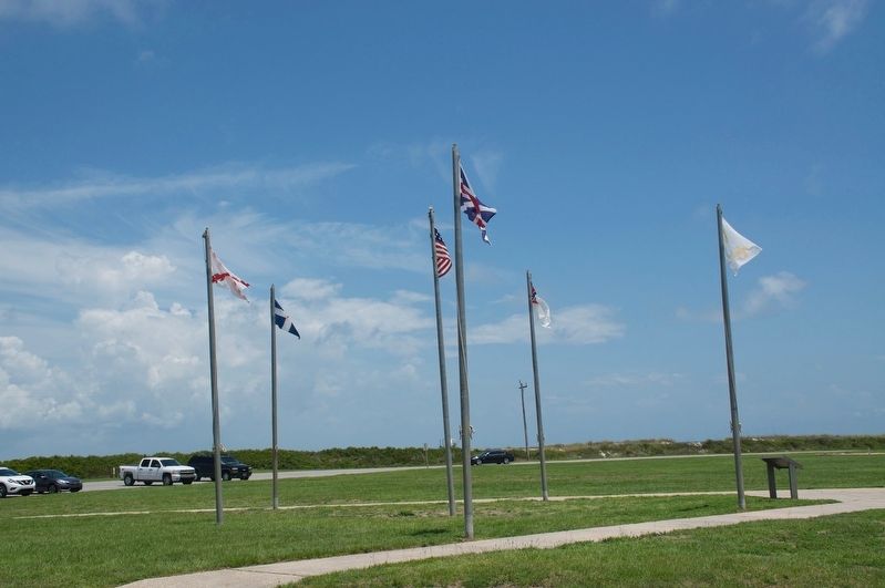
Colors of Significance Historic Flags of Mobile Point Marker
Traditionally referred to as "colors", flags have long been used to identify nations, loyalties, and movements. As the sands have shifted through the ages, so too have the colors and loyalties of the Gulf Coast. Displayed here are a small section of . . . — — Map (db m187336) HM
(East Face):
Tribute dedicated to the memory of the soldiers who gave their lives in the defense of our country here at Fort Morgan.
Here lies the pride of seven flags entombed in our ancestor’s worth, who heard the thunder of the fray . . . — — Map (db m4649) HM
The oldest remaining colonial settlement in East Alabama from Florida to the Tennessee line and older than the county of Henry and the state of Alabama. An active trading post was located here in the Alabama Territory on “The Hill” early in 1819. . . . — — Map (db m83757) HM
The "Stars and Bars," designed by Nicola Marshall of Marion, Alabama, was adopted by the flag selection committee of the Provisional Confederate Congress at Montgomery and raised over the capitol building on March 4, 1861. Its similarity to the . . . — — Map (db m69314) HM
The Stars and Bars
Designed by Nicola Marschall of Marion, Ala., and recommended by "The Committee On A Proper flag for the Confederate States of America". It was unfurled over the Capitol in Montgomery on March 4. 1861, while the . . . — — Map (db m224816) HM
The intensity of the war caused the desire for a new national flag that was in no way similar to the U.S. flag. The "Stainless Banner" was adopted by the Confederate Congress on May 1, 1863. The cross of St. Andrew, depicted on the flag, has been . . . — — Map (db m86423) HM
MG J.H.Wilson’s Cavalry Corps raised U.S. flag over Alabama’s and the Confederacy’s first Capitol on 4/12/65, three days after Lee’s surrender at Appomattox. Wilson had defeated LTG N.B. Forrest’s depleted and vastly outnumbered troops at the . . . — — Map (db m86471) HM
The Confederate Congress never issued any regulations specifying which type flag should be carried by regiments in the field. Early in the war, flags were made at home for presentation to individual companies. At first, national flags replaced . . . — — Map (db m86056) HM
Upon an outpouring of complaints that the 2nd national flag was too similar to a flag of truce, a red bar was added by act of Confederate Congress on March 4, 1865. Very few of these flags ever flew, however, as the war ended shortly thereafter. . . . — — Map (db m69326) HM
has been designated a
Registered National
Historic Landmark
under the provisions of the
Historic Sites Act of August 21, 1935
This site possesses exceptional value
in commemorating and illustrating
the history of the United . . . — — Map (db m181330) HM
The Arkansas Flag/Wabbaseka Memorial was founded by Jason Irby in 2013. Jason is an author and humanitarian who grew up in Wabbaseka and attended the public schools around the city. Jason attended Willie K. Hocker Elementary/Jr. High schools, . . . — — Map (db m169051) HM
Montrose merchants Bill Bailey and Vito Cannella dreamed of establishing a
"It all started in Montrose" National Week of Recognition to honor the American flag. Supported by the Rotary Club, the movement gained national appeal, and, in 1966, . . . — — Map (db m218223) HM
On November 20, 1818, in the closing years of the Spanish Era, Capitan Hippolyte Bouchard entered Monterey Bay with two ships, flying the flag of the United Provinces of the Rio de la Plata, Argentina. The next day, one ship attacked the Spanish . . . — — Map (db m66555) HM
Hippolyte Bouchard is celebrated in Argentina as a hero and patriot and founder of the Argentine Navy--the equivalent of John Paul Jones in American history. Argentina placed this monument in celebration of his 200th . . . — — Map (db m296607) HM
In 1870, the year in which the Groezinger Winery (now Vintage 1870) was built, these flags: the California Bear flag (note how much more primitive in design it is in contrast with the present day version) and the American flag (then with 37 . . . — — Map (db m103540) HM
On November 8, 1997, this Rainbow Flag was installed to commemorate the 20th anniversary of the election of Harvey Milk to the Board of Supervisors of voters of District 5. This victory by an openly gay man was a watershed for the Queer rights . . . — — Map (db m21083) HM
This Monument was erected by the Native Sons of the Golden West and the State of California to commemorate the raising of the Bear Flag on this spot June 14, 1846 by the Bear Flag Party and their declaration of freedom of California from Mexican . . . — — Map (db m161612) HM
The flag before you represents the flag that flew from Chief Black Kettle's lodge on the morning of November
29, 1864, when his encampment of friendly Cheyenne and Arapaho was brutally attacked by the Colorado
(U.S.) Volunteer Cavalry. The . . . — — Map (db m184925) HM
Residents of New Milford and Flag Lovers around the world will remember the renowned vexillologist for his generosity and kindness.
Peter organized a New Milford Flag Design Competition and a winner was selected by a panel of judges. . . . — — Map (db m230165) HM
In 1995, the International Bear Brotherhood flag was introduced to the world from within DC's own bear community. Today the flag is internationally recognized among this distinct culture of husky and hairy gay, bisexual and queer men.
The . . . — — Map (db m208485) HM
Lithuania
Capital Vilnius
Population 2.88 Million
Primary Export Refined fuel
Flag Fact
Lithuania's flag features three equal horizontal bands of yellow (top), green, and red. The color yellow symbolizes golden fields, . . . — — Map (db m113333) HM
The first national flag of the Confederate States of America, also called the “stars and Bars,” was adopted by the Confederate government in March of 1861, during the war between the Union and Confederacy.
Florida seceded on January 10, . . . — — Map (db m198355) HM
1513
Spain
Ponce De Leon claimed Florida for Spain, first placed around St. Augustine
1565
France
Flew at Fort Caroline near Jacksonville, Spain defeated France 1565
1763
Britain
Britain . . . — — Map (db m198976) HM
Jean Ribault led nearly 200 French settlers from Spain’s established colony near present day St. Augustine north along the St. John’s River.
Their mission was to claim an area near present-day Jacksonville and drive out the territory’s . . . — — Map (db m198351) HM
Great Britain’s Union Jack was flown over Florida representing the combined kingdoms of England and Scotland.
The Red Cross of St. George, the patron saint of England, and the white Scottish cross of St. Andrew form the Union flag. . . . — — Map (db m198350) HM
Juan Ponce De Leon planted the castle and lion flag of King Ferdinand III to claim La Florida for the Spanish crown.
This flag, placed near present-day St. Augustine, was also used by Christopher Columbus to claim lands in the Americas . . . — — Map (db m198349) HM
When Florida became a U.S. Territory, the American flag had 23 stars. A 27th star was added to the U.S. flag in 1845 after Florida became the the 27th state.
After the Civil War, the nation’s flag contained 36 stars. Old Glory’s number of . . . — — Map (db m198346) HM
The flag you see flying on the forward mast is called a Union Jack. It is a maritime flag flown on the bow of commissioned vessels while moored or at anchor. The Union Jack was adopted on June 14, 1777 along side the U.S. national flag. Since then, . . . — — Map (db m292331) HM
Spaniards first settled Florida permanently at the site of St. Augustine in 1565. They raised their vivid red and white flag to establish possession of the land for their king.
The Spanish flag flew over the little garrison town for 235 years, . . . — — Map (db m112507) HM
On this site in 1835 Joanna Troutman gave to a company of Georgia soldiers on their way to fight for the independence of Texas, a “Lone Star” flag, which she had made and which was later adopted as the Texas emblem. — — Map (db m28024) HM
The ladies of an illustrious company leaving Montgomery, Ala. after the Confederate Congress adopted the Stars and Bars March 4, 1861 had the West Point train stopped at Grantville, Ga. to buy material for a flag. This they made and unfurled first . . . — — Map (db m284555) HM
During the Civil War, both the Union and the Confederacy carried flags into battle. Commanders and units also carried their own battle flags and banners so that their men
could rally “round the flag.” The battlefield was a colorful . . . — — Map (db m170991) HM
First National Flag (Stars and Bars)
The first official flag of the confederacy was the Stars and Bars, and was reported to the provisional congress of the C.S. by the flag committee on March 4, 1861. It appears to have not had a recorded . . . — — Map (db m90441) HM
The Corps of Discovery were the first U.S. citizens to reach the Northwest by land, strengthening the American claim established in 1792 when mariner Robert Gray discovered the Columbia River.
When Lewis unfurled the Stars and Stripes, he . . . — — Map (db m109463) HM
Is it possible to wave the flag too much? Provided, of course, that you wave it with integrity? Is it possible to study Lincoln or Shakespeare too much? Is it possible to read the Bible too much ★ The great, the good, the true, are . . . — — Map (db m274331) HM
1500's Spanish Ownership
1702 French trading post and mission
1757 French fortification to block British expansion into Mississippi River, named Fort Massac
1764 French abandoned fort to British
1778 George Rogers Clark . . . — — Map (db m154811) HM
The four flags that fly on Bicentennial Plaza, hold special meaning for Illinois. Each is a 21-star flag, which became the official U.S. flag on July 4, 1819, to recognize the admission of Illinois as the 21st state in the Union on Dec. 3, . . . — — Map (db m285219) HM
French Royal Flag 1370 - 1600
French Merchant Flag 1661 - 1790
Royal Flag & Ensign Of France Circa 1679
British Red Ensign 1663 - 1707
Union Flag Of Great Britian 1707 - 1801
Continental Colors Or Grand Union Flag 1776 - 1777
Fifteen . . . — — Map (db m242209) HM
Site of presentation of an American Flag to Company F. 7th Indiana volunteer Infantry Regiment August 20, 1861. The 34-star flag, sewn by ladies of Hopewell Presbyterian Church, was received at a farewell picnic in a grove on the John H. Van Nuys . . . — — Map (db m66782) HM
★ Vietnam 1964-1973 ★
★ Peacekeepers 1967-present ★
From our first official national flag in 1777 to today, the United States has had 27 different official national flags. As states joined the Union, colorful and . . . — — Map (db m238977) HM
At centennial of statehood in 1916, Indiana lacked a unique state flag. The Indiana DAR spearheaded a movement to create a design by hosting a state flag competition. Mooresville watercolorist and John Herron Art Institute instructor Paul Hadley . . . — — Map (db m99004) HM
European interest was first represented in the “New World” by the Viking Banner of Leif Ericson and other intrepid Norse adventurers. This banner, according to tradition, made its way to Iceland, Greenland and presumably North America . . . — — Map (db m56936) HM
During the 1700’s, the political and economic interests of the colonists began to enlarge and disputes began to develop with Great Britain. After the defeat of the French and their expulsion in 1763, the colonists could focus even more of their . . . — — Map (db m56943) HM
As secession swept the South, various state banners were created to symbolize the "independence" movement. Soon the Confederacy found it necessary, however, to adopt an appropriate "national" flag. The first was the famous Stars and Bars. During . . . — — Map (db m107792) HM
With the admission of Alaska in 1959 and Hawaii in 1960, the present fifty-star flag came into being. Like other flags of our nation, the fifty-star flag has seen the varied conditions that can beset a dynamic association of peoples. Under it, the . . . — — Map (db m56971) HM
Like the new nation, the first Stars and Stripes would see fuller development with the passage of time. Under the much-debated Articles of Confederation of 1781, it was agreed that America would create self-governing States in the western domain . . . — — Map (db m56959) HM
The obligations and responsibilities of becoming an imperial power as a result of the Spanish-American War quickly multiplied. The international problems that arose in Latin America, in the Philippines, and in China saw the first application of . . . — — Map (db m56970) HM
The United States emerged from the ordeal of the Civil War with deep gulfs of mistrust and bitterness. Reconstruction was lengthy. Then during the 1870's the natural wealth of the country, the industrious people, further expansion beyond the . . . — — Map (db m56967) HM
With the Revolution won and the signing of the Treaty of Paris in 1783, the United States was extended westward to the Mississippi River. To the west of the Mississippi, the French Tricolor waved over French Louisiana until the purchase of that . . . — — Map (db m56947) HM
The first national flag is commonly identified as the Grand Union Flag. Although it was never officially approved or recognized, it was this flag that came to symbolize the growing pride in the name America and the strengthening union between the . . . — — Map (db m56945) HM
With the signing of the Declaration of Indepenence, the Grand Union was automatically promoted to the status of a national banner and at the same time rendered obsolete. The British ties were snapped and the crosses of St. Andrew and St. George in . . . — — Map (db m56946) HM
Between 1818 and 1861 no less than 13 changes were made in the Stars and Stripes as a result of the westward expansion. With the admission of Kansas in 1861, the [S]tars and [S]tripes became a thirty-four star flag. It was this flag that would be . . . — — Map (db m56962) HM
In 1603, St. George’s Cross was joined with St. Andrew’s Cross, the Scottish Flag, to form the famous Union Flag or “Union Jack” of Great Britain. It was this flag which flew over the first British colonies in North America at Jamestown . . . — — Map (db m56939) HM
Many people assume the only flag flown by Americans during the American Revolution
(1775 to 1783) was the Betsy Ross flag, but nothing could be further from the truth. The Betsy Ross flag was not created until 1777, two years into the . . . — — Map (db m278110) HM
Confederate Flag of Welcome. With the Confederate occupation of Hickman and Columbus in the late summer of 1861, Paducahans were thrilled and flew a large Confederate flag to welcome Southern Army thought on way. As Gen. Grant's Union forces, . . . — — Map (db m158735) HM
Louisiana seceded from the Union January 26, 1861, and a blue pelican flag replaced the U.S. flag. The National Flag of Louisiana, adopted February 12, 1861, became the second state flag until Louisiana joined the Confederacy March 21. There were . . . — — Map (db m91827) HM
The first usage of the Pelican Flag as emblematic of Louisiana in unknown, but references to flags with a pelican design were made long before the Civil War. The flag was officially adopted by the State Legislature July 1, 1912. On the flag appears . . . — — Map (db m91068) HM
Design
The black and gold design on the flag is the coat of arms from the Calvert line. It was granted to George Calvert as a reward for his storming a fortification during a battle. The red and white design is the coat of arms of the . . . — — Map (db m114857) HM
On April 19, 1861, Confederate sympathizers attacked the 6th Massachusetts Infantry Regiment as it changed trains en route to Washington, which the secessionists hoped to isolate. To learn more about the Baltimore Riot, the city’s role in . . . — — Map (db m6208) HM
On April 19, 1861, Confederate sympathizers attacked the 6th Massachusetts Infantry Regiment as it changed trains en route to Washington, which the secessionists hoped to isolate. To learn more about the Baltimore Riot, the city's role in . . . — — Map (db m219588) HM
The Flag House was the home of Mary Pickersgill and the site where she sewed the Star-Spangled Banner.
Mary Pickersgill moved into the Flag House in 1807 with her mother, Rebecca Young, and her daughter Caroline, and set up a flag making shop.
. . . — — Map (db m2723) HM
―――――――――★―――――――――
The flag that flew from the ramparts at Fort McHenry and inspired the famous poem by Francis Scott Key was sewn . . . — — Map (db m122314) HM
The forts walls are called ramparts. An American flag flies over Fort McHenry twenty four hours a day by Presidential Proclamation.
The size of the flag varies. On clear days with the right amount of wind, a full-size replica of the . . . — — Map (db m61434) HM
By order of the President, the flag of the United States of America flies day and night here at the place where Francis Scott Key saw it when he wrote “The Star-Spangled Banner.”
Without words, the unfurled flag answers Key’s immortal . . . — — Map (db m194615) HM
The Ridgely Flag was designed by Yolanda Mayers in honor of the town's Sesquicentennial Celebration. The flag incorporates elements of Ridgely history. The town colors are a perfect backdrop for the "Dream City" banner and train number 513 in . . . — — Map (db m205483) HM
During the Civil War, some Westminster families supported the Confederacy while others stood by the Union. Among the latter was Mary Ann “Mollie” Huber, who organized a dozen other like minded ladies into a sewing circle that met at her house. . . . — — Map (db m201643) HM
As the Confederate army marched through Frederick on September 10, 1862, feisty local Unionists—mostly women—showed their defiance by waving the Stars and Stripes. The poet John Greenleaf Whittier immortalized one of them in “The Ballad of Barbara . . . — — Map (db m2693) HM
After Confederate Gen. Robert E. Lee's smashing victory over Union Gen. John Pope at the Second Battle of Manassas, Lee decided to invade Maryland to reap the fall harvest, gain Confederate recruits, earn foreign recognition of the . . . — — Map (db m249951) HM
On September 9, 1862, the running engagement between Illinois, Indiana, and Virginia cavalry units that began the day before in Poolesville continued in Beallsville when two Federal regiments forced the single regiment of Virginia cavalrymen . . . — — Map (db m1681) HM
Ships use flags to communicate and to identify each other. These five flags are replicas of historic flags and ensigns (national flags flown at sea) used during the Barbary War and the War of 1812.
Star Spangled Banner
USS . . . — — Map (db m193742) HM
From 1715 to 1761, the pure white flag of France flew over Michilimackinac. The Fleur-de-lis, although part of the official royal flag of France, was rarely used on flags in French Canada. The white flag, flown over all ships and coastal forts, . . . — — Map (db m273832) HM
Flags have flown over Fort Mackinac since British soldiers constructed the post in 1780 during the American Revolution. A symbol of authority and national pride, the fort flag was faithfully raised by soldiers at the beginning of every day. In good . . . — — Map (db m279352) HM
The Stars and Stripes originated as a result of a resolution offered by the Marine Committee of the Second Continental Congress at Philadelphia, Pennsylvania and adopted June 14, 1777. — — Map (db m81111) HM
Bourbon Flag of France (1682-1763)
The Bourbon Flag of Louis XIV, King of France, was raised in the Mississippi River Delta in 1682 by Rene-Robert Cavalier Sieur de La Salle who navigated the Great River from his base in Canada to the . . . — — Map (db m289408) HM
Confederate Battle Flag
This battle flag, often called the Southern Cross flag, is the flag most often associated with the Confederate States of America (CSA) today. The Army of Northern Virginia first used the design as a square flag. . . . — — Map (db m91054) HM
Stars and Bars Flag
Adopted in March 1861, the Stars and Bars was the first national flag officially used by the Confederate States of America (CSA). Seven stars represented each of the seven original states of the CSA. The flag gained stars . . . — — Map (db m91051) HM
The 50-star flag was ordered by former President Eisenhower on August 21, 1959, and was adopted in July 1960. This was due to Hawaii being granted statehood. It is the longest-used version of the U.S. flag and has been in use for over 56 years. — — Map (db m194810) HM
The Flag that flies above is a reproduction of the Flag of Fort Mercer This flag was the lanyard at the Battle of Red Bank in 1777. There is no known reason the flag was designed in reverse of Old Glory. This flag was donated and maintained by . . . — — Map (db m99108) HM
By special Act of Congress, the Betsy Ross flag is flown here 24 hours each day. This is to commemorate Washington’s Army having encamped in this area June 14, 1777, the day Congress adopted the Flag Resolution. The period of encampment extended . . . — — Map (db m7759) HM
When New Mexico attained statehood in 1912, it did not have a state flag. In 1915, Colonel Ralph Emerson Twitchell designed a flag to mark the new state's participation in the 1915 Panama-California Exposition in San Diego. It featured a . . . — — Map (db m269683) HM
The white flag was the French naval ensign. It was also the flag flown over all forts that came under the royal authority in New France from the end of the seventeenth century until the British Conquest. — — Map (db m126270) HM
The original Pride flag created in 1978 by Gilbert Baker symbolized visibility, inclusion and pride for all members of the LGBTQ community. In 2018 designer David Quasar added a five colored chevron to the classic rainbow flag to place a . . . — — Map (db m175838) HM
The Flag of Honor contains the names of all those who perished in the World Trade Center, at the Pentagon, and aboard United Flights 175 and 93 and American flights 11 and 77 on September 11, 2001 and in the February 26, 1993 bombing of the World . . . — — Map (db m60370) HM
On Nov. 10, 1974 the nation’s first MIA banner and flag pole was dedicated under a resolution conceived by Commander Thomas C. Bushing. — — Map (db m28721) HM
A handmade U.S. Flag made on direction of Newark Valley native, Sgt. Roland Noble, 260th Inf., 65th Div., 3rd U.S. Army, first flown at Linz, Austria 8 May 1945. Believed by Gen. “Blood and Guts” George S. Patton, commanding U.S., 3rd Army, to be . . . — — Map (db m220126) HM
Realizing the addition of a new star and new stripe for each new state was impractical, Congress passed the flag act of 1818 making the design 13 stripes and 20 stars for the 20 states. It became the official United States flag on April 13, 1818. . . . — — Map (db m295678) HM
Colorado entered the Union in 1876 and that brought the need for a 38-star flag, which was introduced in 1877. This flag incorporated the Betsy Ross circle of 13 stars within the concentric circle of stars, plus a star in each corner. This design . . . — — Map (db m295686) HM
On July 4, 1912, the U.S. flag grew to 48 stars with the addition of New Mexico and Arizona. Arrangements of the stars ordered to be in six horizontal rows of eight each. A single point of each star to point upward.
This flag was official . . . — — Map (db m295688) HM
Upon admission of Hawaii as a state in 1959, a fiftieth star was added to this flag of the United States. The stars were arranged in nine rows staggered horizontally and eleven rows staggered vertically.
On July 4, 1960 this became the 27th . . . — — Map (db m295691) HM
The "Betsy Ross Flag", with the stars arranged in a circle, first appeared in the early 1790's. Although popularly believed that she made the first American flag at the request of George Washington, there is no historical verification of the . . . — — Map (db m295677) HM
On April 12, 1861, this flag was flying over Fort Sumter in Charleston Harbor, South Carolina when Confederate batteries under the command of General P.G.T. Beauregard opened fire on the fort to begin the Civil War or War Between the States. Note . . . — — Map (db m295683) HM
The Gadsden Flag is one of the United States historical flags that displays the rattlesnake. It was presented to the Continental Congress by Colonel Christopher Gadsden of South Carolina. The Gadsden Flag was used on revolutionary warships as the . . . — — Map (db m295666) HM
As the flag of the Revolution, it was used on many occasions. It was the first flown by the colonial fleet on the Delaware River. Later the flag was raised on the Liberty Pole at Prospect Hill near George Washington's headquarters in Cambridge, . . . — — Map (db m295670) HM
Several different "Great Star" designed flags were used between 1837-1845 and all depicted a star within a star pattern. All show a large star in the center surrounded by five stars forming a star pattern, then twenty stars forming a larger star . . . — — Map (db m295680) HM
The Guilford Courthouse Flag is a military banner which reportedly flew at the Battle of Guilford Courthouse. Recognized by the reverse colors from the American flag during the Revolution. Soldiers carried flags featuring common American symbols . . . — — Map (db m295675) HM
June 14, 1777, the Second Continental Congress passed the flag resolution which stated "the flag of the United States be 13 stripes alternate red and white, that the union be represented by 13 stars white in a blue field, representing a new . . . — — Map (db m295674) HM
Known as the "Rebellious Stripes," this flag was officially adopted by the Sons of Liberty, a secret society that began in Boston and New York but soon expanded throughout the American colonies. Many distinguished patriots, such as Samuel Adams, . . . — — Map (db m295668) HM
Prior to 1956 the Army was the only service without a flag. Today's army flag was dedicated on June 14 (Flag Day) in 1956. The flag displays a replica of the war office seal. The Phrygian cap within the replica has the motto "This We'll Defend" . . . — — Map (db m295698) HM WM
The nine stripes of the vertical Sons of Liberty flagbrepresented the nine protesting colonies that participated in the Stamp Act Congress of 1765. The
flag's 9 vertical red and white stripes were symbolic of "45" the number of the pamphlet . . . — — Map (db m266648) HM
178 entries matched your criteria. The first 100 are listed above. The final 78 ⊳