On Court Street just south of Ellis Avenue, on the right when traveling south.
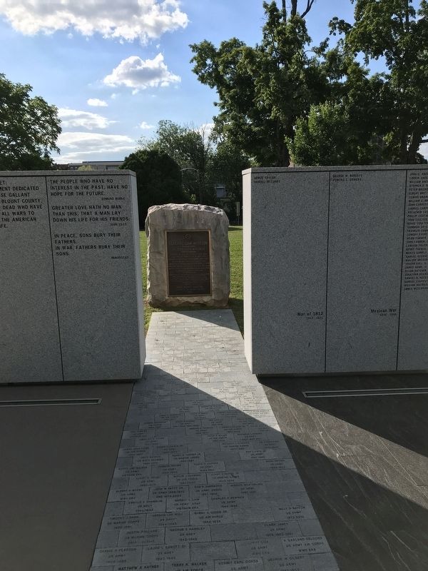
Citizen of Blount County 1806-1818
Enlisted at Maryville in War 1812
Congressman from Tennessee 1823-1827
Governor of Tennessee 1827-1829
Liberator of Texas San Jacinto April 21,1836
President Republic of Texas 1836-1838, 1841-1844 . . . — — Map (db m150794) HM
On Calderwood Highway (U.S. 129) 0.1 miles south of Hutton Ridge Road, on the left when traveling south.
Established by James Houston in 1785, it stood about 300 yards east on Little Nine Mile Creek. From here, in 1786, John Sevier led 160 horsemen against the Cherokee towns. In 1788, the Kirk family was massacred about three miles south; shortly . . . — — Map (db m58500) HM
On South Washington Street (State Highway 35) at Sevierville Road, on the right when traveling south on South Washington Street.
Site of the original settlement of Maryville. Here Captain John Craig in 1785 erected a fort on Pistol Creek to protect settlers from Indian raids. In 1793 as many as 280 men, women, and children lived within its walls for several months, surviving . . . — — Map (db m58839) HM
On East Broadway Avenue (U.S. 411) south of North Court Street, on the right when traveling south.
Louis Philippe, Duke of Orleans
and later king of France, lived in
exile in the United States in 1797.
Following a route designed by
President George Washington he
toured the South in that year. On
April 29 he spent the night here
at Woods . . . — — Map (db m150836) HM
On E. Lamar Alexander Pkwy (Route 321), on the right when traveling east.
Founded in 1819 by the Synod of Tennessee, Presbyterian Church in the USA, as The Southern and Western Theological Seminary, its first president was Rev. Isaac Anderson, D.D. Its original buildings were on Broadway at College Street. Receiving its . . . — — Map (db m36993) HM
Near McCammon Avenue at McGhee Street, on the left when traveling east.
During the antebellum period, Blount County supported abolitionism. In 1822, local Quakers and other residents formed an abolitionist society, and in the decades following, local clergymen preached against the evils of slavery. When the county . . . — — Map (db m69452) HM
On West Broadway Avenue (Tennessee Route 411), on the right when traveling east.
Dedicated with great affection and esteem by former students to the memory of Professor Charles William ("Bill Joe") Henry (1878-1935) and Mrs. Leola Landon Henry (1884-1966). Married January 1904. Founders and operators of Maryville Polytechnic . . . — — Map (db m107920) HM
On Broadway Avenue (State Highway 33), on the right when traveling east.
7 ½ mi. S, this resort was termed the Saratoga of the South in stagecoach days. First advertised in 1832; Daniel Foute built a log hotel there in 1837. In 1853, Asa Watson, of Mississippi, built the Seven Gable Hotel. Sidney Lanier spent much . . . — — Map (db m81363) HM
On West Broadway Avenue at Cates Street, on the left when traveling west on West Broadway Avenue.
This Presbyterian church was founded in 1786 by Rev. Archibald Scott, of Virginia. In 1792, Rev. Gideon Blackburn built a log church here; the stones in the present wall are from a church which replaced it in 1829; the brick church replaced it in . . . — — Map (db m28733) HM
On Wildwood Springs Road at Wildwood Road, on the right when traveling east on Wildwood Springs Road.
Chartered in 1806. Opened in 1808. Occupied two Maryville sites from 1808 to the Civil War. Reopened at Wildwood in 1872 on a five acre tract donated by Thomas J. Pritchett and wife Mary. Academy land and buildings were deeded to Blount County in . . . — — Map (db m150839) HM
On West Broadway Avenue (U.S. 411) at West Lamar Alexander Parkway (U.S. 321), on the right when traveling north on West Broadway Avenue.
Dr. Samuel Pride, first Worthy Master of the New Providence Masonic Lodge, built his house here. Maj. Gen. W. T. Sherman, enroute to the relief of Burnside at Knoxville, billeted himself here. From 1878 to 1900 it was the Friends’ Normal Institute. . . . — — Map (db m58509) HM
On Broadway Avenue (State Highway 33), on the right when traveling east.
Maj. Gen. W. T. Sherman, U.S.A., arrived in Blount County with 25,000 men, Dec. 5, 1863, to relieve Gen. Ambrose Burnside besieged at Knoxville by Gen. James Longstreet. The 15th Corps camped around Maryville, the 11th around Louisville and the 4th . . . — — Map (db m58836) HM
On East Broadway Avenue (Tennessee Route 33) at East Lincoln Road, on the left when traveling north on East Broadway Avenue.
Three miles south is the school-house built in 1796 by Andrew Kennedy and Henry McCulloch for their children. Sam Houston taught here in 1811 or 1812. He later became Governor of Tennessee, Commander-in-Chief of the Texas Army, President of the . . . — — Map (db m109629) HM
On West Broadway Avenue (Tennessee Route 411) at West Lamar Alexander Parkway (Tennessee Route 321), on the right when traveling east on West Broadway Avenue.
Four separate plaques. (Text of each plaque under the photos below.) — — Map (db m107921) HM
On U.S. 411, 0.5 miles north of Henry Lane, on the right when traveling north.
On the hill to the south, beside the Great War and Trading Path, later the Federal Road, Samuel Henry, Sr., built a fort by 1792. The half-breed John Watts and 200 followers attacked it in August, 1793. Henry’s first mill was authorized in 1795. He . . . — — Map (db m58508) HM
On Tuckaleechee Pike east of Walland Gap Drive, on the right when traveling east.
Erected near Indian
War Path
1790
Gift of descendants of
Josias Gamble
and Ann Gamwell
Marker placed by
Mary Blount Chapter
DAR 1940 — — Map (db m195414) HM
On Montvale Road (State Road 336) 0.3 miles south of Blockhouse Road, on the right when traveling south.
For more than 200 years the Black Sulfur Spring has been a landmark location in Blount County. The spring and 215 acres was bought from David Delzell in 1834 to become one of three primary mineral springs for Daniel Foute's 6,500 acre Montvale . . . — — Map (db m164837) HM
On West Broadway Avenue at South Cedar Street, on the right when traveling south on West Broadway Avenue.
Built by Mr. Pete Hood c. 1910
has been placed on the
National Register
of Historic Places
by the United States
Department of the Interior — — Map (db m184598) HM
On Broadway Ave. at Cusick St., on the right when traveling west on Broadway Ave..
Here, where Blount County's first courthouse stood, Sam Houston "took a dollar from the drum", thus marking his first enlistment in the United States Army, March 24, 1813. This culminated in his command of the Army of Texas, which decisively . . . — — Map (db m28579) HM
On West Broadway Avenue at Gary H. Hensley Drive, on the right when traveling east on West Broadway Avenue.
William B. Scott, Sr., a free Black, migrated to East Tennessee in 1847 after increased racial tension in North Carolina. He made harnesses and saddles in Blount County’s Quaker community of Friendsville until the Civil War. In Knoxville, during . . . — — Map (db m107600) HM
On Old Knoxville Highway (Tennessee Route 33), on the right when traveling north.
Nicholas Bartlett built a mill 300 ft. downstream about 1785. When Blount County was created in 1795, its mill-pond was a turning point from the Stock Creek boundary to run toward Bay's Mountain. The mill was used as a fort in the Indian troubles . . . — — Map (db m109333) HM
On Old Knoxville Highway (Tennessee Route 33), on the right when traveling north.
Knox County
Established 1792; named in honor of
Maj. Gen. Henry Knox
Washington's Chief of Artillery in the Revolutionary War. Secretary of War in Washington's Cabinet. One of the founders and first secretary of the Society of the . . . — — Map (db m109332) HM
On Highway 411 at Burnett Station Road, on the right when traveling south on Highway 411.
Early settlers coming down the Great War & Trading Path in 1784-85 camped here; it was the scene of their first death and burial. In 1786 the Rev. Archibald Scott of Virginia organized a Presbyterian congregation in the area; the church was built . . . — — Map (db m81365) HM
On Sevierville Road (Tennessee Route 411), on the left when traveling east.
One mile south, near a large spring, Robert McTeer built a fort and mill in 1784. A branch of the Great War and Trading Path passed nearby. Reportedly, the first school in what later became Blount County was held here; it was also the first polling . . . — — Map (db m108216) HM
On Montvale Road, 0.3 miles south of Deer Run Drive, on the right when traveling south.
Montvale Springs and Chihowee Mountain, eight miles south of Maryville, were inhabited by Native Americans for thousands of years. In 1832 Dantel Foute constructed a road from Maryville and built Montvale Springs Hotel, one of Tennessee's first . . . — — Map (db m203538) HM
Near Cades Cove Loop Road west of Parson Branch Road, on the right when traveling south.
In the early 1900s family farms covered the valley. Self-sufficiency was the rule in those days, but most people made use of the mill, the country store, and the blacksmith shop. The buildings assembled here represent part of a typical mountain . . . — — Map (db m58475) HM
On Cades Cove Loop Road, on the right when traveling east.
In Honor of the Civilian Conservation Corps 1933 – 1942 whose hands built roads, trails, bridges, buildings, campgrounds, and picnic areas in Great Smoky Mountains National Park for the benefit and enjoyment of the people. “If you . . . — — Map (db m58440) HM
On Wears Valley Road (U.S. 321) just north of Lamar Alexander Parkway (U.S. 321), on the right when traveling north.
This Irish patriot, exiled from his homeland for revolutionary newspaper activities, settled in the cove about two miles from here in 1855. After a short stay he moved to Knoxville. The rest of his life was taken up with lecture tours and newspaper . . . — — Map (db m56818) HM
On Cedar Creek Road, 0.6 miles north of U.S. 321, on the right when traveling west.
Justice of the Peace John Burns and his assistant William Dunn lost their lives in a dynamite explosion while widening this road in his capacity as road commissioner for the Fifteenth District during his term on the county court — — Map (db m164836) HM
On E. Lamar Alexander Pkwy (Route 321), on the left when traveling east.
This is the former site of the Little River Lumber Company mill complex. Founded in 1901 by Col. W.B. Townsend for whom this community is named, the company was one of the largest commercial lumber operations in the Smokies. From 1901 to 1939, the . . . — — Map (db m36995) HM
On US Hwy 321, 0.1 miles east of Old Tuckaleechee Road, on the right when traveling north.
Near here was one of these three Cherokee villages, unoccupied when settlers arrived about 1791. A branch of the Great War and Trading Path forked here, one to North Carolina, the other to villages on the Little Tennessee. The Virginia trader, . . . — — Map (db m46477) HM
On U.S. 321, 0.4 miles north of Foothills Parkway, on the right when traveling north.
A mile north, on Little River, Josias Gamble built a fort in 1740. Gov. William Blount came here in 1790, to pacify and disperse a gathering of settlers about to attack the Indians to recover stolen horses. The fort was never attacked, but was a . . . — — Map (db m46479) HM
Near Market Street NE north of Hiwassee Street (U.S. 11), on the left when traveling north.
It affords me sincere pleasure to apprise the Congress of the entire removal of the Cherokee Nation of Indians to their new homes west of the Mississippi. The measures authorized by Congress at its last session, with a view to the . . . — — Map (db m177976) HM
Near Market Street NE north of Hiwassee Street (U.S. 11), on the left when traveling north.
I have often wished to enjoy your company once more but it is very uncertain whether I shall ever again have that pleasure. If we Cherokees are to be driven to the west by the cruel hand of oppression to seek a new home in the west, . . . — — Map (db m177983) HM
On Market Street NE, 0.1 miles north of Hiwassee Street (U.S. 11), on the left when traveling north.
The full moon of May is already on the wane; and before another shall have passed way, every Cherokee man, woman and child in those states [North Carolina, Georgia, Alabama, and Tennessee] must be in motion to join their brethren in . . . — — Map (db m177955) HM
On Market Street NE, 0.1 miles north of Hiwassee Street (U.S. 11), on the left when traveling north.
We are overwhelmed! Our hearts are sickened, our utterance is paralyzed, when we reflect on the condition in which we are placed, by the audacious practices of unprincipled men...
— Principal Chief John Ross to the . . . — — Map (db m177958) HM
On Worth Street Northeast at Market Street Northeast, on the left when traveling east on Worth Street Northeast.
Charleston, formerly Fort Cass during the “Trail of Tears” (Indian removal of 1838), was strategically important in the military struggle for East Tennessee. The East Tennessee and Georgia Railroad bridge here, the line’s only crossing . . . — — Map (db m69343) HM
On Eureka Road NW (Tennessee Route 306) at Old Eureka Road NW, on the right when traveling north on Eureka Road NW.
John McPherson entered Cherokee territory as a miller and was an early settler in the Eureka Valley. In 1834 he was one of five founding members of Candies Creek Baptist Church. An active Unionist during the Civil War, he was imprisoned by the . . . — — Map (db m177951) HM
On Market Street NE north of Hiwassee Street (U.S. 11), on the left when traveling north.
I have all necessary preparations made, having upwards of 600,000 rations on hand, and boats and wagons sufficient to my command to carry [the Cherokee] off comfortably.
— General Nathaniel Smith to C.A. Harris, . . . — — Map (db m177965) HM
On Market Street NE north of Hiwassee Street (U.S. 11), on the left when traveling north.
Our situation is truly a critical one. Our whole country is full of troops and fortifications and should it be determined by the Govmt, to remove the Cherokees by force under the fraudulent Treaty by the kind of Soldiers which are . . . — — Map (db m177967) HM
On Market Street NE north of Hiwassee Street (U.S. 11), on the left when traveling north.
My troops already occupy many positions in the country that you are to abandon, and thousands and thousands are approaching from every quarter, to render resistance and escape alike hopeless. All those troops, regular and militia, are . . . — — Map (db m177970) HM
On Market Street NE, 0.1 miles north of Hiwassee Street (U.S. 11), on the left when traveling north.
The Cherokees are nearly all prisoners. They have been dragged from their houses, and encamped at the forts and military posts, all over the nation … Our brother [Jesse] Bushyhead and his family, Rev. Stephen Foreman, native . . . — — Map (db m177972) HM
Near Market Street NE north of Hiwassee Street (U.S. 11), on the left when traveling north.
[A]s a very natural result of collecting and marching … men, women and children of all ages and conditions, changing suddenly, and very materially all their habits of life … We should feel little astonishment at finding a high grade . . . — — Map (db m177973) HM
Near Market Street NE north of Hiwassee Street (U.S. 11), on the left when traveling north.
On last Friday two Cherokee men came into our camps … for the purpose of ascertaining whether any thing could be done for their relief. … They said they left their families sick and one of them said he had lost one of his children … . . . — — Map (db m177975) HM
On Market Street NE, 0.1 miles north of Hiwassee Street (U.S. 11), on the left when traveling north.
In truth, our cause is your own; it is the cause of liberty and of justice, it is based upon your own principles … Spare our people! Spare the wreck of our prosperity! Let not our deserted homes become the monuments of our . . . — — Map (db m177961) HM
On Market Street Northeast north of Cass Street Northeast, on the right when traveling north.
During the war, Henegar House’s occupants, as in many other Tennessee homes, were divided in their loyalties. Henry Benton Henegar, the owner, was a Unionist while his wife, Margaret Lea Henegar, was a secessionist. Whenever Confederates occupied . . . — — Map (db m69346) HM
Near Hiwassee Street (U.S. 11) north of Market Street NE, on the right when traveling north.
In December 1835, a small faction of Cherokee, led by Major Ridge, John Ridge, Elias Boudinot, and others, acting on their own and without the consent of Principal Chief John Ross, signed the Treaty of New Echota, setting the conditions for the . . . — — Map (db m177914) HM
Near Worth Street NE west of Market Street NE, on the left when traveling west.
In December 1835, a small faction of Cherokee, led by Major Ridge, John Ridge, Elias Boudinot, and others, acting on their own and without the consent of Principal Chief John Ross, signed the Treaty of New Echota, setting the conditions for the . . . — — Map (db m177984) HM
On Keith Street Northwest (U.S. 11) at Stuart Road, on the right when traveling north on Keith Street Northwest.
Here stood the home of John Walker, Junior, known as “Chief Jack”. A grandson of Nancy Ward, he was prominent in the affairs of the Cherokee nation, belonging to the party advocating a voluntary treaty of removal of the Cherokees to the . . . — — Map (db m81366) HM
On 2nd Street Southeast, 0.1 miles south of Linden Avenue Southeast, on the right when traveling south.
On this site in 1910, East Side School was constructed to serve as a three year City High School. The students then transferred to Bradley Central High School when it was completed in 1916. The school was renamed Allen Grammar School in honor of . . . — — Map (db m153740) HM
On North Ocoee Street (State Highway 74) just north of 22nd Street Northwest, on the left when traveling south.
On this site in 1916, Bradley Central High School began meeting the educational needs of
this community. Adopting its name from the county, which in turn was named in honor of Col. Edward Bradley, a veteran of both the Revolutionary War and the War . . . — — Map (db m153667) HM
On North Ocoee Street, on the left when traveling north.
This 1200 pound Meleeny bell (constructed in 1893) was housed in the bell tower of the Bradley County Courthouse until 1960. It was returned to its rightful place in front of the courthouse on Wednesday, February 5, 1992 by Mainstreet-Cleveland as . . . — — Map (db m208839) HM
On 2nd Street Southeast, on the left when traveling north.
Dedicated to the people of Bradley County who served and to those who gave their lives in the service of our country
Korea
1950 - 1955
Paul T. McCracken•
Roy L. Whaley•
James L. Evans•
John M. Cofer•
William D. Johnson•
Charles . . . — — Map (db m208838) HM
On North Ocoee Street, on the left when traveling north.
Erected to the memory of the men of Bradley County who gave their lives in the service of their country during the World War
Frank Barnes•
Calvin C. Climer•
Robert Daughtery•
Fred Farmer•
Ollie Goins•
James Haney•
Carter Hicks•
John F. . . . — — Map (db m208835) WM
On North Ocoee Street, on the left when traveling north.
Sojourner, stop for a moment and meditate on the names of the men of Bradley County who gave their lives in the second world war that you might continue to enjoy the priceless heritage of freedom
James D. Blankenship•
Billy V. Weaver•
A.R.T. . . . — — Map (db m208277) WM
On Dalton Pike (Tennessee Route 60) 0.4 miles south of Old Weatherly Switch Road SE (Tennessee Route 317), on the left when traveling south.
After battles at Chattanooga in November 1863, and before the Atlanta Campaign the following May, southern Bradley County lay between Union and Confederate lines at Cleveland, Tennessee, and Dalton, Georgia. Both armies scouted the area. Soldiers . . . — — Map (db m115884) HM
On North Ocoee Street (Tennessee Route 74) at 8th Street NE, on the right when traveling north on North Ocoee Street.
When you read about the history of the beginning of the Cleveland Bradley County Public Library as well as exploring all of its historical house portions on Ocoee Street, someone might think that the Library is nothing more than a collection of old . . . — — Map (db m184258) HM
On Inman Street East (U.S. 64) at Parker Street Northeast, on the right when traveling east on Inman Street East.
When the Civil War began, Cleveland was a divided community with most residents being sympathetic to the Union. Confederate troops occupied the area in 1861 to control the East Tennessee and Georgia Railroad and to protect the vitally important . . . — — Map (db m69342) HM
On 1st Street Northeast, on the right when traveling east.
Benjamin Cleveland was born in Virginia, later served in the North Carolina House of Commons and led the Wilkes County militia at the Battle of Kings' Mountain on October 7, 1780. This battle was considered a turning point of the American Revolution . . . — — Map (db m107924) HM
On Berry Street Northeast just south of Central Avenue Northeast, on the right when traveling north.
On this site in 1883, the first local school building for African-Americans was erected. In 1890, the school awarded four diplomas at its first commencement. The wooden building was razed in 1924, and a new brick structure was built to house grades . . . — — Map (db m153738) HM
On North Ocoee Street (State Highway 74) at 8th Street Northwest, on the left when traveling north on North Ocoee Street.
South (front) face
CSA
1861
1865
To our known
and unknown
Confederate dead
East face
1861-1865
Erected by, the
Jefferson Davis Chapter
United Daughters
of the Confederacy,
1910.
West . . . — — Map (db m153676) WM
Near Blythewood Road Southwest at Harris Creek Road Southwest, on the right when traveling north.
In 1873, Bennet Cooper (1797-1886) gave one-quarter of an acre of land for a family burying ground. His first wife, Lydia, was buried there along with several other family members. The cemetery is located on a ridge behind the Cooper Homeplace . . . — — Map (db m81367) HM
Near North Ocoee Street, on the left when traveling north.
Built in 1866 for the Pleasant Craigmiles family.
In 1923 the home was donated to the
City of Cleveland by the Johnston family in memory of their mother, Sarah Tucker Johnston.
The home was placed on the National Register of Historic . . . — — Map (db m227453) HM
On North Ocoee Street at 8th Street NE, on the right when traveling north on North Ocoee Street.
The Craigmiles House-Carmichael Annex was built before the Civil War and first served as the residence of Pleasant M. Craigmiles, his wife Caroline, and their children, Augusta, Walter, Fannie, Edward, and Frances Campbell. Sadly, only Augusta and . . . — — Map (db m184253) HM
On 6th Street Northeast, on the right when traveling north.
In honor of
Darlia McLuhan Conn
Darlia McLuhan Conn served the university as the presidential spouse for 34 years, 1986-2020. During that time, she was an adjunct member of the piano faculty in the School of Music, and her presence and . . . — — Map (db m227448) HM
On Bobby Taylor Avenue/1st Street NE at Lee Highway (Tennessee Route 74), on the right when traveling east on Bobby Taylor Avenue/1st Street NE.
Built in 1911
by
Will H. and John B. Fillauer
Restored in 1988
by
Bank of Cleveland
Board of Directors
Henry M. Barkley • Wm. K. Fillauer • John G. Haile • Fritz Harris • G. Robert Taylor • R. Scott Taylor • E. C. Thomas . . . — — Map (db m184268) HM
Built in 1967 to house male students for Lee College, Hughes Hall was razed in 2010 to create the Science and Math Complex quadrangle. — — Map (db m227450) HM
A building on this site housed the Lee College Music Department from 1947 to 1995; it was replaced by the current School of Music building on Parker Street. The building was two stories, a long rectangular structure with a single hallway from the . . . — — Map (db m227452) HM
On this site was an 850-seat auditorium with a balcony and large stage for theatrical productions. Built when Bob Jones College owned the campus, it was never given a name after Lee College bought the campus in 1947. (The auditorium had no bathrooms . . . — — Map (db m227451) HM
Near 12th Street SW west of Goode Street SW, on the right when traveling west.
First called City Cemetery, this is the resting place of both Confederate and Union soldiers. On November 4, 1862, a train wreck south of Cleveland killed 17 Confederate soldiers who are buried here in a mass grave. Nearby engagements in 1863 . . . — — Map (db m102186) HM
On North Ocoee Street (Tennessee Route 74) at 8th Street NE, on the right when traveling north on North Ocoee Street.
The Hardwick-Jarnagin House stands as the cornerstone of the Cleveland Bradley County Public Library's main complex. Joseph H. Hardwick purchased the property in 1881, and the home was completed in 1883. The original home, furnished in the latest . . . — — Map (db m184263) HM
On North Ocoee Street (Tennessee Route 74) at Centenary Avenue NW, on the right when traveling north on North Ocoee Street.
Since 1885 this campus has been dedicated to the purposes of Christian higher education. Lee College was founded by the Church of God as Bible Training School on January 1, 1918, on Caut Avenue in Cleveland. The school relocated in Sevierville in . . . — — Map (db m49558) HM
On North Ocoee Street (State Highway 74) just north of 6th Street Northeast, on the left when traveling north.
Masonic Lodge No. 134 and the town of Cleveland established the Masonic Female Institute in 1848 and opened the school in 1856. At the beginning of the war, student and diarist Myra Inman wrote of a disruption in the school's leadership: "Mr. . . . — — Map (db m153687) HM
On Central Avenue NW at Oak Street NW, on the right when traveling east on Central Avenue NW.
Chartered Dec. 16, 1837, this was the first such institution in the Ocoee Purchase; here was its home during its entire existence. An early teacher (1843) was Henry von Aldehoff, a native of Prussia and graduate of Bonn University. This building was . . . — — Map (db m49559) HM
On Montgomery Avenue NE north of 9th Street NE, on the right when traveling north.
Beginning in 192o, this site has variously served publishing, educational, worship and administrative ministries of the Church of God. The publishing ministry began with the first issue of “The Evening Light and Church of God Evangel” on March 1, . . . — — Map (db m184506) HM
One mile west was this Cherokee council ground. Here was held the last council between the United States and the Cherokee nation, preceding the removal of the Indians to Indian Territory, now Oklahoma. John Howard Payne, author of “Home, . . . — — Map (db m49722) HM
On North Ocoee Street, on the right when traveling north.
This historical marker is placed as a memorial to The Sousa Band Grand Concert
January 30, 1906
Craigmiles Opera House
Cleveland, Tennessee
presented
October 11, 2004
by
Lee University
Dr. Paul Conn, President
Lee University Wind . . . — — Map (db m208274) HM
On North Ocoee Street (Tennessee Route 74) at 8th Street, on the left when traveling north on North Ocoee Street.
These young men were killed in a R.R. wreck near Thaxton, VA, July 2, 1889 while en route to Europe.
The body of Will Steed alone was recovered and interred in the city cemetery.
This monument is erected in loving remembrance of the three by their . . . — — Map (db m227461) HM
On Old Blue Springs Road west of Blue Springs Road Southeast, on the left when traveling west.
After Union victories at Chattanooga in November 1863, the Union Army IV Corps's First Division, led by Gen. David S. Stanley, camped in this valley and made preparations for the Atlanta Campaign. By April 1864, more than 9,000 men were present, . . . — — Map (db m153744) HM
On Worth Street Southwest at 6th Street Southwest, on the right when traveling south on Worth Street Southwest.
This monument is to perpetuate the memory of the Boys in Blue in the war of 1861-65 who have lived in Bradley County was dedicated by Oviatt Post No. 20 G. A. R. May 30 1914 — — Map (db m153743) WM
On South Lee Highway (U.S. 64) at South McDonald Road, on the right when traveling east on South Lee Highway.
From Canasoga, near Wetmore, to Chiaha, near South Pittsburg. De Soto's expedition of 1540 followed the Great War and Trading Path, which ran from northeast to southwest, passing near this spot. — — Map (db m178048) HM
On Cove Lake Lane, on the left when traveling north.
Few men have the satisfaction of knowing they have made a contribution in their lifetime that will last through the ages and touch the lives of millions.
Men of the CCC know that, feeling well. The Civilian Conservation Corps was launched April . . . — — Map (db m130401) HM
Near Veterans Memorial Highway (Alternate Interstate 75) south of Lake Access Road, on the right when traveling south.
Imagine, 800 years ago on this site a thriving Indian village. The people farmed, fished, and worshipped their ancestors. Carved and painted pillars, colorful mats and sculptured figures, decorated 3 temple mounds. Burials, pottery, weapons, tools, . . . — — Map (db m218640) HM
On Veterans Memorial Highway (US 25W) at Park Road on Veterans Memorial Highway (US 25W).
1.5 miles to the southeast on Cove Creek. Joel E. Stone built a dam, grist mill and a saw mill, which he and his family operated until 1934 when Norris Lake was raised. The mill served the surrounding area as a community center and whistle-stop for . . . — — Map (db m74243) HM
On Main Street, on the right when traveling south.
Dedicated to the memory of our comrades of all wars who entered the service of their country from Campbell County and those who gave their lives on the field of honor "that this nation, under God, shall have a new birth of freedom - and that . . . — — Map (db m130976) WM
On U.S. 25W, 1.3 miles east of Highcliff Road, on the left when traveling east.
At 9:05 p.m. on Thursday, July 6, 1944, Southbound Troop Train #47 headed by L&N Engine #418 with 1000 soldiers aboard, crashed into the Clear Fork River at Highcliff, Tennessee, killing thirty-three soldiers and injuring ninety-eight. Engineer J. . . . — — Map (db m233103) HM
Tennessee Amvets dedicates this memorial to all veterans living or deceased who have honorably served their country that freedman may reign. Governor Don Sandquist — — Map (db m74228) WM
Near Interstate 75 north of 5th Street (U.S. 25W), on the right when traveling south.
Tennessee’s mountain residents were bitterly divided about secession in 1861, although most were Unionist. In Huntsville (Exit 141), Scott County residents voted to secede and join Kentucky if Tennessee joined the Confederacy.
Confederate . . . — — Map (db m219059) HM
On Indian Mountain State Park Circle, on the left when traveling north.
The Civil War in Campbell County was often personal. Few residents owned slaves, and a large majority – 1,094 to 60 – voted against secession in June 1861. Local men formed what became Co. A and Co. B, 1st Tennessee Infantry (US), at the . . . — — Map (db m119921) HM
On U.S. 25 at 1st Street, on the right when traveling north on U.S. 25.
Heth's Division, with the army's artillery and subsistence trains, passed into Kentucky through Walker's and Big Creek Gaps, while other combat elements of the Army of East Tennessee moved through Roger's Gap. The two columns reunited at . . . — — Map (db m121322) HM
7451 entries matched your criteria. Entries 201 through 300 are listed above. ⊲ Previous 100 — Next 100 ⊳