Coal Production
The Aladdin Coal Mine began operation in 1898. One of the earliest descriptions of the coal operations at Aladdin is provided by this 1899 Wyoming Coal Mine Inspector report:
Aladdin No. 1 - This mine is situated at . . . — — Map (db m98065) HM
During the summer of 1874, General George Armstrong Custer led the first official government expedition to the Black Hills, which the Sioux Indians claimed as their territory. Although the United States Government officially sent this expedition of . . . — — Map (db m34586) HM
By 1911 the industrial production of coal at the Aladdin Mine was dwindling. Later coal mining at the site was for domestic coal for heating and cooking. The coal was reportedly "a good coal which burned so hot it made the stove top rattle." The . . . — — Map (db m98061) HM
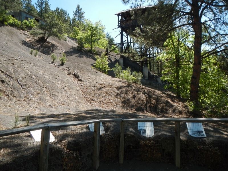
The hoist house (directly west) is a later addition to the coal mine. An internal combustion engine replaced the beasts of burden who originally hauled the coal from within the depths of the hillside. The hoist house is a simple 2 x 4 framed shed . . . — — Map (db m98091) HM
The structure before you is one of the last historic wooden coal tipples left in the west. The wooden tipple structure is an example of mine engineering technology used in the late 1800's and early 1900's. This type of structure is no longer used in . . . — — Map (db m98064) HM
The tilt of the tipple shown in the photos was the result of time and the elements. The degree of tilt and the fact that this structure did not completely collapse is remarkable. The corrosive nature of the coal slack waste piles caused the buried . . . — — Map (db m98063) HM
Plains Indians depended upon buffalo for many of their material needs - food, shelter, clothing, tools, fuel, ceremonial objects, even toys. Prior to acquiring horses in the 18th century, hunting individual animals on foot with bows and arrows was . . . — — Map (db m45545) HM
The enormous task of butchering began immediately after the kill. Adult men and women worked in teams to rapidly skin carcasses and begin cutting them into pieces small enough to be carried out of the sinkhole, possibly by adolescents. Meat . . . — — Map (db m113174) HM
The Vore site was discovered during the construction of Interstate Highway 90. A crew of archaeologists from the University of Wyoming spent two summers (1970 and 1971) determining the horizontal and vertical extent of the cultural materials . . . — — Map (db m113173) HM
Plains Indians required large quantities of meat and hides for food, shelter, clothing, and other material needs. Harvesting as many buffalo as needed by hunting on foot in the severe winter weather would be nearly impossible. Therefore, northern . . . — — Map (db m98094) HM
Look around you! This valley was an excellent habitat for buffalo. The herd-gathering area was open grassland north, west, and southwest of the sinkhole. Natural drainage supplemented by man-made structures provided drivelines. The sinkhole was an . . . — — Map (db m98095) HM
Indians used a combination of drivelines, controlled harassment, and decoys to move the herd toward the intended trap. Here at the Vore site, drainages were probably used to keep the herd together and headed in the desired direction. In . . . — — Map (db m113175) HM
Buffalo are fast, strong, and often unpredictable animals, but Indians understood bison behavior and used this knowledge effectively. For example, the Indians knew that manipulating herds of buffalo was easier than controlling individual animals. In . . . — — Map (db m98096) HM
The vast valley below was once an overflowing bounty of resources. The rich grasslands and forest flooded often with fresh water, attracting elk and bison to graze. The sacred bison gave life with every part of its body, providing food and shelter . . . — — Map (db m202617) HM
After landing a parachute atop the Tower, George Hopkins watched his 1,000-foot-long descent rope fall out of reach. It was his only way down. Stuck and afraid to fall asleep on the summit, Hopkins paced in the gusty October wind while rescue plans . . . — — Map (db m202615) HM
Devils Tower, an important landmark for Plains Indian tribes long before the white man reached Wyoming, was called Mateo Tepee, or Grizzly Bear Lodge, by the Sioux. A number of Indian legends describe the origin of Devils Tower. One legend tells . . . — — Map (db m34465) HM
Although Devils Tower has long been a prominent landmark in northeastern Wyoming. the origin of the mammoth rock obelisk remains somewhat obscure. Geologists agree that Devils Tower consist of molten rock forced upward from deep within the earth. . . . — — Map (db m97986) HM
President Theodore Roosevelt proclaimed Devils Tower a national monument on September 24, 1906.
President Roosevelt acted under the authority of of the Antiquities Act of 1906 which declared, "that the President of the United States is . . . — — Map (db m98001) HM
Music! Dancing! Baseball! Food! Drink! Friends! Relatives! All this and more took place at the Old Settler's Picnic. Pioneer gatherings at the Tower, usually on the 4th of July, started in the 1890s. These events drew hundreds for the biggest local . . . — — Map (db m98000) HM
The Tower boasts a rich and colorful climbing history. In 1893 two local ranchers first climbed the Tower using a wooden stake ladder (below). Forty-four years later, Fritz Wiessner made the first ascent using ropes and modern techniques.
The . . . — — Map (db m202612) HM
All climbers have a reason. The first climbers on record to summit Devils Tower, Willard Ripley and William Rogers, faced a bleak year on the ranch. Money was scarce, but Rogers had an idea. As Rogers gathered materials, Ripley built a ladder that . . . — — Map (db m202616) HM
Ever wonder what those big concrete pyramids down by the river are? Why are they there? How long have they been there?
Before the Keyhole Dam was built in 1952, the old bridge (built in 1928) across the Belle Fourche River was frequently . . . — — Map (db m113168) HM
Ancient rivers took millions of years to excavate Devils Tower. The waters carried away softer sedimentary rocks leaving behind the hard igneous rock called phonolite. This rock type is found here in northeastern Wyoming, and central Montana, but . . . — — Map (db m72588)
The Ft. Laramie treaties of 1851 & 1868 set aside the Black Hills for the Sioux, for as long as the grass shall grow and the river shall flow. Nevertheless, in 1874 Lt. Col. George Armstrong Custer was sent to investigate rumors of gold in the area . . . — — Map (db m42556) HM
Devils Tower, known as Bear's Lodge to Northern Plains Tribes, rises high above the Belle Fourche River, grasslands, and ponderosa pine forests. This major landmark of the Northern Great Plains has attracted people for thousands of years. Today, it . . . — — Map (db m34463) HM
The process began about 50 million years ago. Magma (molten rock) was injected into layers of sedimentary rock, forming the Tower one and one-half miles below the earth’s surface. It has since taken millions of years to erode away the surrounding . . . — — Map (db m72589)
Above ground, prairie dogs are usually looking for plants to eat, eating, or scanning for predators. At a warning bark, prairie dogs dive into a dark city of tunnels, where they spend more than half their lives. They play an important role in the . . . — — Map (db m71946)
The Tower and Black Hills area have been a gathering place and home to many people. Archeological discoveries show that native people lived here 10,000 years ago. As time passed, Arapaho, Cheyenne, Crow, Kiowa, Lakota, and Shoshone all developed . . . — — Map (db m72587) HM
Though rising only 600 ft above the floor of the plains, Inyan Kara Mountain stands
as one of the most important cultural and historical landmarks of the Black Hills. Inyan
Kara forms an important part of the sacred geography of the Black Hills . . . — — Map (db m98275) HM
The arid basins and prairies of Wyoming lie in the rain shadow of our great mountain ranges. The shortgrass prairie of eastern Wyoming and Colorado are also that is left of this native grassland type. Buffalo grass and drama grasses typify the . . . — — Map (db m97985) HM
Along this trail passed herds of cattle from distant Texas to replace the fast vanishing buffalo and build a civilization on the north-western plains. — — Map (db m97984) HM
Also known as "Temple of the Sioux," Sundance Mountain rises majestically in the southwest. It belongs to the Bear Lodge Mountain Range, which defines the northwestern edge of the Black Hills. It was named for the Plains Indians' religious . . . — — Map (db m45541) HM
The Red Valley surrounding you belongs to the transition zone between the flat, treeless Great Plains and the pine-forested Black Hills. Artesian springs and creeks draining from the hills and mountains create draws that provide water, shade, and . . . — — Map (db m45536) HM
The Black Hills area currently boasts Wyoming's largest population of white-tailed deer and wild turkeys. Pronghorn antelope, mule deer, red squirrels and sharp-tailed grouse are also common.
Excerpts from journals of the Colonel George Custer . . . — — Map (db m98137) HM
Serving as a western gateway to the Black Hills, Crook County, Wyoming is a place of beauty and diversity. The varied terrain includes the state's lowest elevation, 3,125 feet, situated north of the town of Aladdin, while rugged Warren Peak rises to . . . — — Map (db m98136) HM
In July 1874 Lieutenant Colonel George Armstrong Custer, and more that 1000 soldiers, camped near here while engaged in a military expedition to explore the Black Hills. The expedition's official purpose was to locate a suitable site for an army . . . — — Map (db m98140) HM
"What is there more kindly than the feeling between host and guest?"
- Aeschylus
Matthew S. Driskill, a valued member
of Wyoming's tourism industry,
embodied the true meaning of
hospitality by always treating
strangers as friends.
In . . . — — Map (db m186539) HM
Giant cypress trees growing today in swamps (or forested wetlands), such as these found in Louisiana's Pointe Lake, used to grow in Wyoming back when it was a warm, subtropical swamp - about 55 million years ago during the Late Paleocene epoch. Some . . . — — Map (db m45539) HM
The first Caucasian residents of this area came as prospectors following the Black Hills Gold Rush. In 1876 the glitter of gold led them from the large mining camps of Lead and Deadwood westward to Sand Creek, located near this site. Instead of . . . — — Map (db m45535) HM
Sundance Creek nature trail extends for six blocks between City Park and Sundance Pond near the Fairgrounds. Along this leisurely walk are interpretive signs for your information and enjoyment. This self-guided trail is provided to help you . . . — — Map (db m113171) HM
Harry A. Longabaugh served time in our local jail and did take his name from Sundance, WY. Commissioned by the Sundance Area Chamber of Commerce this statue was created by South Dakota native Edward E. Hlavka.
The full story and . . . — — Map (db m113202) HM
Lieutenant Colonel George A. Custer's Black Hills Expedition crossed northeastern Wyoming from July 17-25, 1874, camping within three miles of this location. forged by 1000 men (cavalry, infantry, teamsters, scientists, miners, newspaper reporters, . . . — — Map (db m45381) HM
Located a short distance to the east and camouflaged by the red eroded landscape is the Vore Buffalo Jump. This sinkhole served early residents as a slaughterhouse. using the natural pit as a trap, hunters would capture bison in late fall by running . . . — — Map (db m45537) HM
A Fire Lookout's Job
The men and women who work in fire lookout towers locate nearly 80% of wildfires in their area. The job of the Forest Service Lookout involves observing the heavens and earth for the telltale signs of a forest . . . — — Map (db m113169) HM
Centrally located on the gold-bearing vein in the area, mines literally surrounded Atlantic City by the fall of 1868. The townspeople soon fostered a thriving business community. In addition to sawmills and blacksmith shops, Atlantic City boasted of . . . — — Map (db m80134) HM
was established to protect from Indians the gold mining camps of South Pass City, Atlantic City, Miners’ Delight, and others. It was named for 1st Lt. Charles B. Stambaugh, 2nd Cavalry, U.S.A. who was shot from his horse by Indians when defending a . . . — — Map (db m80145) HM
In 1880, the population of Miner's Delight was 45, down from its peak of
around 100. One of the residents who remained through the 1880's was
territorial congressman James Kime. Kime, who settled here in 1869, is credited
as being Miner's . . . — — Map (db m173104) HM
Entering Miner’s Delight, you’ll be struck by the mystery and charm of an old west ghost town. The weather, brown logs command as much interest as a clear blue sky are reflected in the glassy surface of the beaver ponds. How do these buildings stay . . . — — Map (db m162424) HM
As the news of gold spread, the Sweetwater Mining District filled with miners who established Hamilton City about two miles east of here in 1867. The following year, the name of the town changed to Miners Delight, after a highly productive nearby . . . — — Map (db m80133) HM
In March, 1866, a battle was fought in this vicinity between Shoshone and Bannock Indians on one side and Crow Indians on the other.
The contest was waged for the supremacy of hunting grounds in the Wind River basin. Crowheart Butte was so named . . . — — Map (db m96243) HM
Portions of the High Plains were not settled until the early 20th century because water was needed for irrigation. Responding to pressure for Western settlement, Congress created the Reclamation Service in 1902. Its purpose was to develop water . . . — — Map (db m96242) HM
On the wind-blown mountain slopes south and west of Dubois winters the world’s largest herd of Rocky Mountain bighorn sheep. The bighorn once was found throughout all mountain habitats of the Rockies: today its range is but a remnant. The . . . — — Map (db m96241) HM
High in mountains where the natural environment changes swiftly, eroding or burying the past, for how long a time can vestiges of man's frailer achievements withstand obliteration? No matter!, for here man has brought or developed cultures which are . . . — — Map (db m180651) HM
Before primitive man discovered this pass between rich hunting grounds native ungulates grazed here during summers, migrating to the river valleys and plains for winters. These high plateaus and mountain meadows then harbored thousands of bison. . . . — — Map (db m180649) HM
Union Pass the cultural site must first have been Union Pass the natural site. As a natural site it commenced to produce vegetation and was afterwards inhabited by animals before it ever became attractive to man==for any purpose other than the . . . — — Map (db m180421) HM
Aesthetic and economic resources surround Union Pass, extending far to the west, north and southwest. These include grass, browse and forest plus animals living thereby and therein. Ownership of lands and vegetation repose in the nation's people; . . . — — Map (db m180423) HM
A road, component of a cultural environment, is the most noticeable feature of this otherwise natural landscape. In present form it is not old, not a pioneer route hacked by frontiersmen. Based and graded to support rapid haulage o ponderous loads . . . — — Map (db m180419) HM
Jutting like the topsail of a ship from beyond the apparent horizon. a tip of the Ramshorn is seen. It serves to remind the viewer of the Absarokas, a cragged mountain range broader and longer than the Wind Rivers but slightly less elevated. These . . . — — Map (db m180420) HM
Twelve thousand foot mountain plateaus dominating this view of Green River and Snake River headwaters seemingly provide a southwesterly buttress for loftier peaks forming the core of the Wind River Range. Beyond them it is 43 miles from Union Pass . . . — — Map (db m180653) HM
Southwest rises a mountain given a lyrical name, one such as Indians or mountain men discovering a geographical phenomenon might have chosen. Midway of its four-mile long crest is the key point, one of only two in North America, were as many as . . . — — Map (db m180333) HM
Hacked and Stacked
Ties were made from trees hacked and cut by hand...hence the name "tie hack." Tie hacks were a special breed of loggers who could quickly fell, limb a tree, and fashion the tie down to the specification demanded. . . . — — Map (db m96316) HM
Westbound Astorians led by Wilson Price Hunt in September, 1811, passed through Dubois region, over Union Pass, and on to the mouth of the Columbia River to explore a line of communication and to locate sites for fur trading posts across the . . . — — Map (db m96244) HM
Union Pass, so named in 1860 by Captain William F. Raynolds during the Hayden Surveys of Wyoming, provides access across the Continental Divide in the Northern Wind River Mountains. Ancient peoples used this pass for centuries, with use by fur . . . — — Map (db m96313) HM
At this pass--midst a maze of mountain ranges and water courses which has sometime baffled and repulsed them--aboriginal hunters, mountain men, fur traders and far-ranging explorers have, each in his time, found the key to a geographic conundrum. . . . — — Map (db m180331) HM
Postulating the traverse of the Continental Divide the eye climbs to Union Peck, some four airline miles but nearer six by that tortuous route. At ll,491 feet Union Peak is a nondescript rise that draws attention only because it is the final . . . — — Map (db m180418) HM
In Memory of Those Who Made the Supreme Sacrifice in World War II
Sherman Redman • Lee Wadda • Gordon E. Burt • Elwin Elmer • George W. Antelope • Claude Goggles • William Trosper • Loren McC. Frank • Richard Pogue • Louis Bishop • John L. Brown . . . — — Map (db m96240) WM
Sacred to the Memory of
Mrs. Maggie Richards
and
Mrs. Hall
Pioneer White Settlers
Killed July 23rd, A.D. 1873
by a raiding band of hostile Sioux Indians
in their ranch home
on the site of
the present city of . . . — — Map (db m96197) HM
(Three monuments are treated here as one marker:)
Sacajawea Died April 9, 1894
A guide with the Lewis and Clark Expedition
1805-1806
Identified, 1907 by Rev. J. Roberts who officiated at her burial
Dedicated in the . . . — — Map (db m96168) HM
Burial Register on File at Roberts Mission Pages 114-115 Day: 1884 • Date: April 9 • No.: 10 • Names: Bazil's Mother (Shoshone) • Age BCC: 100 • Residence: Shoshone Agency • Cause of Death: Old Age • Place of Burial: Burial ground Shoshone Agency • . . . — — Map (db m96203) HM
This cemetery is named for the Shoshone woman who became an invaluable guide, interpreter and translator to the Lewis and Clark Expedition.
Fifteen year old Sacajawea accompanied her husband, fur trader Charbonneau, when he joined the Corps of . . . — — Map (db m96202) HM
This tablet is erected to the memory of
The Right Rev. George Maxwell Randall, D.D.
Bishop of Colorado, Wyoming, and New Mexico. Born Nov. 23, 1810. Died Sept. 28, 1873. Who held his last service in this building on its former site at . . . — — Map (db m96201) HM
This school was founded by the Reverend John Roberts. Born in Wales, in 1853, Roberts was for 66 years a missionary to the Shoshones.
"Our hope is in the children and the young people, the old people can't hear!" So spoke Washakie, Chief of . . . — — Map (db m96167) HM
The Great Shoshone Chief, a skilled hunter, strategist, and warrior against his tribal enemies was noted for his friendship towards the white man. He united his people. He was born about 1804 and died February 20, 1900. Shoshone Indian Reservation . . . — — Map (db m96204) HM
Five hundred yards northwest of this marker stood the Bonneville Cabins, built by Captain B.L.E. Bonneville in 1835 to store his trade goods. Three cabins were constructed and later two more. They were long known as “The Five Cabins, : the . . . — — Map (db m80128) HM
In Memoriam
★ Christando, John ★ Hoyt, William David Jr. ★ Homec, Frank Edward ★ Gotten Gaspero ★ Valluskey, John Arthur
In Honor Of
Allen, John • Alexander, Sterling, Jr. • Burkus, Albert . . . — — Map (db m167192) WM
The Historic Mine Trail and Byway Program designated the Gold Flakes to Yellowstone Historic Mine Trail in 2005. This trail links significant finds of gold, iron ore, and uranium, each of which played important roles in Wyoming's history.
The . . . — — Map (db m67009) HM
Ice Slough is a small stream that flows into the Sweetwater River five miles east of here. In front of this point is a slough (i.e. a marsh or shallow un-drained depression). This slough gave the name to the stream east of here. In the "Ice Slough" . . . — — Map (db m62076) HM
Home on the range, a tiny community consisting of a post office, gas station, and a few souls, sat quiet and undisturbed along this lonesome stretch of highway until the 1950's. That all changed when the nation's uranium industry boomed after World . . . — — Map (db m67008) HM
The need was there
Competing with time, harsh climates, long distances, tough terrain and the hostility of numerous Indian bands, the Pony Express carried the mail 1600 miles across the West. From April 4, 1860 to October 24, 1861, . . . — — Map (db m69604) HM
Originally called the Emigrant Road, the Oregon Trail was the main route of westward expansion from 1812 to 1869. An estimated 500,000 people journeyed past here in search of new lands and new lives in the West.
Because of its unique shape, . . . — — Map (db m62092) HM
A famous natural landmark used by Indians, trappers, and emigrants on the Oregon Trail. Site of Split Rock Pony Express 1860-1861, stage and telegraph station is on the south side of the Sweetwater. Split Rock can be seen as a cleft on the . . . — — Map (db m67007) HM
Split Rock was a relay station during the turbulent 18 month life of the Pony Express. The Express operated at a gallop, speeding mail across the West in only 10 days. However, because of the "talking wire," its days were numbered. The telegraph . . . — — Map (db m69603) HM
Shoshone, Arapaho, Crow and Sioux Indians occupied this pleasant valley long before the Oregon Trail, which changed their cultures and life styles forever. This led to tragic warfare and the eventual loss of country they had called their own.
. . . — — Map (db m69602) HM
The Oregon Trail was American’s main street west. Building upon American Indians footpaths, emigrants bound for the Pacific Northwest used the trail. They were soon followed by Mormons fleeing persecution, gold seekers rushing to California and the . . . — — Map (db m95744) HM
Wild horses, managed by the Bureau of Land Management, live around Green Mountain which is located on the opposite side of the highway. You many see bands of wild horses roaming public land on the south side of the road.
Wild horses are distant . . . — — Map (db m95774) HM
“The Sinks” are a series of cracks and crevices at the back of the cavern before you. The water of the Popo Agie River flows into the Sinks. It then reappears at the “Rise of the Sinks,” a large calm pool ¼ mile down canyon. . . . — — Map (db m95824) HM
Viewed from Beaver Rim, the Wind River Mountains, part of the Rocky Mountain chain, boast 53 granite peaks over 13,000 feet high. The Continental Divide runs the length of the Wind River Range. Water on the east side of the Continental Divide flows . . . — — Map (db m67012) HM
This schoolhouse was built by John Borner along the Old Indian Trail near the mouth of Sinks Canyon. Mr. Borner was well known by residents of Lander for is large, plentiful garden. He was married in 1875 to Lena (Jenny) Canary, the sister of the . . . — — Map (db m95865) HM
This unique ornate building has been on Lander's Main Street since 1893. Built by Thomas J. Bossert and it was used for his dry goods store. He ran it as a "cash only" store. He advertised clothing at lower prices than every offered in Lander. He . . . — — Map (db m95870) HM
The Fremont served guests for eighty years on the corner of Main and 3rd, from 1891 to 1971. Jerry Sheehan had the foresight to build an out-of-the ordinary hotel in an isolated western town. Mr. Sheehan was no stranger to the hotel business. Prior . . . — — Map (db m95872) HM
The Historic Mine Trail and Byway Program designated the Gold Flakes to Yellowstone Historic Mine Trail in 2005. This trail links significant finds of gold, iron ore, and uranium, each of which played important roles in Wyoming's history.
The . . . — — Map (db m67011) HM
The Historic Mine Trail and Byway Program designated the Gold Flakes to Yellowstone Historic Mine Trail in 2005. This trail links significant finds of gold, iron ore, and uranium, each of which played important roles in Wyoming's history.
The . . . — — Map (db m67015) HM
This building located at 202 Main Street in Lander, WY has weathered over a century of storied & varied history. The building before you was commissioned by, & constructed for, the local International Order of Odd Fellows in 1886. Initially the Odd . . . — — Map (db m131600) HM
In 1886, the social society, the International Order of Odd Fellows, funded the construction of this brick building. The Odd Fellows held their meeting upstairs which was reported as handsomely furnished, and was supplied with “electric . . . — — Map (db m95965) HM