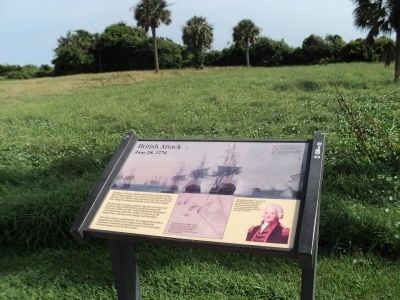
Confident of victory, British Admiral Peter Parker led his fleet of nine warships in an attack on the palmetto log fort, June 28, 1776. Parker’s ships anchored only 400 yards from here, firing thundering broadsides in the nine-hour battle. The . . . — — Map (db m67389) HM
On Jasper Boulevard (State Highway 703) at Middle Street, on the right when traveling east on Jasper Boulevard.
British Attack at Breach InletIn 1776, a force of British Army regulars attempted to cross Breach Inlet in an effort to capture Fort Sullivan (Fort Moultrie). Their advance was thwarted and many British lives lost when their boats were caught in . . . — — Map (db m31100) HM
On Jasper Boulevard (State Highway 703), on the right when traveling east.
British and American forces struggled for control of this strategic city throughout America’s quest for independence. The Revolution in South Carolina began in 1775 when Patriot leaders overthrew the British colonial government in Charles Town. The . . . — — Map (db m67282) HM
Almost four years after their defeat at the palmetto log fort in 1776, the British returned to Charleston with a larger force, new tactics, and respect for Fort Moultrie. The British did not repeat their earlier mistakes. A British fleet of 96 . . . — — Map (db m67396) HM
On Middle Street at Station 18 Street, on the left when traveling west on Middle Street.
Military reservation Named in Honor of Col. William Moultrie who commanded Fort Sullivan (now Fort Moultrie) comprising the 2nd South Carolina Regiment of infantry and a detachment of the 4th South Carolina Regiment (Artillery) during the . . . — — Map (db m19125) HM
On Middle Street, on the right when traveling west.
Down the walk on your left is the grave of General William Moultrie, a citizen of Charleston, who on June 28, 1776 led American troops in the defense of the city. From the walls of the unfinished palmetto log fort on Sullivan's Island he won a . . . — — Map (db m31915) HM
On Jasper Boulevard (State Highway 703), on the right when traveling east.
The American victory at Breach Inlet came at great risk and sacrifice. Thomson’s rangers, other state troops, militia, and Indians from South Carolina were joined by soldiers from North Carolina and Virginia. They all hurried to defend Sullivan’s . . . — — Map (db m67304) HM
Near Middle Street west of Station 13 Street, on the right when traveling west.
Major General William Moultrie
1730 - 1805
Commander of
Second South Carolina Regiment
During the Battle of Sullivan's Island
June 28, 1776
When offered inducements by Lord Charles
Montagu to desert the American cause,
General . . . — — Map (db m108527)
In 1776 South Carolinians prepared for a British invasion by building a fort on this site. This key position on Sullivans Island, beside the main ship channel, protected the entrance to Charleston Harbor. The fort was designed as a 500-foot square . . . — — Map (db m67399) HM
Near Middle Street west of Station 13 Street, on the left when traveling west.
The two cannon in front of you are reproductions cast in 1976 by the National Park Service for the American Bicentennial Celebration, and placed here to generally represent the location of the palmetto log fort built in anticipation of a British . . . — — Map (db m108528) HM
On Jasper Boulevard (State Highway 703), on the right when traveling east.
Commemorating the 1776 defense of Charles Town against the British army by American Patriots under Colonel William “Danger” Thompson. Dedicated in 2011 by Friends of Danger www.thomsonpark.org — — Map (db m68336) HM
On Jasper Boulevard (State Highway 703), on the right when traveling east.
Ten days of skirmishing on beaches, creeks, and marshes climaxed on June 28, 1776 with the British attempt to cross Breach Inlet during the bombardment of Fort Sullivan. Colonel William “Danger” Thompson and 780 American Patriots had . . . — — Map (db m67272) HM
On Middle Street, on the right when traveling west.
A Memorial to the Valor of
Sergeant Jasper
who at Fort Moultrie on June
28, 1776 gallantly rescued his
regimental flag during heavy
cannonading by the British
Fleet under Sir Peter Parker
———————
Erected by the North Carolina . . . — — Map (db m224048) HM
“Huzzah for Liberty!”-The hour is 3 o’clock, October 7th, 1780. Atop the ridge are 1100 British-Americans under Major Patrick Ferguson.
Surrounding the mountain are about as many American Patriots gathered from far and near. Within the . . . — — Map (db m62103) HM
On Battleground Drive (State Highway 216) at Rock House Road, on the left when traveling south on Battleground Drive.
[Front]:
Col. Frederick Hambright (1727-1817), a prominent militia officer of the American Revolution, lived his last 25 years in a house which stood 200 yds. NE. Hambright, born in Germany, emigrated to America as a boy, and settled in . . . — — Map (db m28236) HM
On Battleground Road (Highway S46-705), on the left when traveling east.
James Williams at Kings Mountain
James Williams was born in Virginia in 1740. He married Mary Wallace in 1762, and the couple had eight children. The Williams family moved south to Caswell County, N.C., then to present day Laurens County, . . . — — Map (db m206695) HM
On Ashley River Road (South Carolina Route 61) 0.1 miles south of Plainview Road, on the right when traveling north.
On March 22, 1780, British and Hessian troops nearing Charleston were met by Patriot cannon fire near St. Andrew's Parish Church.
They advanced on the church from the opposite side of Church Creek after reports that a Patriot detachment of 150 . . . — — Map (db m242464) HM
Near Chesnee Highway (State Highway 11) at Battlefield Road (State Highway 110).
In 1849, journalist-historian Benson Lossing traveled to the Scruggs farm seeking information about the Cowpens battle. Using the house as a point of reference, he located fields "within a quarter mile of the Scruggs" where the battle raged more . . . — — Map (db m32276) HM
Near the end of the battle, as the Americans swept forward, two Continental officers sought to capture the enemy's light 3-pounder "grasshopper" cannons. Captain Anderson of Maryland won the race when he used his spontoon to vault forward onto one . . . — — Map (db m13029) HM
On Cowpens Road south of Piedmont Road, on the left when traveling north.
After victory at Cowpens, American commander, General Daniel Morgan marches his army off this field to the north and crossed the Broad River. In North Carolina, Morgan dismissed the militia.
Many of the heroes of Cowpens helped build the . . . — — Map (db m34739) HM
South Inscription:
The Congress of the United States has caused this Monument to be erected on the site of the Battle of Cowpens as a testimonial to the valor and in appreciation of the services of the American Troops on this field in . . . — — Map (db m11186) HM
After firing twice, the militia retreated behind the
Continentals who were awaiting the British advance in this area. British reinforcements, Fraser's 71st Highlanders, threatened the Continentals' right flank. Lt. Col. Howard ordered his right . . . — — Map (db m13031) HM
Near Battleground Tour Road (Route 11), on the right when traveling east.
On this field, the Continentals blunted the British advance, then charged with bayonets flashing. Cavalry hit the left and right of the 71st. The militia reformed and surged against the right and left. British troops found themselves overwhelmed . . . — — Map (db m13030) HM
Today Tarleton's force would be called a combined arms task force. It contained all the elements to conduct a quick movement and "engage an enemy." Ranks of redcoated fusiliers, regulars, and raw recruits of the 7th Regiment formed in this immediate . . . — — Map (db m13423) HM
The view seen beyond was a frontier pasturing ground, known locally as the Cow Pens. The name came from the custom of wintering cattle in the lush area around Thicketty Mountain.
General Daniel Morgan chose this ground for its tactical . . . — — Map (db m126716) HM
Near Battleground Tour Road, 0.8 miles east of McGinnis Road, on the right when traveling east.
The land you are standing on has not always been protected by the National Park Service. For 200 years after the battle, homes, farms, and other businesses occupied the 842 acres that make up Cowpens National Battlefield.
Although Congress . . . — — Map (db m108656) HM
Near New Pleasant Road (State Highway S-11-58) at State Highway S-11-22, on the right when traveling north.
Richard Scruggs II bought 100 acres adjacent to Cowpens battlefield after the South Carolina General Assembly opened vacant lands for sale. Around 1811 he built a log cabin, probably with a split log roof and dirt floor. The family sheared wool, . . . — — Map (db m108653) HM
The British soldiers arrived at the Cow Pens about dawn. The right flank of the British army formed in this general area with the rest of the troops stretching across the Green River Road. Ahead, in the distance, Morgan's army awaited. — — Map (db m11356) HM
The American second line of defense stood in position here. About sunrise,the British appeared. The militia, though not trained to stand against massed British bayonets, fought well and shot with deadly effect. "At first it was pop, pop, pop . . . — — Map (db m77693) HM
Morgan's army came from many states-the two Carolinas, Delaware, Georgia, Maryland, and Virginia. They were joined by the militia, some of whom had helped destroy the British army of loyalist Americans under Ferguson at Kings Mountain. They . . . — — Map (db m13035) HM
On Battleground Tour Road (Route 11), on the right when traveling east. Reported missing.
General Morgan's army secured a great victory on the field before you: "Our loss was inconsiderable, not having more than twelve killed and sixty wounded. The enemy's loss was 10 commissioned officers and over 100 rank and file killed and 200 . . . — — Map (db m13034) HM
On Battleground Tour Road (Route 11), on the right when traveling east.
General Morgan's army secured a great victory on the field before you: "Our loss was inconsiderable, not having more than twelve killed and sixty wounded. The enemy's loss was 10 commissioned officers and over 100 rank and file killed and 200 . . . — — Map (db m88623) HM
On Battlefield Tour Road, 0.1 miles east of State Highway S-11-22, on the right when traveling north.
The Green River Road, which evolved from an Indian trail to a colonial trade route, played a fundamental role in the Revolutionary War battles that led to America's victory at Yorktown, Virginia.
On the evening of October 6, 1780, while on . . . — — Map (db m108657) HM
The sharpshooters at the skirmish line waited until Tarleton's army got within shooting distance. Their orders were to slow Tarleton's advance with well-aimed rifle fire and then fall back to the militia second line. As the British came within . . . — — Map (db m13065) HM
After firing as ordered, the American skirmishers melted back to the second line of defense.
Seeing this, the British troops moved forward at quickstep, raising a great shout as they advanced. — — Map (db m13028) HM
Near Chesnee Highway (State Highway 11). Reported unreadable.
"Sir-you are appointed to the command of a corps of Light Infantry, a detachment of Militia, and Lt. Col. Washington's Regiment of Light Dragoons...The object of this detachment is to give protection to that part of the country and spirit up . . . — — Map (db m13061) HM
Near Chesnee Highway (Route 11), on the right when traveling east.
Nearby, retreating British officers of the 17th Light Dragoons, clashed with pursuing American horsemen led by Lt. Col. William Washington. He quickly outpaced his troops, broke his weapon at the hilt when he got into a sword fight with a British . . . — — Map (db m13025) HM
On Chesnee Highway (State Highway 11) at Hayes Road, on the left when traveling west on Chesnee Highway.
In the winter of 1780, General Daniel Morgan moved a veteran force of American Continentals and militia into the area west of the Broad River in modern-day Spartanburg and Cherokee Counties. To counter this threat, British Commander Lord Cornwallis . . . — — Map (db m108659) HM
On this field on January 17, 1781, Daniel Morgan led his army to a brilliant victory over Banastre Tarleton's force of British regulars. One of only a few successful double envelopments in history, this battle is recognized by historians as one . . . — — Map (db m126715) HM
British commander, Lt. Col. Banastre Tarleton, ordered a detachment of cavalry forward to scatter the American skirmishers. The green-uniformed British Legion - Americans loyal to the king - awaited the order to advance. — — Map (db m11357) HM
The open forests proved well-suited for cavalry action. Fast-moving, hard-hitting mounted troops called Light Dragoons bolstered the 18th century infantry.
At least seventy South Carolina and Georgia mounted militiamen, armed with pistols and . . . — — Map (db m13063) HM
This line consisted of Continentals from Maryland and Delaware as well as militia from Virginia and North Carolina. Seasoned veterans under Lt. Col. John Eager Howard of Maryland, they had served at least one year and were Morgan's most reliable . . . — — Map (db m13064) HM
The Overmountain Victory National Historic Trail preserves and commemorates the route of Patriot militia during the 1780 Kings Mountain campaign.
During that historic event, on October 6, 1780, American forces stopped here at the Cow Pens to rest . . . — — Map (db m108660) HM
On Chesnee Highway (State Highway 11) at Hayes Road, on the left when traveling west on Chesnee Highway.
The Revolution in the South
After the war in the North came to a stalemate, British commanders decided take the war to the South where there was thought to be an abundance of Loyalist (Americans in favor of British rule) support.
When the . . . — — Map (db m108661) HM
This Monument was erected by
The Washington Light Infantry
Of Charleston S.C.
L.M. Hatch. Capt
April. 1856
Cowpens Chapter D.A.R.
1936 — — Map (db m13385) HM
Near Piedmont Road, 0.4 miles south of Chesnee Highway (South Carolina Route 11).
The Washington Light Infantry of Charleston, South Carolina, erected this monument in 1856 near the final stages of the Battle of Cowpens to commemorate the important American victory here. Though the years have changed much of the monument's . . . — — Map (db m138554) HM
On Union Highway (State Highway 18) south of Round Tree Road.
This plantation, 1.5 mi. S. near Thicketty Creek, was settled about 1767 by John Nuckolls, Sr. (1732-1780), a native of Virginia. During the American Revolution, as the war in the backcountry became a vicious civil war, the plantation became . . . — — Map (db m39046) HM
On Great Falls Highway (State Highway 97) at Chester Avenue (State Highway 99), on the left when traveling east on Great Falls Highway.
The skirmish which took place here at Alexander's Old Fields, now Beckhamville, on June 6, 1780, was the first victory for S.C. Patriots after the fall of Charleston. A band of Whigs under the command of Captain John McClure attacked and routed . . . — — Map (db m13688) HM
On State Highway 97 at Old Catholic Church Road, on the right when traveling east on State Highway 97.
Divergent Presbyterian groups held services in this area as early as 1759. Rev. William Richardson, active in the area, is credited with unifying and naming them in 1770. The cemetery contains many graves of Revolutionary and Confederate . . . — — Map (db m13687) HM
Near Old Catholic Church Road (County Route 355) 0.9 miles south of Great Falls Highway (South Carolina Route 97), on the right when traveling south.
Rev William Martin 1716-1806 •
Col. John Nixon 1780 Capt. John Steel 1750-1810 •
Capt. Hugh Knox 1755-1821 Capt. Benj. Land 1780 •
Robert Archer 1748-1818 John Corder •
William Anderson 1744-1780 John Lee 1760 •
John Bailey David McCalla . . . — — Map (db m245568) WM
Near Steele Village Road at Fishing Creek Church Road.
SC Militia under General Thomas Sumter
Justice of the Peace
Tax Inquirer & Collector
Member Committee of Elections
Member, 1st & 2nd Provincial Congresses
Member, General Assemblies — — Map (db m13767) HM
Near Steele Village Road at Fishing Creek Church Road.
[Front Side]
In Memory of
The Reverend John Simpson
1740-1808
Wife
Mary Remer
1743-1812
Minister
Educator
Soldier
Patriot
Married 1765- New Jersey
Graduated Princeton College with high honors 1768
Studied . . . — — Map (db m13799) HM
On State Highway 9 at Morrison Road, on the right when traveling east on State Highway 9.
Two miles south, at Cedar Shoals on the south side of Fishing Creek, was the home of John Gaston, Esq., Justice of the Peace under both the Royal and State governments. Though advanced in years, he was the leading spirit in arousing resistance to . . . — — Map (db m13758) HM
On Catawba River Road (U.S. 21) at Landsford Road (State Highway 843), on the right when traveling north on Catawba River Road.
[Front Side]
Located about 4 mi. E., this ford, an early Indian crossing, was probably named for Thomas Land who received a nearby land grant from the Crown in 1775. Used by Patriot and British armies during the American Revolution. Later . . . — — Map (db m13757) HM
On U.S. 21 at Waterview Drive, on the right when traveling north on U.S. 21.
At this site on August 18, 1780 General Thomas Sumter camped with captured booty and 800 men. He was surprised and defeated by Lt. Col. Tarleton and 160 soldiers. The disaster followed only two days General Gate's defeat by Lord Cornwallis at . . . — — Map (db m13690) HM
On Catawba Road (State Highway S-20-20) 0.4 miles east of Peay Ridge Road (State Highway S20-268), on the right when traveling east.
Here in 1780-81
was the British post
Rocky Mount
Unsuccessfully
attacked by
Gen. Sumter
Aug. 1, 1780.
Col. Andrew Neel
and 7 privates killed. — — Map (db m228191) HM WM
On West End Road (State Highway 215) 0.5 miles west of Store Road, on the left when traveling east.
On the east side of Broad River by an old Indian fish dam, General Thomas Sumter's camp was attacked before dawn on November 9, 1780 by the British 63rd Regiment and a detachment of the Legion, led by Major James Wemyss. The American campfires . . . — — Map (db m13685) HM
On U.S. 52 at Howard Lane, on the right when traveling south on U.S. 52.
Cash Homesite
About 100 yards east of here was the home of General Ellerbe Boggan Crawford Cash, widely known for his 1880 duel with challenger Colonel William M. Shannon, whom he killed. Subsequently, all officers of the state and members of . . . — — Map (db m28267) HM
On Church Street at Front Street, on the left when traveling west on Church Street.
Encamped at Cheraw Hills in the summer of 1780 during the American Revolutionary War.
The Fraser Highlanders were recruited in Scotland in 1775 by their Clan Chief Simon Fraser, Master of Lovat, to serve in the army of King George III. They . . . — — Map (db m54803) HM
On East Main Street at Green Street, on the right when traveling west on East Main Street.
[Front]:
This house, the oldest in Chesterfield, was built ca. 1798 for John Craig (1755-1839), veteran of the American Revolution, merchant and miller, and county official. Craig’s father Hugh moved his family from Ireland to Virginia in . . . — — Map (db m28329) HM
On North Brewington Road (State Highway 14-50) 1.7 miles north of U.S. 301, on the right when traveling north.
On the night of October 25, 1780, Col. Francis Marion with 150 men surprised and completely routed 200 Torries under Col. Samuel Tynes near here. Marion's forces suffered no casualties. With the dispersion of Tynes's troops, Lord Cornwallis became . . . — — Map (db m227712) HM
On Patriots Road (State Highway 14-410) near Lesesne Drive (State Highway 14-480), on the right when traveling west.
During Francis Marion's 1781 campaign to drive the British from the Pee Dee, he and his men clashed near here in March with British and Tory forces numbering more than 500 men. During the Wyboo skirmish a Marion private, Gavin James, single-handedly . . . — — Map (db m24530) HM
Near Sunset Drive (U.S. 301) at South Boundary Street, on the right when traveling east.
William Dobein James, who rode with General Francis Marion during the Southern Campaign of the American Revolution, wrote in 1821 about L/C Tarleton following Marion "...as he (Tarleton) says, 'for seven hours, through swamps and defiles.' In fact . . . — — Map (db m161310) HM
On North Brooks Street (US 301 / 521) near West Rigby Street, on the left when traveling north.
During the American Revolution, December 1780, over 750 recently arrived British fusiliers were marching from Nelson’s Ferry on the Santee River. Major McLeroth’s British troops from Moncks Corner joined them as an escort to Camden. General Marion’s . . . — — Map (db m24370) HM
On Bozard Street east of South Mill Street (South Carolina Highway 260), on the right when traveling east.
During the American Revolution, the Bridges Campaign began March 6, 1781, with the Battle of Wyboo Swamp. Colonel Watson and British troops from Fort Watson were sent to crush General Marion. Marion’s Militia challenged them on the ¼ mile causeway . . . — — Map (db m227902) HM
On South Mill Street near Sunset Drive (U.S. 301), on the right when traveling south.
During the American Revolution, the militia like Marion's Brigade was totally dependent on a man with a horse and a gun who tended his farm and responded to Marion's call to arms. Marion rides this horse before battle at Black Mingo. Marion and . . . — — Map (db m24092) HM
On North Mill Street at Rigby Street, on the left when traveling south on North Mill Street.
During the American Revolution, 1780, General Marion and the men of his Brigade pushed back the British forces in the Black and Santee River Basins. It is unlikely that they thought they would be remembered by future generations. It may be that . . . — — Map (db m49051) HM
On South Mill Street (State Highway SC260) at W. Hospital Street, on the left when traveling north on South Mill Street.
During the American Revolution, General Marion and his Militia needed help from local farmers for food, horses and medical care for wounds and diseases. Those shot or sick were left at the mercy of comrades and sympathy of Patriots. Medical care was . . . — — Map (db m93817) HM
On North Brooks Street (U.S. 301) north of West Boyce Street (South Carolina Highway 261), on the left when traveling north.
Chartered by acts of the General Assembly beginning March 8, 1741 with title vested successively in Joseph Murray • Theodore Gaillard • James Hunter, Trustee • Adam McDonald • Theodore Gourdin and William Staggers.
Upon the death of Staggers in . . . — — Map (db m227893) HM
On US 301 & US 521, on the left when traveling north.
On the night of November 7, 1780, Lt. Colonel Banastre Tarleton and his Green Dragoons—together with Harrison’s Provincials, a large unit of Tories from the area between the upper Santee and Wateree Rivers—camped at the plantation of the late . . . — — Map (db m51985) HM
After the American Revolution, General Marion’s militiamen re-built his home. Francis Marion, at age 53, married Mary Esther Videau, April 20, 1786. They lived at Pond Bluff, on the south edge of the Santee Swamp and raised pineland cattle. With . . . — — Map (db m43156) HM
On South Boundary Street at West Boyce Street (South Carolina Highway 261), on the right when traveling north on South Boundary Street.
During the American Revolution, on Nov. 8, 1780, General Francis Marion and his brigade lured British Colonel Tarleton and his Green Dragoons about 26 miles from Jack's Creek through the swamps to Ox Swamp, less than 1 mile east of here. After . . . — — Map (db m227852) HM
On North Brooks Street (U.S. 301/521) near Rigby Street, on the right when traveling south.
During the American Revolution, after the fall of Charleston in 1780, Francis Marion burst forth to lead the Williamsburg militia. He was the senior Regimental Continental Officer not captured or paroled. He recruited patriots, ambushed the British . . . — — Map (db m23987) HM
On Patriot Road (State Highway 14-410) at Wyboo Road on Patriot Road.
In March 1781, Lord Francis Hastings Rawdon, the British commanding officer in Charleston, designed a two-pronged assault against the forces of General Francis Marion. From Camden, Col. Welbore Ellis Doyle and the Volunteers of Ireland moved east . . . — — Map (db m51986) HM
On Paxville Highway (State Highway 261) at U.S. 15, on the right when traveling east on Paxville Highway.
During the American Revolution, November 1780, Colonel Tarleton with his Green Dragoons hunted General Marion. Tarleton encamped at the late General Richardson’s home. Marion was warned by the widow's son and quickly withdrew to the east of Jack's . . . — — Map (db m23958) HM
On Old River Road (State Highway 14-76) 1 mile south of Governor Richardson Road, on the right when traveling south. Reported missing.
(front)
Encounter at Halfway Swamp
On December 12, 1780, according to tradition, British Maj. Robert McLeroth was surprised near here by Gen. Francis Marion. The British first agreed to a staged combat with twenty men on each side, . . . — — Map (db m43328) HM
On Old River Road (State Highway 14-76) 1 mile south of Governor Richardson Road, on the right when traveling south.
(side 1)
Encounter at Halfway Swamp
On December 12, 1780, according to tradition, British Maj. Robert McLeroth was surprised near here by Gen. Francis Marion. The British first agreed to a staged combat with twenty men on each . . . — — Map (db m227896) HM
On Old River Road at Elliots Landing Road, on the right when traveling south on Old River Road.
In December 1781, Maj. Robert McLeroth and the 64th Regiment were conducting newly-arrived British army recruits of the Royal Fusiliers from Charleston to the High Hills of Santee. Learning of McLeroth’s movement, Col. Francis Marion led some 700 . . . — — Map (db m227715) HM
23 April 1781
American Forces
led by
Brig. Gen. Francis Marion
"The Swamp Fox"
South Carolina Malitia -
Commander [Marion picture included]
LTC Henry "Lighthorse Harry" Lee
Lee's Legion
British Forces
led by . . . — — Map (db m24418) HM
On South Church Street (U.S. 15) near Main Street (U.S. 301), on the right when traveling north.
During the American Revolution, General Marion’s Brigade eluded the British invaders. Marion’s Militia slipped through swamps, trees and grasslands, enticing the British to follow and search along the Santee.
In November 1780, the British sent . . . — — Map (db m93772) HM
On Fort Watson Road (State Highway 14-803) 1 mile west of St Paul Road (U.S. 15/301), on the left when traveling west.
One of the chain of British posts in South Carolina. Located on this Indian Mound. Besieged April 15-23, 1781 by use of Maham's tower, Francis Marion forced the British to surrender and secured for his men badly needed ammunition and supplies. — — Map (db m227711) HM
On Fort Watson Road (State Highway 14-803), on the left when traveling west.
The first post in S.C. retaken from the British, the stockade fort on this old Indian mound had controlled the road from Charleston to Camden as well as the Santee River. On April 15, 1781, Gen. Francis Marion and Lt. Col. Henry Lee encircled it . . . — — Map (db m94074) HM
On St. Paul Road (U.S. 301/15), on the right when traveling north.
Assigned to hold all of eastern South Carolina but with only a small force at his disposal, Col. John Watson needed to build a fort to protect the vital transportation corridor between Charleston and Camden, the British inland headquarters. The spot . . . — — Map (db m51477) HM
On Cantey Street, on the right when traveling east.
During the American Revolution, August 1780, General Francis Marion was ordered by General Gates to roam the Santee burning boats. Being successfully engaged in this task, he learned of Gates’ defeat at Camden. This Patriot left his family at . . . — — Map (db m24130) HM
On Fort Watson Road (State Highway 14-803), in the median.
This land...
inhabited by Native Americans.
This site, once occupied by Native Americans, was a major ceremonial
center for the surrounding area. The Santee Indian mound is typical of
pyramidal, flat-topped mounds that are widely . . . — — Map (db m30132) HM
On West Main Street (U.S. 301) at South Dukes Street, on the right when traveling south on West Main Street.
During the American Revolution, Colonel Lee
and his Legion joined General Marion's Brigade
along the Santee River. They laid seige to British
held Fort Watson on top of Santee Indian Mound.
Major Maham's idea was to build a tower . . . — — Map (db m23704) HM
Sacred to the memory of Brig. Gen.Francis Marion who departed this life, on the 27th of February, 1795, in the sixty-third year of his age; deeply regretted by all his fellow citizens History will record his worth, and rising generations . . . — — Map (db m150320) HM
During the American Revolution, after the fall of Charles Town in 1780, General Francis Marion’s militia frequently crossed the Santee swamps and appeared at every turn near Jack's Creek and the Santee River with his men who were red, white and . . . — — Map (db m24023) HM
On West Main Street (U.S. 301) near South Dukes Street, on the right when traveling south.
During the American Revolution, travel was slow and hard work. Wagons needed to stop often since wooden axles and wooden wheels required grease and maintenance. Marion’s militia was documented as travelling fifty miles through the swamps at night on . . . — — Map (db m24183) HM
On Calvert Street (State Highway 14-119) west of Main Street (U.S. 301), on the right when traveling west.
During the American Revolution, a few miles south of Turbeville, General Marion and his militia routed the British. General Marion learned Colonel Tynes with over ninety troops was camped at the edge of Tearcoat Swamp. On Oct. 25, 1780, Marion moved . . . — — Map (db m227708) HM
640 entries matched your criteria. Entries 101 through 200 are listed above. ⊲ Previous 100 — Next 100 ⊳