On Runnymeade Road (County Route 26) at Soldier Drive, on the right when traveling west on Runnymeade Road.
300 yards west is one of the oldest Episcopal churches in West Virginia. Built in 1740 by Morgan Morgan. Five Revolutionary soldiers buried in church yard. Used as a barracks during war between the states. — — Map (db m134064) HM
On Winchester Pike (U.S. 11) north of Old Mill Road, on the right when traveling north. Reported missing.
Morgan Morgan, a native of Wales, established his home at Bunker Hill before 1732, and was leader in Eastern Panhandle’s early development. His sons gave name to Morgantown, and fought in Indian and Revolutionary Wars. — — Map (db m1176) HM
On Winchester Pike (U.S. 11) south of Hatchery Road (County Route 11/8).
Named for Gen. William Darke, veteran of the Revolution and the Indian wars. He saved the remnants of St. Clair’s army from massacre in 1791 when badly defeated by the Miami Indians. His son, Capt. Joseph Darke, lost his life. — — Map (db m167181) HM
On Martinsburg Road or Hedgesville Road (West Virginia Route 9) west of Rustic Tavern Road, on the right when traveling west.
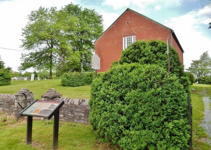
Morgan County. Formed, 1820, from Berkeley and Hampshire. Named for Gen. Daniel Morgan of the Revolutionary Army. Many of his renowned “Riflemen” were from the Eastern Panhandle, where he once lived. Famed Berkeley Springs here.
Berkeley . . . — — Map (db m1112) HM
On Route 9 Bike Path south of Short Road (County Route 9/19), on the right when traveling north.
Stone House Mansion, predominantly Georgian in style, was constructed in 1757, and is one of the oldest stone structures in Berkeley County. The property is listed in the National Register of Historic Places for its association with the Hite vs. . . . — — Map (db m167518) HM
On East John Street east of South Water Street, on the right when traveling west.
This structure was constructed of native limestone by Revolutionary War General Adam Stephen, founder of Martinsburg. Restored by the City of Martinsburg and the Adam Stephen Memorial Association, Inc. — — Map (db m132404) HM
On East John Street east of South Water Street, on the right when traveling west.
Adam Stephen (1720-1791) had a close acquaintance with George Washington through their association with Lord Fairfax and from their military involvements from the French & Indian War through the American Revolution. Stephen was present with . . . — — Map (db m167507) HM
On Queen Street (U.S. 11) at King Street (U.S. 11), on the right when traveling north on Queen Street.
The colonial village of Martinsburg was established by law enacted by the General Assemply of the Commonwealth of Virginia on October 21, 1778. Martinsburg’s founder was General Adam Stephen, a noted soldier of the American Revolutionary War. . . . — — Map (db m167514) HM
Here was home of General Adam Stephen, founder of Martinsburg and county's first sheriff. Was famous as fighter in French and Indian Wars, and as major general in the American Revolutionary War. — — Map (db m12786) HM
On South Queen Street (West Virginia Route 9) north of Bulldog Boulevard, on the left when traveling north.
He was commander of a division in the Revolution. Voted for the adoption of the federal constitution while a member of the Virginia Assembly. Granted 130 acres of land for the site of Martinsburg and was the first sheriff of Berkeley County. — — Map (db m132409) HM
On King Street (U.S. 11) near North Maple Avenue, on the left when traveling east.
Martinsburg. Established, 1778, by Gen. Adam Stephen. Named for Col. Thomas Martin, nephew of Lord Fairfax. Home of Admiral C.K. Stribling and Admiral Charles Boarman. In Jackson’s raid, 1861, captured B&O locomotives were drawn by horses to . . . — — Map (db m1976) HM
On Main Street west of 3rd Street, on the right when traveling west.
Honoring Revolutionary War Soldiers and Patriots buried in Braxton County.
Andrew Skidmore, 1750-1827 • Charles Francis Boggs Jr., 1754-1837 • Jacob Fisher 1763-1846 • Peter Shields, 1755-1832 • John Dobbins 1747-1833 • Patrick Murphy, . . . — — Map (db m179591) WM
On West Virginia Route 2 at Park Avenue, on the right when traveling south on State Route 2.
Near here stood Beech Bottom Fort, which was with Fort Pitt and Fort Henry in the group of posts guarding the western borders during the Revolution and its attendant Indian wars. Troops from Fort Pitt helped garrison this important fort. — — Map (db m54915) HM
On 8th Street north of 5th Avenue (U.S. 60), on the left when traveling north.
This memorial dedicated to the memory of Revolutionary War Soldiers buried in Cabell County
James Cox •
Adam Cron •
Daniel Davis •
John Everett •
James Gillingwater •
Thomas Laidley •
Charles Love •
John McComas •
Lerose Merritt . . . — — Map (db m208541) HM WM
Plaque One
Abraham Vandal
1758-1848
* Born in Dutchess, NY
* Soldier in the American Revolutionary War 1776-1781
* Married Mary Dillon 1780
* Father of Eight Children
* Early Fayetteville Settler
* In 1812 Abraham . . . — — Map (db m55816) HM
On North Court Street (West Virginia Route 16), on the left when traveling east.
Front Plaque
French Statesman
Friend of the American Revolution
“...The new County so to be formed be called Lafayette or Fayette County to perpetuate a remembrance of his virtues and philanthropy through future ages of our . . . — — Map (db m55817) HM
On Midland Trail W (U.S. 60) at Old State 12/Alta Mountain Road (County Route 60/38) on Midland Trail W. Reported missing.
Fort Donnally Built by Andrew Donnally a few miles north about 1771. Attack on this fort by 200 Indians in 1778 was second most important frontier engagement in the State. The fort was relieved by force under Colonel John Stuart.
Border . . . — — Map (db m55818) HM
Enslaved African, noted for bravery in defense of Fort Donnally during Shawnee attack May 29, 1778. He was granted his freedom by James Rodgers in 1801. Land granted to other defenders; his 1795 pension petition, supported locally, denied. . . . — — Map (db m21737) HM
Near Northwestern Turnpike (U.S. 50) just west of School Street, on the right when traveling west.
This cemetery is centered around what is known as the Romney Indian Mound. Indian Mound Cemetery is also the site of the First Confederate Memorial, Parsons Bell Tower, and re-interments from Romney's Old Presbyterian Cemetery. The cemetery is . . . — — Map (db m150650) HM
On West Virginia Route 28 at Buffalo Hollow Road on State Route 28.
Frontier outpost, Capt. William Forman (Foreman), in 1777, led a company from this county to the relief of Fort Henry at Wheeling. He, two sons, and others were killed in an ambush by Native Americans at the "Narrows" near Moundsville. — — Map (db m19357) HM
On West Virginia Route 2 at Ferndale Road (County Route 66/2), on the right when traveling north on State Route 2.
On This Spot. On September 18, 1781, Adam Poe and Andrew Poe while freeing white captives, engaged in combat with a war party of the Wyandott tribe and killed the sons of the Wyandott Chief. — — Map (db m39661) HM
On Cove Road at Main Street (West Virginia Route 2), on the right when traveling west on Cove Road.
East was Fort Holliday, built in 1776. During the Revolution it was a supply depot for the Continental Army. From it Col. Swearingen led troops with ammunition to relieve Fort Henry at Wheeling when attacked by Indians in 1777. — — Map (db m80384) HM
On West Virginia Route 259, 0.1 miles north of Howard's Lick River State Park Road (County Route 12), on the left when traveling south.
Howard's Lick
Howard's Lick, or Lee White Sulphur Springs, was once owned by Gen. Henry "Light Horse Harry" Lee of Revolutionary War fame. It was owned later by Charles Carter Lee, brother of the beloved Gen. Robert E. Lee.
Jackson Home . . . — — Map (db m50470) HM
On Main Street (U.S. 220), on the right when traveling south.
(Front): Near here, grave of Gen. Joseph Neville; officer in Revolution; member of conventions of 1775 and 1776. With Alexander McLean of Pennsylvania, he completed survey of the Mason and Dixon line in 1782. His son, Joseph, was a general in . . . — — Map (db m23213) HM
On West Main Street east of Sumner Street, on the right when traveling east.
Born along Devils Crk. in the Millstone Valley of New Jersey. Married
Prudence Izzard of Phil. in 1772. Came to Harrison Co. Va. in 1773 with wife
father, Obadiah, uncles John, Andrew, Amaziah and families. His survey
listed 400 acres in 1773 . . . — — Map (db m184966) HM
On West Main Street east of Sumner Street, on the right when traveling east.
Site of Hopewell Baptist Church and burial place of Daniel Davisson. Major in Revolution. Commander of Nutter Fort and High Sheriff of Harrison County, he donated land for county buildings and this cemetery in the year of 1790. — — Map (db m184812) HM
Near Enterprise-Bethlehem Road (County Road 19/28) 0.2 miles south of Laurel Run (County Road 19/27), on the right when traveling south.
In memory of
Jacob Bigler
Born 1752 - Died 1829
and
Elisha Griffith
Born 1751 - Died
American Soldiers
in the Revolutionary War
— — Map (db m177565) WM
On Enterprise Road (County Route 19/2) east of Bridgewater Drive, on the right when traveling east.
In the I.O.O.F. Cemetery on the east side of the West Fork River at Enterprise are graves of Jacob Bigler (1752 - 1829) and Elisha Griffith (1751 - 1843), veterans of Revolutionary War who later settled in Harrison County. The graves are marked by a . . . — — Map (db m177757) HM
On Main Street (West Virginia Route 20) north of Denver Avenue, on the right when traveling west.
Near blockhouse built by Thomas Harbert and others about 1775. This was the home of Col. Benjamin Robinson who was a soldier in the Revolution. He led a company at Brandywine and Germantown
and also saw Indian service. — — Map (db m177066) HM
On Buckhannon Pike (West Virginia Route 20) at Thomas Avenue, on the right when traveling south on Buckhannon Pike.
Built by Thomas Nutter in 1772 after settlement two years earlier. Nutter was a captain in the Revolutionary Army and is buried here. Refugees from Hacker's Creek settlements came here during the Indian raids of 1779. — — Map (db m161273) HM
On Washington Heritage Trail (West Virginia Route 51) near the Opequon Creek Bridge, on the right when traveling east. Reported missing.
Jefferson County. Formed, 1801, from Berkeley. Named for Thomas Jefferson. Home of Gens. Gates, Darke, and Charles Lee. Here four companies of Washington’s men organized. Shepherdstown was strongly urged as the seat of the National Capitol.
. . . — — Map (db m3449) HM
To the Glory of Patriotism
In memory of
Abraham Davenport
and his wife
Mary Simms.
Their seven sons were
soldiers of the
American Revolution
———————
Stephen, Abraham, John,
Marmaduke, . . . — — Map (db m103512) WM
On E. Washington Street (West Virginia Route 51), on the right when traveling east.
Grave of Robert Rutherford, member of committee which in 1775 replied to orders of Lord Dunmore for Virginians to join British army or be held as rebels. This defiance was a gauntlet hurled at Dunmore's feet. (1½ Mi. N. E.) — — Map (db m12624) HM
On E. Washington Street, on the right when traveling west.
Grave of Robert Rutherford, member of committee which in 1775 replied to orders of Lord Dunmore for Virginians to join British army or be held as rebels. This defiance was a gauntlet hurled at Dunmore's feet. (1½ Mi. NE) — — Map (db m12630) HM
On Summit Point Road (County Road 13) 0.2 miles west of McCormack Lane, on the right when traveling east.
1730 John and Isaac Van Meter, sons of Dutch immigrant Jobst Jansen Van Masteren, obtained grants for 40,000 acres in then Berkeley County, VA. from Virginia Lt. Gov. Gooch.
1731 Jost Hite, a German immigrant, purchased this land . . . — — Map (db m173642) HM
Revolutionary War Soldier
William Broadus
Born 1755
Died October 5, 1830
Lieutenant in the First Virginia Regiment
Commanded by Colonel George Gibson
Marker placed by
General Adam Stephen Chapter, NSSAR
and
Virginia Society, NSSAR . . . — — Map (db m103454) HM WM
On Bakerton Road at Morning Calm Lane on Bakerton Road.
In this cemetery are buried George Adam Moler (1714–1783) and his wife Eve. George Adam Moler came to American on Aug. 29, 1730 with his father Ludwig Mohler, settling first in Lancaster, Penn. He moved to this area around 1758. He received a land . . . — — Map (db m1962) HM
On Kearneysville-Virginia Line Road, 0.5 miles west of Leestown Pike, on the right when traveling west.
Home of General Charles Lee, built on land bought in 1774. Lee, colonel in British army, resigned his commission and joined the colonists after Battle of Lexington. On this estate, the U.S. Government maintains a fish hatchery. — — Map (db m12069) HM
On Kearneysville Rd. at Charles Town Road, on the left when traveling west on Kearneysville Rd..
Home of Gen. Horatio Gates, built on land bought, 1763. Gates, once a British officer, joined the Revolutionary Army, and was the leader of the Continentals in decisive victory over Gen. Burgoyne at Saratoga. (1/2 Mi. S. W.) — — Map (db m12068) HM
On Route 9 Bike Path, 0.7 miles north of Leetown Road (County Road 1), on the right when traveling south.
Traveller's Rest
Traveller's Rest is the site of a pre-Revolutionary War, 1½-story limestone dwelling and several log, wood frame, and masonry outbuildings. The property is listed in the National Register of Historic Places and . . . — — Map (db m150614) HM
On Flowing Springs Road (County Route 17) at County Route 17/2, on the right on Flowing Springs Road.
Within these grounds is the home of General William Darke (1736-1801), who served as officer in American Revolution and in St. Clair's 1791 expedition against Miami Indians in Ohio. He served as delegate to the Virginia Convention called 1788 to . . . — — Map (db m5347) HM
On Flowing Springs Road (County Route 17) at County Route 17/2, on the right when traveling south on Flowing Springs Road.
In this community resided William Darke, soldier-statesman, who began his career of selfless service to our nation in the French and Indian Wars. In 1777, he was captured at Germantown, Pa., remaining imprisoned aboard ship in New York harbor for . . . — — Map (db m158805) HM
On South King Street at East German Street (West Virginia Route 230), on the right when traveling north on South King Street.
In memory of the many patriots from Shepherdstown and vicinity who sacrificed their lives in the struggle for American Independence
1775 - 1783 — — Map (db m157758) WM
On East German Street (State Highway 45) at Princess Street (County Route 230), on the right when traveling west on East German Street.
In 1775, Shepherdstown (formerly known as Mecklenburg) was asked to furnish one company (about 100 men) to assist patriots fighting the British around Boston. In July, the company marched in high spirits down German Street with the entire town . . . — — Map (db m4851) HM
On North King Street (West Virginia Route 480) 0.1 miles east of Shepherd Grade Road, on the right when traveling east.
Jefferson County. Formed in 1801 from Berkeley. Named for Thomas Jefferson. Home of Generals Gates, Darke, and Charles Lee. Here four companies of Washington's men organized. Shepherdstown was strongly urged as the seat of the National . . . — — Map (db m167398) HM
On German Street (West Virginia Route 17/1) east of Mill Street, on the left when traveling east.
Within these walls lie the following Revolutionary War Soldiers and Patriots
Michael Entler • John Adam Link, Jr. • Philip Entler, Sr. • Andrew Ronemous • Philip Entler, Jr. • Lewis Ronemous< • Daniel Foulks • Philip Sheetz — — Map (db m103674) WM
On North Church Street (County Road 480/1) just north of Old Queen Alley, on the right when traveling north.
This Old English/Episcopal Cemetery contains the graves of these Revolutionary War soldiers: Maj. Henry Bedinger, Anthony Kerney, Lt. Daniel Bedinger, James Kerney Sr., William Morgan Jr., William Lemen, Caleb Levick, Robert Tabb, and the . . . — — Map (db m157759) HM
On German Street (West Virginia Route 17/1) east of Mill Street, on the right when traveling east.
Within these walls lie the following Revolutionary War Soldiers and Patriots:
Henry Cookus • John Hoffman • Michael Cookus • Nicholas Schell • John Haines • Peter Seever • Jacob Haynes • Peter Staley • Lawrence Hensel • John Martin Walforth . . . — — Map (db m103672) WM
Near Kearneysville Pike (West Virginia Route 480) at Starkey's Landing, on the left when traveling south.
Near this site in July 1775, then part of Berkeley County , Va., two companies of riflemen, led by Captains Hugh Stephenson of Berkeley County and Daniel Morgan of Frederick County, Va. rallied prior to their 600-mile journey to join General George . . . — — Map (db m108818) HM
Near Kearneysville Pike (West Virginia Route 480).
Less than half mile eastward is the famous spring around which, from their rendezvous on lands of Morgan and Bedinger, July 17th, 1775 Captain Hugh Stephenson’s Company of Virginia Riflemen, 98 volunteers started on their bee-line march to Boston . . . — — Map (db m107687) HM
On S King Street (County Route 480/2) near W German Street, on the right when traveling south.
On 11 June 1775, the Second Continental Congress authorized the raising of ten companies of riflemen in Pennsylvania, Maryland, and Virginia to aid General George Washington at the British siege of Boston. The Berkeley County Committee of Safety . . . — — Map (db m123005) HM
On S Duke Street / Kearneysville Pike (West Virginia Route 480), on the left when traveling south. Reported missing.
Less than half mile eastward is the famous spring around which, from their rendezvous on lands of Morgan and Bedinger, July 17th, 1775 Captain Hugh Stephenson’s Company of Virginia Riflemen, 98 volunteers started on their bee-line march to Boston . . . — — Map (db m108819) HM
On East Dupont Avenue (U.S. 60), on the right when traveling south.
Revolutionary Soldier
Wounded at the Battle of Point Pleasant
Oct. 10th, 1774
and of his wife
1751 - Catharine Carroll - 1823 — — Map (db m164716) HM WM
Near Greenbrier Street (U.S. 60) at Quarrier Street, on the right when traveling north.
1716 Gov. Spotswood's Shenandoah Expedition
1730's Shenandoah Valley settlements
1750-1760's Carolina's-Georgia back country settled
1745-49 Ohio Valley land rivalries
1754-63 French and Indian War
1775-83 . . . — — Map (db m233308) HM
On Kanawha Boulevard at Brooks Street, on the left when traveling south on Kanawha Boulevard.
Saved by two historic rides for powder. Ann Bailey on horseback through wilderness to Lewisburg and return. Fleming Cobbs poled down Kanawha River to Point Pleasant and return.
This boulder is established to commemorate Clendennin's . . . — — Map (db m23013) HM
On Elk River Road (U.S. 119) close to Milton Street, on the left when traveling north.
Captain John Young Grave of Revolutionary War Vet. John Young (1760-1850) located in nearby Sand Run Cemetery. Noted soldier, Indian scout & trapper, he came to Kanawha Val., 1780s, named county trustee, 1794, and farmed 225 acres here. . . . — — Map (db m50412) HM
On Hackers Creek Road (County Route 7) 0.7 miles north of Berlin Road, on the right when traveling north.
John Hacker (1743-1824) erected his
pioneer cabin about one mile west
of here in 1769. He was the first
white settler in Lewis County, and
in the watershed of the creek which
bears his name. He served under
General George Rogers Clark in . . . — — Map (db m173833) HM
On Old Mill Road (County Route 1) 2.9 miles north of 2nd Street (U.S. 119), on the left when traveling north.
In the Butcher Cemetery are
the graves of many pioneer
settlers, dating back more
than 100 years. Here lies
Paulser Butcher. Of seven
Butcher brothers in the
Revolution with Washington,
four were killed in action. — — Map (db m173810) HM
Near Jackson Mill Road (County Route 10) 2.6 miles north of U.S. 19, on the right when traveling west.
Pioneer cabin built by Henry McWhorter a Revolutionary soldier, in 1793, at McWhorter's Mill, now Jane Lew and used as home, church, school, and postoffice, was moved to its present site and presented to the state by his descendants August 14, . . . — — Map (db m197580) HM
On Center Avenue (U.S. 19) at Bank Street, on the right when traveling north on Center Avenue.
Established, 1818, on farm of Henry Flesher, Revolutionary War veteran, first settler. He was attacked by Indians in 1784, but made his escape. Here is grave of Alexander Scott Withers, who told the story of "Border Warfare." — — Map (db m155500) HM
On Logan Boulevard (West Virginia Route 10) at Holland Lane and Main Street, on the left when traveling east on Logan Boulevard.
Here was home of Thomas Dunn English, mayor, 1852 to 1857, and author of "Ben Bolt". Aracoma, daughter of Cornstalk and the wife of Bolling Baker, was killed in 1780 attack by settler, and is buried here. — — Map (db m49917) HM
On Industrial Park Road (County Route 58) 0.2 miles north of Vankirk Drive, on the right when traveling north.
Captain Booth migrated from the
valley of Virginia to this valley
in 1768-and founded the first
settlement here in 1772.
He was fired upon and killed by
a party of Shawnee Indians on
June 16th 1778, at a point on the
near shore of the . . . — — Map (db m175795) HM
On Overfort Lane east of Pricketts Fort Road (County Road 72), on the right when traveling east.
In memory of
Revolutionary War soldier and patriot
Colonel Zackquill Morgan
Born c. 1735 in Orange Co., VA
Died January 1, 1795 in Monongalia, VA — — Map (db m202524) HM WM
Near Overfort Lane east of Pricketts Fort Road (County Route 72), on the right when traveling north.
Here lies buried
Colonel Zackeill Morgan
One of the earliest settlers of the old Monongalia County
Soldier of the Revolution
Founder of
Morgantown, (VA.) West Virginia, (1785)
Born (C) 1735 in Frederick County Virginia . . . — — Map (db m173501) HM
On 3rd Street (West Virginia Route 310) at Virginia Avenue, on the left when traveling south on 3rd Street.
David Morgan (1721–1813). Son of Col. Morgan Morgan. Surveyed with Washington for Fairfax Stone; explored with Boone & Gist. Settled here in 1771. Surveyed Pleasantville (Rivesville) 1776. Upriver on his nearby 361-acre River See, he . . . — — Map (db m164816) HM
On Meadowdale Road (County Route 73) at Pricketts Fort Road (County Route 72), on the left when traveling west on Meadowdale Road.
To the north stood the fort built, 1774, by Jacob Prickett. In 1777, Captain William Haymond commanded a militia company here which guarded Monongahela Valley. In Prickett Cemetery are graves of Colonel Zackquill Morgan and other pioneers. — — Map (db m172303) HM
This monument is erected by the Society of the Sons of the Revolution of West Virginia to mark the site of Prickett's Fort
Built in 1774 on the land of Jacob Prickett — — Map (db m153679) HM
On U.S. 250, 0.3 miles south of Pogue Run Road, on the right when traveling south.
Marion County
Formed, 1842, from Harrison and Monongalia. Named for hero of the Revolution, Gen. Francis Marion. County was home of Francis H. Pierpont, leader in formation of this State. The Monongahela River forms just above Fairmont.
. . . — — Map (db m71114) HM
On Freedom Highway (U.S. 19) at Teacher Lane, on the right when traveling north on Freedom Highway.
Harrison County. Formed, 1784, from Monongalia. It included all or parts of
17 other counties. Named for Benjamin Harrison, signer of Declaration of Independence,
and governor of Virginia, 1781-1784. Birthplace of General Thomas J. . . . — — Map (db m164985) HM
On U.S. 250 at 21st Street, on the right when traveling north on U.S. 250.
Near this spot occurred the massacre, by Indians, of Captain William Foreman and twenty one of his men on September 27th, 1777.--•--
This marker erected by Wheeling Chapter
Daughters of the American Revolution. — — Map (db m71009) HM WM
On U.S. 250 at 21st Street when traveling north on U.S. 250.
In the "Narrows," September 27, 1777, Capt. Wm. Forman (Foreman) and his Hampshire County troops were ambushed by Indians; 21 were killed. They had joined Fort Henry garrison, located on the Ohio at Wheeling to protect western settlements. — — Map (db m71010) HM
On West Virginia Route 2 south of Woodland and Graysville Road, on the left when traveling south. Reported missing.
In 1772, George Rogers Clark explored the Ohio and Great Kanawha rivers He stayed the winter here, planted and harvested a crop, and carried out much surveying. Riflemen from the region aided him in winning the Northwest in 1778-1779. — — Map (db m54811) HM
On Huntington Road (West Virginia Route 2) south of Hereford Lane.
Mercer’s Bottom. This is part of the 16,000 acre tract surveyed by order of Washington for General Hugh Mercer. Nearby are the graves of Adjutant John Hereford and Ensign John Wilson. They were officers in the Revolutionary Army.
Captain . . . — — Map (db m125578) HM
On Huntington Road (West Virginia Route 2) west of Old River Road (County Route 21), on the left when traveling west.
Born 1755, died 1835. Soldier in
the Revolution and the first white
settler in Cabell County. Blazed
trace from Saint Albans to Chilicothe
which bears his name. This
was the first road that came into
Cabell and Mason Counties. Hannan
owned . . . — — Map (db m125580) HM
Here lies “Mad Ann” Bailey, heroine of the Virginia frontier. Ann Hennis came to Virginia at age 19. She married Richard Trotter who was killed at the Battle of Point Pleasant on October 10, 1774. “Mad Ann” dressed in buckskins and galloped off . . . — — Map (db m23878) HM
On Main Street, 0 miles west of 1st Street, on the right when traveling south.
Born October 9, 1720, in County Donegal, Ireland. The second son of John and Margaret Lynn Lewis. He served in the early campaigns on the American frontier. Wounded at Fort Necessity in 1754. Commanded the Big Sandy Expedition in 1756. With Forbes . . . — — Map (db m20791) HM
On Viand Street (West Virginia Route 62) at 9th Street, on the right when traveling north on Viand Street.
In Point Pleasant Cemetery are graves of John Roush and John Roseberry, Revolutionary War soldiers, Major Andres Waggener, hero of Craney Island in the War of 1812, and others who were prominent in early history. — — Map (db m125047) HM
On Lighthouse Lane just west of Krodel Park Road, on the right when traveling west.
Protecting the Frontier
In 1754, Colonel George Washington ordered the Virginia regiment to construct a line of forts from the Potomac River to North Carolina along the Appalachian Mountains. Settlers hoped these forts would protect them . . . — — Map (db m178694) HM
On Viand Street (West Virginia Route 62) at 6th Street, on the right when traveling south on Viand Street.
From the Kanawha’s mouth in May, 1778, George Rogers Clark set out to attack the British at Vicennes and Kaskaskia. The conquest of the Northwest by his little army of 175 men is ranked among the greatest exploits of all history — — Map (db m124201) HM
Point Pleasant Battle. Here, Oct. 10, 1774, General Andrew Lewis and a thousand Virginia riflemen defeated the federated Indian tribes led by Cornstalk. Known as the "first battle of the Revolution." It was the most important battle between . . . — — Map (db m42652) HM
On South Main Street south of 1st Street, on the right when traveling south.
In memory of Revolutionary Soldiers buried in Mason County, West Virginia. Graves known and unknown outside Tu-Endie-Wei Park.
Akerd (Eckerd) Andrew •
Aleshite (Aleshire), John C. •
Arbuckle, William •
Bumgardner, David •
Bryan, James . . . — — Map (db m125375) HM
On Main Street at Seventh Street, on the left when traveling north on Main Street.
This was the battle line for the Battle of Point Pleasant, October 10, 1774. Chief Cornstalk's camp was north near Oldtown Creek. General Andrew Lewis' camp was south, at what is now known as Tu-Endie-Wei State Park. — — Map (db m126433) HM
On Main Street, 0.1 miles 1st Street, on the right when traveling south.
[Top Inscription on Marker]
Dedicated to those militiamen who were
buried in the magazine and the surrounding battlefield
on OCTOBER 11, 1774
Col. Charles Lewis, Col. John Field, Capt. Thomas Buford,
Cpt. Robert McClenachan, . . . — — Map (db m20797) HM
On Lighthouse Lane just west of Krodel Park Road, on the right when traveling west.
One Land, Many Competitors:
Bountiful and beautiful described the land around the Ohio River. Many American Indian tribes lived here and desired to protect their ways of using the land. While relying on the hunting prowess of Indians to . . . — — Map (db m178692) HM
On Kanawha Valley Road (U.S. 35) 0.9 miles north of Anderson Hollow Road (County Road 17/1), on the right when traveling south.
Putnam County. Formed in 1848 from Cabell, Mason and Kanawha. Named for Gen. Israel Putnam, a Revolutionary War hero. The county is cut by trails made by American bison to the Ohio River. Its oldest town, Buffalo is named for them.
Mason . . . — — Map (db m178695) HM
On U.S. 460 east of Leatherwood Lane, on the right when traveling west.
West Virginia
(Mercer County)
"The Mountain State"—western
part of the Commonwealth of
Virginia until June 20, 1863.
Settled by the Germans and
Scotch-Irish. It became a line
of defense between the English
and French . . . — — Map (db m105047) HM
154 entries matched your criteria. The first 100 are listed above. The final 54 ⊳