Front (East) Inscription
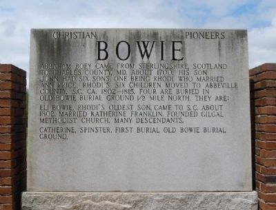
Abraham Boey came from Sterlingshire, Scotland to Charles County, Md. about 1700. His son John had six sons, one being Rhodi who married Ann Price. Rhodi's six children moved to Abbeville County, S.C. ca. . . . — — Map (db m43827) HM
On Greenville Street (State Highway 20) at Central Shiloh / Milford Dairy Road (State Highway S-1-100), on the left when traveling south on Greenville Street.
Erected by the descendants of Abraham Bowie, born in Scotland and settled in Durham Parish, Charles County, Maryland, about 1700 A.D. The family of his grandson Rhody Bowie, moved to Abbeville County, South Carolina about 1800. Eli Bowie, son of . . . — — Map (db m9338) HM
In memory of the first person, a young girl whose name is unknown. Buried here about 1760. The story goes that she was visiting the Lesly family and died as a result of injuries sustained while they were making lye soap. John Lesly and his . . . — — Map (db m18756) HM
On Greenville Street (State Highway 20) near Beltline Road (County Road S-1-35).
[Front]:
This cemetery, sometimes called Upper Long Cane Cemetery, dates from 1760. It includes the graves of some of the most prominent families of this area from the Colonial era to the present. The first marked grave is the field . . . — — Map (db m50740) HM
On State Highway 72 at Mt. Carmel Road (State Highway 823), on the left when traveling south on State Highway 72.
5.5 miles southeast is the burial ground of Patrick and Martha Caldwell Calhoun, Parents of John C. Calhoun; Deputy Surveyor 1756; First Representative from Up Country to Commons House of Assembly, 1769-1772; Member of First Provincial Congress, . . . — — Map (db m10627) HM
On North Church Street at Trinity Street, on the left when traveling north on North Church Street.
Trinity Episcopal Church is the oldest standing church in Abbeville. With its classic Gothic architecture and 125-foot steeple, it dominates the Abbeville skyline. Built by a congregation made prosperous by the economy of cotton in the antebellum . . . — — Map (db m11921) HM
On Broadmouth Church Road, on the right when traveling north.
[Front]:
This church, named for nearby Broadmouth Creek, was organized in 1837 with nine charter members. Rev. William P. Martin was its first minister, and William Long and Noah Riddle Reeve were its first deacons. This tract was . . . — — Map (db m36914) HM
John Callaham
Born in Virginia 1770
Migrated to South Carolina 1790
Died Level Land 1855
First Wife, Nancy Jarrett - Three
of Twelve Children of This Union
Married Sons of Zachariah Carwile.
Second Wife, Nancy Pinson - Eleven . . . — — Map (db m49923) HM
Forty graves in this cemetery
containing the remains of
Bartlett Tucker (1874-1861)
and members of his family
were relocated to this spot
from 0.22 acres s/w known as
Tract No. 1300 C-2 in 1983.
There were no identifiable marked . . . — — Map (db m58757) HM
On Hampton Avenue Northwest at Florence Street Northwest, on the right when traveling east on Hampton Avenue Northwest.
Aiken Colored Cemetery. This cemetery, established in 1852 as a city cemetery, became Pine Lawn Memorial Gardens in 1988. The only burial ground for African Americans in Aiken until the mid-20th century, it was laid out by the City of Aiken . . . — — Map (db m239016) HM
On York Street Northeast (U.S. 1) near Richland Avenue (U.S. 78), on the right when traveling south.
This church, founded in 1805, predates the city of Aiken and was first called Levels Baptist Church. Its first location was a mile south of present-day Aiken. In 1836 the congregation joined with the members of the Wise Creek congregation to . . . — — Map (db m10060) HM
(Front text)
This cemetery, established about 1850, is closely associated with the Graniteville Mill, the largest and most
successful textile mill in antebellum S.C. William Gregg (1800-1867), founder of the mill, laid out the mill . . . — — Map (db m43153) HM
On West Railroad Avenue (State Highway 39) near Pine Street, on the left when traveling north.
(Front)
A patriot and Christian
devoted to his country, his
family and his god.
He served his country well
as a member of Hart's Battery
and died loving the cause
for which he fought.
Dempsey Hammond Salley was
. . . — — Map (db m47645) HM
On Confederate Highway (State Highway 641) at Ulmer Road (State Highway 3-48), on the left when traveling west on Confederate Highway.
The original cemetery associated with St.
Nicholas Lutheran Church is 1/3 mile S off
SC Hwy 641. The church, originally located
nearby, was founded about 1804 in what was
then Barnwell District, and the cemetery
includes family plots of the . . . — — Map (db m7855) HM
Anderson Presbyterian
Church Cemetery
Founded 1837
Land Given by
Judge J.N. Whitner
Used as the First
Public Burial Ground
For the Village — — Map (db m49496) HM
On Due West Highway (State Highway 185) at County Road 17-60A, on the left when traveling west on Due West Highway.
[Front]:
This church, formally organized by about 1800, is thought to be the oldest Methodist congregation in Anderson County. Circuit riders and other itinerant ministers held early services in a nearby brush arbor. Its first and second . . . — — Map (db m55621) HM
On Flat Rock Road at Glen Eddie Road (South Carolina Highway 475) on Flat Rock Road.
Serving Country
and
Jesus Christ
Veterans Who Are buried
in Flat Rock Cemetery
[Left Column]
Harry Drake, Daniel Y. Culbertson, J.C. Culbertson, Luther M. Borders, John T Neims, Charles A. Thornton, Berry Faine, Edward . . . — — Map (db m54779) HM
In this burial ground
the first public burial ground
in the City of Anderson, S.C.,
rest fifty or more persons
known only to God.
This plaque is in honor of
those unnamed persons who
lived and died as a part
of the Anderson . . . — — Map (db m54638) HM
On East Greenville Street, on the left when traveling south.
Located 1.09 miles northwest, this cemetery marks the original site of Hopewell Baptist Church which was constituted in 1803. The cemetery contains graves of Revolutionary and Confederate veterans. Some graves are marked by field stones with . . . — — Map (db m10724) HM
Deeded to the City in 1992, these humble grounds are the final resting place for some Orr Mill employees and family members dating to the 1800s. Numerous graves are here, marked and unmarked, including infants.
Help us improve these unique . . . — — Map (db m50102) HM
Near Sayre Street (U.S. 29), on the right when traveling south.
In Memory of World War Casualties
War No. I
Thomas Adjer
Scott Hill
Ollie Rutledge
War No. II
James Joyner
Johnnie M. Leroy
Frank Lewis
John M. McBride
Mayor
Richard A. Shirley
City Manager
John R. . . . — — Map (db m49493) HM
On Three and Twenty Road (State Highway 485), on the left when traveling south.
This land, Cherokee territory until 1777, became the final resting place after the American Revolution for early pioneers who settled the area. A number of soldiers of the Revolution are buried here including Robert Pickens, who served in the . . . — — Map (db m9087) HM
On Brushy Creek Road at Colonel Johnson Road, on the right when traveling west on Brushy Creek Road. Reported missing.
[Front]:
This church, founded in 1803, held its first services in the home of John Wilson and was first known as Wilson's Chapel. That year the congregation bought two acres here from George Head; the first church on this site was built . . . — — Map (db m47088) HM
On Honea Path Highway (State Highway 252) at Barkers Creek Road, on the right when traveling south on Honea Path Highway.
Founded in 1821, this is the boyhood church and burial place of Olin D. Johnston. He was decorated for bravery in World War I, served in the S.C. House of Representatives, was twice Governor of S.C., in 1935-1939 and 1943-1945, and U.S. Senator from . . . — — Map (db m9335) HM
This church, the first Associate Reformed Presbyterian congregation in what is now Anderson County, was organized about 1790 about 1 1/2 mi. SW of this site. Rev. Robert Irwin, its first regular minister, served from 1803 until his death in . . . — — Map (db m11747) HM
On Old Lowndesville Highway, 0.1 miles south of Cemetary Road, on the left when traveling south.
This cemetery, dating from the early 19th century, is at the third site of Good Hope Presbyterian Church, founded in 1789. A frame sanctuary was built here in 1856 during the tenure of Rev. David Humphreys (d. 1869), who preached here 1821-1869 . . . — — Map (db m19945) HM
This is the site of a small cemetery used by the Reece family in the 19th century. Because cattle roamed freely in this area for years, the tombstones and other grave markings are broken. In 1977, the readable tombstones were recorded by family . . . — — Map (db m11091) HM
On East Queen Street (State Highway 88) at North Broad Streets, on the right when traveling north on East Queen Street.
This London newspaper publisher and defender of a free press emigrated to Charleston in 1783 where he served as state printer and publisher of the first daily newspaper in South Carolina. Later in Pendleton he founded Miller's Weekly . . . — — Map (db m144322) HM
On Cherry Street Extension (State Highway 115), on the right when traveling east.
Born in 1840, Colonel Simpson, lawyer, farmer, and legislator, drafted and executed Thomas Green Clemson's will, establishing Clemson Agricultural College in 1889. Simpson was first president of the college's board of trustees and once owned land . . . — — Map (db m9682) HM
The paved brick walk leads to the gravesite of Thomas Green Clemson, founder of Clemson University. He was a Scientist, Agriculturist, Statesman, and Educator. His gift to South Carolina of an Institution for the promotion of education in the fields . . . — — Map (db m13938) HM
On Anderson Highway (State Highway 28 / 76) 0.1 miles south of Excelsior Mill Road.
Dedicated in 1979
in Honor of
Thomas Green Clemson
1807-1888
A Native Philadelphian and
Leading Agriculturist. Mr.
Clemson was U.S. Charge
D'Affaires to Belgium, U.S.
Superintendent of
Agriculture, and the
1868 President . . . — — Map (db m16617) HM
On Fairplay Road near Rogers Farm Road, on the left when traveling south.
Nazareth on the Beaverdam Presbyterian Church. This is the first known site of Townville Presbyterian Church, founded in this area in 1803 as Nazareth on the Beaverdam Presbyterian Church. The church held its services at members' homes until . . . — — Map (db m10784) HM
On East Greenville Street at Hamilton Street, on the right when traveling west on East Greenville Street.
One of the oldest congregations and the mother of several others in Anderson County, it was organized in 1788 by Elder Moses Holland who served as pastor for 41 years. Dr. James Bruton Gambrell's mother was a member here. Soldiers of five wars . . . — — Map (db m8441) HM
On West Main Street (State Highway 20) at Minor Street, on the left when traveling west on West Main Street.
"Embraced by the gratitude of an entire community and held in the love and admiration of a descended family, here rests the earthen tabernacles of our beloved founder, West Allen Williams, and family. Reverently moved from a forgotten cemetery a . . . — — Map (db m19714) HM
Eleven years after the battle of Rivers Bridge,
a group of local young men formed the Rivers
Bridge Confederate Memorial Association and
reburied the Confederate dead here, about a
mile from the battlefield. The Memorial
Association began to . . . — — Map (db m15671) HM
Most of the Confederates killed here were Georgians,
and most were unknown when they were reburied. But
the local community remembered them as " our
Confederate dead, " the fallen heroes of a common cause. The monument placed over their mass . . . — — Map (db m15650) HM
( Front face )
In Memory
of our
Confederate Dead
who fell in battle at
River's Bridges
Feb. 4, 1865.
(Reverse face ) Soldier's rest, your welfare o'er,
Sleep the sleep . . . — — Map (db m15652) HM
On Salem Church Road at Juniper Creek Road (South Carolina Highway 5-366), on the right when traveling west on Salem Church Road.
This church, founded by 1818, held its early services in a brush arbor; the first permanent sanctuary was built nearby. In 1848 Capt. J.D. Allen sold this 4-acre site to the trustees for $1.00. The present church, built soon afterwards, has been . . . — — Map (db m32092) HM
On Burton Ferry Road (U.S. 301) at Mizpah Lane, on the right when traveling south on Burton Ferry Road.
Methodist Church
established by 1832.
Present 1856 house of
worship is all that
remains of pre~ Civil
War Settlement of
Buford's Bridge. — — Map (db m19641) HM
On Jackson Street (U.S. 278), on the left when traveling north.
Sometimes called the Red Hill Cemetery. Original site of Barnwell First Baptist Church. First Baptist Church is the oldest continual
institution in Barnwell. Established in 1802. Both the 1850 building and the 1926 building stood on this site. . . . — — Map (db m72643) HM
On Boiling Springs Road (State Highway S-6-39), on the left when traveling west.
(Front text)
The grave of Tarlton Brown (1757 - 1845),
militia officer, state representative, and
state senator, is located here. Brown, a
native of Virginia, moved to S.C. at an
early age and settled in what was then
Orangeburg . . . — — Map (db m8791) HM
Near Boundary Street (Business U.S. 21) west of Bladen Street, on the right when traveling west.
Civil War Dead An estimated 700,000 Union and Confederate soldiers died in the Civil War between April 1861 and April 1865. As the death toll rose, the U.S. government struggled with the urgent but unplanned need to bury fallen Union troops. . . . — — Map (db m134423) HM
Near Boundary Street (Business U.S. 21) west of Bladen Street, on the right when traveling west.
National Cemetery Beaufort National Cemetery was established in 1863. The U.S. Army Quartermaster General's Office laid out the 22 acres in sections that radiate outward from a central plaza to form a half circle. Of the 9,226 interments here . . . — — Map (db m134421) HM
Near Newcastle Street north of North Street, on the left when traveling north.
Born in Dublin Ireland in 1671
Son of Jacobite, Alderman Matthew Barnwell
Immigrated to South Carolina in 1701
Protege of Governor Nathaniel Johnson
and Chief Justice Nicholas Trott
Deputy Surveyor in 1703
Clerk of the Council 1703 . . . — — Map (db m148755) HM
(Tablet One)
The Governor of the Commonwealth of
Massachusetts Michael S. Dukakis, and
descendant's of the African-American Civil
War Volunteers of the 54th and 55th Infantry
Regiments and the 5th Cavalry Regiment of
Massachusetts, . . . — — Map (db m20211) HM
On Charles Street near Prince Street, on the right when traveling south.
" Here, in 1794, I had the happiness,
instrumentally, to lay the foundation of
a place of worship which composed of
the best materials, and classes with the
most neat and commodious Baptist
meetinghouses in the United States."
(Rev. . . . — — Map (db m25958) HM
On Church Street south of King Street when traveling south.
(Marker Front):
This Episcopal Parish was established by Act of the Assembly June 7, 1712. The first known rector, William Guy, conducted early worship services in homes of settlers. The parish suffered greatly during the 1715 Yemassee . . . — — Map (db m5827) HM
†
St. Helena's Parish was established June 7, 1712
by act of Provincial Assembly. First rector,
The Rev. William Guy, was appointed 1713; Glebe lands of 50 acres provided 1717.
Original church erected 1724; Enlarged
1770 and . . . — — Map (db m25741) HM
On Charles Street near King Street, on the right when traveling south.
Established as a mission of the Euhaw Baptist
Church in 1795, Henry Holcombe, pastor.
With Joseph B. Cook as pastor, the church
was chartered as a Baptist church by the
State of South Carolina on January 27,1804.
At the beginning of the Civil . . . — — Map (db m26102) HM
Near Prospect Road east of Martinangele Road, on the right when traveling east.
Phillip Martinangele, born in Italy, immigrated to this country and settled in St. Helena’s Parish. He married Mary Foster in 1743, but had died by 1762 when his widow bought 500 acres
on Daufuskie Island. Their son Phillip, a captain in the . . . — — Map (db m244107) HM
Near Old Sheldon Church Road north of Trask Parkway, on the right when traveling north.
William Bull
of Sheldon
Born 1683 Son of Stephen Bull,
the Immigrant
Member Colonial House of Commons
1706 - 1719
Colonel of Berkeley County Regiment
Tuscarora and Yemassee Wars.
Lord's Proprietors Deputy 1719.
Member and President . . . — — Map (db m106135)
When the South Carolina Public Service Authority was clearing the lands for the Santee Cooper Lakes, and removing buildings and other things man had erected during his two and a half centuries in upper Berkeley, there were numerous small items of a . . . — — Map (db m54776) HM
Near end of General Francis Marion Avenue, on the right when traveling north.
(North face) Sacred to the Memory
of
Genl. Francis Marion,
Who departed his life, on the 27th of February, 1795,
in the sixty-third year of his age
Deeply regretted by all his fellow-citizens.
History will record his worth . . . — — Map (db m23902) HM
On Colonel Maham Drive at Westfield Drive, on the right when traveling south on Colonel Maham Drive.
Burial place of Col. Hezekiah Maham A native of St. Stephen's Parish Berkeley County, South Carolina Born 1739 Died 1789 He was a distinguished soldier and patriot of the American Revolution — — Map (db m54777) HM
On Mendle Rivers Road (State Highway 8-351) at Brick Church Circle, on the right when traveling south on Mendle Rivers Road.
Lucius Mendel Rivers (1905-1970), state representative 1933-36 and U.S. Representative 1940-70, was born in nearby Gumville and grew up on the family farm on Bonneau Road (now Mendel Rivers Avenue). Rivers attended the College of Charleston and the . . . — — Map (db m29330) HM
On Mt. Lebanon Road, 0.5 miles west of Old State Road (U.S. 176), on the right when traveling west.
This is the original site of Mt. Lebanon Lutheran Church, organized January 13, 1844, as an extension of the St. Matthew's Church, Creston. Later, Mt. Lebanon Church moved to Cameron about 2 miles NW, dedicated its new building in 1917, and was . . . — — Map (db m27239) HM
On Old State Road (U.S. 176) north of Shrike Road, on the right when traveling north.
Burial place of Lt. Col. Olin M. Dantzler, C.S.A. Appointed Brigadier General 1 June 1864 Defender of Charleston, SC and Petersburg, VA His recorded notes to General P.G.T. Beauregard led to the location of the submarine H.L. Hunley in 1995 Killed . . . — — Map (db m134424) HM
Near Fifteen Mile Landing Road, 0.1 miles west of Ocean Highway (U.S. 17), on the right when traveling west.
This Stone marks the spot where the Wappetow Independent Congregational Church stood. This church was planted here in 1696 by a colony of 52 who came from New England and landed at Seewee Bay. — — Map (db m206024) HM
(Front) A cemetery established here in 1841, also known as “God’s Acre” and later “the German Cemetery,” was maintained by St. Matthews Evangelical Lutheran Church until about 1860. That church, founded in 1840 by the . . . — — Map (db m44096) HM
On Calhoun Street, on the right when traveling east.
The National Register
of Historic Places
South Carolina
Department of Archives
And History
Charleston
Old E. Historic District
Harleston Boags Funeral Home
(Lower Plaque)
Harleston - Boags Funeral Home . . . — — Map (db m51484) HM
This marble for thirty four years covered the tomb of Calhoun in the Western Churchyard. It has been placed here by the Vestry near the spot there he remains were interred during the siege of Charleston from which spot they were afterwards . . . — — Map (db m48142) HM
Near Church Street north of Queen Street, on the right when traveling north.
October 26, 1757 – October 29, 1824 He was a delegate to the Continental Congress, 1784-5, 1785-6, 1786-7 He was a delegate to the Federal Convention in 1787 and on May 29, 1787 submitted thereto a plan for a Constitution and at least . . . — — Map (db m67965) HM
In memory of
Elizabeth Hutchinson
Jackson
Mother of
Andrew Jackson
President of the U.S. 1829-1837
Who gave her life in the
cause of independence
while nursing Revolutionary
soldiers in Charles Town
and is buried in . . . — — Map (db m27509) HM
Near Church Street north of Queen Street, on the left when traveling north.
Born March 18, 1782;
Died March 32, 1850.
Representative in the Legislature;
Member of Congress;
United States Senator.
Secretary of War;
Vice President;
Secretary of State.
Erected by the State of South Carolina
A.D. . . . — — Map (db m212242) HM
On Meeting Street near Broad Street, on the right when traveling west.
The following people were buried at the Quaker meeting house graveyard on King Street and were reinterred at this site in 1974.
(Left Column)
John Allen - 1720
Bena Austin - 1735
John Cooper - 1715
Mary Fisher Bayly Crosse - . . . — — Map (db m47770) HM
Herein Lie the Remains of Richard Hutson 1747 - 1795 son of Rev. William and Mary Woodward Hutson
South Carolina Patriot, Statesman and Jurist Graduated Princeton 1765
Founding Body The College of Charleston 17-72 - 1794 Member S.C. general . . . — — Map (db m19238) HM
On Church Street, 0.1 miles north of Queen Street, on the right when traveling north.
Here in the churchyard of
St. Philip's are buried
Charles Pinckney
(1757-1824)
Signer of the United
States Constitution
and author of the famous
"Pinckney Draught"
Governor of South Carolina
U.S. Senator & Congressman . . . — — Map (db m27541) HM
On Mary Murray Drive at 10th Avenue, on the left when traveling west on Mary Murray Drive.
(front)
Hampton Park was once home to the Washington Race Course and Jockey Club. In 1864 this site became an outdoor prison for Union soldiers. Before Charleston fell in Feb. 1865, more than 250 prisoners died and were buried in mass . . . — — Map (db m205351) HM
On Logan Street, on the right when traveling north.
In 1912, Julius P.L.Fielding established a funeral business on the northeastern corner of King and Queen Streets. In 1928, Julius acquired 122 Logan Street, a three-story Georgian style structure built in the 1700s with 12-inch thick exterior walls . . . — — Map (db m51443) HM
On this site stood two successive meeting houses and the burial ground of the Society of Friends or Quakers. The site was deeded to the Quakers circa 1681 by South Carolina Governor John Archdale, a prominent Charleston Quaker and owner of a . . . — — Map (db m47876) HM
On Archdale Street south of Clifford Street, on the right when traveling north.
This church grew from services held for German inhabitants in Charleston by Rev. Johann Martin Boltzius in 1734 and Rev. Henry Melchior Muhlenberg in 1742. The cornerstone of the first house of worship was laid in 1759; the second and present church . . . — — Map (db m11228) HM
On Cunnington Avenue, on the right when traveling east.
(North face)
In
The Confederate Army
the Soldiers
Whom this Monument
Commemorates
Illustrated in Death as in Life
The German's Devotion to Duty
Beneath this monument, repose
the remains of
John A. Wagener, . . . — — Map (db m40748) HM
On Meeting Street Road (U.S. 52) near Cunnington Avenue, on the right when traveling north.
(Front text)
Magnolia Cemetery, established in 1850, was named for Magnolia Umbra Plantation, dating back to 1784. The ca. 1800 house built by Col. William Cunnington serves as the cemetery office. This is a fine example of the "rural . . . — — Map (db m23280) HM
Here in the churchyard of
St. Michael's lie buried
two Signers of the
U.S. Constitution
Charles Cotesworth
Pickney
(1746-1825)
Lawyer and Legislator
Major General, U.S. Army
Minister to France
Presidential candidate . . . — — Map (db m19102) HM
On Logan Street, on the right when traveling north.
Church built in 1835
Destroyed by fire 1861
Merged with Christ Church
Rutledge Ave. and Sumter St.
which was torn down and
new St. Peter's built in 1931
Moved to Miles Drive 1973 — — Map (db m48854) HM
On Rifle Range Road near South Carolina Highway 10-51, on the right when traveling south. Reported missing.
Cook's Old Field Cemetery
This plantation cemetery predates the American Revolution. It was established by early members of the Hamlin, Hibben and Leland families. James Hibben (d. 1835), one of the founders of Mount Pleasant, is buried . . . — — Map (db m52763) HM
Near U.S. 17,701 near Old Georgetown Road (South Carolina Highway 10-1808), on the right when traveling north.
Foundation Laid in 1707
The first clergyman in 1708
Rev.Edward Marston and Vestry follows
David Maybank and Henry Gill, Wardens
Thomas Barton, William Capers,
Leonard Hickman, John Simes,
Richard Fairchild, John Hale,
and . . . — — Map (db m38865) HM
On U.S. 17 near opposite Long Point Road, on the right when traveling north.
The Church Act of 1706 created Christ Church Parish. The first church, a wooden structure built in 1707, accidentally burned in 1725. A brick church was erected in 1726, and although the British burned it in 1782 and the interior was destroyed by . . . — — Map (db m38264) HM
South face
By the united efforts
and enduring sacrifices
of the
Noble woman of Mount Pleasant
and Charleston.
The zealous and tender
custodians of the slumbering
Heroes of a lost cause.
This Monument
has been . . . — — Map (db m40014) HM
Edmund Jenkins Edmund Jenkins, a veteran of World War I, was the first elected black Town Marshal in Mount Pleasant, and served the Town from 1920-1927. He died December 26, 1930. His gravestone is directly to the left of this marker. The . . . — — Map (db m38036) HM
Near Robert Mills Circle near Edenton Road, in the median.
This family cemetery is also known as the
Hobcaw Cemetery, the Bond Family Cemetery,
and the Read Family Cemetery.
Only fragments of the old gravestones remain.
It is likely that the cemetery was first used in
1713 to bury David Maybank, . . . — — Map (db m39256) HM
On Mathis Ferry Road (State Highway 10-56) near North Shelmore Blvd., on the right when traveling south.
(Front text)
Jacob Bond I'On (1782-1859), planter, U.S. Army and militia officer, and state legislator, is buried in the family cemetery 1/2 mi. north. I'On, a contemporary of John C. Calhoun at Yale University, represented St. James . . . — — Map (db m37964) HM
“Rich in red honors, that upon him lie as lightly as the summer dews fall where he won his fame beneath the sky of tropic Vera Cruz” In memory of Brig.-Gen. R. S. Ripley, C.S.A. Born at Worthington, Ohio, 14th March 1823. Graduated at . . . — — Map (db m81835) HM
On Cunnington Avenue Loop, on the left when traveling east.
Here rests the crew of the
Confederate Submarine Hunley
Died on October 15, 1863 when
making a practice dive in the harbor
Horace L. Hunley
Robert Brockbank
Joseph Patterson
Thomas W. Park
Charles . . . — — Map (db m23302) HM
Micah Jenkins, Brig. Gen. C.S.A. Born Dec. 1835 Edisto Island, S.C. -------------- A graduate of the Citadel Academy with first honors. Killed at the head of his brigade in the Battle of the Wilderness, May 6th, 1864. “Integer . . . — — Map (db m67998) HM
On Cunnington Avenue Loop, on the right when traveling east.
Appropriated by Magnolia Cemetery at the request of the Confederate Government for burial of those men who fought and died defending the cause. Among the fallen are 82 Confederate Soldiers that died on the battlefield at Gettysburg. In 1871, the . . . — — Map (db m24026) HM
On State Highway 162, on the right when traveling east.
St. Paul's, Stono St. Paul’s Parish, one of the ten original parishes of colonial S.C., was created by the Church Act of 1706. The first parish church was built in 1708 on a bluff overlooking the Stono River. The parsonage and outbuildings were . . . — — Map (db m39900) HM
On Station 22 1/2 Street (State Highway 703) north of Myrtle Avenue, on the left when traveling south.
[Marker Front]:
In this cemetery are the remains of some of Sullivan's Island's original Islanders, people of predominantly African American descent whose history parallels that of the Island.
Buried here are Carpenters, Cooks, . . . — — Map (db m19117) HM
Near Middle Street west of Station 13 Street, on the right when traveling west.
Major General William Moultrie
1730 - 1805
Commander of
Second South Carolina Regiment
During the Battle of Sullivan's Island
June 28, 1776
When offered inducements by Lord Charles
Montagu to desert the American cause,
General . . . — — Map (db m108527)
(Grave Marker):
Oceola
Patriot and Warrior
Died at Fort Moultrie
January 30th 1838
(Historical Marker):
A Seminole Leader
Perhaps Fort Moultrie's most celebrated resident was Osceola, famed Seminole leader who led . . . — — Map (db m15425) HM
On Battleground Drive (State Highway 216) at Rock House Road, on the left when traveling south on Battleground Drive.
[Front]:
Col. Frederick Hambright (1727-1817), a prominent militia officer of the American Revolution, lived his last 25 years in a house which stood 200 yds. NE. Hambright, born in Germany, emigrated to America as a boy, and settled in . . . — — Map (db m28236) HM
On El Bethel Church Road (State Highway 11-15) when traveling east.
The family cemetery of Lt. Col. James Steen (d. 1781), S.C. militia officer during the American Revolution, is on his plantation nearby, along Thicketty Creek. Steen, who commanded units in several campaigns from 1775 to 1781, was killed in 1781 . . . — — Map (db m44670) HM
On Asbury Road (State Highway 211), on the right when traveling west.
This African American church, the first in what is now Cherokee County, was most likely built between 1880 and 1890. It served the Whig Hill, Asbury, and Thickety communities of what was Union County before Cherokee County was created in 1897. . . . — — Map (db m19724) HM
On State Highway 97 at Old Catholic Church Road, on the right when traveling east on State Highway 97.
Divergent Presbyterian groups held services in this area as early as 1759. Rev. William Richardson, active in the area, is credited with unifying and naming them in 1770. The cemetery contains many graves of Revolutionary and Confederate . . . — — Map (db m13687) HM
Near Old Catholic Church Road (County Route 355) 0.9 miles south of Great Falls Highway (South Carolina Route 97), on the right when traveling south.
Rev William Martin 1716-1806 •
Col. John Nixon 1780 Capt. John Steel 1750-1810 •
Capt. Hugh Knox 1755-1821 Capt. Benj. Land 1780 •
Robert Archer 1748-1818 John Corder •
William Anderson 1744-1780 John Lee 1760 •
John Bailey David McCalla . . . — — Map (db m245568) WM
On Steele Village Road at Fishing Creek Church Road, on the right when traveling north on Steele Village Road.
Presbyterian church reportedly est. 1752. Present building, enclosed with brick in 1958, dates from 1785. Cemetery contains pioneer settlers and veterans of many wars. — — Map (db m121921) HM