[Front Side]
In Memory of
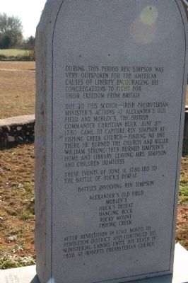
The Reverend John Simpson
1740-1808
Wife
Mary Remer
1743-1812
Minister
Educator
Soldier
Patriot
Married 1765- New Jersey
Graduated Princeton College with high honors 1768
Studied . . . — — Map (db m13799) HM
St. Paul Baptist Church at HalsellvilleThis congregation, originally known as St. Paul Colored Baptist Church, was formally organized by 1884 on nearby Goings Road. The church moved to this location in 1901. Members acquired the land for . . . — — Map (db m246066) HM
St. David's, authorized by the General Assembly in 1768, was the last parish established in colonial S.C. Said to be buried in its churchyard are soldiers of British forces occupying the Cheraws in 1780. The steeple and vestibule of this . . . — — Map (db m28270) HM
Encamped at Cheraw Hills in the summer of 1780 during the American Revolutionary War.
The Fraser Highlanders were recruited in Scotland in 1775 by their Clan Chief Simon Fraser, Master of Lovat, to serve in the army of King George III. They . . . — — Map (db m54803) HM
(Front) This cemetery was established about 1739 by Joseph Cantey (d. 1763), planter and member of the Commons House of Assembly. It is on the site of Mount Hope, Cantey's plantation near the Santee River. Cantey served what was then Craven . . . — — Map (db m53882) HM
After the American Revolution, General Marion’s militiamen re-built his home. Francis Marion, at age 53, married Mary Esther Videau, April 20, 1786. They lived at Pond Bluff, on the south edge of the Santee Swamp and raised pineland cattle. With . . . — — Map (db m43156) HM
Three hundred yards west is the site of one of the earliest graveyards in St. Mark's Parish.
In the cemetery are buried Richard Richardson, Brigadier in the Revolution, James Burchell Richardson, South Carolina Governor 1802-04, and John Peter . . . — — Map (db m23495) HM
According to local tradition, this Methodist congregation was organized in 1786 and pioneer American bishop Francis Asbury later visited the area a number of times. The church stands today on land given by Ellis R. and Mary A. Richbourg in 1880. . . . — — Map (db m24465) HM
[Front]:
Cross Swamp Methodist Church, the first Methodist congregation in upper Colleton County, was founded in 1808. James and Asia Sineath deeded an acre on this site to church trustees in April and the first sanctuary, which was a . . . — — Map (db m27161) HM
On Parker's Ferry Road one mile northeast of here are the ruins of Pon Pon Chapel of Ease, established in 1725 by an Act of the General Assembly after the Yemassee War aborted plans for St. Bartholomew's Parish Church. John Wesley preached here in . . . — — Map (db m7073) HM
1706 Parish Established
Rev. Nathaniel Osborn, Missionary of the S.P.G. arrived
1715 Parish devastated by Yemassee, Indians
1725 Act of General Assembly provided for a Chapel of Ease here to be used as a Parish Church until one should be built . . . — — Map (db m7120) HM
This U.S. Naval officer was born in Maryland
in 1782 and died at his plantation in St.
Bartholomew's Parish, S.C. in 1823. He served
as acting captain of the frigate "Constitution" in
1804 during the war with Tripoli, and was senior
officer . . . — — Map (db m7881) HM
This was formerly the site of a
Presbyterian church organized in
1766 by the Reverend Arichibald
Simpson, minister from Scotland.
The church was incorporated on
December 17, 1808. Serving the
church were the Reverends Simpson,
Edward . . . — — Map (db m7118) HM
The cemetery one-half mile west is on the site of a meeting house deeded to the Methodist Society by John Fontaine in 1802. Bishop Francis Asbury had held services at Island Creek on March 4, 1796, in "a pole house." In 1882 the members had moved to . . . — — Map (db m176608) HM
In the summer of 1865, just after the end of the Civil War, Federal troops began their occupation of many cities and towns in S.C. Units in Darlington in 1865-1866 included the 15th Maine Infantry, 29th Maine Veteran Volunteers. They camped on the . . . — — Map (db m13570) HM
Side A This cemetery, established in 1890, was originally a five-acre tract when it was laid out as the cemetery for the nearby Macedonia Baptist Church. The first African American cemetery in Darlington, it includes about 1,900 graves . . . — — Map (db m38111) HM
Grove Hill Cemetery, the first public cemetery in Darlington, was chartered in 1889. Citizens founded it “on account of the health of our town but also on account of the great scarcity of space in the church cemeteries.” The original . . . — — Map (db m47812) HM
Marker Front: Mount Pleasant Baptist Church Mount Pleasant Baptist Church, organized by 1785, first met in a nearby school. It built a sanctuary here in 1791; that year Cashaway Baptist Church merged with it. In 1818 the congregation . . . — — Map (db m38120) HM
The First Methodist Church was built in 1831 on land donated by Moses Sanders in 1830. This was five years before Darlington was chartered. It was a plain barn like building, not plastered or ceiled. A great revival was held in the church was held . . . — — Map (db m60606) HM
The earliest record of this church dates to 1789, when it belonged to the Charleston Baptist Association and had 76 members. It took its name from, and built its first and later churches near, Swift Creek. The congregation grew after a revival in . . . — — Map (db m218670) HM
(side 1)
The first meetings of what would become St. John Methodist Church took place under a brush arbor. The congregation completed their first permanent sanctuary, a one-room frame structure, in 1867. Having outgrown that building, . . . — — Map (db m222984) HM
March 8, 1776-November 17, 1830 Statesman, educator, pioneer manufacturer, scientific farmer, State Senator, Congressman, Governor 1814-1816, Brigadier General in the War of 1812. His residence, "Center Hall," was ½ mile east. His grave is in . . . — — Map (db m38142) HM
(Front text) This church was organized shortly after the Revolution and this site was deeded to seven trustees in 1787. One of them, Jacob Barr, was the first minister to serve here. Appleby’s Methodist Church was named for a prominent local . . . — — Map (db m26275) HM
Edgefield United Methodist Church
By 1841, this congregation was established and was a member of the Edgefield circuit. The present structure was dedicated in November of 1892 by Bishop W.W. Duncan. The Reverend Joseph Moore sold to the church . . . — — Map (db m12656) HM
First Baptist Church
Founded in 1823 as Edgefield Baptist Church, with Basil Manly, Sr., Pastor, Matthew Mims, Clerk, and Arthur Simkins, Moderator, this church led in the establishment here in 1826 of Furman Academy and Theological . . . — — Map (db m12671) HM
From 1858 to 1860 he was U.S. Minister to Russia. As Governor, his order to fire on a Union Ship in Charleston Harbor led to the start of the War Between the States. He lived at Edgewood, one of Edgefield's greatest homes. He is buried in . . . — — Map (db m12905) HM
He served a Speaker of the South Carolina House and was elected Lieutenant Governor in 1882 and 1884. Sheppard was a leader of the Conservative movement of the 1890's in opposition to Tillman. He is buried in Willowbrook Cemetery in Edgefield. — — Map (db m12912) HM
The youngest Governor in South Carolina history, Evans served in the House and Senate before being elected Governor. He was a veteran of the Spanish-American War and is buried in Willowbrook Cemetery in Edgefield. — — Map (db m12923) HM
1/2 mile west, on "Ceder Fields" plantation, is buried the family of Captain Arthur Simkins, soldier in the American Revolution and a founder of Edgefield. Born in Virginia on Dec. 10, 1742, he died Sept. 29, 1826. He was a county court judge, a . . . — — Map (db m12333) HM
Richard Tutt House
The Tutt house which formerly stood on this site is believed to have been the first home at Edgefield Court House. Richard Tutt was one of the party who in October 1775 arrested Tory leader Robert Cunningham and escorted him . . . — — Map (db m12767) HM
This Court House Square, which was identified as the site of the courthouse and jail for the newly established Edgefield District in 1785, has been the center of life here for over two centuries. Today the present courthouse, which was built in . . . — — Map (db m12638) HM
On May 9, 1803, the Associate Reformed Synod of the Carolinas was organized here at Ebenezer A.R.P. Church, built in 1788 by a congregation dating from colonial days. The rock wall was added in 1852. Damaged by Union troops in 1865, the church was . . . — — Map (db m121864) HM
[Front]
This camp ground, described by one journalist as "picturesque, rugged, simple, with an overhanging air of festivity," has hosted an annual camp meeting since 1876; slaves had worshipped here before the Civil War. The site was . . . — — Map (db m14613) HM
Here lie buried many of the Scotch Irish pioneers, who, in 1772, under the leadership of the Rev. William Martin, founded one of the first Covenanter churches in upper South Carolina. — — Map (db m14506) HM
(west face)
M Z S
1777.
JACOBO WILSON HUDSON,
Montis Zion Collegii annos vigenti tres.
singulari felicitate Præsidi.
Multa præclara in tam longissimo
curriculo et didicit et docuit.
In literis eruditus, in . . . — — Map (db m45128) HM
Organized before 1785, this Presbyterian Church was originally known as Wolf Pit Church, later as Wateree, and was finally named Mt. Olivet in 1800. The Reverend William Martin, Covenanter minister licensed by the Reformed Presbytery of Scotland, . . . — — Map (db m121865) HM
Civil War Dead
An estimated 700,000 Union and Confederate soldiers died in the Civil War between April 1861 and April 1865. As the death toll rose, the U.S. government struggled with the urgent but unplanned need to bury fallen Union . . . — — Map (db m149425) HM
Civil War Dead
An estimated 700,000 Union and Confederate soldiers died in the Civil War between April 1861 and April 1865. As the death toll rose, the U.S. government struggled with the urgent but unplanned need to bury fallen Union . . . — — Map (db m149953) HM
Jews have lived in Florence since the city’s founding in the 1850s and were among its early civic leaders. Local Jews first formally organized in 1887 as the Florence Hebrew Benevolent Association. The group’s mission was to promote community and . . . — — Map (db m224005) HM
(Front):
One each side of this marker lie the remains of approximately 2300 Union soldiers who died as prisoners in the Florence Prison Stockade, between September 1864 and February 1865. The Stockade was located across Cemetery Street on . . . — — Map (db m45963) HM
The Florence National Cemetery
established in 1865
is this day re-dedicated
to the memory of all the
patriotic men and women
who answered their
country's call to service
their inspiring contribution
will help preserve in the
. . . — — Map (db m45967) HM
National Cemetery
In 1865, the U.S. Army quartermaster general designated the original 3.76-acre prison cemetery as Florence National Cemetery. It contains not only the bodies of Union prisoners who died in Florence, but soldiers removed . . . — — Map (db m149474) HM
Florence Prison Stockade
In early September 1864, General William Tecumseh Sherman's Union army took Atlanta and came within striking range of the large Confederate prison at Andersonville, Georgia. he Confederate government responded to . . . — — Map (db m149984) HM
Front
This church, organized ca. 1770, is the first Presbyterian church in what is now Florence County. Many of its founding families came to S.C. from Scotland and Ireland. The first church here, a frame building, stood across Old River . . . — — Map (db m37328) HM
President of Wilmington & Manchester Railroad and a founder of the city of Florence, Harllee (1812-1897) was also a general in the SC Militia, signer of Ordinance of Secession, Lt. Governor (1860-62), member of the General Assembly, and president . . . — — Map (db m37307) HM
History of the Park
The Dr. Ronald E. McNair Memorial Park was officially dedicated on April 29, 1995. The Memorial Park is the results of planning which began in 1989 as a joint collaboration of the Ron McNair Committee, the City of Lake . . . — — Map (db m238135) HM
[Front] This church, founded in 1868 with Rev. James Wesley Johnson as its first minister, held its early services in a brush arbor. In 1870 trustees purchased this 1 ¾ acre tract to build a “Negro Schoolhouse” sponsored by the . . . — — Map (db m37336) HM
Roseville Plantation Slave And Freedman's Cemetery This was originally the slave cemetery for Roseville Plantation. Roseville, established about 1771 by the Dewitt family, was later owned by the Brockinton, Bacot, and Clarke families from the . . . — — Map (db m37337) HM
(Front)
This is the site of a "Dissenter" meeting house, built ca. 1726 by one of the first Baptist congregations in S.C. outside of Charleston. It was founded by Rev. Elisha Screven (d. 1754). The elder Screven had founded a Baptist . . . — — Map (db m243938) HM
Antipedo Baptist Church In the plan of Georgetown, laid out by 1730, this one acre lot was reserved for Antipedo Baptist by Elisha Screven. A brick building built before the Revolution for the Baptists, Presbyterians, and independents housed the . . . — — Map (db m4889) HM
This cemetery, established ca. 1772, is the second oldest Jewish cemetery in the state and serves a community which has been significant here since well before the American Revolution. Abraham Cohen and Mordecai Myers, who opened stores in the town . . . — — Map (db m4857) HM
Birthplace of Jeremiah John Snow. China Grove was the birthplace of the Reverend Jeremiah John Snow (1836–1892), a son of the third James Snow who lived here. He entered the Methodist Conference in 1863, and was a chaplain in the Third . . . — — Map (db m16513) HM
(front)
Bishop Francis Asbury first arrived in Georgetown in Feb. 1785 and would return in 1786, at which time he established a slave mission at Boone Plantation on the Sampit River. Asbury would return many times over the years and his . . . — — Map (db m202218) HM
From the 1880's to the 1930's the block bordered by Highmarket, Dozier, Duke and Church streets served as a cemetery for criminals, the indigent and the unknown. These types of cemeteries were located in many towns and communities and were . . . — — Map (db m184660) HM
Here are buried William Screven (1624–1713) and other members of his family. A native of England, he migrated to Kittery, Me., and was persecuted by New England authorities for non-conformity. He and other members of the Kittery Church came to . . . — — Map (db m7612) HM
Sacred to the Memory of Joseph & Theodosia Burr Alston and their Son Aaron Burr Alston. This last died in June 1812 at the age of 10 years and his remains are interred here. The disconsolate Mother perished a few months after at sea. And on the 10th . . . — — Map (db m40376) HM
Joseph Alston (1779–1816) was educated at the College of Charleston and at Princeton. He inherited The Oaks Plantation and in 1801, married Theodosia, daughter of Aaron Burr. Alston was a member of the S.C. House (1802–12), its speaker . . . — — Map (db m16512) HM
Daughter of Aaron Burr and one of the most learned women of her era; wife of Governor Joseph Alston, who is buried west of here, with Aaron Burr Alston, their ten-year-old son; sailed from Georgetown on Dec. 30, 1812 on the schooner Patriot . . . — — Map (db m16462) HM
The cemetery located about ½ mile north, marks the site of Grove Church, established prior to 1790, one of the first Methodist churches in Greenville County. The present church, renamed Lebanon, is located about 1¼ miles W. of here. A number . . . — — Map (db m9021) HM
(Front): Settlers from the Nazareth area of Spartanburg County founded this Presbyterian church in 1786 on land ceded by the Cherokee Indians in the treaty of DeWitt's Corner, 1777. It is said that three buildings, two of logs and one of . . . — — Map (db m8946) HM
(front)
Fountain Inn Cemetery was established c. 1890. Most of the land was deeded to the town by Lafayette Martin, and his son, D.R. Martin, sold an adjoining parcel in 1924 to expand the cemetery. An earlier graveyard had been located . . . — — Map (db m198321) HM
Wife of
Doct. John Crittenden
Who died 14th July 1835,
Aged 37.
She occupies the first
grave opened in this consecrated ground.
Leaving an affectionate
husband with six
weeping children.
Her infant Sarah M.
died on . . . — — Map (db m19388) HM
[Front]:
Born in Charleston, S.C., educated in this country and Great Britain, he travelled widely in Europe and Asia before returning to a distinguished career. He served South Carolina in the state legislature, 1816-1820; 1830-1832; . . . — — Map (db m9187) HM
About 150 feet east of this point are buried some of Greenville's earliest settlers, including Elias Earle (1762-1823), State Representative and Senator and United States Congressman; George Washington Earle (1777-1821), wealthy planter and early . . . — — Map (db m71592) HM
(front)
Begun in 1812 as a single grave in a family rose garden, this was a private burial ground before being deeded to the City of Greenville and opened to the public in 1829. Its founder was Chancellor Waddy Thompson, Sr. The name . . . — — Map (db m168402) HM
[Front]:
This church, which takes its name from a nearby salt lick, was founded in 1882. Mrs. Ellen C. Woodside (1838-1906) worked with Rev. C.L. Stewart to organize services on her farm in 1880-81. A commission from the Enoree . . . — — Map (db m29455) HM
(front)
Garrison Cemetery is named for the Garrison family, who were among the first European settlers in the area that became Piedmont, SC. The patriarch of the family, David Garrison, settled here in the 1780s and operated a grist mill . . . — — Map (db m198599) HM
(front)
Rose Hill cemetery was established in 1876 by the Piedmont Manufacturing Co., an early textile mill that began production in that same year. Originally known as Piedmont Cemetery, the earliest known burial dates to 1877. The . . . — — Map (db m198583) HM
This historical graveyard has graves dating back to the 1800s. Many of the founders of the church are buried in the graveyard. They include the Yeargins, the Bramletts, and the Hollands as well as many more of the first members of the church. . . . — — Map (db m30908) HM
(front)
Established in the 1840s as a family cemetery, the two and one-half acre parcel was donated to Simpsonville First Baptist Church by J.H. Todd in 1890. The church deeded the property to the Town of Simpsonville in 1929. The stone . . . — — Map (db m168363) HM
This original stone which formed one of the four
Pillars of the first building of Tyger Baptist
Church, the first in this area of South Carolina
near the head of Tyger River, about the year 1800.
I will praise thee, O Lord, with my whole . . . — — Map (db m17381) HM
[Original Marker]
Site of Old Tabernacle Methodist Church. Buried here are Confederate Generals Martin Witherspoon Gary, Nathan George Evans and other Confederate officers and soldiers.
[Second Marker]
1000 feet east is . . . — — Map (db m11095) HM
The Gouedy trail is a 1.5-mile nature path that takes you through the woods and into a lesser known for historically significant part of the park. This route passes the presumed location of Robert Gouedy's trading post, established in 1751, and . . . — — Map (db m33537) HM
One half mile south is the grave of John Waller, early minister of the Baptist faith in Virginia, where he is credited with founding eighteen churches. He was persecuted and imprisoned by the established church and civil authorities. In 1793, he . . . — — Map (db m11332) HM
Three miles west is the site of an attack by Cherokee Indians upon settlers of Long Canes in the Cherokee war of 1759-1761. There on February 1, 1760, about 150 settlers, refugeeing to Augusta, were overtaken by 100 Cherokee warriors. Twenty-three . . . — — Map (db m9433) HM
(Front text) This church, founded by 1869 with Rev. G.D. Kinard as its first pastor and 22 charter members, was admitted to the Barnwell Association that year. The congregation first met in a brush arbor, then built a log church near this . . . — — Map (db m27162) HM
On this site stood the home of Miles Benjamin McSweeney ( 1854 ~ 1909 ), first Governor of South Carolina from Hampton County. He was the founder of the Hampton County Guardian, S.C. representative 1894 - 96, Lieutentant Governor 1897 ~ 99, . . . — — Map (db m9777) HM
This marker stands adjacent to the burial ground of the former Ark Plantation, which dates back to the 1700s. Although the names of most of those buried here are now unknown, records indicate that it was primarily a cemetery for African Americans . . . — — Map (db m133481) HM
Member of South Carolina Provincial Congress and Council of Safety and of Continental Congress. Signer of Declaration of Independence and Articles of Confederation and captain of militia at Battle of Port Royal and Siege of Charleston. Prisoner of . . . — — Map (db m6415) HM
Here sleeps Agnes of Glasgow, who tradition says followed her lover, of the British Army, across the ocean and through the wilderness to Camden. She was taken by death before she found him and buried here at night by King Haigler and his men. — — Map (db m49276) HM
Joseph Kershaw (1727 - 1791) is buried in this family enclosure. He was a successful businessman, politician, district sheriff, and South Carolina Patriot militia colonel in the Revolutionary War. He helped mediate a peaceful settlement to the South . . . — — Map (db m48183) HM
Johann de Kalb (1721 - 1780) had a distinguished career in the French army and later served as a spy for the French Court, touring the British American colonies in 1768. He returned to America with the Marquis de Lafayette in 1777 to assist the . . . — — Map (db m49354) HM
Lt. Col. James Polk Dickinson (1816-1847) was born in Camden. He studied law and served in the State Legislature from 1842-1848. Contemporary accounts described him as “proud, high spirited, and restive under control.” He was also known . . . — — Map (db m109892) HM
Near here was the Meeting House built by the Quakers on four acres of land leased to them by Samuel Wyly on Sept. 6, 1759, for the term of 999 years at a yearly rental of one Pepper Corn, if lawfully demanded. This was their burial ground. The . . . — — Map (db m49685) HM
Early Quakers settled the site of Camden, first known as Pine Tree Hill, c. 1750. In 1759 one of the sect, Samuel Wyly, conveyed 4 acres of land for a house of worship and burial ground. Rent was "one pepper corn per year" for 999 years. The . . . — — Map (db m220448) HM
Within this plot lie 19 of 22 unknown Confederate soldiers originally buried here. These men were cared for by the Ladies Aid Association of Camden at the "Soldiers Rest", later named Wayside Hospital, during the War Between the States. In 1874 . . . — — Map (db m236441) HM WM
Obelisk
The mass grave located within the ring of white stones contains the bodies of 84 Continentals who were buried where they fell on May 29, 1780. The presence of these Patriots who made the ultimate
sacrifice for our freedoms makes . . . — — Map (db m232346) HM
This cemetery was established in the late 1770's the first recorded
burial was Col. William Hagins in 1790. Its affiliated church was
known then as Six Mile Spring Presbyterian Church which burned
sometime between 1802 and 1804.
The cemetery . . . — — Map (db m234722) HM
(front)
Congregants of Six Mile Spring Presbyterian Church, later known as Six Mile Creek Church, established this cemetery c. 1790. The original church's exact location is unknown, but it is said to have burned down c. 1804. By 1835, the . . . — — Map (db m232080) HM
[Marker Front]:
More than 300 members of Lancaster's black community are buried here, with the first grave dating to 1864. Originally the Clinton family cemetery, it was donated to Mt. Zion A.M.E. Church in 1960 by Dr. John J. Clinton . . . — — Map (db m23835) HM
323 entries matched your criteria. Entries 101 through 200 are listed above. ⊲ Previous 100 — Next 100 ⊳