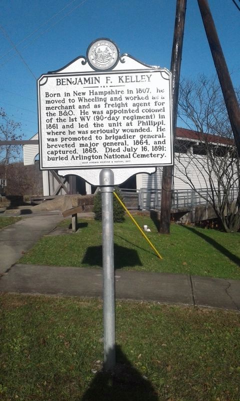
Born in New Hampshire in 1807, he moved to Wheeling and worked as a merchant and as a freight agent for the B&O. He was appointed colonel of the 1st WV (90-day regiment) in
1861 and led the unit at Philippi, where he was seriously wounded. He . . . — — Map (db m211566) HM
On June 2, 1861, Federal troops advanced on Philippi from the Baltimore & Ohio rail hub at Grafton in two columns of about 1500 men each. The left column, under Col. Benjamin Kelley, took the train six miles east to Thornton, and then marched . . . — — Map (db m211560) HM
“Big Apple Time Capsule”
Dedicated: Oct 19, 1990 – Re-open in year of 2040
Sponsor: Martinsburg Jaycees
This “community pride project” is an attempt to preserve the Apple Capital city and surrounding areas of . . . — — Map (db m1212) HM
The roundhouse is the sole surviving cast-iron framed roundhouse and is an important example of mid-19th century industrial building design. Designed by Albert Fink, in collaboration with Benjamin H. Latrobe, it represents an early use of . . . — — Map (db m1199) HM
National Civil Engineering Landmark. The re-construction of the Baltimore and Ohio Railroad Roundhouse and Shop Complex commenced soon after the end of the American Civil War in 1865. This complex included two roundhouses and two significant . . . — — Map (db m167682) HM
Founded, 1778, by Gen. Adam Stephen. Named for Thomas Martin, nephew of Lord Fairfax. Home of Admirals Charles Boarman and C.K. Stribling. Locomotives seized here, 1861, in Jackson’s raid were drawn by horses to Winchester, Va. — — Map (db m1973) HM
In April 1861, as the Civil War erupted, Confederate forces seized the Baltimore and Ohio Railroad from Harpers Ferry west. On May 24, Gen. Joseph
E. Johnston ordered Col. Thomas J. (later “Stonewall”) Jackson to destroy
the rolling . . . — — Map (db m149430) HM
Roundhouses and Shops. The B&O Railroad reached Martinsburg in 1842,
and by 1849, a roundhouse and shops were
built. These first buildings were burned by
Confederate troops in 1862. The present west
roundhouse and the two shops were built . . . — — Map (db m1197) HM
Looking Upstream and Northeast at the Colonnade Bridge, Circa 1860
In 1849, the Baltimore and Ohio established its railroad shops in Martinsburg and erected here two most noteworthy roundhouses and workshop buildings. The B&O erected a . . . — — Map (db m148872) HM
Built in the mid-1870s by Philip Showers, who owned the adjacent stone house (the Adam Stephen House) at that time, the Triple Brick Building was listed in early tax records as the "Tribble (Triple) House" or "the brick house divided into . . . — — Map (db m132401) HM
Dr. Allen C. Hammond constructed this Greek Revival-style house about 1838. During the Civil War, both sides used it periodically for a headquarters or a hospital. The war ruined Hammond, a strong Southern sympathizer.
In October 1859, . . . — — Map (db m154839) HM
Frontier Army Scout and Indian fighter Supplied buffalo meat to Kansas Pacific Railroad.
In 1883 he presented a Wild West Show.
A Sioux Warrior named Iron Tail was in the Cody Wild West Show-whose face is on the buffalo nickle. . . . — — Map (db m228318) HM
B&O Railroad Depot. Passenger station completed 1887, freighthouses 1890 with additions 1898, 1911 & 1916. B&O, oldest U.S. line, acquired in 1901. Superior location in business district gave B&O edge over C&O in city.
Heritage Village. . . . — — Map (db m213392) HM
The 1308, built in 1949, was one of the last working steam locomotives built by Baldwin Locomotive Works for a Class 1 railroad in the USA. It primarily hauled coal from Logan Co. Retired from C&O Railway service in 1956. Moved in September 1962 to . . . — — Map (db m60349) HM
Built by American Locomotive Company in 1924, the #10 was used to haul mine waste from Rich Run Mine in Widen, WV. Retired from Elk River Coal and Lumber in 1959 and moved to its present location on May 27, 1977. Placed on National Register of . . . — — Map (db m62334) HM
Originally called Holderby’s Landing. Laid out as a town, 1869, by Collis P. Huntington of the C&O Railroad, and named for him when incorporated in 1871. Western end of C&O when the first trains came from Richmond in 1873. — — Map (db m126030) HM
One of the original 7 US Bureau of
Mines train cars was headquartered
near C&O tracks, 1911–1933. The
wooden car, with crew & supplies,
traveled the WV region to give
mine safety & rescue training and
to aid in mine disaster rescue
efforts. . . . — — Map (db m126017) HM
To east was Claude Markle (1882-1962) home, noted road builder in Clay, Webster, Boone, & Kanawha in early 20th century. Projects include Maysel intersection of US 119/36/ & 4, Clay Jct. Route 16, & Widen ridge; bridges; tunnels; & culverts. He . . . — — Map (db m137966) HM
William Nelson Page became one of the leading managers and developers of West Virginia's coalfields in the late 19th and early 20th centuries, with much of his time being spent here in Ansted. While president of the Gauley Mountain Coal Company, . . . — — Map (db m173338) HM
Mining towns sprang up along the
banks of the New River when, in 1873,
the Chesapeake & Ohio Railway created
a pathway for transportation through the
region. Thurmond, Kaymoor, Nuttallburg,
Fayette, and other communities formed due
to the . . . — — Map (db m165210) HM
The gorge, like all
environments, is continually
changing. Change peaked in
the late 1800s when logging,
mining, and the railroad
converged to play a vital role
in the industrialization of the
United States. By the 1960s,
industrial . . . — — Map (db m165213) HM
This tight workspace (bench) was carved out of the mountainside to support the movement of mined coal. From 1899 to 1962, thousands of miners and over 16 millions tons of coal passed through these drift mine openings along this edge. With space at a . . . — — Map (db m242497) HM
On opposite sides of the New River, the twin mining towns of Fayette and South Fayette were established along the tracks of the Chesapeake & Ohio Railway. The company town of Fayette provided miners with housing, a company store, a school, post . . . — — Map (db m179372) HM
In the early 1900s, over 80 coal mines and towns lined this gorge and were connected by the Chesapeake & Ohio (C&O) Railway. Freight trains ran every 15 minutes and a dozen passenger trains ran daily during those busy times. The area's industrial . . . — — Map (db m243360) HM
You may find it hard to believe that the New River Gorge was once teeming with activity. Coal mining dominated the economy and social structure of the state of West Virginia between 1875 and 1950. During this time over forty coal mining towns were . . . — — Map (db m165274) HM
In the early 1900’s, mines and mining towns lined New River Gorge. One such town, Kaymoor, stood in the distance where the river disappears from view. Kaymoor typified New River’s mining era.
For years New River Gorge’s rugged remoteness defied . . . — — Map (db m99988) HM
Notice the tree-covered slopes of the Gorge—they are not as they appear.
From here the solid forest cover from riverbottom to ridgetop all looks pretty much the same, but, a close look reveals great differences. The forest varies with slope, . . . — — Map (db m99980) HM
As Mt. Hope emerged, there occurred one of the most important events in the state's history: the Chesapeake & Ohio Railroad, routed through the New River Gorge, was completed in 1873. The C&O was the first railroad to enter southern West Virginia . . . — — Map (db m242622) HM
The railroad track in front of you is the C&O Railway's main line. Without the railroad, there would have been no Nuttallburg. By carrying coal to market, the railroad made coal mining in New River Gorge possible. John Nuttall came here in 1870 to. . . . — — Map (db m242438) HM
Built in 1903 by the White Oak Railway Company, the depot is one of the oldest surviving structures in the community. It was leased by the Virginian Railway Company in 1912, then purchased in 1922, and is the only extant Virginian depot in West . . . — — Map (db m143111) HM
The Chesapeake & Ohio (C&O) Railway mainline was Thurmond's main street, the
core of this town's identity. As one of the busiest centers of activity in this region of coal commerce, Thurmond was the only place in a 73-mile stretch where . . . — — Map (db m165257) HM
Thurmond ran from the river's edge up the hill. Homes dotted the hillside. Large businesses (like Hotel Thurmond and Armour Meat Company) along with small shops
(a jeweler, shoemaker, barber, and others) served the needs of residents and . . . — — Map (db m165248) HM
The first bridge here was for trains. Built in 1889, it provided a critical link between the Chesapeake & Ohio (C&O) Railway mainline in Thurmond and the many coal mines and communities scattered throughout the gorge. The original bridge was . . . — — Map (db m242507) HM
As access to places outside the gorge improved, Thurmond's importance declined. Area coal mines also declined in productivity. The most significant changes, however, came by 1949 when the nation's railroad industry had switched from steam to . . . — — Map (db m165249) HM
A major use of coal was as fuel for steam trains. Coal was used to heat the water in the boiler of each locomotive, making steam that powered the train engines. As one of the few places in the gorge where locomotives could be refueled, the . . . — — Map (db m165246) HM
New River Gorge National River offers beautiful scenery and much more. The park features the geology of one of the world's
oldest rivers and preserves the natural and cultural diversity of a land once exploited by industry. Today New River Gorge is . . . — — Map (db m165244) HM
You are now in the heart of downtown Thurmond. In 1913 the Fayette Journal called Thurmond the “Biggest Little Town.” Today it is difficult to imagine why. Just three buildings survive from Thurmond’s once-thriving commercial district. . . . — — Map (db m242510) HM
The rails that you see here symbolize Thurmond’s essence—the railroad. These rails were truly Thurmond’s main street. Coal was king, but was worthless if it couldn’t get to market. Workers in Thurmond’s engine house kept the C&O Railway’s coal . . . — — Map (db m242511) HM
The Chesapeake and Ohio (C&O) Railway built this depot in 1904 to manage passengers and freight—mostly coal. This building replaced an earlier depot that burned the year before. The railroad was the only practical way in and out of New River . . . — — Map (db m242512) HM
Ribbons of steel were, and still are, the main street of Thurmond. For over 80 years, trains were the primary method of travel, linking over 50 New River communities to each other and connecting the gorge to the rest of the US. Thurmond was a . . . — — Map (db m165243) HM
Here in Thurmond you can recall the vital role that railroads played in the growth and prosperity of America. For more than 80 years Thurmond’s railroads thrived. Amid the remnants of this once-bustling town, you can imagine the sounds of steam . . . — — Map (db m242508) HM
Look down the railroad tracks. You might see a train coming. But if you do, you won’t see an engine fueled by coal, belching smoke and steam, as you would have during Thurmond’s heyday. Instead, you will see an engine powered with diesel fuel. . . . — — Map (db m242509) HM
This depot was the heart of Thurmond and the New River Gorge in the early 1900s. The railroad ruled transportation, and this station is where people began their business and social activities when they arrived. Chesapeake & Ohio (C&O) Railway . . . — — Map (db m217544) HM
On April 20, 1863, Confederate Gens. William E. "Grumble" Jones and John D. Imboden began a raid on the Baltimore and Ohio Railroad from Virginia through present-day West Virginia. Taking separate routes, they later reported that they . . . — — Map (db m178393) HM
Earthworks and other remnants of Union Capt. James A. Jarboe's blockhouse are located nearby, where Jarboe's Co. I, 10th West Virginia Infantry, guarded the Morgantown and Patterson Creek roads intersection. The company also escorted the supply . . . — — Map (db m178391) HM
This house is one of the original company homes built by the tannery in Petersburg. It was part of a row of ten houses, all painted yellow, which were rented to tannery employees at a reduced rate of $3.00 a month. Each house had five rooms and . . . — — Map (db m162728) HM
Caldwell on Scribner's Magazine Cover
Caldwell, located two and a half miles east of Lewisburg, gets its name from James R. Caldwell, whose family owned and occupied the stately brick house, "Elmhurst," on the bank of the Greenbrier River. . . . — — Map (db m238237) HM
Meadow River Lumber CompanyEstablished as Raine-Andrew Lumber Co. concern with purchase of 32,000 ac. (1906-08) by John & Tom Raine, namesake of Rainelle, founded 1908. Used logging railroad from woods to mill & Sewell Valley RR (NF&G) to C&O. . . . — — Map (db m50391) HM
On June 13, 1861, Col. Lew Wallace (11th Indiana Infantry) led a raid against Southern forces occupying Romney. Wallace passed through the Mechanicsburg Gap and took South Branch Bridge. The Rebel retreat from Romney forced Gen. Johnston to abandon . . . — — Map (db m150660) HM
Romney in 1861–1865. Sitting astride the natural invasion route from the Shenandoah Valley to the Potomac and the B. & O. Railroad, Romney was scourged by both armies. No great battles were fought here, but during the War the town . . . — — Map (db m159297) HM
Named for natural springs reputedly used by George Washington. Donated in 1857 for picnics and prize fights. Developed in 1897 as amusement park served by streetcar and boat attracting 15-20 thousand daily. Included dance pavilions, shooting . . . — — Map (db m49697) HM
Born in Hollidays Cove ca. 1829. Moved to Kentucky and served as Union civilian scout during the Civil War. Seized locomotive, The General, in northern Georgia, and attempted to move within Union lines, but train lost power and raiders were . . . — — Map (db m155989) HM
Built 1892, following the completion of railroad in 1887. Lost Creek grew to become largest shipping point for cattle in West Virginia in 1915 and on entire B & O system, east of Mississippi in 1923. — — Map (db m35331) HM
Constructed in 1912, this depot served on the
transcontinental railway, with its last passing train
in 1985. The depot was restored in the 1990's by
citizens of the Salem area. The project was funded
through the Intermodal Surface . . . — — Map (db m170859) HM
The B&O Railroad constructed this 6-sided communications booth at the Ehelen-Solon siding, near the Vincent Lumber Company, as part of its private phone rail
communications system. A booth operator could call from one of 10 sidings between . . . — — Map (db m177416) HM
Passengers in the late 1800s would have instantly recognized this building as the Baltimore and Ohio (B&O) Railroad station. Known for their distinctive style and red-and-brown color scheme, the B&O designed their stations to give customers a . . . — — Map (db m70782) HM
Situated in a gap of the Blue Ridge Mountains and at the confluence of the Shenandoah and Potomac Rivers, Harpers Ferry, from its beginning, functioned as a natural avenue of transportation.
The first mode of travel consisted of a primitive . . . — — Map (db m12058) HM
Serious problems plagued the weapons stored in this two-story structure built in 1799. Floods and high humidity posed constant threats. Sparks from wood-burning locomotives presented a fire hazard. Inadequate storage space caused overcrowding and . . . — — Map (db m18691) HM
On this spot in 1838 the Baltimore and Ohio Railroad (B&O) pulled into the lead in the race for transportation industry dominance with the Chesapeake & Ohio Canal (C&O). Denied across to the Maryland side of the river, the B&O struck a deal with the . . . — — Map (db m23415) HM
The B&O Railroad constructed this embankment in the 1890s, covering a large section of the original armory site and elevating their train tracks above flood levels. — — Map (db m143945) HM
Trains clanking along iron rails have echoed through Virginius Island since the Winchester & Potomac Railroad arrived here in 1836. It extended from the Baltimore & Ohio Railroad junction at Harpers Ferry 32 miles southward to Winchester. The W&P . . . — — Map (db m18981) HM
Work on the railroad and canal progressed slowly at first, but by 1834 both companies had completed construction to a point opposite Harpers Ferry. The canal had won the race to this point and it continued up the Maryland side of the Potomac. . . . — — Map (db m12062) HM
As the railroad streaked westward from Harpers Ferry, the C&O Canal fell hopelessly behind in the race for Ohio. Burdened by a lack of building supplies and a scarcity of skilled labor, the canal encountered serious financial problems and did not . . . — — Map (db m12064) HM
Rail transportation in the United States began in Baltimore, Maryland on July 4, 1828, when Charles Carroll, the only living signer of the Declaration of Independence, laid the cornerstone of the Baltimore and Ohio Railroad.
On the same day . . . — — Map (db m12060) HM
This station structure was erected in 1839 by landowner Richard Duffield, in cooperation with the Baltimore & Ohio Railroad. It is the oldest surviving purpose-built freight/passenger rail station in the United States, and is listed on the . . . — — Map (db m157741) HM
The Federal offensive in the Shenandoah Valley begun in May 1864 faltered in the summer with Confederate victories and Gen. Jubal A. Early's Washington Raid in July. Union Gen. Philip H. Sheridan took command in August, defeated Early at . . . — — Map (db m206976) HM
Charleston's population tripled in the early 20th century to 67,914 residents by 1940. Rapid expansion brought serious growing pains, as ever-increasing numbers of cars, buses and trucks clogged city streets and created paralyzing gridlock. The . . . — — Map (db m229187) HM
Davis Park was originally developed in 1906 by former U.S. Senator Henry Gassaway Davis (1823-1916). Senator Davis was a self-made millionaire successful in the rail, mining and banking industries. He was elected to the U.S. Senate from West . . . — — Map (db m232885) HM
According to legend, John Henry's profession as a steel-driver was measured in a race against a steam powered hammer, which he won, only to die in victory with his hammer in his hand as his heart gave out from stress. — — Map (db m228844) HM
1776 Waterpowered "sash" sawmill, Tucker County
1830's Steam powered circular saws first used
1860 Portable steam sawmills, first used
1871 C&O sawmill opened, St. Albans, Kanawha County
1875 Band sawmill . . . — — Map (db m178836) HM
Armor-plated train used against striking miners during the Paint
Creek-Cabin Creek Strike. On February 7, 1913, coal operator Quin Morton, Sheriff Bonner Hill, and several railroad men and deputies, armed with rifles and machine gun, rode train . . . — — Map (db m137833) HM
Hale's Emporium, owned by Presley Hale, clothing
provider, and ardent Unionist. Consequently, Confederate
raiders frequently relieved Mr. Hale of his inventory during
the Civil War.
Numerous attempts were made to bring rail to Weston
since . . . — — Map (db m204103) HM
On April 20, 1863, Confederate Gens. William E. "Grumble" Jones and John D. Imboden began a raid from Virginia through present-day West Virginia on the Baltimore and Ohio Railroad. Taking separate routes, they later reported that they marched 1,100 . . . — — Map (db m155501) HM
221 entries matched your criteria. The first 100 are listed above. Next 100 ⊳