After filtering for North Carolina, 530 entries match your criteria. Entries 101 through 200 are listed.⊲ Previous 100 — Next 100 ⊳
Churches & Religion Topic
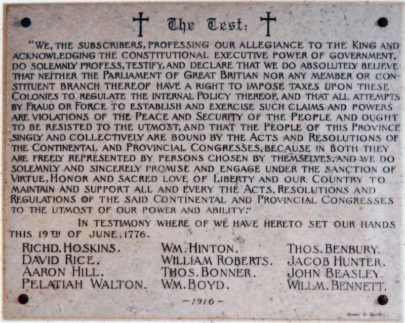
Marker detail: “The Test”
| 101 ► North Carolina, Chowan County, Edenton — 12 — 1736 St. Paul's Episcopal Church — Parish Organized under Act of Assembly 1701 — Edenton Historical Commission Museum Trail — |
| On West Church Street just west of North Broad Street (State Highway 32), on the right when traveling west. | |||
| 102 ► North Carolina, Chowan County, Edenton — 11 — 1897 Kadesh A.M.E. Zion Church — Edenton Historical Commission Museum Trail — |
| On East Gale Street east of North Broad Street (State Highway 32), on the left when traveling east. | |||
| 103 ► North Carolina, Chowan County, Edenton — 4 — Dr. Hugh Williamson (1735 - 1819) — Signer of The Constitution of the United States of America — A True Renaissance Man — |
| On East Water Street east of Court Street, on the right when traveling east. | |||
| 104 ► North Carolina, Chowan County, Edenton — Dr. Martin Luther King, Jr. in Edenton, 1962 — |
| On North Broad Street (North Carolina Route 32) just south of Park Avenue, on the left when traveling south. | |||
| 105 ► North Carolina, Chowan County, Edenton — Edenton United Methodist Church — |
| On North Broad Street (State Highway 32) north of East Church Street, on the right when traveling north. | |||
| 106 ► North Carolina, Chowan County, Edenton — Joseph Hewes — |
| On East Water Street just west of Court Street, on the right when traveling west. | |||
| 107 ► North Carolina, Chowan County, Edenton — A-1 — St Paul's Episcopal Church |
| On North Broad St north of West Church Street, on the left when traveling north. Reported missing. | |||
| 108 ► North Carolina, Chowan County, Edenton — St. John's Episcopal School / Church of St. John the Evangelist — |
| On East Church Street (North Carolina Route 32) west of South Oakum Street, on the left when traveling west. | |||
| 109 ► North Carolina, Chowan County, Edenton — A-1 — St. Paul's Episcopal Church — |
| On North Broad Street north of West Church Street, on the left when traveling north. | |||
| 110 ► North Carolina, Chowan County, Edonton — St. Paul's Episcopal Church — |
| On North Broad Street (State Highway 32) just north of West Church Street, on the left when traveling north. | |||
| 111 ► North Carolina, Clay County, Hayesville — Q-37 — George W. Truett — |
| On Hiawasee Street (Business U.S. 64) at Pass Street, on the right when traveling north on Hiawasee Street. | |||
| 112 ► North Carolina, Cleveland County, Polkville — O-75 — Mount Harmony United Methodist Church — |
| On Polkville Road (State Highway 226) at Mt. Harmony Church Road (County Road 1379), on the right when traveling north on Polkville Road. | |||
| 113 ► North Carolina, Cleveland County, Shelby — O-72 — Thomas Dixon, Jr. — 1864-1946 — |
| On West Marion Street at North Martin Sreet, on the right when traveling west on West Marion Street. | |||
| 114 ► North Carolina, Cleveland County, Shelby — World War II Memorial — |
| On North Lafayette Street (State Highway 18) just north of Campbell Street, on the right when traveling north. | |||
| 115 ► North Carolina, Columbus County, Tabor City — Mt. Tabor — |
| On East 5th Street (Business U.S. 701) at Pireway Road (North Carolina Highway 904), on the right when traveling south on East 5th Street. | |||
| 116 ► North Carolina, Craven County, New Bern — Centenary United Methodist Church — |
| On New Street just east of Middle Street. | |||
| 117 ► North Carolina, Craven County, New Bern — C-42 — Christ Church — |
| On Broad Street (Business U.S. 17) at Craven Street, on the right when traveling east on Broad Street. | |||
| 118 ► North Carolina, Craven County, New Bern — Ebenezer Presbyterian Church — 1880-1992 — |
| On Queen Street at Pasteur Street, on the left when traveling east on Queen Street. | |||
| 119 ► North Carolina, Craven County, New Bern — First House of Worship of Colonial Craven Parish — |
| On Pollock Street at Middle Street, on the right when traveling west on Pollock Street. | |||
| 120 ► North Carolina, Craven County, New Bern — First Presbyterian Church — |
| On New Street at Middle Street, on the right when traveling west on New Street. | |||
| 121 ► North Carolina, Craven County, New Bern — 228 — First Presbyterian Church — American Presbyterian and Reformed Historical Site — |
| On New Street, on the right when traveling west. | |||
| 122 ► North Carolina, Craven County, New Bern — C-33 — James Walker Hood — |
| On Broad Street (U.S. 17) at George Street, on the right when traveling west on Broad Street. | |||
| 123 ► North Carolina, Craven County, New Bern — Rev. John Knox Witherspoon — Educator & Minister — 1817 — |
| On New Street just west of Middle Street, on the right when traveling west. | |||
| 124 ► North Carolina, Craven County, New Bern — St. Peter's A.M.E. Zion Church — |
| On Queen Street at George Street, on the right when traveling east on Queen Street. | |||
| 125 ► North Carolina, Craven County, New Bern — William Henry Singleton — From Slavery to Freedom — |
| On Queen Street near Johnson Street. | |||
| 126 ► North Carolina, Cumberland County, Fayetteville — Cross Creek Linear Park — Our Pathway to the Future — |
| 127 ► North Carolina, Cumberland County, Fayetteville — First Presbyterian Church — |
| On Person Street at Bow Street, on the right when traveling west on Person Street. | |||
| 128 ► North Carolina, Cumberland County, Fayetteville — I-28 — First Presbyterian Church — |
| On Green Street at Bow Street / Maiden Lane, on the left when traveling north on Green Street. | |||
| 129 ► North Carolina, Cumberland County, Fayetteville — I-62 — Henry Evans — |
| On Person Street at Cool Spring Street, on the right when traveling west on Person Street. | |||
| 130 ► North Carolina, Cumberland County, Fayetteville — I-79 — John England — 1786 - 1842 — |
| On Village Drive at Owen Drive, on the right when traveling west on Village Drive. | |||
| 131 ► North Carolina, Cumberland County, Fayetteville — I-13 — MacPherson Church — |
| On South MacPherson Church Road near Raeford Road (Business U.S. 401), on the left when traveling south. | |||
| 132 ► North Carolina, Cumberland County, Fayetteville — I-55 — Methodist University — |
| On Ramsey Street (U.S. 401) at Lowdermilk Drive, on the right when traveling north on Ramsey Street. | |||
| 133 ► North Carolina, Cumberland County, Fayetteville — I-89 — Omar Ibn Said — |
| On Murchison Road just south of Patina Court. | |||
| 134 ► North Carolina, Cumberland County, Fayetteville — Saint Patrick Catholic Church — |
| On Village Drive at Bryn Mawr Drive, on the left when traveling east on Village Drive. | |||
| 135 ► North Carolina, Cumberland County, Godwin — I-1 — Old Bluff Church — |
| On Dunn Road (U.S. 301) at Sisk Culbreth Road, on the left when traveling north on Dunn Road. | |||
| 136 ► North Carolina, Cumberland County, Grays Creek — I-59 — Dunn’s Creek Quaker Meeting — |
| On State Highway 87 at Butler Nursery Rd (Local Route 2221), on the right when traveling north on State Highway 87. | |||
| 137 ► North Carolina, Cumberland County, Hope Mills — I-27 — Cape Fear Baptist Church — |
| On State Highway 87 at Blossom Road (Local Route 2234), on the right when traveling north on State Highway 87. | |||
| 138 ► North Carolina, Cumberland County, Linden — I-52 — Rev. James Campbell — |
| On Ramsey Street (U.S. 401) at East Reeves Bridge Road, on the right when traveling north on Ramsey Street. | |||
| 139 ► North Carolina, Cumberland County, Wade — Old Bluff Church — The Muddy Road to Averasboro — Carolinas Campaign — |
| On Old Bluff Church Road, 1 mile west of Sisk Culbreth Road, on the right when traveling west. | |||
| 140 ► North Carolina, Currituck County, Corolla — Corolla Chapel — |
| On Corolla Village Road at Persimmon Street, on the left when traveling north on Corolla Village Road. | |||
| 141 ► North Carolina, Currituck County, Moyock — A-59 — Joseph Pilmoor — |
| On Caratoke Highway (Route 168) at Courthouse Road (North Carolina Highway 1242) on Caratoke Highway. | |||
| 142 ► North Carolina, Dare County, Manteo — B-44 — Andrew Cartwright — |
| On North Virginia Dare Avenue (U.S. 64/264) at Russel Twiford Road, on the right when traveling west on North Virginia Dare Avenue. | |||
| 143 ► North Carolina, Davidson County, Lexington — Beck's Reformed Church — |
| On Becks Church Road, 0.2 miles north of Homestead Drive, on the right when traveling north. | |||
| 144 ► North Carolina, Davidson County, Lexington — Captain Peter Hedrick — Dec. 17, 1733 – Jan. 24, 1798 — |
| On Becks Church Road, 0.2 miles north of Homestead Drive, on the right when traveling north. | |||
| 145 ► North Carolina, Davidson County, Lexington — First Reformed Church — |
| On North Salisbury Street north of East Center Street, on the left when traveling north. | |||
| 146 ► North Carolina, Davidson County, Lexington — First Site of Pilgrim Reformed Church — |
| Near Pilgrim Church Road, 0.2 miles west of City Lake Road, on the right when traveling west. | |||
| 147 ► North Carolina, Davidson County, Lexington — K-49 — Pilgrim Church — |
| On Greensboro Street Extension at Ridge Road, on the right when traveling west on Greensboro Street Extension. | |||
| 148 ► North Carolina, Davidson County, Lexington — St. Stephen United Methodist Church — Est. 1868 — |
| On East 1st Street at North Salisbury Street, on the right when traveling west on East 1st Street. | |||
| 149 ► North Carolina, Davidson County, Thomasville — K-32 — John H. Mills |
| On U.S. 70, 0.3 miles south of Shuler Road, on the right when traveling north. Reported missing. | |||
| 150 ► North Carolina, Davidson County, Thomasville — Mitchell House — |
| On Biggs Avenue, 0.1 miles south of West Main Street, on the left when traveling south. | |||
| 151 ► North Carolina, Davie County, Advance — M-44 — Cokesbury School — |
| On Route 801, 0.2 miles south of Cornatzer Road, on the right when traveling north. | |||
| 152 ► North Carolina, Davie County, Mocksville — In 1827 — |
| Near Yadkinville Road (U.S. 601). | |||
| 153 ► North Carolina, Duplin County, Kenansville — Grove Academy — |
| On North Carolina Route 11/903 north of James Sprunt Drive, on the right when traveling north. | |||
| 154 ► North Carolina, Duplin County, Kenansville — F-4 — Grove Church — |
| On South Main Street south of Stokes Street, on the left when traveling south. | |||
| 155 ► North Carolina, Durham County, Bahama — G-65 — Mount Bethel Methodist Church — |
| On Bahama Road (North Carolina Route 1616) east of Stagville Road (North Carolina Route 1615), on the right when traveling east. | |||
| 156 ► North Carolina, Durham County, Durham, City Center — A Legacy of Community and Institutional Connections — |
| On West Orange Street north of West Parrish Street, on the right when traveling north. | |||
| 157 ► North Carolina, Durham County, Durham, City Center — Emanuel J. Evans, 1907-1997, and Sara N. Evans, 1905-1986 — |
| On West Main Street west of Market Street. | |||
| 158 ► North Carolina, Durham County, Durham, Downtown — 12 — St. Philip's Episcopal Church — 1907 — Historic Preservation Society of Durham — |
| On East Main Street east of North Queen Street, on the right when traveling west. | |||
| 159 ► North Carolina, Durham County, Durham, North Carolina Central University — Centennial Chapel — North Carolina Central University Historical Marker — |
| On Fayetteville Street north of Formosa Avenue, on the right when traveling south. | |||
| 160 ► North Carolina, Durham County, Durham, Trinity Park — 112 — The King's Daughters Home — |
| On North Buchanan Boulevard at 16 Alley, on the left when traveling south on North Buchanan Boulevard. | |||
| 161 ► North Carolina, Durham County, Durham, West End — Impact — |
| On Carroll Street north of Morehead Avenue, on the left when traveling north. | |||
| 162 ► North Carolina, Durham County, Durham, West End — G-48 — Pauli Murray — 1910-1985 — |
| On West Chapel Hill Street at Carroll Street, on the right when traveling west on West Chapel Hill Street. | |||
| 163 ► North Carolina, Edgecombe County, Tarboro — E-85 — John C. Dancy — 1857 ~ 1920 — |
| On West St. James Street near Main Street (Business U.S. 64). | |||
| 164 ► North Carolina, Edgecombe County, Tarboro — St. Paul A.M.E. Zion Church — Historical Marker — |
| On East Granville Street near St. David Street, on the right when traveling east. | |||
| 165 ► North Carolina, Forsyth County, Bethania — Alpha Chapel — constructed 1895 — |
| Near Bethania Road. | |||
| 166 ► North Carolina, Forsyth County, Bethania — Bethania — Founded 12 June 1759 — |
| On Bethania Road, 0.1 miles east of Main Street, on the left when traveling west. | |||
| 167 ► North Carolina, Forsyth County, Bethania — Bethania — Established 1759 — |
| Near Bethania Road. | |||
| 168 ► North Carolina, Forsyth County, Clemmons — J-66 — McKnight's Meeting House — |
| On U.S. 158, on the right when traveling east. | |||
| 169 ► North Carolina, Forsyth County, Clemmons — J-110 — Wachovia Tract — |
| On South Stratford Road (U.S. 158) at Bryn Mawr Lane (North Carolina Highway 1115), on the right when traveling east on South Stratford Road. | |||
| 170 ► North Carolina, Forsyth County, Lewisville — Concord United Methodist Church — |
| On Concord Church Road, on the right when traveling west. | |||
| 171 ► North Carolina, Forsyth County, Lewisville — Lewisville Baptist Church — Established 1881 — Lewisville's First Organized Baptist Church — |
| On Lewisville Clemmons Road, on the right when traveling north. | |||
| 172 ► North Carolina, Forsyth County, Lewisville — Lewisville United Methodist Church — Establised 1878 — |
| On Shallowford Road at Lewisville Vienna Road, on the right when traveling east on Shallowford Road. | |||
| 173 ► North Carolina, Forsyth County, Lewisville — Methodist Church Parsonage — |
| On Shallowford Road, on the right when traveling east. | |||
| 174 ► North Carolina, Forsyth County, Lewisville — New Hope AME Zion Church — 1883 — Date of Deed — |
| On Shallowford Road at Tuscany Drive, on the left when traveling north on Shallowford Road. | |||
| 175 ► North Carolina, Forsyth County, Lewisville — Shiloh Lutheran Church — |
| On Lewisville Vienna Road, on the right when traveling north. | |||
| 176 ► North Carolina, Forsyth County, Oldtown — Bethabara — Historic Bethabara Park • 1753 — |
| On Bethabara Road east of Bethania Station Road, on the right when traveling east. | |||
| 177 ► North Carolina, Forsyth County, Oldtown — Gemeinhaus 1756 — |
| Near Bethabara Road, on the right when traveling east. | |||
| 178 ► North Carolina, Forsyth County, Pfafftown — Brookstown United Methodist Church — Established 1853 — |
| On Yandkinville Road, on the left when traveling west. | |||
| 179 ► North Carolina, Forsyth County, Rural Hall — J-51 — Nazareth Church — |
| On Bethania Rural Hall Road at Tobaccoville Road, on the left when traveling north on Bethania Rural Hall Road. | |||
| 180 ► North Carolina, Forsyth County, Winston-Salem — Davy House (1835) — Archaeological Site — Old Salem Museums & Gardens — |
| On South Church Street south of East Bank Street, on the right when traveling north. | |||
| 181 ► North Carolina, Forsyth County, Winston-Salem — Dr. Martin Luther King, Jr. — |
| Near 4th Street East at North Dunleith Avenue, on the right when traveling west. | |||
| 182 ► North Carolina, Forsyth County, Winston-Salem — Emancipation in Salem — "Henceforward Shall Be Free" — |
| Near South Church Street just north of Race Street, on the left when traveling south. | |||
| 183 ► North Carolina, Forsyth County, Winston-Salem — First Baptist Church — |
| On North Chestnut Street just north of East 6th Street, on the right when traveling north. | |||
| 184 ► North Carolina, Forsyth County, Winston-Salem — J-65 — Fraternity Church of the Brethren — |
| On South Stratford Road (U.S. 158) at Fraternity Church Road, on the right when traveling east on South Stratford Road. | |||
| 185 ► North Carolina, Forsyth County, Winston-Salem — J-63 — Friedberg Church — |
| On Peters Creek Parkway (U.S. 150) at Friedberg Church Road, on the right when traveling south on Peters Creek Parkway. | |||
| 186 ► North Carolina, Forsyth County, Winston-Salem — 4 — Gemeinhaus — 1788 — |
| On Bethabara Rd., on the left when traveling north. | |||
| 187 ► North Carolina, Forsyth County, Winston-Salem — Happy Hill Overlook — |
| Near South Church Street just north of Race Street, on the left when traveling south. | |||
| 188 ► North Carolina, Forsyth County, Winston-Salem — Historic Happy Hill Path — |
| Near South Church Street just north of Race Street, on the left when traveling south. | |||
| 189 ► North Carolina, Forsyth County, Winston-Salem — Home Moravian Church — |
| On South Church Street just north of East Academy Street, on the right when traveling north. | |||
| 190 ► North Carolina, Forsyth County, Winston-Salem — Last Burials in the Parish Graveyard — |
| On South Church Street just north of Race Street, on the right when traveling north. | |||
| 191 ► North Carolina, Forsyth County, Winston-Salem — Lewis Hege (1840-1918) — African American Heritage Site — Old Salem Museums & Gardens — |
| On Race Street at Church Street South, on the left when traveling west on Race Street. | |||
| 192 ► North Carolina, Forsyth County, Winston-Salem — Lloyd Presbyterian Church — |
| On N. Chestnut St., 0.1 miles north of E. 7th St., on the left when traveling north. | |||
| 193 ► North Carolina, Forsyth County, Winston-Salem — New Bethel Baptist Church — |
| On Trade Street NW north of 10th Street West. | |||
| 194 ► North Carolina, Forsyth County, Winston-Salem — Old Salem Historic District — |
| On South Main Street just south of East Academy Street, on the left when traveling south. | |||
| 195 ► North Carolina, Forsyth County, Winston-Salem — Pottery Kilns on Lot 38 — Archaeological Site — Old Salem Museums & Gardens — |
| On South Main Street, 0.1 miles East Bank Street, on the right when traveling north. | |||
| 196 ► North Carolina, Forsyth County, Winston-Salem — Reich-Hege House Site (1830-1922) — |
| On Race Street at Church Street South, on the left when traveling west on Race Street. | |||
| 197 ► North Carolina, Forsyth County, Winston-Salem — Rt. Rev. Edw. Rondthaler, D.D. — |
| On Church Street South just north of East Academy Street when traveling north. | |||
| 198 ► North Carolina, Forsyth County, Winston-Salem — Salem Moravian Graveyard — |
| 199 ► North Carolina, Forsyth County, Winston-Salem — Second House Site (1767) — Old Salem Museums & Gardens — 1766 — |
| On South Main Street near West Bank Street, on the right when traveling south. | |||
| 200 ► North Carolina, Forsyth County, Winston-Salem — Silver Hill — |
| On Holiday Street, 0.1 miles north of Carolina Circle, on the left when traveling north. | |||
530 entries matched your criteria. Entries 101 through 200 are listed above. ⊲ Previous 100 — Next 100 ⊳