By William Fischer, Jr., February 19, 2012
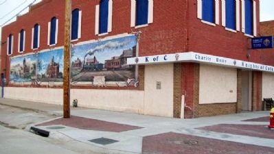
Kearney: From the Beginning Marker and Murals
GEOGRAPHIC SORT Title Sort Marker Number Sort Marker Number Sort N Marker Number Sort T Publication Order Sort Publication Order Sort A Erected Year Sort Most Viewed Sort Most Recent-Interest Sort Most Recently Changed Sort SEE FAQ #33 FOR DESCRIPTIONS
On Central Avenue at 19th Street, on the left when traveling north on Central Avenue.
On State Highway 2, 1 mile east of Ravenna Road (State Highway 68), on the right when traveling east.
On U.S. 20 at milepost 198, on the right when traveling west.
On Illinois Street (aka Lincoln Highway) (U.S. 30) at Ball Street, on the right when traveling east on Illinois Street (aka Lincoln Highway).
Near U.S. 77, 0.9 miles north of 225th Street, on the right when traveling north.
On U.S. 385 near U.S. 20.
Near Bridges to Buttes Byway (U.S. 20) 0.1 miles west of Soldier Creek Road, on the right when traveling west.
On Bridges to Buttes Byway (U.S. 20) near 3200 Bridges to Buttes Byway, on the right when traveling south.
Near Bridges to Buttes Highway (U.S. 20).
Near Bridges to Buttes Byway (U.S. 20) 0.1 miles south of Soldier Creek Road, on the right when traveling south.
Near U.S. 20, 0.5 miles north of U.S. 20.
Near Bridges to Buttes Byway (U.S. 20).
On McPhearson Street (U.S. 20) at State Highway 2, on the right when traveling east on McPhearson Street.
Near Bridges to Buttes Byway (U.S. 20) 0.2 miles south of Soldier Creek Road, on the left when traveling south.
On Old Smiley Scenic Road/Smiley Canyon Scenic Drive, 3 miles west of Bridges to Buttes Byway (U.S. 20), on the right when traveling west.
Paid Advertisement
Near Bridges to Buttes Byway (U.S. 20) 0.1 miles south of Soldier Creek Road, on the right when traveling south.
On Highway 20 (U.S. 20), on the right when traveling east.
Near Bridges to Buttes Byway (U.S. 20) south of Soldier Creek Road, on the right when traveling east.
On Bridges to Buttes Byway (U.S. 20) 0.1 miles south of Soldier Creek Road, on the right when traveling south.
Near Bridges to Buttes Byway (U.S. 20).
Near Bridges to Buttes Byway (U.S. 20) 0.1 miles south of Soldier Creek Road, on the right when traveling north.
Near Bridges to Buttes Byway (U.S. 20) just south of Soldier Creek Road, on the right when traveling west.
Near Bridges to Buttes Byway (U.S. 20) 0.1 miles south of Soldier Creek Road, on the right when traveling south.
On Bridges to Buttes Highway (U.S. 20) near Soldier Creek Road.
On 2nd Street at Main Street, on the right when traveling north on 2nd Street.
On Interstate 80 at milepost 99, on the right when traveling east.
On John J Pershing Dr at Hummel Rd, on the left when traveling north on John J Pershing Dr.
On Metro Tech College Road (West Road) at Metro Tech College Road (North Road), on the left when traveling north on Metro Tech College Road (West Road).
On Fort Avenue at North 30th Street (U.S. 75), on the right when traveling west on Fort Avenue.
On North Road, on the left when traveling west.
Paid Advertisement
On East Road at South Road, on the right when traveling north on East Road.
On East Road, on the right when traveling north.
On South Road, on the left when traveling west.
On West Road, on the right when traveling south.
On East Road, on the right when traveling north.
On West Road at Middle Road, on the left when traveling north on West Road.
On East Road, on the right when traveling north.
On West Road, on the right when traveling south.
On Middle Road, on the right when traveling west.
On Middle Street, on the left when traveling west.
On North Road, on the right when traveling west.
On the Alley between 2nd and 1st Roads, on the left when traveling north.
On West Road, on the left when traveling north.
On East Road, on the right when traveling north.
On State Highway 18, 0.8 miles west of Wellington Street, on the left when traveling west.
Near Dam Road (State Highway 96) 7 miles north of State Highway 91, on the left when traveling north.
Paid Advertisement
On Nebraska Route 91/11, 0.3 miles east of Windy Hill Road, on the right when traveling east.
On Locust Street near 1st Street (U.S. 30), on the left when traveling south.
On River Road, 4 miles north of U.S. 136, on the right when traveling north.
On State Highway 50A at 27th Road, on the left when traveling east on State Highway 50A.
Near V Road (State Highway 50A) at Road 29.
On 25th Road (Nebraska Route 44) 0.1 miles south of W Road, on the left when traveling south.
On Interstate 80, 5.3 miles west of State Highway 560, on the right when traveling west.
On U.S. 30 at South Jackson Road, on the left when traveling east on U.S. 30.
Near North Buffalo Bill Avenue, 0.8 miles north of Lincoln Highway (U.S. 30), on the right when traveling north.
Near North Buffalo Bill Avenue, 0.8 miles north of Lincoln Highway (U.S. 30), on the right when traveling north.
Near North Buffalo Bill Avenue, 0.8 miles north of Lincoln Highway (U.S. 30), on the right when traveling north.
Near North Buffalo Bill Avenue, 0.8 miles north of Lincoln Highway (U.S. 30), on the right when traveling north.
On 4th Corso (Nebraska Route 2) 0.2 miles west of South 19th Street, on the right when traveling west.
Near Old Oregon Trail Road (State Highway 92).
On Nebraska Route 92 at Hunt Dairy Road, on the right when traveling east on State Route 92.
On Old Oregon Trail Road near Nebraska Highway 92, on the left when traveling north.
Paid Advertisement
On U.S. 75 at Monroe Street, on the left when traveling north on U.S. 75.
Near Madison St, 0.8 miles east of U.S. 75.