Established as the post of Beaver, May 15, 1872, by the 8th U.S. Infantry, Major John D. Wilkins, commanding. The military reservation, declared May 12, 1873, comprised two and two-thirds square miles. The name was changed July 1, 1874, to Fort . . . — — Map (db m75575) HM
In 1872-73 a two and two-thirds mile square, protective military reservation was established following the request of C.M. Hawley, Associate Justice, Utah Territory. Built of native rock and lumber, it received 250 troops Sept. 7, 1873, Major John . . . — — Map (db m75578) HM
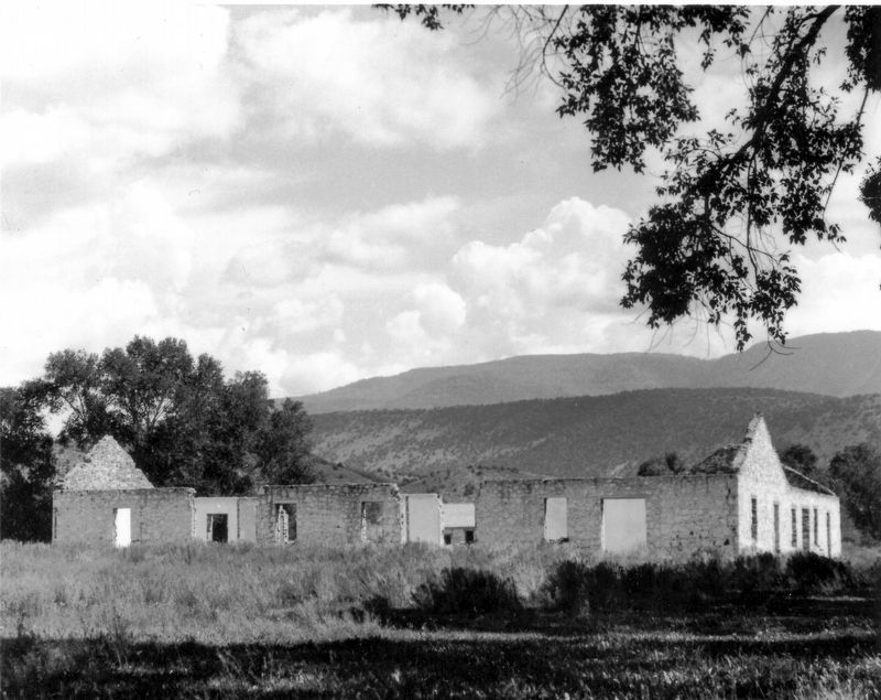
Completed April 12, 1867, by direction of Brigham Young, with L.D.S. Church funds, as a travelers way station and refuge from Indians. Ira N. Hinckley built and maintained it as a hostelry and residence until 1877. A well within the fort provided . . . — — Map (db m75519) HM
The first settlers in this area were the family of Charles W. and Eleanor Willden. They were English converts to the Church of Jesus Christ of Latter-day Saints who had come to Utah in 1849. Because Charles was an iron worker, Brigham Young called . . . — — Map (db m75518) HM
Soon after the first white families settled at Box Elder, they built a temporary fort to protect themselves from Shoshone Indian attacks.
The Davis Fort was named after their leader, William Davis and consisted of a row of simple log . . . — — Map (db m240496) HM
Settled March 31, 1851 by five families followed by six families in the fall. It was first called North Willow Creek and changed to Willard in 1857. The fort was built in 1853 to 1855, constructed of dirt and rock. The first grist mill was begun . . . — — Map (db m240488) HM
In July 1859 under the leadership of John Bair, (interpreter and guide) sixteen families settled here, built log cabins and dugouts between City Creek and Brower Springs. The following Spring other families arrived and a permanent fort was built for . . . — — Map (db m105497) HM
In March, 1864, about fifty pioneers under the leadership of Jens Nielson settled Panguitch. They built a fort of logs, enclosing their homes and a building used for church, school and recreation. The town was abandoned in 1867, because of Indian . . . — — Map (db m27020) HM
In April 1855, forty one men under the leadership of Alfred N. Billings were called to establish a mission in the Elk Mountains. They left Salt Lake City May 7, 1855, arrived at Grand River June 11, and selected the site for a settlement. By July . . . — — Map (db m95090) HM
In November 1851, thirty-five men from Parowan settled Cedar City. A unique temporary encampment, composed of their wagon boxes and sage brush walls, sheltered them through the first winter. In 1853, a fort 100 rods square was built on this site. . . . — — Map (db m59515) HM
In 1852 Peter Shirts located a ranch on Sidon Creek, later known as Shirts Creek. He offered John Hamilton half the water to come and settle there. Hamilton came with his family and Peter Fife. When Walker Indian War broke out they moved to Cedar . . . — — Map (db m59513) HM
During the summer of 1851, a small company of men was exploring this area and discovered the springs on the bench one-fourth mile to the east. Joel H. Johnson was so impressed with the spot, that he sought and received permission from George A. . . . — — Map (db m59571) HM
Old Kanarra, as it was called by early inhabitants, was founded in the spring of 1861 by settlers who moved from Fort Harmony. The town was situated on Kanarra Creek about one mile north and east of the present location. Later, a group from . . . — — Map (db m59472) HM
Paragonah was founded in 1852. Indian trouble caused abandonment a year later until 1855 when the pioneer fort was built. The site was selected and dedicated by President Brigham Young.
The fort was 105 feet square with walls 3 feet thick at the . . . — — Map (db m59617) HM
This site marks the southwest corner of the old Parowan adobe fort. It was constructed at the direction of LDS leader Brigham Young, to help secure the new pioneers as they developed the mother town of Southern Utah. Conceptualized in 1851, the . . . — — Map (db m240472) HM
The first settlers arrived here in 1851. A one room building was erected and used for Church and School in 1852. Candice Smith and George Spencer and wife were teachers. In 1855 a schoolhouse was erected inside the fort and early teachers were: . . . — — Map (db m75271) HM
Completed in November 1854 by the Pioneers of Salt Creek (Nephi) for protection against Indians. The inclosure was 3 blocks square, from 1st West to 2nd East and from 1st North to 2nd South Streets. Markers have been placed at the corners. The . . . — — Map (db m75272) HM
Six people perished by fire at Fort Kanab on the windy night of December 14, 1870. Lost to the flames were five children and a wife of Levi Stewart, Founder of Kanab.
May the countenance of the Lord shine upon you and give you peace. — — Map (db m95007) HM
On June 14, 1870 Levi Stewart, who had been called from Salt Lake County by President Brigham Young to head a group of pioneers in settling this area, brought a party with seven wagons from Pipe Springs, where they had camped temporarily, to Fort . . . — — Map (db m41252) HM
The great Mormon frontiersman and Indian missionary settled in Tooele Valley, Utah in 1850 and began peaceful negotiations with the Red Men. He was so successful that the officials of the Church of Jesus Christ of Latter-Day Saints sent him to . . . — — Map (db m41254) HM
Kanab gets its name from a anglicized form of the Piute word “willows”, which grew abundantly along the creek banks.
The Kanab Fort was begun in 1864 under the direction of Jacob Hamblin as a protection from Indians and as a base to . . . — — Map (db m94938) HM
Erected as a defense against Pahvant Indians in the Black Hawk War, completed in 18 days by 98 men. Wm. S. Hawley and Isaac W. Pierce, foremen; John W. Radford, Supt. Opening celebration July 25, 1865. The fort was 550 feet square, bastions at . . . — — Map (db m69542) HM
This marks the Southwest corner of the Fort, built in October and November 1851 as protection from Indians, by first 17 families under direction of Anson Call, Jesse W. Fox, surveyor. About 2 city blocks in size, the front wall 8 to 10 feet high was . . . — — Map (db m69583) HM
Erected 1855-56, was 150 feet long north and south by 75 feet wide. Facing each other and standing 30 feet apart were two rows of adobe houses. The gateways were in the north and south walls.
Richard Johnson and William Stevens, Sr. and families . . . — — Map (db m69575) HM
On the present site of Draper Historic Park, with some expansion to the north and south, stood Draperville Fort. Fort Street was named for this historic enclosure.
According to the Eleventh General Epistle of the Presidency of The Church of . . . — — Map (db m224741) HM
This monument marks the site of Fort Herriman built in 1855 by Thomas Butterfield, Henry Herriman, Samuel Egbert, Robert Petty, and John Stocking, as protection against the Indians.
The Fort was abandoned in 1858, under instructions from . . . — — Map (db m35032) HM
Early in 1849 the Pioneers of Union settled 1½ miles South-East of here, water, grass, wood and clay were abundant, Silas Richards first Bishop and school teacher arrived November 4, 1949. In 1853-54 Union Fort was built on ten acres donated by . . . — — Map (db m150037) HM
The first known residents of the Riverton area were the Yo No Indians, a poor tribe living along the Jordan River. Well-worn trails extended from Utah Lake where various tribes wintered, to Bear Lake where they rendezvoused during the summer. Much . . . — — Map (db m34682) HM
On this ten acre square during the years 1847-1849 stood the first fort, historic Mormon bastion, sometimes called the "Plymouth Rock of the West." Homes were erected of logs or adobe, side by side, with the rear walls forming a protective . . . — — Map (db m35280) HM
The oldest building on Fort Douglas, constructed in 1863 of wood and adobe. Originally built as Post Commander's Quarters it served as housing for Officer and Enlisted families until 1879. — — Map (db m223088) HM
Fort Douglas
has been designated a
National
Historic Landmark
This site possesses national significance
in commemorating the history of the
United States of America
1970
National Park Service
United States Department Of . . . — — Map (db m223091) HM
Founded Oct. 22, 1862 by Brevet Major General Patrick Edward Connor and U.S. Volunteers ordered to defend western mail routes. Quartered first in tents and dugouts. Soon stone buildings were erected, some of which are standing. Named Camp Douglas by . . . — — Map (db m223087) HM
Restored and renovated through the generosity of the
George S. and Dolores Dore Eccles Foundation
First constructed at Fort Douglas in 1875 using native red sandstone from the nearby quarry in Red Butte Canyon, this building originally . . . — — Map (db m225327) HM
Restored and renovated through the generosity of the
George S. and Dolores Dore Eccles Foundation
First constructed in 1825 as Fort Douglas Post Headquarters, this historic structure built of Red Butte sandstone was converted into an . . . — — Map (db m225323) HM
Restored through the generosity of the
Willard L. Eccles Charitable Foundation
with additional support from alumni and friends of the
University of Utah Honors College
First constructed as barracks for soldiers at Fort Douglas in . . . — — Map (db m225328) HM
Mining and Fort Douglas have been linked historically since 1863. Colonel Patrick E. Connor was the first commanding officer of the post newly established by President Abraham Lincoln to maintain contact between the East and West during the Civil . . . — — Map (db m225325) HM
Restored through the generosity of Kay Winston and Allan M. Lipman Jr. and Nancy Lipman and Clark P. Giles
The Post Bandstand has stood as the centerpiece of Fort Douglas for over 125 years. Soldiers, families, and Salt Lake City's citizens met . . . — — Map (db m223090) HM
Upon the advice of Brigham Young, the first settlers west of the Jordan River built English Fort in 1853 for protection from Indians. Thick walls of rock and adobe with one gate surrounded the two acres of land. Adobe partitions separated the . . . — — Map (db m137520) HM
A blacksmith shop with a skilled blacksmith was a necessity. Amasa Barton (Joseph Barton's brother) was kept busy fitting horseshoes, repairing wagons and making , sharpening and repairing everything from farming implement to carpentry tools.
In . . . — — Map (db m95040) HM
The Jones log cabin was located in the northwest corner of the fort. Near the turn of the century, the Joneses constructed an elegant stone home adjacent to their original cabin. Fire destroyed the Jones home in 1975.
In 1896, a gold rush brought . . . — — Map (db m95038) HM
In 1879, at age 17, Parley R. Butt was one of 26 men who scouted possible routes for the San Juan Mission and established Montezuma Fort. A few months later, he traveled with the main group of pioneers as they blazed the Hole-in-the-Rock road. In . . . — — Map (db m95041) HM
Upon the pioneers' arrival in the Bluff valley, water for cooking and drinking was carried from the San Juan River. According to Mary Mackelprang Jones, water from the San Juan “O was so hard and muddy cottonwood ashes were put in it to stand . . . — — Map (db m95039) HM
The community's co-op store was located in the northeast corner of the fort. This cooperative venture, which provided a means for buying, selling and trading, became very successful. The Navajos and Utes also frequented the store, trading their . . . — — Map (db m95036) HM
There were two forts on this site in 1854-55. The settlers referred to the first structure as Little Fort. Mormon pioneers sent men from other Central Utah settlements on February 7, 1854 to start work on the small fort that would cover about . . . — — Map (db m75025) HM
Near this spot February 7, 1854, twenty-five men organized in military order, began the construction of a small fort for protection from the Indians. The walls, made of rock were seven feet high, almost two feet thick, and formed the outer wall of . . . — — Map (db m74998) HM
Gunnison was settled in 1859. As a precinct it was granted weekly U.S. Mail service in 1862. The Black Hawk War began in 1865. In 1867 a bastion was erected 362 feet southeast of here. It was used by Colonel Byron Pace and 1500 militia men to . . . — — Map (db m74907) HM
Third fort built in Manti
Location: 9 blocks in center of city
Marker Location
Construction: Rock, adobe, and
mud-filled wood frame
Walls: 12' high, 3' wide at base,
2' wide at top
Protection of settlers livestock
From Indian . . . — — Map (db m74944) HM
*Marker Location
Little Stone Fort Erected 1852 By Mormon Pioneers
First Fort Built in Manti
Location: NW quarter Block 64
Foundation: 3' wide, stone
Walls: 12' high, 2' thick
Provided protection from Hostile Ute . . . — — Map (db m243321) HM
Erected in 1865 on order of General D.H. Wells to protect the settlers during the Black Hawk War. The fort covered the present City Hall Block and westward with 12 ft. rock walls supporting cabins along the inside. The bastion stood on the Lincoln . . . — — Map (db m75190) HM
Mt. Pleasant, a small town nestled at the foot of the mountains in Sanpete County near the geographic center of Utah, was settled early in 1859. During June the men kept busy tending their crops and building a fort, twenty-six rods by twenty-six . . . — — Map (db m75169) HM
Pioneers and Families who lived in
Fort Alma (later Monroe) 1864-1867
Major Allred, Parley Allred, Wiley Allred, Andrew Anderson, Israel Bale, Benjamin Barney, Walter Barney, Joseph Besswick, George Blacket, John W. Bohman, Thomas Broadbent, . . . — — Map (db m74806) HM
Near this spot in 1865 a rock fort was built as a protection from Indians. It was a cooperative project. Each man who owned a city lot built one rod of the wall which was 3 l/2 feet at base, 12 feet high, 1 foot at top. There were portholes at . . . — — Map (db m74820) HM
Work on the Fort began in 1865. The Fort was 214 feet square, on ground purchased from Christian Sorenson. The walls were 10 feet high, and 2 feet thick, with bastions 10 feet square at the four corners, with port holes in walls and bastions. Inside . . . — — Map (db m74859) HM
This monument is near the site of the old fort, 300 ft. so. west of here. It was on old Emigrant Trail. Route also used by Overland Stage and part of Johnston's Army going east in 1861, to participate in the Civil War. The fort was built during the . . . — — Map (db m67624) HM
detachment of the U.S. Army, the first to enter the Rocky Mountain region, consisting of two companies of artillery, 85 dragoons, 130 teamsters, herders and hostlers from Fort Leavenworth, Kansas, under the command of Col. E.J. Steptoe, reach . . . — — Map (db m149985) HM
Jeremiah Hatch came to Ashley Valley in 1878 as an Indian agent. Following the Meeker, Colorado massacre of 1879 he was instructed to build a fort as protection for white settlers. Their cabins, with cedar post buttresses between, formed part of . . . — — Map (db m114422) HM
Eight rods W. of this marker was the S.W. corner of a fort erected for protection from the Indians in the Walker War. The walls enclosed three separate squares: in 1853, an 8 ft. mud wall built around a 33 r. sq. was named Fort Wordsworth; in 1854, . . . — — Map (db m224159) HM
Dedicated to the Two Hundredth Anniversary of the United States of America and sponsored by the
Utah American Revolution Bicentennial Commission
and Alpine Bicentennial Committee
John Rowe Moyle, emigrating from England in 1856 as . . . — — Map (db m224303) HM
Gifted to Alpine City at their request, for a park, by the children of Joseph Edward and Matilda C. Hanson Moyle. Joseph, youngest son of John Rowe and Phillipa Beer Moyle, was a life long resident and late owner of the property.
Dedicated to . . . — — Map (db m224310) HM
The Moyle House and Indian Tower are significant examples of vernacular architecture from Alpine’s early settlement period. The Indian Tower is unique as the only structure of its type known to have been built to protect a single homestead in Utah. . . . — — Map (db m224165) HM
In 1852 Mormon Pioneers who had settled on the American Fork creek received orders to build a fort for protection from Indians. Most cabins were moved into an enclosure 80x74 rods, covering 37 acres. By 1855 each of the families built a wall 12x6 . . . — — Map (db m149844) HM
Upper Marker:
Fairfield - Camp Floyd - Fort Crittenden
In 1855 Fairfield was settled by John Carson, William Carson, David Carson, William Beardshall and John Clegg. A rock fort 4 rods square was erected in 1856-57, this monument . . . — — Map (db m149983) HM
The fort was 60 rods square with corners built of logs forming a buttress. Adobe, rock and mud walls
stood 8 feet tall, 4' wide at the bottom and 2' at the top. On a rock foundation with a deep 4' trench
around the outside. It was built during . . . — — Map (db m148786) HM
The fort was 60 rods square with corners built of logs forming a buttress. Adobe, rock and mud walls
stood 8 feet tall, 4' wide at the bottom and 2' at the top. On a rock foundation with a deep 4' trench
around the outside. It was built during . . . — — Map (db m148787) HM
The fort was 60 rods square with corners built of logs forming a buttress. Adobe, rock and mud walls
stood 8 feet tall, 4' wide at the bottom and 2' at the top. On a rock foundation with a deep 4' trench
around the outside. It was built during . . . — — Map (db m148789) HM
The fort was 60 rods square with corners built of logs forming a buttress. Adobe, rock and mud walls
stood 8 feet tall, 4' wide at the bottom and 2' at the top. On a rock foundation with a deep 4' trench
around the outside. It was built during . . . — — Map (db m148790) HM
In 1853 because of Indian troubles, Brigham Young instructed the people to build forts for protection. A two foot six inch rock wall from three to five feet high, four city blocks square, was built here.
Private homes faced the center of the . . . — — Map (db m149513) HM
The original settlement at Provo (Fort Utah) was established March 12, 1849 by President John S. Higbee, with Isaac Higbee and Dimick B. Huntington, counselors, and about 30 families or 150 persons, sent from Salt Lake City by President Brigham . . . — — Map (db m149025) HM
Provo was settled by Mormon pioneers March 12, 1849. East of this monument a second fort was built in April, 1850. It was here that the settlers were threatened with massacre by Chief Walker and his Band of Indians, but were saved by Chief Sowiett's . . . — — Map (db m149444) HM
In February, 1850, militiamen from Fort Utah and Salt Lake City defeated the Timpanogots band of Utes in a pitched battle on the banks of the Provo River near what is now Riverside Plaza.
The Indians who survived escaped from the valley. . . . — — Map (db m223686) HM
A group of about 30 adult men – a few with their families and others with teenage sons – left Salt Lake City on Saturday, March 31, 1849, arriving the next day at the Provo River near what is now Geneva Road and 200 North.
Under the direction . . . — — Map (db m223736) HM
Provo constructed its first tabernacle on the northeast quarter of the block fronting on Center Street and University Avenue. Selecting its site caused a fair amount of controversy.
When Brigham Young visited Utah Valley for the first time in . . . — — Map (db m223733) HM
This monument marks the site of Pond Town Fort. In 1851 David Fairbanks and David Crockett located land adjacent to a small stream at the head of Salem Lake and built a dam. In 1856 Eli Ashcraft, Royal Durfrey, Silas Hillman, Aquilla Hopper, Jacob . . . — — Map (db m101962) HM
Settled by Mormon pioneers in 1851 a branch of the Church of Jesus Christ of Latter-day Saints was organized on December 21, 1851 with William Pace as bishop. — — Map (db m98354) HM
In 1862 a fort was erected one mile and a quarter north from this spot, on the west bank of the Spanish Fork River. It was a square and covered one acre of ground. The walls were four feet thick at the base and tapered to about two and a half feet . . . — — Map (db m148721) HM
Spanish Fork had its beginning in two sites, the upper settlement in 1850-51, located in the southeast river bottoms, the other at Palmyra, 1851. Fearful of Indian trouble, settlers built an adobe fort between the two places in 1854, located two . . . — — Map (db m148740) HM
This monument marks the south-west corner of Fort Palmyra. This fort was built by the settlers for protection. Palmyra was selected in 1852 as a suitable place to build a city by Apostle Geo. A. Smith. The first home was built in August of that . . . — — Map (db m148723) HM
This monument stands 62 feet South, 2 feet East of the center of the fort built in 1862 by William M. Wall and the pioneers of Wallsburg. 20 families lived in the fort which was 400 feet square. This valley, known to the Indians as Little Warm . . . — — Map (db m149978) HM
With the settlement of Toquerville in 1858 by the first six families and others soon to join them, they soon realized that the pressures on the available irrigated farmland could not support the increasing population. Survival would depend on . . . — — Map (db m59446) HM
Established May 9, 1854, by John D. Lee, Richard Woolsey, William R. Davis and others who had founded Harmony in 1852. County seat of Washington County until 1859. Headquarters of Mormon Mission to Lamanites 1853-1854.
The fort was finally . . . — — Map (db m59470) HM
In 1852 Elisha H. Groves, John D. Lee and others built a fort on Ash Creek, called Harmony. The fort was abandoned in 1854 and a new site located called Fort Harmony. Following disastrous floods in 1862 settlers again moved and established . . . — — Map (db m59471) HM
November 28, 1861 about 93 pioneers under the leadership of Daniel Bonelli, were sent by President Brigham Young to settle southern Utah and raise cotton and grapes. They located at the fort built by Jacob Hamblin and others along Santa Clara Creek, . . . — — Map (db m59019) HM
Miles Goodyear, born in Connecticut in 1817, migrated at age 19 to the west during the era of the fur traders. In 1845 he established Fort Buenaventura (Good Adventure) near the confluence of the Weber and Ogden Rivers. His stockade included a few . . . — — Map (db m171266) HM
In 1854 Ogden pioneers built a rock and mud wall a mile square along 28th Street, Wall Avenue and 21st Street. Madison Avenue was not completed because the Indians became peaceful. The eight foot wall had a six foot base, a 31 inch top and four . . . — — Map (db m81035) HM