During the last years of Reconstruction, Maj. William Royall established the Royall Undertaking Company to serve African Americans denied mortuary services by Savannah's White-owned funeral homes. As a formal mortuary education was not available in . . . — — Map (db m200259) HM
World-renowned songwriter John Herndon Mercer was born in Savannah and spent much of his youth in this house at 226 East Gwinnett Street. His lyrics reflected the sounds of Southern conversation, influenced by the African-American music and the . . . — — Map (db m8702) HM
Louis Burke Toomer, African-American leader, local bank founder, and realtor, was born in Savannah in 1897. Raised and educated locally, Toomer established the Georgia Savings and Realty Corporation on February 23, 1927, in the historic black . . . — — Map (db m127134) HM
The first schools in the West Savannah neighborhood were established on Fell Street south of this spot in the early twentieth century. The Saint Anthony of Padua school was one of three schools established by Father Ignatius F. Lissner and a group . . . — — Map (db m157196) HM
The Hudson Hill community derives its name from the first pastor of the Friendship Baptist Church located on Weldon Street. The church, established on April 10, 1895, was served by Rev. A. Hudson for its first 13 years. Rev. Hudson was such an . . . — — Map (db m157283) HM
The McKelvey-Powell Building was originally constructed in 1926. The building was a hub of African-American business and social life in Savannah during the era of segregation in the first half of the twentieth century. Throughout the 1930s the . . . — — Map (db m11751) HM
Mathilda Taylor was born in 1834 in New Orleans, and came to Savannah as a young woman. She taught black children in her home before the Civil War, when it was still illegal. She married Abraham Beasley, a successful black businessman, in 1869. . . . — — Map (db m6009) HM
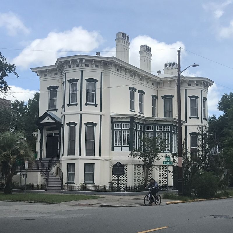
This was the site of the first hospital in Savannah to train African-American doctors and nurses. Named for Doctors Cornelius and Alice McKane, it began on June 1, 1896, when a small group of African Americans received a charter to operate the . . . — — Map (db m11703) HM
In 1906, eleven African-American men formed the Colored Library Association of Savannah and established the Library for Colored Citizens. They acquired the original collection from personal libraries and public donations of books and periodicals. In . . . — — Map (db m108955) HM
Florance Street School was designed by the firm Levy and Clarke and built in 1929 as one of the early public schools in Savannah built specifically for African-American students. It contributed greatly to Savannah’s Cuyler-Brownville community by . . . — — Map (db m12088) HM
In 1853, the city reserved 4 acres in the new Laurel Grove Cemetery for Savannah’s African American community. This new burial ground replaced an older black cemetery located near Whitefield Square. Pastors Andrew Bryan (First Colored Baptist . . . — — Map (db m8498) HM
The first African Methodist Church in Georgia was organized by the Rev. A. L. Stanford on June 16, 1865, at Savannah, Georgia and was given the name Saint Phillip African Methodist Episcopal Church.
Two months and fifteen days later, the Sunday . . . — — Map (db m9392) HM
Savannah High School evolved as the senior division of Chatham Academy, chartered by the Georgia Legislature in 1788. In 1935, due to overcrowding in schools, the Board of Education collaborated with the Public Works Administration to erect this . . . — — Map (db m9291) HM
Chartered by the Georgia General Assembly in 1832, the Infirmary was established "for the relief and protection of afflicted and aged Africans" under the provisions of the last will and testament of Savannah merchant and minister Thomas F. Williams . . . — — Map (db m6407) HM
On November 28, 1959, the residence of Dr. Calvin and Virginia Kiah at 505 W. 36th Street opened to the public as the Kiah Museum. The Kiah's were pioneers in the black cultural and museum movement and created the first African American-founded . . . — — Map (db m200260) HM
This is one of four sites historically used by African-Americans in the community to access the water. The community thrived on maritime activities such as fishing, shrimping, oystering and crabbing. These resources were not only used to feed . . . — — Map (db m200263) HM
This is one of four sites historically used by African-Americans in the community to access the water. The White Bluff/Coffee Bluff area is unique in that, primarily because of its relative isolation, the community has been able to preserve many of . . . — — Map (db m200265) HM
African-American physician Cornelius McKane (1862-1912) was born in British Guiana and began medical practice in Savannah in 1892. Alice Woodby McKane (1865-1948) came to Georgia that same year – the only black female physician in the state at . . . — — Map (db m11727) HM
This is one of four sites historically used by African-Americans in the community to access the water. The White Bluff/Coffee Bluff area is in close proximity to St. Catherines Island, Ossabaw Island, and Sapelo Island, in addition to the Vernon and . . . — — Map (db m200266) HM
Urbanization of western Savannah in the early twentieth century was spurred by growth in employment opportunities at the Central of Georgia Railroad facilities, the port, and the port-dependent industries that included the Hilton-Dodge Lumber . . . — — Map (db m156959) HM
One of the largest sales of enslaved persons in U.S. history took place on March 2-3, 1859, at the Ten Broeck Race Course ¼ mile southwest of here. To satisfy his creditors, Pierce M. Butler sold 436 men, women, and children from his Butler Island . . . — — Map (db m15838) HM
Moses J. Jackson was the founder of the first public elementary school for African American students in West Savannah. He was a highly admired and respected community leader who championed many significant initiatives in the decades before and after . . . — — Map (db m157280) HM
From 1878 to 1889, Robert Sengstacke Abbott lived in the parsonage of Pilgrim Congregational Church, once located on this site. His stepfather John H. H. Sengstacke, minister of the church, published the Woodville Times. Abbott learned the . . . — — Map (db m15782) HM
Andrew Bryan was born at Goose Creek, S.C. about 1716. He came to Savannah as a slave and here he was baptized by the Negro missionary, the Reverend George Leile, in 1781. Leile evacuated with the British in 1782 at the close of the American . . . — — Map (db m15624) HM
Over this ground, hallowed by the valor and the sacrifice of the soldiery of America and of France, was fought October 9, 1779, one of the bloodiest battles of the Revolution when Savannah, which the British had possessed for several months, was . . . — — Map (db m243780) HM
The railroad provided separate washroom facilities for whites and African-Americans.
Facilities and opportunities were quite different for black and white people historically in the segregated South. Jim Crow laws required “separate but equal” . . . — — Map (db m70293) HM
First Bryan dates its founding to the constitution of the Ethiopian Church of Jesus Christ under Rev. Andrew Bryan in January 1788, making it one of the nation's oldest African-American Baptist churches. Known later as First Colored Church, First . . . — — Map (db m200204) HM
Union forces took back Fort Pulaski in 1862, opening a door to freedom for enslaved people in the region. Families fled to this Union outpost in Confederate territory for liberty and protection. The military recruited African American men from the . . . — — Map (db m134093) HM
On April 13, 1862, following the Union capture of Ft. Pulaski during the Civil War, Maj. Gen. David Hunter issued General Orders No. 7 freeing those enslaved at the fort and on Cockspur Island. Hunter, an abolitionist advocating the enlistment of . . . — — Map (db m13830) HM
In 2019, Tybee Island was designated a UNESCO Site of Memory as a documented trans-Atlantic location where kidnapped African men, women, and children who survived the Middle Passage arrived. Fifty-three ports line the coast of the continental . . . — — Map (db m210670) HM
The Middle Passage is a scar on the history of humanity. It is not a single race, religion or country's responsibility to bear; it belongs to the world. The enslavement of Africans was a global system that lasted more than 300 years. The Middle . . . — — Map (db m210667) HM
Launched in 1994. the international and inter-regional project The Routes of Enslaved Peoples: Resistance, Liberty, Heritage addresses the history of the slave trade and slavery through the prism of intercultural dialogue, a culture of peace and . . . — — Map (db m210668) HM
In the early 1960s, Savannah Beach, now Tybee Island, GA, was the site of Civil Rights protests called wade-ins, akin to the sit-in demonstrations of the time.
These protests, planned and conducted by the NAACP Savannah Youth Council, sought to . . . — — Map (db m200228) HM
This memorial is dedicated to
the remarkable life of
Melvinia “Mattie” Shields McGruder.
She was born a slave in
South Carolina in 1844.
At age 6 she was brought to
the nearby Shields farm
in what is now
Rex, Clayton County, . . . — — Map (db m227406) HM
The Mable Family Cemetery is the final resting place for both the Mable Family and some of their slaves. The family section which contains twenty-three graves is paved and covered with pea gravel. Twenty-two of the graves are marked.
The first . . . — — Map (db m197615) HM
In the 1800s, a house fire would have been catastrophic, so food was prepared in this kitchen house and carried to the main house. Food was cooked in cast iron pots and pans in the fireplace and later, on a cast iron wood-burning stove. The two . . . — — Map (db m197622) HM
In grateful
acknowledgement to God for
those African-Americans
here, known and unknown,
who, in slavery, lived,
served, and enrichened the
history of Mableton
From Robert Mable's family Bible
*Gelia Born December 31st 1824 • . . . — — Map (db m197614) HM
In 1860, forty-five percent of the population of Marietta was enslaved.
There were four enslaved persons at the Root property – two men and two
women, ranging in age from 35 to 73. There was a separate dwelling for these
individuals noted in the . . . — — Map (db m227640) HM
In respectful memory of the thousands
across America, denied justice by lynching;
victims of hatred, prejudice, and ignorance.
Between 1880-1946,
~570 Georgians were lynched. — — Map (db m136757) HM
The Lemon Street Grammar School opened in 1894. The original wooden structure was funded by Marietta’s school board, and designed to educate Negro students. The high school was built nearby in 1930 at urging of Ursula Jenkins. Professor M. J. Woods . . . — — Map (db m60575) HM
Zion Baptist Church was organized in 1866 by 88 former slaves who left First Baptist Church. The first worship place was a brush arbor. Next a small wooden structure was built which was destroyed by fire.
In 1888, the present structure was . . . — — Map (db m42785) HM
Prominent minister who was born a slave 1833. He was a charter member of Zion Baptist at its founding in 1866 and its second pastor (1869-1885). In 1885 he organized Cole St. & later Pleasant Grove and Whitlock Avenue Baptist Churches. In 1890 . . . — — Map (db m15191) HM
The only slave burial ground in any major white Georgia cemetery. Here 19 Christian slaves and freed persons of Marietta Christians were buried in unmarked graves ca. 1848-1866. Only four have been positively named, servants of Mrs. Eliza G. . . . — — Map (db m15188) HM
On June 27, 1864, Austin Gilmore of Tennessee fell, mortally wounded, in ferocious fighting near this wide field. But Gilmore held no military rank and no rifle. He held only a stretcher bearing a wounded soldier. An American of African descent, . . . — — Map (db m243772) HM
James William Cureton was born on December 25, 1829 in North Carolina. As a young man he went to Tennessee where he married Nancy Boyd. In 1849, he moved to Dade County in Georgia with the intention of finding a good site for a water powered mill. . . . — — Map (db m167659) HM
"Cloverdale" was a successful plantation established by Colonel James Cooper Nisbet and his brother. At the start of the war, James Nisbet raised a company for the 21st Georgia Infantry Regiment and went to Virginia as a Captain. In the spring of . . . — — Map (db m167667) HM
William I. Cole was a prosperous 51 year old farmer at the time of the 1860 Federal census, living with his wife and three children. With a plantation on Squirrel Town Creek, he was one of the best known slave owners in Dade County. In addition to . . . — — Map (db m167716) HM
William Isham Cole was born May 7, 1805. He married Lovina Clark about the same time as the Treaty of New Echota between the U.S. Government and the Cherokee Nation that ended all Native land claims in the State of Georgia. Cole took advantage of . . . — — Map (db m134461) HM
First Flint River Baptist Normal Institute
In 1876, the First Flint River Missionary Baptist Association was formed to help “lift the veil of ignorance from its people” using land purchased in 1896 and 1915. The Association . . . — — Map (db m40946) HM
The first school for former slaves in this county was established in 1869 and was known as the Whittier School and Tabernacle for Colored Children. It was on Shotwell Street and had grades 1-7. The name soon changed to Whittier Normal School . . . — — Map (db m40945) HM
On November 15, 1864, during the Civil War, U.S. forces under Gen. William T. Sherman set out from Atlanta on the March to the Sea, a military campaign designed to destroy the Confederacy's ability to wage war and break the will of its people to . . . — — Map (db m102926) HM
Lynching in America
Racial terror lynching claimed the lives of thousands of African
Americans between 1877 and 1950. Following the Civil War, white
Southerners sought to uphold an ideology of white supremacy and
used fatal violence . . . — — Map (db m185921) HM
Lynching in America
Following the Civil War, violent resistance to rights for African Americans, a need for heap labor, and an ideology of white supremacy led to fatal violence against Black women, men, and children. Thousands of Black . . . — — Map (db m245402) HM
The Beacon Community was the center of Decatur’s African American community until its demolition by the Urban Renewal programs of the mid-1960s. Bounded by N. McDonough Street on the east, W. Trinity Place on the north, Water Street on the west and . . . — — Map (db m29260) HM
Dr. Martin Luther King, Jr. was sentenced here, at the site of the former DeKalb
Building, on October 25, 1960, to four months of hard labor for protesting segregation
with the Atlanta Student Movement at a Rich's Department Store dining room. . . . — — Map (db m173323) HM
Lynching in America
Following the Civil War, violent resistance to rights for African
Americans, a need for cheap labor, and an ideology of white supremacy
led to fatal violence against Black women, men, and children.
Thousands of Black . . . — — Map (db m242055) HM
Established in 1959, Vienna High and Industrial School was a consolidated school for African Americans during segregation. As part of Georgia's massive resistance to federally mandated school integration, politicians and school officials sought to . . . — — Map (db m127159) HM
Governor George Busbee (1927-2004) and his family lived in this ranch style home (c.1956) from 1962 until 1983. Busbee launched his underdog campaign from this residence in 1974 to become Georgia’s 77th governor with the slogan, “Elect a . . . — — Map (db m117147) HM
C.B. King dreamed of becoming a lawyer. He had served in the United States Navy and graduated from Fisk University. Because there was no law school for Blacks in segregated Georgia, he earned a law degree from Case Western Reserve University Law . . . — — Map (db m117200) HM
DedicationOn July 7, 1994, the waters of the Flint River breached the levee that protected the campus of Albany State University. By the time the river crested, the water had risen to a maximum depth of 14 feet and had damaged all of the . . . — — Map (db m186991) HM
During the Albany Movement (1961-1963), as part of the Civil Rights Movement, the area here bordering the former Albany City Hall and jail became known as Freedom Alley. Located at what is now the Central Square Government Complex, the location . . . — — Map (db m117127) HM
The Albany Movement began here, at Shiloh Baptist Church, in November 1961. A coalition of black improvement associations and student activists from SNCC and Albany State College, the protest group set an unprecedented goal: the desegregation of an . . . — — Map (db m117148) HM
The Pilgrim Missionary Baptist Normal and Industrial Institute for Colored Students was established here in 1880 by the Pilgrim Missionary Baptist Association. The school was established, organized, funded and staffed by African Americans. The . . . — — Map (db m7965) HM
This cemetery has been the primary burial site for the town of New Ebenezer and the congregation of Jerusalem Lutheran Church since at least the mid-1740’s. An earlier burial ground dating from 1734 was located at the site of Old Ebenezer near . . . — — Map (db m156763) HM
Georgia Governor Herman Talmadge created the Minimum Foundation Program in 1949 as part of a statewide equalization effort to improve school buildings and yet maintain racial segregation. Completed in 1956, Springfield Central High School . . . — — Map (db m238216) HM
Rev. Daniel Tucker owned a large plantation on the Savannah River and is buried near his old homesite, “Point Lookout,” six miles from here. Born in Virginia, February 14, 1744, Daniel Tucker came here to take up a land grant. A . . . — — Map (db m38575) HM
Today’s Flat Rock AME Church originated in 1854 as a place of worship for slaves on nearby Spears Plantation, and it is believed to be the oldest African-American congregation in Fayette County. Originally known as Rocky Mount, the church moved . . . — — Map (db m22973) HM
Hugh Manson Dorsey was born in Fayetteville, and was admitted to the Georgia bar at the Fayette County Courthouse in 1894. After practicing law at his father’s firm, Dorsey became solicitor general of the Atlanta Judicial Circuit in 1910. In this . . . — — Map (db m10074) HM
This church was organized in 1897 near the banks of Camp Creek in an unincorporated area of western Fayette County. Until the first sanctuary was constructed here on land and with building materials donated by Flem Arnall, services were held under a . . . — — Map (db m22971) HM
Lynching in America
Thousands of Black people were the victims of racial terror lynchings
in the United States between 1877 and 1950. After the Civil War,
violent resistance to the equal rights for African Americans and an
ideology of . . . — — Map (db m171844) HM
Social activist Lugenia Burns Hope was born in St. Louis, Missouri. Following her father’s death, her family moved to Chicago, Illinois, where she became involved in social work. In 1897, she married Dr. John Hope and the couple moved to Atlanta, . . . — — Map (db m235239) HM
The National Medical Association (NMA) was founded in 1895 when African-American physicians met at Atlanta's Cotton States and International Exposition. Formally established here at First Congregational Church, the NMA served as a professional . . . — — Map (db m238138) HM
In the spring of 1960, students from Atlanta University, the Interdenominational Theological Center, Clark, Morehouse, Morris Brown, and Spelman colleges formed the Atlanta Student Movement and joined thousands of other students throughout the South . . . — — Map (db m234845) HM
In March of 1960, students of the six colleges comprising the Atlanta
University Center, having decided to challenge the scourge of
segregation in public and private facilities of Atlanta, presented a
manifesto entitled “An Appeal for Human . . . — — Map (db m185984) HM
In February 1960, here at the site of Yates and Milton Drugstore, three students
from Morehouse College - Lonnie King, Joseph Pierce, and Julian Bond-- began to
rally students from Atlanta's other historically black institutions-- . . . — — Map (db m185906) HM
On this site stood Yates and Milton Drug Store, the first African American Business of its kind in Atlanta.
It was here that the Atlanta Student Movement
was planned on February 4, 1960.
Clark College Class of 1961
Dedicated during . . . — — Map (db m185924) HM
In early February 1960, Morehouse College students Lonnie King,
Julian Bond, Joseph Pierce and other students met here at the site
of the former Yates & Milton Drug Store-an informal gathering place
for students of the Atlanta University Center. . . . — — Map (db m185926) HM
The Georgia School of Technology held its first classes
in the fall of 1888 in two towering buildings. One of them,
now known as Tech Tower, housed classes taught by
five professors. The other was a machine shop, fully
stocked with a foundry, . . . — — Map (db m227626) HM
The Atlanta Ladies Memorial Association (ALMA) formed in 1866 with a purpose to “preserve and foster the memory of our Confederate Dead.” The federal government did not fund Confederate burials after the war. Volunteer groups, often organized by . . . — — Map (db m186549) HM
In 1850 the City of Atlanta established a public cemetery on this ridge overlooking downtown. Originally known as Atlanta or City Cemetery, the name Oakland was adopted in 1872 because of its many oaks. It was the principal burial ground for Atlanta . . . — — Map (db m10148) HM
In 1852 the Atlanta City Council ruled that African Americans were to be buried in a segregated section at the rear of Oakland Cemetery, at the eastern boundary of the original 6 acres. By the beginning of the Civil war, more than 800 persons . . . — — Map (db m64824) HM
In 1866, the city of Atlanta set aside this 3.2-acre section of land for African Americans to buy burial plots. Before 1866, African Americans were buried in an area called Slave Square in Oakland Cemetery's original six acres. The practice of . . . — — Map (db m186550) HM
Oakland's African American Burial Grounds reflect the extent of racial segregation in America. From 1866 until 1963, African Americans could only buy burial plots in this section. As people were racially segregated in daily life — in education, . . . — — Map (db m186558) HM
Constructed in 1908, the Women's Comfort Station served as a bathroom and place of shelter during extreme weather. The Men's Comfort Station, located next to the African American Burial Grounds and Potter's Field, was completed the same year. . . . — — Map (db m186565) HM
Alonzo Herndon was born into slavery in Walton County, Georgia, in 1858. After moving to segregated Atlanta, Herndon opened several barbershops including the upscale Crystal Palace in 1902. In 1905, he purchased a small mutual aid association that . . . — — Map (db m185910) HM
By 1920, Auburn Avenue had become the "Main Street" of
Black Atlanta. Many prominent African Americans lived along or near this prosperous commercial avenue, where the city's leading Black enterprises and institutions could be found: real . . . — — Map (db m186002) HM
Pause and look up at this massive overpass: an entire block of Black-owned businesses were demolished to construct it. Buildings and businesses lost included Simmons Shoe Repair, Jordan Photography Studio, Star Cab Stand, Henray's Five and Dime, and . . . — — Map (db m186441) HM
Big Bethel served as Sweet Auburn's City Hall, the site of mass meetings to improve the lives of Atlanta's blacks in the first half of the 20th century. The church established the Gate City Colored School, the first public school for black students . . . — — Map (db m186416) HM
The churches of Auburn Avenue — especially Big Bethel A.M.E., Wheat Street Baptist and Ebenezer Baptist — have played a dual role: they are places of worship, and they are centers of political, economic and social activity.
Founded during the . . . — — Map (db m186415) HM
This site was the original location of Bronner Brothers Hair Care Products. Nathaniel Bronner, the only male in the 1939 graduating class of the Apex Beauty College, established his hair care products business here in the 1950s.
Constructed in . . . — — Map (db m186414) HM
This building was constructed in 1915 and originally used as a lodge. W.H. Hanley, a native of Winchester, Tennessee, gained experience in the funeral home business as an employee of David T. Howard Funeral Home, Atlanta's first Black owned funeral . . . — — Map (db m186420) HM
John Smith, a white
businessman, who employed many African Americans, established a carriage factory here in 1869 adjacent to his home. Alonzo Herndon, a slave-born barber who founded the Atlanta Mutual Insurance Association in 1905, renovated . . . — — Map (db m185994) HM
As early as 1867, Atlantans began campaigning for African American police officers. Finally, in 1948, eight Black policemen were sworn into service. Barred from the Decatur Street police station because of their race, the men used the Butler Street . . . — — Map (db m186417) HM
John Calhoun Park commemorates one of Auburn Avenue's leading businessmen. Calhoun was a realtor, a local NAACP leader during the 1940s and 1950s, and a Republican Party activist who served on the Atlanta City Council during the 1970s.
Businesses . . . — — Map (db m186442) HM
John Calhoun Park commemorates one of Auburn Avenue's leading businessmen. Calhoun was a realtor, a local NAACP leader during the 1940s and 1950s, and a Republican Party activist who served on the Atlanta City Council during the 1970s. Businesses . . . — — Map (db m186443) HM
Constructed in 1912, the Odd Fellows Building was one of Auburn's most innovative projects. The office complex was the brainchild of Benjamin J. Davis, leader of the Grand United Order of Odd Fellows fraternal organization. Davis led a campaign to . . . — — Map (db m186418) HM
I call it my Auburn Avenue, the street which is known all over America as the center of activity among black people in the south.
I.P. Reynolds, letter carrier and writer
Here, in the days before desegregation, blacks . . . — — Map (db m185991) HM
South-View Cemetery was founded in 1886 by formerly enslaved African Americans who objected to the conditions and the treatment they received at Atlanta's segregated burial grounds. South-View's landscape reflects the influence of 19th century . . . — — Map (db m186568) HM
Former slave, Principal of Tuskegee Institute and author of Up From Slavery, Washington delivered the Atlanta Exposition Address on September 18, 1895 at this site, the former auditorium of the Cotton States and International Exposition. . . . — — Map (db m73369) HM
520 entries matched your criteria. Entries 101 through 200 are listed above. ⊲ Previous 100 — Next 100 ⊳