After filtering for New Jersey, 287 entries match your criteria. Entries 101 through 200 are listed.⊲ Previous 100 — The final 87 ⊳
Architecture Topic
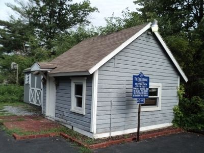
By Bill Coughlin, July 24, 2011
The Medford Toll House
| 101 ► New Jersey, Burlington County, Medford — 28 — The Toll House — 1847 - 1997 — |
| On Medford/Mt Holly Road (County Route 541) north of Church Road, on the right when traveling south. | |||
| 102 ► New Jersey, Burlington County, Medford — 26 — The William Dyer House — 1847 - 1997 — |
| On S Main Street (County Route 541) south of South Street, on the right when traveling north. | |||
| 103 ► New Jersey, Burlington County, Mount Holly — Historic Burlington County Prison Museum — 1811-1865 — |
| On High Street at Grant Street, on the right when traveling south on High Street. | |||
| 104 ► New Jersey, Burlington County, Mount Holly — Historic Prison — |
| On High Street at Grant Street, on the right when traveling south on High Street. | |||
| 105 ► New Jersey, Burlington County, Mount Holly — Shinn-Curtis Log House — |
| On Park Drive at Commerce Street, on the left when traveling south on Park Drive. | |||
| 106 ► New Jersey, Burlington County, Palmyra — Spring Garden Street School — |
| On East Spring Garden Street east of Cinnaminson Avenue, on the right when traveling east. | |||
| 107 ► New Jersey, Burlington County, Riverton — Christ Episcopal Church — |
| On Main Street just north of 4th Street, on the right when traveling north. | |||
| 108 ► New Jersey, Burlington County, Riverton — Christ Episcopal Church — |
| On Main Street just north of 4th Street, on the right when traveling north. | |||
| 109 ► New Jersey, Burlington County, Riverton — Riverton Free Library — |
| On Main Street just south of 3rd Street, on the right when traveling south. | |||
| 110 ► New Jersey, Burlington County, Riverton — Robert and Anna Miller Biddle — |
| On Bank Avenue west of Penn Street, on the left when traveling west. | |||
| 111 ► New Jersey, Camden County, Camden, Cooper Grant — Cooper Street: the Gateway of Southern New Jersey — |
| On Cooper Street at North 3rd Street, on the right when traveling west on Cooper Street. | |||
| 112 ► New Jersey, Camden County, Camden, Cooper Grant — The New Jersey Safe Deposit and Trust Company Building — |
| On Market Street (County Road 537) at North 3rd Street, on the right when traveling west on Market Street. | |||
| 113 ► New Jersey, Camden County, Camden, Downtown — Newton Friends Meetinghouse — |
| On Cooper Street at Haddon Avenue (County Road 561), on the right when traveling east on Cooper Street. | |||
| 114 ► New Jersey, Camden County, Camden, Downtown — The Cathedral of the Immaculate Conception — Diocese of Camden, New Jersey — |
| On North Broadway (County Road 551) south of Market Street (County Road 537), on the right when traveling north. | |||
| 115 ► New Jersey, Camden County, Haddon Heights — Haddon Heights and the White Horse Pike — |
| On Station Avenue at White Horse Pike (U.S. 30), on the right when traveling north on Station Avenue. | |||
| 116 ► New Jersey, Camden County, Haddonfield — New Jersey Building — |
| On Kings Highway (New Jersey Route 41), on the right when traveling south. | |||
| 117 ► New Jersey, Camden County, Pennsauken Township — Route 30/130 Cooper River Bridge: A Component of the Cooper River Park — Structure No. 0405-153 — Camden County, New Jersey — |
| On North Park Drive at South Crescent Boulevard (U.S. 130), on the right when traveling east on North Park Drive. | |||
| 118 ► New Jersey, Cape May County, Cape May — Our Lady Star of the Sea Church — |
| On Washington Street just west of Ocean Street, on the right when traveling west. | |||
| 119 ► New Jersey, Cape May County, Cape May — The Franklin Street School — |
| On Franklin Street just east of Lafayette Street, on the right when traveling east. | |||
| 120 ► New Jersey, Cape May County, Cape May, Lower Township — Cold Spring Grange Hall — |
| On Seashore Road (County Road 626) 0.4 miles north of Academy Road (County Road 639), on the right when traveling north. | |||
| 121 ► New Jersey, Cape May County, Cape May Point — St. Peter’s by the Sea — Episcopal Church — |
| On Ocean Avenue at Lake Drive, on the right when traveling north on Ocean Avenue. | |||
| 122 ► New Jersey, Cape May County, Middle Township, Cape May Court House — Historic Cape May County Court House — |
| On North Main Street, 0.1 miles south of Church Street, on the left when traveling north. | |||
| 123 ► New Jersey, Cape May County, North Wildwood — Coast Guard Station Hereford — Aids to Navigation — Maritime History — |
| On North Central Avenue north of East 1st Avenue, on the right when traveling north. | |||
| 124 ► New Jersey, Cape May County, North Wildwood — Hereford Inlet Lighthouse — 1874 — |
| On N Central Avenue at E 1st Avenue, on the right when traveling north on N Central Avenue. | |||
| 125 ► New Jersey, Cape May County, Ocean City — The Ocean City Historic District — |
| On Wesley Avenue at East 9th Street, on the right when traveling north on Wesley Avenue. | |||
| 126 ► New Jersey, Cape May County, Ocean City — U.S. Life-Saving Station 30 — |
| On East 4th Street just east of Atlantic Avenue, on the right when traveling west. | |||
| 127 ► New Jersey, Cape May County, Stone Harbor — Pumping Station — 1924 — |
| On 2nd Avenue at 96th Street, on the right when traveling south on 2nd Avenue. | |||
| 128 ► New Jersey, Cumberland County, Bridgeton — Broad St. Church — |
| On Broad Street West (New Jersey Route 49) just west of South Lawrence Street. | |||
| 129 ► New Jersey, Cumberland County, Millville — The "Millville Bank" Historical Society Building — |
| On North 2nd Street (New Jersey Route 47) at East Main Street (New Jersey Route 49), on the right when traveling north on North 2nd Street. | |||
| 130 ► New Jersey, Essex County, Caldwell — First Fire House in Caldwell — 1909 - 1983 — |
| On 30 Roseland Avenue. | |||
| 131 ► New Jersey, Essex County, Montclair — 40-46 Church Street — |
| On Church Street east of S. Park Street, on the left when traveling west. | |||
| 132 ► New Jersey, Essex County, Montclair — 45 Church Street Plaza — 1925 — Renaissance Revival Style — |
| On Church Street east of S. Park Street, on the right when traveling west. | |||
| 133 ► New Jersey, Essex County, Montclair — Hampton House — |
| On Bloomfield Avenue near N. Fullerton Avenue, on the right when traveling north. | |||
| 134 ► New Jersey, Essex County, Montclair — Madison Building — |
| On 427 Bloomfield Avenue. | |||
| 135 ► New Jersey, Essex County, Montclair — Station Square — |
| On Bloomfield Avenue at Lackawanna Plaza, on the right when traveling north on Bloomfield Avenue. | |||
| 136 ► New Jersey, Essex County, Montclair — The Crane Building — |
| On Blooomfield Avenue near S. Fullerton Avenue, on the left when traveling north. | |||
| 137 ► New Jersey, Essex County, Newark, Central Ward — Griffith Piano Company — June 1, 1928 — |
| On Broad Street. | |||
| 138 ► New Jersey, Essex County, Newark, Central Ward — Penn Station — Historic Site — |
| Near Raymond Plaza West north of Market Street. | |||
| 139 ► New Jersey, Essex County, Newark, Central Ward — The 19th Century Italianate Town House — Newark Museum — |
| On Central Avenue at Washington Street on Central Avenue. | |||
| 140 ► New Jersey, Essex County, Newark, Forest Hill — Forest Hill — Historic Site — |
| On Lake Street at Ballantine Pkwy, on the left when traveling north on Lake Street. | |||
| 141 ► New Jersey, Essex County, Newark, Forest Hill — Sydenham House — |
| On Old Road to Bloomfield, on the right when traveling north. | |||
| 142 ► New Jersey, Essex County, West Orange — Edison’s Home, Glenmont — Edison National Historic Site, NJ — |
| On Honeysuckle Road, on the right when traveling west. | |||
| 143 ► New Jersey, Essex County, West Orange — Garage — Edison National Historic Site, NJ — |
| On Honeysuckle Road, on the left when traveling west. | |||
| 144 ► New Jersey, Essex County, West Orange — Greenhouse and Barn — |
| On Honeysuckle Road, on the right when traveling west. | |||
| 145 ► New Jersey, Essex County, West Orange — Llewellyn Park Gatehouse — |
| On Park Avenue at Park Avenue, on the right when traveling west on Park Avenue. | |||
| 146 ► New Jersey, Gloucester County, Gibbstown — C. A. Nothnagle Log House — |
| On Swedesboro Road, on the right when traveling south. | |||
| 147 ► New Jersey, Gloucester County, Monroe, Monroe Township — Ireland-Hofer House — |
| On South Main Street at Blue Bell Road (County Road 633), on the left when traveling north on South Main Street. | |||
| 148 ► New Jersey, Gloucester County, Mullica Hill — The Mullica House — 20 North Main Street — |
| On North Main Street (New Jersey Route 45) close to Mill Street, on the right when traveling south. | |||
| 149 ► New Jersey, Gloucester County, Mullica Hill — William Mullica House — 32 North Main Street — |
| On North Main Street (New Jersey Route 45) at Arbour Lane, on the left when traveling north on North Main Street. | |||
| 150 ► New Jersey, Hudson County, Hoboken — New York Yacht Club — Home of the America’s Cup — |
| On Maxwell Place at Frank Sinatra Drive on Maxwell Place. | |||
| 151 ► New Jersey, Hudson County, Jersey City, Downtown Jersey City — 105 Grand Street — Paulus Hook Historic District — |
| On Grand Street just west of Washington Street (County Road 627), on the left when traveling west. | |||
| 152 ► New Jersey, Hudson County, Jersey City, Downtown Jersey City — Children's Garden of Van Vorst Park |
| Near Barrow Street at York Street, on the left when traveling north. Reported damaged. | |||
| 153 ► New Jersey, Hudson County, Jersey City, Downtown Jersey City — Van Vorst Park — 1999 — City of Jersey City — |
| Near Montgomery Street just west of Barrow Street, on the left when traveling west. | |||
| 154 ► New Jersey, Hunterdon County, Clinton — Christopher Vought House — |
| On Greyrock Road near Beaver Avenue, on the right when traveling north. | |||
| 155 ► New Jersey, Hunterdon County, Clinton — Tenant House — |
| Near Quarry Road. | |||
| 156 ► New Jersey, Hunterdon County, Cokesbury — Cokesbury Methodist Episcopal Church — |
| On Cokesbury Road, on the right when traveling north. | |||
| 157 ► New Jersey, Hunterdon County, Flemington — Fulper Family Residences — |
| On Mine St., on the left when traveling west. | |||
| 158 ► New Jersey, Hunterdon County, Flemington — Fulper House — |
| On Mine Street, on the left when traveling west. | |||
| 159 ► New Jersey, Hunterdon County, Flemington — Kase Homestead — |
| On New Jersey Route 12 at Mine Street, on the right when traveling west on State Route 12. | |||
| 160 ► New Jersey, Hunterdon County, Flemington — Law Office — |
| On Main Street, on the right when traveling south. | |||
| 161 ► New Jersey, Hunterdon County, Frenchtown — Gem Building — |
| On Bridge Street, on the right when traveling east. | |||
| 162 ► New Jersey, Hunterdon County, Mount Pleasant — Mount Pleasant General Store — |
| On Little York - Mt. Pleasant Road (County Route 519) at Rick Road, on the right when traveling north on Little York - Mt. Pleasant Road. | |||
| 163 ► New Jersey, Hunterdon County, New Hampton — Dusenbery Mansion House — Circa 1792 — |
| On Musconetcong River Road (County Route 645), on the right when traveling north. | |||
| 164 ► New Jersey, Hunterdon County, Pittstown — Worthington Farm — |
| On Bloomsbury Road (County Route 579), on the right when traveling west. | |||
| 165 ► New Jersey, Hunterdon County, Ringoes — Amwell Academy — |
| On Old York Road (New Jersey Route 179), on the right when traveling south. | |||
| 166 ► New Jersey, Hunterdon County, Sergeantsville — Sergeantsville First Brethren Church — |
| On Rosemont - Ringoes Road, on the right when traveling west. | |||
| 167 ► New Jersey, Hunterdon County, Stockton — Stockton Borough School — |
| On South Main Street (New Jersey Route 29), on the right when traveling north. | |||
| 168 ► New Jersey, Hunterdon County, Union Township, Pittstown — Taylor Farm — |
| On Perryville Road, 0.6 miles north of Pittstown Road, on the right when traveling north. | |||
| 169 ► New Jersey, Mercer County, Ewing Township — Temple-Ryan Farmhouse — |
| Near Federal City Road at Violet Cox Drive. | |||
| 170 ► New Jersey, Mercer County, Princeton — Bainbridge House — |
| On Nassau Street (New Jersey Route 27) at Washington Road (County Route 526), on the left when traveling north on Nassau Street. | |||
| 171 ► New Jersey, Mercer County, Princeton — Colonnade and Gravesite — |
| On Mercer Street, 0.5 miles north of Parkside Drive, on the right when traveling south. | |||
| 172 ► New Jersey, Mercer County, Princeton — Historic Portico Preservation and Rebuilding — |
| 173 ► New Jersey, Mercer County, Princeton — Maybury Hill — |
| On Snowden Lane north of Maybury Hill Road, on the right when traveling south. | |||
| 174 ► New Jersey, Mercer County, Princeton — The Colonial Revival Garden — |
| Near Stockton Street (Route 206) just west of Monument Drive, on the right when traveling west. | |||
| 175 ► New Jersey, Mercer County, Princeton — The Great Lawn / Morven Museum & Garden — |
| On Stockton Street (U.S. 206) just east of Library Place, on the right when traveling west. | |||
| 176 ► New Jersey, Mercer County, Princeton — The House Front |
| Near Stockton Street (U.S. 206). Reported permanently removed. | |||
| 177 ► New Jersey, Mercer County, Princeton — The Wash House |
| Near Stockton Street (U.S. 206). Reported permanently removed. | |||
| 178 ► New Jersey, Mercer County, Princeton — The West Wing |
| Near Stockton Street (U.S. 206). Reported permanently removed. | |||
| 179 ► New Jersey, Mercer County, Princeton — Walter Cope, FAIA & John Stewardson, FAIA — |
| Near Nassau Street, on the right when traveling north. | |||
| 180 ► New Jersey, Mercer County, Titusville — Spring House — |
| On River Road (New Jersey Route 29), on the left when traveling north. | |||
| 181 ► New Jersey, Mercer County, Trenton, Berkeley Square and Parkside — A Park for All Times and Seasons — |
| On Hilvista Boulevard at Parkside, on the right when traveling east on Hilvista Boulevard. | |||
| 182 ► New Jersey, Mercer County, Trenton, Cadwalader Heights — Before the Park — |
| On Parkside, 0.1 miles north of Hilvista Boulevard, on the right when traveling east. | |||
| 183 ► New Jersey, Mercer County, Trenton, Cadwalader Heights — Cadwalader Park, Trenton — |
| On Trenton Road just east of Theater Lane, on the right when traveling east. | |||
| 184 ► New Jersey, Mercer County, Trenton, Cadwalader Heights — Deer & Monkeys & Bears, Oh My! — |
| On Trenton Road east of Parkside Avenue, on the right when traveling east. | |||
| 185 ► New Jersey, Mercer County, Trenton, Cadwalader Heights — Ellarslie — |
| Near within Cadwalader Park. | |||
| 186 ► New Jersey, Mercer County, Trenton, Cadwalader Heights — Trenton's Cadwalader Park — |
| On Hillvista Boulevard, 0.1 miles north of Parkside Avenue, on the right when traveling north. | |||
| 187 ► New Jersey, Mercer County, Trenton, Downtown — City Hall — 1911 — |
| On North Warren Street (U.S. 206) at West Hanover Street, on the right when traveling south on North Warren Street. | |||
| 188 ► New Jersey, Mercer County, Trenton, Downtown — State House — |
| On West State Street, 0.2 miles west of Barrack Street, on the right when traveling east. | |||
| 189 ► New Jersey, Mercer County, Trenton, Downtown — War Memorial — 1932 — |
| On North Warren Street (U.S. 206) at West Hanover Street, on the right when traveling south on North Warren Street. | |||
| 190 ► New Jersey, Mercer County, Trenton, South Trenton — 1887 — |
| On Lamberton Street north of New Jersey Route 29, on the left when traveling north. | |||
| 191 ► New Jersey, Mercer County, Trenton, South Trenton — 1890 — |
| On Lamberton Street north of New Jersey Route 29, on the left when traveling north. | |||
| 192 ► New Jersey, Middlesex County, Colonia — 365 New Dover Road — |
| On New Dover Road at Sherwood Road, on the left when traveling west on New Dover Road. | |||
| 193 ► New Jersey, Middlesex County, Colonia — Bridesmaid House — |
| On Colonia Boulevard at New Dover Road, on the right when traveling north on Colonia Boulevard. | |||
| 194 ► New Jersey, Middlesex County, Fords — Cutter House — |
| On Main Street at Bersey Court, on the left when traveling west on Main Street. | |||
| 195 ► New Jersey, Middlesex County, Milltown — South Main Street Firehouse — |
| On South Main Street, on the right when traveling south. | |||
| 196 ► New Jersey, Middlesex County, New Brunswick — Air-Inflated Double-Layer Polyethylene Greenhouse — Historic Landmark of Agricultural Engineering — |
| Near College Farm Road, 0.2 miles north of U.S. 1, on the left when traveling north. | |||
| 197 ► New Jersey, Middlesex County, New Brunswick — Gray Terrace — |
| On College Avenue just north of Hamilton Street, on the left when traveling north. | |||
| 198 ► New Jersey, Middlesex County, New Brunswick — Kirkpatrick Chapel — |
| On George Street at Somerset Street, on the right when traveling south on George Street. | |||
| 199 ► New Jersey, Middlesex County, New Brunswick — Landing Lane Bridge - 1895 — Raritan Landing, Piscataway Township — Middlesex County, NJ — |
| On Landing Lane, on the right when traveling south. | |||
| 200 ► New Jersey, Middlesex County, New Brunswick — New Brunswick Free Public Library — |
| On Livingston Avenue (New Jersey Route 171) just south of Morris Street, on the right when traveling north. | |||
287 entries matched your criteria. Entries 101 through 200 are listed above. ⊲ Previous 100 — The final 87 ⊳