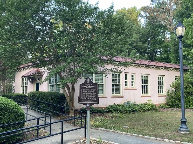
By 1924, the spread of tuberculosis had reached epidemic levels in Athens, with 100 active cases and a death toll in excess of 160. This caused public health officials to request a sanitarium (hospital) to be built. The result was a Spanish-style . . . — — Map (db m198497) HM
Named in honor of Captain Richard P. Pawson, SC, USN (Ret.) who constructed this garden from a drawing by Mrs. Mary Alice Donley
Although Captain Pawson retired after nearly
33 years of active naval duty , he continued his service to the . . . — — Map (db m198505) HM
In Memory of Charles O. Maddox 1887 – 1973 Banker, Farmer, Conservationist Purchased and held for 18 years 1800 acres of land In 1954 he transferred the land to the State of Georgia at no personal gain His vision was then fulfilled . . . — — Map (db m187403) HM
Between the Oconee & Ocmulgee In the late 1700s, the (Muscogee) Creek village of Snoden, present-day Winder, was located within the unbroken forests of Georgia's wilderness. Numerous waterways crisscrossed the landscape supplying . . . — — Map (db m187100) HM
At one time, settlers used beehive ovens to bake all kinds of foods. Taking its name from its shape, the beehive oven can be found in all parts of the world even today. They are simple to build from clay and straw so there is little or no cost — . . . — — Map (db m187401) HM
Small forts sprang up across Georgia's Indian lands during and after the Revolutionary War. The Creek, Cherokee, and other native peoples were drawn into the conflict by the British and fought skirmishes against the settlers who were establishing . . . — — Map (db m187300) HM
Settlers established farms as they arrived in new areas. They cleared forest and brush and built fences to corral their livestock, to mark their boundaries, and to keep out predators. The type of fence they built depended on available materials and . . . — — Map (db m187366) HM
Fort Yargo benefits from a group of volunteer living historians who assist in maintaining the original 1790s blockhouse structure, as well as providing demonstrations of the lifeways and skills of the late 18th and very early 19th centuries. The . . . — — Map (db m187354) HM
Fort Yargo resembles many log cabins built across the southern highlands, especially those of Appalachia. It is one and one-half stories, with front and back doors opposite to each other for air flow during the warmer months. It has a shake roof . . . — — Map (db m187400) HM
Fort Yargo's smokehouse is a reconstruction and is in use most winters. Smokehouses served to cure meat or fish with smoke and salt. Before the invention of refrigeration, fresh meat would not last very long unless it was "smoked" or frozen. In the . . . — — Map (db m187402) HM
Hal Jackson was a native of Winder, Georgia born on October 1, 1910 to J. Roy and Emma Jackson. Other than the time he served in the Army Air Force during World War II, Winder was his home. He married Katherine Adair on December 25, 1943, and they . . . — — Map (db m187287) HM
Built under the Watershed Protection and Flood Prevention Act 83rd Congress — 1954 by Barrow County, Georgia Oconee River Soil and Water Conservation District City Government of Winder Department of State Parks of Georgia with assistance . . . — — Map (db m173170) HM
The Russell House was built in 1912 by Richard Brevard Russell, Sr., B. 1861 - D. 1938, and his wife, Ina Dillard, B. 1868 - D. 1953, who were married June 24, 1891. Fifteen children were born of this marriage. Judge Russell was elected Chief . . . — — Map (db m17288) HM
Completed in 1971, Will-A-Way Recreational Area was the nation's first comprehensive outdoor recreational facility designed for people with disabilities. Beginning in 1966, the Georgia Department of State Parks met with multiple agencies to develop . . . — — Map (db m229236) HM
17,000 Years of Continuous Human Habitation
Descendants of Ocmulgee's early inhabitants, the Muscogee (Creek) people,
continue to hold these lands sacred in keeping with their traditions.
Archeological investigations conducted on this . . . — — Map (db m244420) HM
Ocmulgee's Earth Lodge - America's Oldest Ceremonial Lodge
This extraordinary piece of Mississippian architecture, the ceremonial Earth Lodge, remained buried at Ocmulgee Old Fields for 800 years until it was discovered during major . . . — — Map (db m244429) HM
The Civilian Conservation Corps (CCC) 1933-1942
Beginning in 1933, hundreds of people were employed at Ocmulgee by the various "New
Deal" public works agencies created during the Great Depression. They worked on the
archeological . . . — — Map (db m244425) HM
Flowing Artesian Well
Artesian aquifers are fed by groundwater seeping downward into the basin through cracks, often entering from miles away. The groundwater, entering from a higher elevation, exerts pressure on the aquifer and pushes the . . . — — Map (db m227252) HM
Nearby Cumberland Island is the largest and one of the most natural of Georgia's barrier islands, part of the chain of islands that stretches from Cape Code to beyond Key West. And, as a unite of the National Park System, Cumberland is yours to . . . — — Map (db m239234) HM
From roughly 1568 through 1684, twelve Spanish missions were established from St. Augustine to what is now coastal South Carolina. On Cumberland Island, the Franciscan mission San Pedro de Mocama ministered to the Native Americans. The . . . — — Map (db m144956) HM
Prior to the 1860s, commercial logging occurred primarily along navigable streams where logs could be floated to downstream ports. “Johnstone’s Mills” was clearly marked on a 1790 map of the local area and, in 1802, Archibald Clark . . . — — Map (db m145196) HM
In 1912, three canning plants began operations in St. Marys. “Davis and Brandon” had a plant near Oak Grove cemetery specializing in the preservation of local shrimp, string beans and sweet potatoes. The Hardee Brothers canned shrimp . . . — — Map (db m145206) HM
The state of Georgia issued a charter in 1856 for a St. Marys “Rail-Road” company. Shortly after Lemuel Johnson moved to St. Marys in the early 1900s, “the city of St. Marys granted land to his railroad…In 1908 the tracks . . . — — Map (db m145203) HM
The 1870s saw a county-wide boom in the production of turpentine, a resin distilled from the gum of pine trees. Gum harvesting was labor-intensive, back-breaking and conducted during the hottest, most humid time of year. After collection, the gum . . . — — Map (db m145266) HM
Today, the St. Marys River is the border between Georgia and Florida. During much of its history St. Marys was the southernmost community to separate two nations. Georgians closely watched their neighbors to the south. The fledging nation . . . — — Map (db m145199) HM
Live Oak, widely used in early American shipbuilding , made St. Marys a natural site for shipyard enterprise. Lumber from the live oak was specifically used to make curved and especially strong , structural members of the hull. In the 1790s, Col. . . . — — Map (db m145242) HM
A naturally deep river, the St. Marys was utilized by Native Americans long before European explorers documented its existence. Later, slavers, smugglers, and pirates plied the river in their tall ships and river craft, industrious in their . . . — — Map (db m144992) HM
Pre-Colonial St. Marys saw visits by European maritime powers in carracks, galleys, galleons and galeota. Historians have said that at one time up to 300 such ships lay at anchor in the St. Marys River. In the 1800s to mid-1900s, boatyards dotted . . . — — Map (db m144988) HM
Plans for the town of St. Marys, originally known as Buttermilk Bluff, were conceived by the British in 1767. The Articles of Agreement were signed on Cumberland Island in 1787 when the first American owner Jacob Weed, divided and sold land to 19 . . . — — Map (db m144903) HM
In January 1861, at Milledgeville, Georgia , St. Marys’ representatives voted for secession from the Union and formed the “Saint Marys Volunteers,” later called the “Camden Chasseurs.” All able-bodied men were sent to join . . . — — Map (db m144971) HM
Diary of Julia Johnson Fisher, Entry dated April 21, 1864
We are short allowances today. A saucer of rice and skim milk for dinner. We shock a half pint of cream in a glass jar and thus have produced our first butter—perhaps a small tea cup . . . — — Map (db m144976) HM
Gullah (the name given to the islanders of South Carolina) and Geechee (the name given to islanders of Georgia) culture is linked to West African ethnic groups enslaved on island plantations to grow rice, indigo and cotton as early as 1750. In . . . — — Map (db m145195) HM
President Harry S. Truman called The War of 1812 “the silliest damned war we ever fought. It should have been resolved through diplomacy.” Nevertheless, Congress declared war against Great Britain on June 18, 1812. The war was mainly . . . — — Map (db m145198) HM
Even though the Treaty of Ghent ending the War of 1812 had been signed on December 24, 1814, and the British had sustained a stunning defeat at the Battle of New Orleans January 8, 1815, the war still came to St. Marys. On January 13, 1815, an . . . — — Map (db m145246) HM
Prior to European settlement, Southeast Georgia was populated by Timucua Indians known as Mocama. Severely diminished due to infectious diseases and conflict, the Mocama were evacuated to Cuba by the Spanish in 1763, prior to extinction. Living . . . — — Map (db m145016) HM
St. Marys has been occupied since the mid 1500s and was founded in 1787. Within historic Oak Grove Cemetery is the final resting place of the Arcadians who were driven from Arcadia by the English. After years of sorrow, fear and loss they found . . . — — Map (db m144901) HM
These French-speaking refugees were forced to leave their homes in Nova Scotia by the British during the French & Indian War (1754-1763). The descendants of these oppressed Acadians ultimately sought refuge in St. Marys in the late 1790s after . . . — — Map (db m144939) HM
Put in place in 1810, U.S. Navy gunboats, small row-able riverboats placed in service by President Thomas Jefferson to defend home waters of the U.S., were stationed at Naval Station St. Marys/Pt. Peter. In September 1813, a Category 3 hurricane . . . — — Map (db m144924) HM
In 1979, Metter Garden Club initiated the project of replacing the small fountain in this park with a sculpture indicative of Candler County. Its vision was supported by the City government, local garden clubs, civic groups, businesses, and the . . . — — Map (db m208054) HM
Text from the Front Side of the Monument:
124th Ohio Infantry
Hazen's Brigade
Palmer's Division
21st Army Corps
Text from the Back Side of the Monument:
September 19th, 1863, this Regiment, Colonel Oliver H. . . . — — Map (db m121430) HM
Text on the Front Side of the Monument:
13th Ohio Infantry,
Dick's Brigade, Van Cleve's Division,
21st Army Corps.
Text on the Back Side of the Monument:
This Regiment, Lieutenant Colonel Elhanon M. Mast . . . — — Map (db m121770) HM
Text on the front side of the monument:
17th Regiment Indiana Mounted Infantry
1st Brigade - Wilder.
4th Division - Reynolds.
14th Corps - Thomas.
Text on the back side of the monument:
Indiana's Tribute
To . . . — — Map (db m120444) HM
Text on the front side of the monument:
1st Brigade, Wilder
4th Division, Reynolds
14th Corps, Thomas
18th Indiana Battery
Text on the back side of the monument:
Indiana's Tribute
To Her
Eighteenth . . . — — Map (db m120443) HM
Text on the Front Side of the Monument:
19th Ohio Infantry,
General Samuel Beatty's Brigade,
Van Cleve's Division,
21st Army Corps.
Text on the Back Side of the Monument:
This regiment, Lieutenant Colonel . . . — — Map (db m121677) HM
Text on the west side of the monument;
2nd Minnesota
Text on the south side of the monument;
Erected
Bt the
State of Minnesota
1893
Text on the north side of the monument;
The . . . — — Map (db m120643) HM