City Drug was the first occupant in late 1894. By
1897 McCreery & Widerfelt operated a drugstore
described as "full and complete in every particular".
Not only did they have a full line of goods, but also
a soda fountain. From 1900-1929 John D. . . . — — Map (db m232487) HM
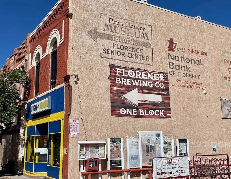
Farmers found the soil in Eastern Fremont County to be rich and fertile and perfect for growing a variety of crops. The first successful orchardist was "Uncle Jesse” Frazer. He came to Colorado during the Pikes Peak Gold Rush and found no gold . . . — — Map (db m153161) HM
After its construction
in 1928 this building
housed a J. C.
Penney's store for about
30 years. James
Cash Penney, who
came to Colorado
to fight tuberculosis,
worked as a clerk in
the Longmont
Golden Rule store, a chain
store . . . — — Map (db m232480) HM
This residence is the second home of the McCandless family and was built after he achieved substantial wealth from a variety of enterprises.
The picture taken in March 1889 shows the McCandless family. The person 4th from the left is Florence . . . — — Map (db m153123) HM
Julius McCandless, the nephew of James McCandless
was the initial owner and set up his hardware store in the
building in 1894 and lived on the first floor. He sold
farming implements, hardware, tools, mining supplies,
stoves and dishes. Julius, . . . — — Map (db m232474) HM
When the building was
completed in July, 1894,
the first occupant was
Lewis & Yost general
merchandise store. They
offered dry goods,
notions and furnishings
(everything sold at
bedrock). The firm was one
of the oldest in the city.
By . . . — — Map (db m232457) HM
The Daniels building replaced
the W. R. Daniels residence,
which was the original building
on the property. The first story
of the building consisted of two
stores. One was the W. J.
Daniels Drug Store and the
other was known as G. . . . — — Map (db m232484) HM
Florence Oil Field
Alexander Cassidy dug a twenty-three-foot-deep oil well near here in 1862, making this Colorado's first oil-producing region. Cassidy and others spent nearly two decades plumbing the hollows and seeps, sure that a major . . . — — Map (db m152994) HM
Clockwise, from top
• The Pioneer Museum in Florence highlights the town's industrial past. Ample coal and water made the town an optimal site fer processing ore shipped via the Florence and Cripple Creek . . . — — Map (db m153002) HM
When Colorado Territorial Prison opened in June 1871 just west of Cañon City, it drew a mixed reception from law-abiding locals — some daunted by the possibility of felons on the loose, others eager for the jobs and services that came with the . . . — — Map (db m152997) HM
Royal Gorge Railroad War
Racing to lay the first tracks into the Colorado Rockies in April 1878, the Denver & Rio Grande and its rival, the Atchison, Topeka & Santa Fe, reached the Royal Gorge in a dead heat. Competing construction crews . . . — — Map (db m152999) HM
On March 15, 1887, excavation for a three-story brick and stone building began on lots at 802 Grand Avenue for the First National Bank building. At the time, The Glenwood Echo newspaper reported that the First National Bank offices would occupy the . . . — — Map (db m120089) HM
The commercial building at 824-826 Grand Avenue was constructed in 1888. The brick building was initially occupied by a hardware store and an agricultural implement shop on the first floor, furnished rooms on the second floor, and a tin shop in the . . . — — Map (db m120102) HM
Beginning in the 1870's Italians came in great numbers to Colorado. The Roaring Fork Valley's Italian immigrants performed the hard, dirty work wanted by no one else. Most were coal miners who worked the mines at Sunlight, Spring Gulch and . . . — — Map (db m120548) HM
This current address has incorporated numbers 827 and 829 Grand Avenue. The earliest maps show buildings on this site since 1888, but the year 1913 has J.F. McCoy constructing his building. In 1917, the State of Colorado purchased the building for . . . — — Map (db m120087) HM
The original building at this site was built in 1883 and was called the Hotel Colorado. It was quickly found too small for its needs and plans were made to replace it.
In 1884, Isaac Cooper, William Gelder, and Joseph Enzensperger made plans . . . — — Map (db m120095) HM
The Roaring Fork Valley's coal fields sparked a war of expansion between two railroads: the Denver and the Rio Grande Railroad and the Colorado Midland Railroad. In 1886 the Colorado Midland proposed building a line to Aspen.
Knowing that . . . — — Map (db m120532) HM
In 1893, this two-story building served as a general merchandise establishment. Daniel Barry operated his business here until 1897. Cohn, Doll & Co (later Doll Bros. and Smith) operated a dry goods and general merchandise store here, followed by the . . . — — Map (db m120103) HM
This memorial is placed in honor of the men who lost their lives in the coal mines of New Castle.
Vulcan Mine - February 18, 1896
Thomas Addison·Gabriel Gleese·Angelo Petrico
Alphonz Baldis·John Gumbard·Phillip Preola
Peter . . . — — Map (db m120120) HM
Long operated by William Fick and his family, this blacksmith shop turned out a superior brand of rugged, durable quartz wagons that hauled ore from the mines to the mills along Clear Creek. The Bull Durham sign was painted by traveling artists for . . . — — Map (db m51883) HM
The major fire in Central City on May 21, 1874 nearly wiped out the commercial district of the city. The new building was completed by November 1st of the same year and B.F. Pease operated a dry goods store at the location for nearly 10 years. For a . . . — — Map (db m51834) HM
In 1881 James Cairns built his first store here to serve the miners. In 1908 he replaced it with a better building, purchased by Matilda Humphrey in 1924. It survives as the central part of the Humphrey store. The small residence was Cairns interim . . . — — Map (db m129850) HM
Entrepreneur P.H. Smith brought his family to Grand County from Kansas. In 1893 he started a sawmill in Grand Lake and acquired several local properties.
A skillful craftsman, P.H. Smith built many significant structures, including the Grand . . . — — Map (db m129883) HM
The Smith Eslick Family (panel 1)
Entrepreneur P.H. Smith brought his family to Grand County from Kansas. In 1893 he started a sawmill in Grand Lake and acquired several local properties.
A skillful craftsman, P.H. Smith built many . . . — — Map (db m129880) HM
Used for grinding ore rocks, preparing
them for the mill. This type of rock crusher
had a bell shaped object in the crushing
mechanism that turned and when rocks were
poured into the hopper the bell shaped object
would turn, thus . . . — — Map (db m158584) HM
Built in 1882 by Baldwin Class C-16 2-8-0
Worked in Gunnison for 73 years (1882-1955)
Fire put out for the last time on July 1, 1955
The paint scheme on the engine was done in 1949
for the Chicago Railroad Fair. Later #268 appeared
in . . . — — Map (db m158567) HM
[Clockwise from top right]
Glenwood Canyon. In 1993 the Colorado Department of Transportation completed the final link of Interstate 70 through this remarkable canyon.
Glenwood's Natural Hot Springs have soothed and healed human ailments . . . — — Map (db m158790) HM
"If I get through it will be a triumph-
but I must try at least and try I shall."
John W. Gunnison, 1853
1853 Gunnison Railroad Expedition
In 1853 Capt. John W. Gunnison (1812-1853) led a survey party through the Central Rockies . . . — — Map (db m158720) HM
The Coal Miners
Crested Butte's early miners were mostly Anglo-Saxons from Cornwall, Wales, Scotland, and Ireland. This changed in the 1890s when the mines were worked by cheap labor drawn from southern Europe—Slavs, Greeks, and . . . — — Map (db m158787) HM
Used to dig potatoes from the ground.
Note the bars in the back of the machine.
These bars when in operation would vibrate
the excess dirt off of the potatoes. — — Map (db m158613) HM
Note the knives at the bottom of the
potato bin, which sliced the potato before
it dropped into the ground. Potatoes were
grown in Gunnison in the early pioneer days.
Donated by the
Jim and Zeta Graham Family
in memory of Partick . . . — — Map (db m158642) HM
Thunder in the Black Canyon
The Black Canyon thwarted explorer John W. Gunnison, and years later railroad engineers declared it impassable. But General William Jackson Palmer, president of the Denver & Rio Grande Railway, believed his men . . . — — Map (db m158726) HM
Used in placer mining. By pouring water over the mined material, the heavier metals such as gold or silver sink to the bottom for easy retrieval. This item would be an industrial type water pump. — — Map (db m158588) HM
Burrows Park, Argentum, or Whitecross the name may have changed, yet the community and its place in history have remained the same. Situated within a five-mile long grassy meadow known as Burrows Park, clusters of hotels, blacksmith shops, . . . — — Map (db m177915) HM
The history of the Bonanza Empire Chief Mine and Mill mirrors the stories told of fleeting fortunes throughout the San Juan Mountains. The initial discovery of the Bonanza Lode was made on July 4, 1885. Little work was completed on the claim until . . . — — Map (db m177867) HM
George S. Lee arrived in Hinsdale County from Massachusetts in May, 1877 with ambitious plans for the newly formed Galena Mining District. Lee saw opportunities to invest in the future of Colorado. At the time, the two-hundred-acre town site known . . . — — Map (db m177868) HM
Rose Lime Kiln was built along the banks of Henson Creek in the spring of 1881 by local investor and businessman George S. Lee. At the time, Lee used rare technology that he believed would dramatically change construction material and development. . . . — — Map (db m176748) HM
Tellurium's history, like that of many mining camps, consisted of booms and busts. From its initial occupation in 1875, it boasted as having two groceries and a post office (1876), but in an unusual statement for a mining camp, it did not have a . . . — — Map (db m177910) HM
Living conditions were often deplorable in the Galena Mining District. Miners often lived in company supplied boarding houses set up in close proximity to the mines. The houses were poorly built, drafty, and had leaky roofs. Although conditions at . . . — — Map (db m177890) HM
As the primary impetus of Lake City's initial boom and the mainstay of its survival through the mid-1900s, the Ute-Ulay Mine and Mill Complex is linked to Hinsdale's county seat and only incorporated town emotionally and irrevocably. Architecture . . . — — Map (db m177908) HM
At 2:14 AM on March 24, 1929, the Big Slide on the north side of Gravel Mountain tore loose and buried the Bonanza Empire Chief main office building, a dining hall/bunk house, and a five-room bunkhouse. Two cooks - Mrs. Mayme Watson and Mrs. E.L. . . . — — Map (db m177866) HM
The first Euro-Americans ventured into North Park in search of
beaver pelts. These pelts were used to satisfy a fashion craze for
beaver hats in Europe. By 1820, fur trappers were working along
the mountain streams in and around North Park. . . . — — Map (db m240738) HM
Dating from 1878, when Leadville butcher Reid Mathews used
the valley's abundant grass to fatten his cattle during the
summer, ranching is the oldest continuous industry in North
Park. Many other cattlemen followed, drawn to the area in . . . — — Map (db m240751) HM
Rumors of the existence of precious metals in North Park
began when John C. Fremont's expedition passed through
the valley in 1844. However, it was nearly thirty years later
that prospecting took place in North Park. Canadian James
O. . . . — — Map (db m240743) HM
As mines expanded and North Park's
population swelled, there was an increasing
need for timber to shore up the mines and
to build homes for settlers. The abundant
forests surrounding North Park afforded a
ready supply of timber, and logging . . . — — Map (db m240737) HM
City of Golden
Downtown Landmark
The Stewart Block building was completed in 1892. It served as a grocery for 52 years under a variety of owners including Caleb E. Parfet, Elvyn E. Stewart, and Leonard Vogel. The motto of the original building . . . — — Map (db m50593) HM
In this immediate area once stood
Arapahoe City
A pioneer placer mining camp the earliest town in Jefferson County. Named for the Arapaho Indians. Town company organized Nov. 29, 1858. From here went George A. Jackson and John H. Gregory . . . — — Map (db m82878) HM
In 1867, in Hamburg, Germany, young Adolphus Herman Joseph Kuhrs was preparing to stow away on a ship bound for America. By 1872, Coors had altered the spelling of his last name and arrived in the Denver area. He settled on Golden because of its . . . — — Map (db m74796) HM
Golden had a variety of businesses and industries in operation during the late 19th and early 20th centuries. Among these were four flour mills-the Rock Mill, the Brick Mill, the Binder Mill, and the Golden Mill. Mill races, or ditches dug from . . . — — Map (db m50596) HM
John M. Ferrell came to the Golden valley from upstate New York in June of 1859. He camped on the southeastern banks of Clear Creek and created the Washington Avenue crossing for the gold rushers. When Golden was organized, Ferrell became one of its . . . — — Map (db m49895) HM
In the mid-19th Century, prospectors coming into the Clear Creek valley discovered placer gold that had been carried downstream from mountain deposits. As the sandbars containing the placer gold were mined out, prospectors traced the fold upstream . . . — — Map (db m49907) HM
From the mid-1800s, to the mid-1900s, gold mining and dredging represented an economic boon to the Clear Creek region.
In 1904, the National Dredging Company, led by Herman J. Reiling, purchased the historic Arapahoe Bar in Clear Creek, which had . . . — — Map (db m50601) HM
In Golden's early days this area was called Goosetown neighborhood. The origin of the name is uncertain. The first residents were mostly German immigrants who worked at local breweries, rail yards and smelters. Their homes were simple, wood frame . . . — — Map (db m82881) HM
In May of 1949, Bill and Dorothy Harmsen purchased an ice cream machine and leased a storefront on the east side of Washington Ave. The Harmsens chose the name Jolly Rancher for their store to reflect a spirit of western hospitality. High quality . . . — — Map (db m49893) HM
With temperance pressures rising, Adolph Coors knew diversification was crucial to his industry. In 1910, he invested in John J. Herold’s pottery works at 8th and Ford Streets. During the middle of the decade, embargoes on German import porcelain . . . — — Map (db m50090) HM
Here is a story from the Colorado Transcript of August 12, 1885:
“We like to hear a good story, and here is one on Jim Boyd: Last spring Jim’s wife wanted to peddle vegetables in Denver. Jim laughed at her, believing she could not even . . . — — Map (db m49910) HM
Laramie Formation
Sandstone ridges still stand south of 12th Street between the mined out clay areas (Fig. 4). The clays used for bricks and tiles were mined by the Parfet family beginning in 1877.
The Clay Pits Fault is exposed on the . . . — — Map (db m152806) HM
In the late 1800's, the White Ash mine was the largest coal mine in Colorado. Its livelihood dominated Golden and overshadowed even the famous Coors brewery. It produced some of the best and hottest burning coal and was named for the white ash that . . . — — Map (db m152780) HM
The Astor House opened in 1867 and stayed in continuous operation as a boarding house until the late 1960s. It offered rooms and hot meals to lawmakers, laborers, miners, students, and families, some of whom stayed for weeks or even months.
Over . . . — — Map (db m152730) HM
For many years, Golden’s people have respected the flood waters of Clear Creek above ground. However, it was the flood below ground that claimed the most lives. On September 9, 1889, water broke into the White Ash Mine beneath Clear Creek at the . . . — — Map (db m49900) HM
Devoted family man and visionary businessman.
John Brisben Walker is personally responsible for the way much of the front range looks in this area. In his quest for the perfect place to build a home for his family, he preserved thousands . . . — — Map (db m141095) HM
Red Rocks Park is a national Historic District on the National Register of Historic Places. The Trading Post and the Amphitheater are Denver Landmarks. The Trading Post, an example of the Pueblo-style architecture, is made of brick and stucco and . . . — — Map (db m57641) HM
In January of 1914, L. E. Jenkins bought the lot at the corner of Mill and Pearl Streets. In February he started construction on this building and hired J. M. Lail as his contractor. According to the Bayfield Blade, L. E. Jenkins was in his new . . . — — Map (db m160497) HM
This property was owned by Warren Schiller, co-founder of Bayfield. In 1898, the property was leased to F. M. Anderson, upon which he built a restaurant. A photograph from the 1910s shows a false-front wood frame building with clapboard siding on . . . — — Map (db m160557) HM
H.C. Schroder bought [this] property at the end of 1899 and by 1900-1901 he had constructed a flour mill and a retail store on the property; it is likely that he built this house at the same time. The Beach family owned this house from June 1925 . . . — — Map (db m160496) HM
Hotel Central
57 W. Mill Street
The August 3, 1911 edition of the Bayfield Blade reported the completion of the "Hotel Central." This photo shows the building originally had wood clapboard siding, a wood shingle roof, and a covered . . . — — Map (db m160490) HM
Schroder Store
64 W. Mill Street
(Second from left)
The November 7, 1901 Durango Democrat reported that H. C. "Schroeder" was building a new storehouse in Bayfield; this is the west half of this building. Between 1910 and 1919, additions . . . — — Map (db m160471) HM
has been designated a
Registered National
Historic Landmark
under the provisions of the
Historic Sites Act of August 21, 1935
This site possesses exceptional value
in commemorating or illustrating
the history of the United . . . — — Map (db m160243) HM
A majority of the buildings visible in this photo were destroyed in the fire of 1889. The nearest block featured a wide variety of businesses, including the Grand Central Livery, the building on the right. A look down Main shows smelter smoke . . . — — Map (db m160299) HM
The first Rocky Mountain
Chocolate Factory was opened
on this site in May 1981. With
the support of the people of
Durango and her visitors,
Rocky Mountain Chocolate
Factory, Inc. has grown to
become an international
franchisor with . . . — — Map (db m160240) HM
The large building in the foreground is Durango's first high school. Above it is the new La Plata County Courthouse. The Boulevard, today's Third Avenue, is the street running between the two. The Ladies' Literary Society planted trees in the . . . — — Map (db m160451) HM
Trails & Passes
• The Colorado Rocky Mountains, appearing as a formidable barrier, have trails over almost all 260 passes.
• A trail is a corridor between two places: usually a network of paths that meet at certain key points, such as river . . . — — Map (db m153407) HM
Stony Pass
• From 1872 until 1882, when the railroad reached Silverton, Stony Pass was the vital link between the San Juan mining districts and supply towns to the east.
• A practical but tough route from Del Norte ran up the Rio Grande . . . — — Map (db m153409) HM
Between 1800 and 1850, the Old Spanish Trail became a regional trade route between Santa Fe and California.
Dominguez and Escalante traveled through this valley in 1776. Within twenty-five years of their expedition this trail became a . . . — — Map (db m218222) HM
This place has seen plenty of changes since Charles Senter discovered a deposit of molybdenum on Bartlett Mountain in 1879.
In the early days, Climax was a sleepy depot at the top of a railroad grade. But by World War I there was a . . . — — Map (db m122841) HM
Colorado 91 is now a well-engineered modern highway, but driving over Fremont Pass wasn't always as safe or convenient as it is today.
The silver mining boom created a population of more than 30,000 people in Leadville by 1879, making it the . . . — — Map (db m122827) HM
The sound of a train whistle was music to the ears of a miner spending the winter on Fremont Pass. Up until just before World War II, Colorado 91 was a dirt track that was closed six months a year, and the railroad was the mine’s only link with the . . . — — Map (db m122839) HM
It's only a memory now, but the community of Climax was once called home by several generations of Colorado mining families.
In its early years, Climax struggled to keep quality employees. Cold and snow, isolation and high altitude sent many . . . — — Map (db m122837) HM
One of the most significant technological advances in Climax Mine history was the implementation of block-cave mining in 1927. It cut the production cost of molybdenum in half, keeping the mine open (and profitable) through the grim years of the . . . — — Map (db m122838) HM
Eighty years of mining operations on Fremont Pass disturbed more than five square miles of land and altered the course of a stream. As of 2009, Climax Molybdenum Company had spent nearly $50 million on land reclamation and water treatment. Not a . . . — — Map (db m122835) HM
By the time Charles Senter staked his claims on Bartlett Mountain in 1879, the trout were gone from Ten Mile Creek. It had been altered by smelting and mining that took place long before Climax began operations. Today, the trout are back.
. . . — — Map (db m122749) HM
A whole lot of Colorado history has happened right here on top of Fremont Pass. And it all happened because of a metal most people have trouble pronouncing.
Molybdenum (moll-ib-den-um) is used to harden steel.
More molybdenite ore (the . . . — — Map (db m122900) HM
The nationwide
May Department Stores
mercantile empire was born
in September, 1877 when
David May
opened his first store in a tent
300 feet south of this tablet.
From 1881 to 1888 the May Store
occupied this site, at 318 . . . — — Map (db m51809) HM
This aerial photograph shows the Bellvue Laboratory in the 1920s. The US Department of Agriculture developed the site as a field laboratory for research on irrigation technology. Here former Colorado Agricultural College (now Colorado State . . . — — Map (db m176232) HM
This property, part of the original Camp Collins, was purchased by the Mosman family on October 5, 1891. In 1892 prominent architect, Momtezuma Fuller (1858-1925) designed this house, in a distinctive Eastlake Victorian Queen Anne architectural . . . — — Map (db m52324) HM
A stage station, post office, and hotel, on the route from Fort Collins, by way of Pingree Hill, to Home, Colorado, in the upper Poudre Canyon.
In memory of Mildred Payson Beatty — — Map (db m173076) HM
Downtown Loveland Historic District has been placed on the National Register of Historic Places by the United States Department of the Interior March 2015
The downtown Loveland historic district encompasses portions of nine square blocks . . . — — Map (db m222002) HM
Farmhand to Cattle Baron Eugene Rourke was born on St. Patrick's Day in 1849 in Wicklow County, Ireland. The younger of 10 children, Eugene and his
family immigrated to La Salle, Illinois in 1852. Tragically, his
parents died . . . — — Map (db m181884) HM
Most miners lived in company-owned towns like Berwind.
The miners often lived in company-owned towns near the mines where they worked.
Because of their isolated location, miners were forced to buy provisions at company stores, live in . . . — — Map (db m193636) HM
Even though conditions were harsh, colonists forged friendships and a sense of community.
Approximately 1200 people lived in 200 tents made of canvas and wood.
Based on excavations, tents averaged 10 x 14 feet in size and were . . . — — Map (db m193627) HM
History often neglects or omits the 1913-1914 Colorado coalfield strike and massacre
Looking onto this prairie, you see one of several places where coal miners lived during the strike.
Miners demanded better wages, an eight-hour work . . . — — Map (db m193668) HM
Engine 638 was manufactured in 1906 and put into service with the Colorado & Southern R.R. for service at Trinidad for hauling coal, cattle, agricultural products and general merchandise.
Later the engine saw service in other areas of . . . — — Map (db m116849) HM
323 entries matched your criteria. Entries 101 through 200 are listed above. ⊲ Previous 100 — Next 100 ⊳