141 entries match your criteria. The first 100 are listed. The final 41 ⊳
Appalachian Iron Furnaces Historical Markers
Beginning in the 1700s converting iron ore into iron took place at isolated iron works close to ore sources. They were abandoned when raw materials were depleted, leaving their pyramidal stacked-stone furnaces to history.
On Furnace Road (County Road 62) south of Montevallo Road (State Route 25).
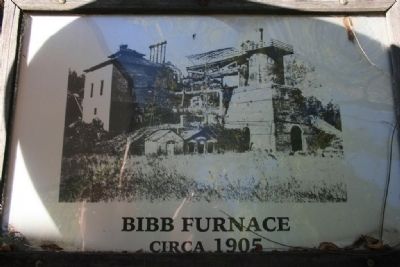
The Bibb County Iron Company under the direction of C. C. Huckabee of Newbern, Alabama, constructed a furnace here and poured the first iron in November 1862. Within a year, the Confederate government purchased the works and completed a second and . . . — — Map (db m37090) HM
On Janney Road, 0.1 miles east of Spring Road, on the left when traveling east.
The furnace was constructed by Montgomery businessman Alfred A. Janney, reportedly using slaves brought from Tennessee by a "Dr. Smith." The furnace was completed and ready to produce pig iron when, on July 14, 1864, a Union cavalry raiding force of . . . — — Map (db m25544) HM
The Confederate States of America in 1862 commissioned the Noble Brothers of Rome, Georgia to erect a cold blast furnace to produce needed pig iron for the war effort.
The skilled labor was detailed from Confederate army personnel. It is . . . — — Map (db m83267) HM
On County Route 29 at County Route 45, on the right when traveling north on County Route 29.
Put into blast on June 1, 1874, the furnace would change ownership two times prior to being purchased by the Bass Foundry and Machine Co. of Fort Wayne, Indiana in 1880. A rail spur was built from the furnace to Selma, Rome and Dalton Railroad at . . . — — Map (db m114842) HM
On Stone River Road north of Old Leeds Lane, on the left when traveling north.
Wallace S. McElwain (1832-1888)McElwain trained in a gun factory in New York and in a foundry in Ohio before moving to Holly Springs, MS, where he operated Jones, McElwain and Company Iron Foundry. He was well known in the Southeast for his . . . — — Map (db m26266) HM
On Parkway Drive at North Mall, in the median on Parkway Drive.
Operated on this site under the ownership of seven companies to produce foundry pig iron. Supplied pig iron during World War 1. Closed for the last time in the Spring of 1919. Dismantled in 1933, and the land sold in 1935 for a Federal Housing . . . — — Map (db m26229) HM
On South Main Street at Mildred Street, on the right when traveling north on South Main Street.
Major source of pig iron for the Confederacy. Furnished iron to Selma arsenal for heavy cannon, naval armor plate.
Furnaces destroyed in 1865 by Wilson’s Cavalry raiders U.S.A.
Rebuilt 1873, closed 1923. — — Map (db m28523) HM
On Bucksville Road (Alabama Route 216) east of Interstate 59/20, on the right when traveling east.
2 ½ miles East - the beginning of Steel Industry in this area. Iron Ore, reduced by charcoal, hauled by oxcart, was made into plows, pots, cannon and munitions.
State Park- Camping, Nature Trails, Swimming and Fishing Early American . . . — — Map (db m36927) HM
Tannehill Furnaces began as a
small forge in 1830. During the
War Between the States (1861-1865)
these furnaces were a major
supplier of iron and munitions
for the Confederacy. When
partially destroyed by Union
troops on March 31, . . . — — Map (db m36926) HM
Near Lower Road at Furnace Hill Road, on the left when traveling west.
What Is This Place?
Beckley Furnace Industrial Monument
You are standing in front of the remains of an iron furnace. This facility, Beckley Furnace, operated from 1847 until 1919, making it one of the last of its kind to operate in the United . . . — — Map (db m41975) HM
On U.S. 60 at Old River Road, on the left when traveling west on U.S. 60.
Caney Furnace
Stood five miles south. This stone stack, built 1837-38 by Harrison Connor and Joshua Ewing, Sr., was among first iron furnaces west of the Alleghenies to be equipped with a hot-blast oven, a device to preheat the air blown . . . — — Map (db m110123) HM
On Kentucky Route 36, on the left when traveling north.
Bourbon Iron Works Jacob Myers from Richmond, Va. took up land grants here on Slate Creek, 1782. He built the first iron blast furnace in Ky., 1791. John Cockey Owings and Co. formed to operate furnace. Utensils and tools supplied settlers. . . . — — Map (db m110121) HM
On Main Street (Kentucky Route 211), on the right when traveling north.
Clear Creek Furnace
Built in 1839, 5 miles south, by W. A. Lane and W. S. Allen. Stone stack originally 40 ft. high and 10 1/2 ft. across inside, burning charcoal. Air blast powered by steam. Its iron was used mainly for railway car wheels. . . . — — Map (db m110122) HM
On Winchester Avenue (Business U.S. 23) at 23rd Street, on the left when traveling east on Winchester Avenue.
NORTON FURNACE. In 1967, the world’s oldest known operating blast furnace. Built by Norton Iron Works Co. in 1873, an iron shell stack 67 ft. high with maximum inner diameter of 18 feet, burning “stone coal.” It produced 10,502 tons . . . — — Map (db m128281) HM
On Bellefonte-Princess Road (Kentucky Route 5) at Princess Drive and Oxcart Road, on the left when traveling south on Bellefonte-Princess Road.
Bellefonte Furnace. The most successful of pioneer
Kentucky charcoal furnaces in the
Hanging Rock Iron Region. Built
by Archibald Paull, George Poague
and others in 1826. Its stone
stack was 34 feet high with a
maximum inner diameter of . . . — — Map (db m126468) HM
On Kentucky Route 5 at Straight Creek Road, on the left when traveling north on State Route 5.
Buena Vista Furnace Built by William Foster and Co. in 1847, 2¼ miles west, named for Mexican War battle that year. It was an important factor in the Hanging Rock iron industry until dismantled in 1876. Its 1874 production was 4113 tons. Stone . . . — — Map (db m126266) HM
On Kentucky Route 5 at Princess Drive, on the left on State Route 5.
Princess Furnace. Built here in 1876-77 by Thomas W. Means (1803-90), for 50 years the leading figure in the iron industry of this area, owner of furnaces in Kentucky, Ohio, Virginia, Alabama. This iron-jacketed stack burned “stone . . . — — Map (db m126230) HM
On Kentucky Route 3 just south of Bolts Fork Road (Kentucky Route 773), on the left when traveling south.
Sandy Furnace. Built 1853 by Young, Foster & Co
(Dan and John Young, William Foster,
Irwin Gilruth), 4 miles west on a
9,000 acre tract. Stone stack
originally 32 ft. high, 10½ ft.
across inside. In 1854, its last
year of operation, . . . — — Map (db m126132) HM
On Preston Highway (Kentucky Route 61) at Beech Grove Road (County Route 1494), on the left when traveling north on Preston Highway.
Stood one mile west. It was a stone stack 33 ft. high with a maximum inner diameter of 10 ft. Its fuel was charcoal, and its air blast machinery was driven by a steam engine, blowing preheated air through the stack. Built in 1832, perhaps by John H. . . . — — Map (db m122030) HM
On Pioneer Drive, 1 mile south of East Pioneer Drive, on the left when traveling south.
Belmont Furnace
Stone stack 500 yds. east, 33 ft. high originally, 10 ft. across inside. Built in 1844, perhaps by John H. Baker, rebuilt in 1853, it burned charcoal fuel, smelted iron ore from Cane Run. The air blast machinery was powered . . . — — Map (db m174393) HM
On State Highway 121 at Cypress Trail, on the right when traveling north on State Highway 121.
Gerard Furnace Built 2¼ miles east in 1854 by Browder, Kentucky and Co. Inside it was 24ft. high and 10½ ft. across at widest point, burning locally made charcoal fuel. Its air blast machinery was powered by steam. In 34 weeks of 1857, it . . . — — Map (db m37941) HM
On West 5th Street (Kentucky Route 8), in the median.
Built three blocks east in 1859 by Swift's Iron and Steel Works. As rebuilt in 1869, it was 65 feet high, with a maximum diameter inside of 16 feet. Its annual capacity was 17,000 tons of iron, using Connellsville coke as fuel. Iron mostly converted . . . — — Map (db m49114) HM
On Hitchens Road (Kentucky Route 1) south of East Main Street (U.S. 60), on the right when traveling south.
Six miles south, site of famous iron
furnace, erected, 1848, by R. M.
Biggs and others. Operated 37 years,
averaging 15 tons pig iron daily
which was hauled by ox teams to
Ohio River for shipment. Iron
produced here was used for rails,
plows, . . . — — Map (db m144955) HM
On Carol Malone Road (Kentucky Route 1) 1 mile north of Interstate 64, on the right when traveling south.
Pactolus Furnace Built in 1824 by Joseph McMurtry and David L. Ward, on the site of an earlier bloomer forge. Its stone stack used charcoal fuel, and its air blast machinery was powered from a dam, 5 1/2 ft. high, in Little Sandy River. Capacity . . . — — Map (db m73787) HM
On U.S. 60 just west of Clay Hollow Road, on the left when traveling west.
Built in 1848 by A. McCullough and Lampton Brothers. Its stone stack was 36 feet high. 11½ feet across inside at widest point, and burned “stone coal” rather than charcoal. It was served by its own railroad spur. In 1866 it produced . . . — — Map (db m144425) HM
Buffalo Furnace
A major producer of iron in the Hanging Rock Region 1851-75, an important Union Army supplier in Civil War. Built by H. Hollister and Ross. Stone stack originally was 36 ½ feet high, with a steam powered air blast. . . . — — Map (db m73782) HM WM
Iron made in Kentucky. A major producer since 1791, Ky. ranked 3rd in US in 1830s, 11th in 1965. Charcoal timber, native ore, limestone supplied material for numerous furnaces making pig iron, utensils, munitions in the Hanging Rock, Red River, . . . — — Map (db m73778) HM
On Kentucky Route 1 north of Big Lost Creek Road (Kentucky Route 784), on the right when traveling north.
Hopewell Furnace. In 1824 William Ward built here a bloomery forge, converting it, 1832-33, to a blast furnace, also known as Camp Branch Furnace. Air blast was water-powered. In 1838 this stone stack made 600 tons of ore, and burning 165,000 . . . — — Map (db m126324) HM
On Kentucky Route 7 at Brushy Road, on the right when traveling south on State Route 7.
Built 6 miles west in 1846 on a tract of 30,000 acres by Samuel Seaton and others. Stone stack is 35 feet high, 10 feet across inside. Charcoal fueled, steam-powered air blast. In 22 weeks of 1854, produced 970 tons of iron, hauled in pigs by . . . — — Map (db m144394) HM
On Kentucky Route 1 at Laurel Road, on the left when traveling north on State Route 1.
Laurel Furnace. Built 4 miles west by George and Samuel Wurts in 1849. The bottom half of the stack, originally 39 feet high, is carved from one block of stone cliff. Maximum inner diameter 10½ feet. It made 2150 tons of iron in 31 weeks . . . — — Map (db m126328) HM
On U.S. 23 at Legion Drive, on the right when traveling east on U.S. 23.
Caroline Furnace. Stood 1½ mi. south. Built 1833 by
Henry, Blake & Co. Stone stack was
35 ft. high, with a maximum inner
diameter of 10 ft.; burned charcoal.
Air blast powered by steam. In
1838, produced 750 tons of iron,
consuming . . . — — Map (db m126406) HM
On U.S. 23 west of Ashland Drive (Kentucky Route 1725), on the right when traveling east.
Amanda Furnace. A stone stack 35 feet high, 10 feet across inside, built in 1829 by James E. McDowell, John Culver, John H., Edwin P., Robert C., and William L. Poage; later owned by the Paull family, buried on the hillside above. In 196 days . . . — — Map (db m126467) HM
On U.S. 23 at Little Rocky Road (Kentucky Route 1043), on the right when traveling east on U.S. 23.
Enterprise Furnace stood 6 miles south. Built, 1826, by Richard Deering, James McCoy and Jacob Clingman, on the site of a bloomery forge erected in 1824. Its air blast was operated by water power, and it burned charcoal fuel, producing as much . . . — — Map (db m144390) HM
On U.S. 31E at Aetna Furnace Highway (Kentucky Highway 936), on the right when traveling north on U.S. 31E.
Built in 1816, first iron furnace in western half of Kentucky. Salt and iron sought by early settlers. Charles Wilkins, Ruggles Whiting, and Jacob Holderman were partners in this furnace until 1826, when Holderman became the sole owner. Property . . . — — Map (db m96819) HM
On Main Street (U.S. 31W) at East Union Street (State Highway 357), on the left when traveling south on Main Street.
Henry Clay Furnace
Built 7¼ miles east in 1832 by Aylette Hartswell Buckner, S.V. Leedom, Cadwallader Churchill. A stone stack about 35 ft. high, 9 ft. across at widest inside, it burned charcoal fuel to produce pig iron and utensils from . . . — — Map (db m39942) HM
On Kentucky Route 2565 north of Kentucky Route 644, on the right when traveling north.
Pioneer Furnace
The southernmost blast furnace in the Hanging Rock Iron Region. Built in 1881, 4½ miles south, by Jay H. Northup, George C. Peck and Thomas Cummings. A stone stack 18 ft. high with a maximum inner diameter of 4½ . . . — — Map (db m136981) HM
Grand Rivers Furnace.
Built ½ mile west, 1890-91, by the Grand Rivers Coal, Iron and Railroad Co. Two stacks, each one 60 ft high with a maximum inner diameter of 13½ ft., together could produce 45,000 tons of iron yearly, using . . . — — Map (db m47239) HM
On Old Ferry Road (Forest Road 117) at Forest Road 122, on the right when traveling north on Old Ferry Road.
Mammoth Furnace
Built ¾ miles west in 1845 by Charles and John Stacker, a stone stack 31½ ft. high, 9 ft. across inside at widest. Steam-powered, charcoal-fueled, it made white, unusually hard pig iron from ore deposits near furnace, . . . — — Map (db m169129) HM
On Kentucky Route 810 south of Rusty Ridge Road, on the right when traveling south. Reported damaged.
Here William Kelly (1811-1888) discovered a steel making method, later known as the Besssemer process, which made it possible for civilization to pass from the Iron Age to the Steel Age. — — Map (db m169125) HM
On Lake Barkley Drive (Kentucky Route 295) south of Mint Spring Drive, on the left when traveling south.
Eddyville Furnace
Also, called Jim and I. A brick
blast furnace for smelting iron,
burning charcoal fuel, built 1832
by John and Samuel Stacker, and
Thomas Tennessee Watson. Later
owned by members of Cobb family,
then by William Kelly, . . . — — Map (db m169120) HM
On Kentucky Route 810 near U.S. 62, on the right when traveling south.
Suwanee Furnace. Built by 1851, 200 yds. NW, by William Kelly, whose experiments there perfected his invention of the so-called Bessemer method of making steel, for which Kelly was granted the patent. The blast furnace was a brick stack 35 ft. . . . — — Map (db m123677) HM
On South 3rd Street (Business U.S. 60) at Norton Street, on the left when traveling south on South 3rd Street.
Paducah Furnace
Built here 1889 by Paducah Iron Co., 70 ft. high with a maximum inner diameter of 14 ft. Rated annual capacity 30,000 tons of iron, using coke fuel. Operations began in 1900, smelting ore from Lyon, Trigg, Livingston Counties in . . . — — Map (db m158741) HM
On Old Beaver Road (Kentucky Route 1274) 6.4 miles east of Kentucky Route 36, on the right when traveling east.
Erected in 1819 by J. T. Mason.
it began operations under Robert
Crockett, ironmaster. The furnace
was a big truncated pyramid of
sandstone blocks, 35 feet high
with a 28 foot square base. Some
products: nails, “plough . . . — — Map (db m146658) HM
On John Prine Avenue (U.S. 431) north of East Mose Rager Avenue (State Route 176), on the right when traveling north.
Airdrie Furnace Site
East 5 miles. Furnace, 55 ft. high, and stone machinery house built by Robert Alexander, 1855. Brought in Scottish workers, unfamiliar with American ores. Never produced any salable iron. Alexander named town of . . . — — Map (db m123517) HM
On East Main Street (Maryland Route 36) at Bridge Street, on the right when traveling south on East Main Street.
Named to the National Register of
Historic Places — June 19, 1973
Presented by the Preservation Society
of Allegany County, Inc.
May 1974
— — Map (db m139084) HM
On Catoctin Furnace Road (Maryland Route 806) at Red Bird Lane (Route 806), on the right when traveling south on Catoctin Furnace Road.
An important iron furnace during the revolution owned by Governor Thomas Johnson and his brothers. Furnished 100 tons of shells used at Yorktown. — — Map (db m1530) HM
On Catoctin Furnace Road (Maryland Route 806) south of Red Bird Lane, on the right when traveling south.
The original Catoctin Furnace, located nearby on Little Hunting Creek, was in blast by 1776 and delivered 958 ten inch bombshells weighing over 31 tons to Washington’s Continental Army in 1780. A great number were used in the siege of Yorktown a . . . — — Map (db m61259) HM
On Blacks Mill Road at Catoctin Furnace Road (Maryland Route 806) on Blacks Mill Road.
When Union Gen. John F. Reynolds’ I Corps marched by here on June 29, 1863, en route to Emmitsburg and soon to Gettysburg, his men were progressing “swimmingly.” The workers of the Catoctin Furnace had little time to notice, since the charcoal . . . — — Map (db m105249) HM
Near Park Central Road north of Foxville Road (Maryland Route 77), on the right when traveling north.
The charcoal was made. The cutters and wood haulers were done. The air was beginning to clear. Now the colliers had to make sure the teamsters transported the charcoal downhill to the Catoctin Iron Furnace with their mule-drawn wagons.
For . . . — — Map (db m121161) HM
On Maple Street at Water Street, on the right when traveling west on Maple Street.
The land occupied by Wilderness Voyageurs was once the site of the livery stable for the Riverside Hotel. The house pictured above was the home of Captain Elijah Monroe Friend, grandson of Gabriel Friend, son of John Friend the first white . . . — — Map (db m153156) HM
On Main Street (New Hampshire Route 116) 0.1 miles south of Sugar Hill Road (New Hampshire Route 117), on the left when traveling north.
Across the Gale River stands New Hampshire's sole surviving blast furnace. It is unusual, as well, in its octagonal shape and its remarkable condition.
A huge wooden shed protected the furnace and workers from the weather. The shed filled . . . — — Map (db m116364) HM
On Main Street (New Hampshire Route 116) 0.1 miles south of Sugar Hill Road (New Hampshire Route 117), on the right when traveling south.
Due west stands New Hampshire's sole-surviving example of a post-Revolutionary furnace for smelting local iron ore. The industry flourished during first half of 19th century. It produced pig and bar iron for farm tools and cast iron ware, including . . . — — Map (db m116365) HM
Near Greenwood Lake Turnpike, on the right when traveling west.
The stone foundation before you is all that remains of the original iron furnace at Long Pond Ironworks. Built in 1766 by Peter Hasenclever, it was 25 feet tall and could produce 25 tons of iron a week. During the Revolutionary War, iron . . . — — Map (db m65913) HM
Catalan Forge Furnace - 1881
Standish (Williamstown) made brick-like blooms from one of Saranac River Mines
1886 - Replaced by blast furnace & ore from Lyon Mt. — — Map (db m57311) HM
On New York State Route 9 north of South Junction Road, on the right when traveling south.
Erected in 1809 by Alfred Keith. First on Lake Champlain in northern NY State. Operated by Keith 1809-1822, Jacob Sax 1822 until destroyed by the flood of 1830. — — Map (db m108644) HM
In 1845, Lemuel Pomeroy II, a prominent gun manufacturer from Pittsfield, Massachusetts, and his sons, established the Copake Iron Works here at the western edge of the Litchfield Iron District. The site offered all the resources essential for iron . . . — — Map (db m135768) HM
Near Old Forge Rd close to Sterling Lake Road, on the left when traveling north.
This tablet was erected by the Daughters of the Revolution State of New York June 23, 1906 To commemorate the ruins of Sterling Furnace Which was built on this spot in 1751. This furnace is believed to have been the first place in the State of New . . . — — Map (db m180865) HM
Near Shepherd Mill Road, on the right when traveling east.
During the Civil War, the Confederacy relied on small rural ironworks for the metals needed to manufacture cannons, swords, and firearms. The furnace here, owned by the Moratock Mining and Manufacturing Company, was typical of the charcoal blast . . . — — Map (db m34156) HM
On Main Street at Butcher Road, on the right when traveling north on Main Street.
Believed to have been constructed in 1866, this facility is one of the largest of its kind in the nation. The complex of 200 ovens was erected by the Leetonia Iron and Coal Company, later known as the Cherry Valley Iron Works, to supply fuel for . . . — — Map (db m221403) HM
[Mural is on both sides of brick walls on the northern end of town that lie on both sides of the street:]
Wellsville Revitalization Committee Picnic
"Riverside"
Presbyterian Church, USA
525 Riverside Ave.
Founded April 5, 1831 . . . — — Map (db m156060) HM WM
On Buckeye Park Road (County Road 167) 0.3 miles north of Buckeye Road (County Road 165), on the right when traveling north.
This area of the furnace complex, known as the "bridge loft” or “charging house,” spanned the distance between the cliff
and the top of the furnace and provided access to the “tunnel head.” The tunnel head was the . . . — — Map (db m166686) HM
On Buckeye Park Road (Local Road 167) at Buckeye Road (Local Road 165), on the left when traveling south on Buckeye Park Road. Reported missing.
Buckeye Furnace was the second charcoal-fueled iron furnace to be built along Raccoon Creek. The furnace, constructed in 1851 by Thomas Price, was financed by Newkirk, Daniels and Company under the name of Buckeye Furnace Company. In its early . . . — — Map (db m158814) HM
On Buckeye Park Road (County Road 167) 0.2 miles north of Buckeye Road (County Road 165), on the right when traveling north.
Buckeye Furnace was the second charcoal-fueled iron furnace to be built along Raccoon Creek. The furnace,
constructed in 1851 by Thomas Price, was financed by Newkirk, Daniels, and Company under the name of
Buckeye Furnace Company. In its early . . . — — Map (db m166682) HM
On Buckeye Road (County Road 165) 0.1 miles east of Buckeye Park Road (County Road 167), on the right when traveling east.
The covered bridge era in America was from the nineteenth century. The last covered bridge
of this period was built by the State of Ohio in Vinton County in 1919, Bridges were enclosed
to protect the wooden structural parts and decks from rain . . . — — Map (db m166684) HM
On Buckeye Park Road (County Road 167) 0.2 miles north of Buckeye Road (County Road 165), on the right when traveling north.
The production of charcoal began in the forests surrounding the furnace. The first step occurred when woodcutters felled the trees that would be used
to make charcoal. Because each ton of iron produced required six cords of wood, the forests . . . — — Map (db m166688) HM
On Buckeye Park Road (County Road 167) 0.2 miles north of Buckeye Road (County Road 165), on the right when traveling north.
The conversion of iron ore into molten iron required
very high temperatures. To raise the temperature,
compressed air was pumped into the furnace (1).
A steam engine located in this building
provided the power needed to compress
the air . . . — — Map (db m166678) HM
On Buckeye Park Road (County Road 167) 0.1 miles north of Buckeye Road (County Road 165), on the right when traveling north.
Because furnaces were often located in isolated areas, new communities usually sprang up around them.
Each community had a store, a church, a school, and dwellings to house the workers and their families.
•
Each furnace had its own school . . . — — Map (db m166685) HM
On Buckeye Park Road (Local Road 167) at Buckeye Road (Local Road 165) on Buckeye Park Road. Reported permanently removed.
Charcoal iron production in Ohio was centered in the Hanging Rock Region, a geographic area extending from Hocking County to the Ohio River and including portions of northern Kentucky. The region encompassed an 1800 square mile area that was rich . . . — — Map (db m26428) HM
On Buckeye Park Road (County Road 167) just north of Buckeye Road (County Road 165), on the left when traveling north.
Charcoal iron production in Ohio was centered in the Hanging Rock Region, a geographic area that extends from Hocking County to the Ohio River and includes portions of northern Kentucky. The region encompassed a 1,800 square mile area that was . . . — — Map (db m158856) HM
On Buckeye Park Road (County Road 167) 0.2 miles north of Buckeye Road (County Road 165), on the right when traveling north.
Work at an iron furnace, like most nineteenth century industrial jobs,
was low paying, uncertain, and dangerous. Most furnaces operated
at the edge of bankruptcy and, because nearly all were small-scale
operations, they could not weather the . . . — — Map (db m166676) HM
On Buckeye Park Road (County Road 167) 0.2 miles north of Buckeye Road (County Road 165), on the right when traveling north.
An old limestone quarry, with stone used for fluxing, Jackson Furnace, Jackson County.
Limestone was another basic ingredient used in the iron-making process. Because of the difficulty
in transporting the heavy stone long distances, it was . . . — — Map (db m166687) HM
On Buckeye Park Road (County Road 167) 0.2 miles north of Buckeye Road (County Road 165), on the left when traveling north.
The iron-making process required three basic ingredients: iron ore, charcoal, and limestone. When mixed in proper amounts and
subjected to intense heat in the furnace, these ingredients combined to produce molten iron and a waste material called . . . — — Map (db m166690) HM
On Buckeye Park Road (Local Route 167), on the left when traveling south. Reported permanently removed.
Teamsters regularly delivered and picked up materials at Buckeye Furnace. The value of raw materials, such as iron ore and limestone, purchased by the furnace, as well as the pig iron to be shipped to buyers, had to be determined by weighing each . . . — — Map (db m26501) HM
Near Buckeye Park Road (County Road 167) at Buckeye Road (County Road 165), on the right when traveling north.
Teamsters regularly delivered and picked up materials at Buckeye Furnace. Each load of raw materials that the furnace purchased, and pig iron produced was weighed. Scales were used to weigh the wagons that transported the raw materials and pig iron. . . . — — Map (db m158854) HM
On Buckeye Park Road (County Road 167) 0.2 miles north of Buckeye Road (County Road 165), on the right when traveling north.
The shipment of pig iron was
a continual problem at Buckeye
Furnace. When Buckeye Furnace
was constructed, the owners
planned to ship the iron on small
boats down the Little Raccoon
Creek. After unpredictable water
levels in the stream made . . . — — Map (db m166677) HM
This building, known as the stock shed, was used primarily as a storage area for charcoal, the fuel used to reduce the raw iron to a molten state. — — Map (db m26515) HM
On Buckeye Park Road (County Road 167) 0.2 miles north of Ridgeland Road (County Road 165), on the right when traveling east.
The stock shed was used primarily as a storage area for charcoal, which was the fuel used to reduce raw iron to a molten state.
[Caption:]
Monroe Furnace in Jackson County was the largest blast furnace in southeastern Ohio, . . . — — Map (db m158849) HM
This area of the furnace complex was known as the stockyard. Here the raw materials were delivered, stockpiled, sorted and graded.
When Buckeye Furnace was operating, this area bustled with activity as teamsters delivered and unloaded their . . . — — Map (db m26585) HM
On Buckeye Park Road (County Road 167) 0.2 miles north of Ridgeland Road (County Road 165), on the right when traveling north.
The upper area of the furnace complex was known as the stockyard. Here, the raw materials were delivered, stockpiled, sorted, and graded.
When Buckeye Furnace was operating, this area bustled with activity as teamsters delivered and unloaded . . . — — Map (db m158852) HM
On Park Avenue at 4th Street, on the right when traveling west on Park Avenue.
The Hanging Rock Iron Region
To furnish the needs of the early settlers, then to furnish ordnance for a nation at war, and finally to furnish merchant iron to the steel mills, 100 iron producing blast furnaces were built within these 1,800 . . . — — Map (db m59371) HM
On Route 93 north of Kimble Creek Road (County Route 258), on the left when traveling north.
Olive Furnace in Lawrence County was one of the 83 blast furnaces in the Hanging Rock iron-making region of southeastern Ohio and northern Kentucky. John Campbell (1808–1891), the “Father of Ironton,” and others established the furnace in 1846. The . . . — — Map (db m132563) HM
On Wetmore Drive, 0.2 miles east of Poland Avenue, on the right when traveling east.
The Hopewell Furnace, constructed by Daniel and James Eaton in 1802, began operation in 1803. This blast furnace, the first in Ohio and one of the first west of the Allegheny Mountains, marked the beginning of the iron and steel industry in the . . . — — Map (db m79502) HM
Side A
Pioneer Pavilion
Pioneer Pavilion, one of the oldest structures in Youngstown, is a rare surviving example of early nineteenth-century industry. James Heaton constructed this sandstone building in 1821 as a mill for carding and . . . — — Map (db m79495) HM
Hundreds of men labored cutting timber, working the furnace and driving teams of oxen hauling iron ore to the furnace. To fuel the furnaces, the forests were repeatedly cut, and the wood converted to charcoal. Each furnace required cutting 300 to . . . — — Map (db m26506) HM
One of 69 charcoal iron furnaces in the famous Hanging Rock Iron Region. Extending more than 100 miles from Logan, Ohio to Mt. Savage, Kentucky this area contained all materials necessary to produce high grade iron. The industry flourished for over . . . — — Map (db m24757) HM
Business in the Hanging Rock region blossomed in the 1850s, and the area became Ohio's first chief industrial center. Much of the iron produced here was used to build the nation's growing railroad system. The railroads, in turn, provided . . . — — Map (db m26507) HM
The Hanging Rock blast furnaces varied little in their design. They resembled flat-topped pyramids built of sandstone block. The narrow furnace top rose 35-40 feet from the broad base. Inside the sandstone blocks was a lining of bricks made of clay . . . — — Map (db m26505) HM
On Bayard Street at Amberson Avenue, on the right when traveling east on Bayard Street.
Built on lowlands here in 1792. Birth of the iron industry in the Pittsburgh region. It made stove and grate castings. Closed about a year later due to lack of ore and wood. — — Map (db m46529) HM
James Laughlin, one of the founders of Jones & Laughlin, constructed the first Eliza Furnace, a stone blast furnace for smelting iron. Built in 1858 before the Civil War, Eliza marked the city's emerging iron and steel industry and was the first . . . — — Map (db m191485) HM
Near West Station Square just east of Commerce Drive, on the right when traveling west.
Pittsburgh’s first successful blast furnace for making pig iron. Operations began near here, 1859, using Connellsville coke as fuel. The furnace’s technology initiated a new era, leading to more advanced furnaces capable of producing huge amounts of . . . — — Map (db m15138) HM
On Zelienople Road (Pennsylvania Route 288) at Old Furnace Road, on the left when traveling north on Zelienople Road.
One of the first charcoal blast furnaces in western Pennsylvania. It was built by Baron Dettmar Basse in 1814 and out of production in 1824 - it supplied iron for pioneer industries and was one unit of a self-contained community. — — Map (db m49416) HM
Near State Steet at Roberts Street, on the right when traveling south.
During the term of Thomas Jefferson, the Embargo Act of 1807 was passed ending the importation of iron from England and Europe. Iron furnaces sprang up immediately in western Pennsylvania to supply the needs of the pioneers and cash-in on the high . . . — — Map (db m167530) HM
On East Main Street (Pennsylvania Route 345/724) just east of North Mill Street, on the left when traveling east.
William Bird c 1706-1761
In 1751, William Bird, pioneer ironmaster, built the stone mansion which now houses the Birdsboro Community Memorial Center. The home which faced the Schuylkill River, was conveniently situated across . . . — — Map (db m160550) HM
On East Main Street (Pennsylvania Route 345) just west of North Water Street, on the right when traveling west.
Birdsboro Trailhead
The trailhead here at Birdsboro was developed for use by trail users through the efforts of the Community of Birdsboro and Schuylkill River Heritage Area. The trailhead provides visitors with easy access and . . . — — Map (db m160540) HM
On South Reading Avenue at Farmington Avenue on South Reading Avenue.
Established on Iron Stone Creek, one half mile to the east, by James Lewis, Anthony Morris, Thomas Potts, and Thomas Rutter. Called after Colebrookdale Furnace in England, it is considered the first blast furnace to be erected in Pennsylvania, c. . . . — — Map (db m84544) HM
In 1853, the Hopewell partners built a hot-blast anthracite furnace here. This new furnace did not burn charcoal but used anthracite coal to smelt iron — an attempt to reduce fuel costs and increase iron production.
Hopewell's anthracite . . . — — Map (db m23867) HM
Established by Thomas Maybury in 1745 on the west bank of the Perkiomen Creek for the purpose of manufacturing iron. Maybury is credited with producing here in 1767 the first cast-iron cooking-stove in North America. — — Map (db m84571) HM
On Penn Avenue (U.S. 422) at Freeman Street, on the right when traveling east on Penn Avenue.
Founded 1794 as Reading Furnace by ironmaster George Ege. In 1845 Henry P. Robeson expanded the furnace, spurring establishment in 1855 of the town of Robesonia. Although the furnace itself ceased operation and was razed in 1927, the Georgian-style . . . — — Map (db m157244) HM
On Crescent Road at Union Avenue (Pennsylvania Route 36), on the right when traveling west on Crescent Road.
Here in 1811, Andrew Henderson and Robert Allison built the second iron furnace in present Blair County. Elias Baker became three-fourths owner in 1836, and in 1844 (as he prepared to build his Greek Revival mansion nearby) he became full owner. The . . . — — Map (db m203099) HM
141 entries matched your criteria. The first 100 are listed above. The final 41 ⊳