On Constitution Avenue Northwest (U.S. 50) 0.1 miles east of 14th Street Northwest, on the right when traveling east.
Now a landmark feature of the museum's north entrance, this fountain faced shifting design plans and dwindling construction funds that almost kept it from being built. In 1966 architect Walker O. Cain proposed the fountain we see today. Completed . . . — — Map (db m281427) HM
On Brandywine Street Northwest at 38th Street Northwest, on the left when traveling east on Brandywine Street Northwest.
Until 1890 Tenleytown was a rural crossroads. Then the electric streetcar arrived, followed by the Permanent Highway Plan. Real estate men promoted new houses at the top of the town: city conveniences, country charm, and great views, with a . . . — — Map (db m130921) HM
On V Street Southeast at Martin Luther King Jr. Avenue Southeast, on the left when traveling west on V Street Southeast.
Presented to Curtis Bros. for their outstanding leadership and service to the public by the Basset Furniture Industries.
The chair made of solid Honduras mahogany is 19½ feet tall and weighs 4600 pounds.
Designer: Leo M. Jiranek . . . — — Map (db m5459) HM
Near Ohio Drive Southwest, on the right when traveling south. Reported permanently removed.
You stand on a part of the Potomac River once marred by unattractive, putrid mudflats. Hains Point forms just a part of the over 700-acre Potomac Park created in the 1880s from 12 million cubic yards of dredged river sediments. It is named for . . . — — Map (db m265625) HM
On North Museum Point 0.1 miles south of West State Park Street, on the right when traveling north.
A View from the Top
Much like an arena or stadium in a big city, Mound A served as a symbol of grandeur that would impress visitors to this site.
From the flat top of the mound, public performances, speakers, or ceremonies would . . . — — Map (db m268143) HM
On Roberts Avenue West 1 mile west of North 15th Street, on the right when traveling west.
Well
Every permanent homestead on the Florida frontier needed a readily available source of fresh water, such as this well near the Roberts' original home site. Before the days of modern plumbing and running water, drawing . . . — — Map (db m282859) HM
Near Radford Boulevard at San Carlos Road, on the left when traveling west.
This well likely dates from 1856, the year in which construction on the lighthouse tower began. In order to mix the lime mortar used to secure the bricks of the tower walls, the bricklayers needed access to a convenient water supply.
Mechanized . . . — — Map (db m252886) HM
Near Radford Boulevard at San Carlos Road, on the left when traveling west.
Before indoor toilets became common, most Americans used outhouses. An outhouse (also known as a privy) is a small structure covering a pit toilet or removable waste receptacle. The replica privy in front of you is made of 90% reclaimed lumber that . . . — — Map (db m252825) HM
On McGregor Road 0.1 miles north of Llewellyn Drive, on the right when traveling north.
In 1910, Thomas Edison began construction on a swimming pool and a small bath house.
When finished, it became the first residential pool in Lee County. Edison hired a local company, W. R. Wallace and Company, to construct a 20-foot-wide . . . — — Map (db m281551) HM
Near McGregor Boulevard (Florida Route 867) south of West First Street, on the right when traveling south.
In The Pipeline
Although Fort Myers is surrounded by water, it was difficult to access clean water during the town's earliest days. Thomas Edison created a site plan in 1885 after purchasing this property. His sketch focused heavily on . . . — — Map (db m281349) HM
Near Periwinkle Way 1.7 miles east of Causeway Boulevard.
The first permanent English-speaking settlers on Sanibel Island arrived from New York in 1833 as part of a colony planned by land investors. Although that settlement was short-lived, the initial colonists petitioned the U.S. government for the . . . — — Map (db m80475) HM
Near South Bay Boulevard at Pine Avenue, on the left when traveling south.
The Anna Maria Development Company built this pier and wharf in 1911-1912 to provide dockage for ships from St. Petersburg and Tampa. It has since withstood hurricanes and lesser storms too numerous to mention. Although parts were damaged by . . . — — Map (db m242411) HM
Near SW Park Street at SW 6th Avenue, on the right when traveling east.
A century ago, the prominent ranch gate became an important and needed part of a ranch.
Before the gate, the ranch house stood alone amid a vast unfenced
range. Since there were no well-defined roads, the owner built his house to face the . . . — — Map (db m268824) HM
On Longmeadow at Glebe Farm Road, on the left when traveling north on Longmeadow.
In 1973, Sir Frank Taylor of Taylor Woodrow
Construction purchased the Newburn Ranch in
unincorporated Sarasota County. On November 14,
1974, Sarasota County approved the development
plan for The Meadows. The Meadows was one of the
first . . . — — Map (db m305962) HM
Near South Castillo Drive (Business State Highway A1A) east of Orange Street, on the right when traveling north.
(English)Invincible?
After marching through miles of wilderness, the Castillo is within sight, seemingly close. But can it be taken? A treacherous obstacle course of rising slopes (glacis), low walls (covered way), and a . . . — — Map (db m127742) HM
Designed by Thomas Hastings and John Carrere, our fountain was inspired by a 12th-century example near Palermo, Sicily.
The bulb at top features lion heads recurring theme throughout the design of the Hotel Ponce de Leon-while the zigzag . . . — — Map (db m310514) HM
On Old Plantation Road north of Schoolhouse Lane, on the right when traveling north.
Chartered by the State of Georgia to be trustworthy stewards of the island, the Jekyll Island Authority has been very active in the preservation of the National Historic Landmark District. The rehabilitation of Crane Cottage and Cherokee in . . . — — Map (db m115119) HM
On Riverview Drive 0.2 miles south of Stable Road, on the left when traveling south. Reported permanently removed.
With a family of eight Charles Stewart Maurice quickly decided accommodations of the Club House would not suffice. In 1890 he built Hollybourne, with plenty of large open, informal spaces, a home away from home during their winter stays here . . . — — Map (db m115056) HM
On Pier Road at Riverview Drive, on the right when traveling west on Pier Road.
The Executive Committee hired architect Charles Alexander to design the Clubhouse. He designed the building in a Queen Anne style that complemented the natural beauty of the island and emphasized the rustic simplicity that the Jekyll Island Club . . . — — Map (db m115117) HM
On Madison Highway (U.S. 129) at Rock Eagle Road, on the left when traveling north on Madison Highway.
One mile west of this point is a stone mound believed to have been constructed by prehistoric Indians before Columbus discovered America. The mound is composed of white quartz rocks, forming the shape of a bird in flight with its head turned . . . — — Map (db m34124) HM
On Town Square at Candler Drive, on the left when traveling north on Town Square.
This is the original clock and bell mechanism that was installed in the tower of the historic Union County Courthouse soon after the brick and granite structure was built in 1899. According to records of the E. Howard Watch and Clock Company, makers . . . — — Map (db m230149) HM
On Old Penitentiary Road, on the right when traveling east.
Added in 1931 to help move goods and inmates in and out of the facility. All incoming and outgoing vehicles were locked in the sally port and thoroughly searched before being allowed to proceed. — — Map (db m267448) HM
Completed in 1915; Arrowrock Dam introduced a number
of innovative design and construction techniques for large concrete dams it served as the prototype for
other gravity-arch dams in the Western United States, and its construction demonstrated . . . — — Map (db m263631) HM
On North 5th Street east of Main Street, on the right when traveling south.
Did service for the City of Warsaw from 1926 until 2004. Manufactured by the Ludlow Valve Co.. The fire plug was located at the foot of the North 4th Str. Hill. The original cost in 1926 was $52.50. The list on the replacement was $950.00. — — Map (db m243909) HM
On North 27th Street north of Caroline Street, on the left when traveling north.
During the 1930s this country suffered through a severe depression, not only of the economy but of the spirit of the
people as unemployment and poverty engulfed the land. After the prosperous 1920s many middle class people lost their
incomes, . . . — — Map (db m262026) HM
Millennium Tower stands as Aurora's Salute to the third millennium. It has brought the business and private sectors of the community together to leave a lasting gift to future generations of Aurora citizens.
Millennium Tower is constructed in a . . . — — Map (db m299055) HM
On Southeast Vine Street at Southwest Arch Street (Old U.S. 66), on the right when traveling west on Southeast Vine Street.
The resemblance to Alfred E. Newman of Mad Magazine fame notwithstanding, International Fiberglass called these figures its Mortimer Snerd line of giants - a reference to famed ventriloquist, Edgar Bergan's, Mortimer Snerd dummy. Others . . . — — Map (db m266928) HM
Near Collins Lane 0.1 miles north of Collinsville Road.
Cahokia was the largest prehistoric Indian community in America north of Mexico. It covered an area of six square-miles, including at least 120 mounds of different size and function. Initial occupation during Late Woodland times (AD 700-800) . . . — — Map (db m151122) HM
On Illinois 37 0.5 miles south of West 4th Street, on the left when traveling south.
This 100,000-gallon cypress water tower was built in 1885 and served
the Illinois Central Railroad steam engines until 1953. The City of
Kinmundy purchased the tower, pump station and lake from the railroad
in 1960 and continued to use the lake . . . — — Map (db m253635) HM
Near East Bennington Street 0.3 miles west of East Railroad Avenue, on the left when traveling west.
This large concrete structure, one of two remnants of the Devlin Toluca Mine left today, was essential to the miners as it housed the fan for ventilation into the mine shaft. Using the latest in ventilation and fresh air systems made Toluca's Mine . . . — — Map (db m252950) HM
On Market Street north of West 5th Street, on the left when traveling west.
The Superman Statue is the Largest Superman Statue in the World and is 15 foot tall and weighs 6000 pounds. The Superman Statue was ordered on November 17, 1992, in the same month Superman "died" in the comics. Superman: The Man of Steel #17. . . . — — Map (db m233642) HM
In the 1800's and early 1900's, hitching posts, made of granite, concrete or cast iron, were a very common feature lining city streets. Litchfield was no exception.
This hitching post was originally in front of a house located at 718 North . . . — — Map (db m281205) HM
On West High Street south of Main Street, on the left when traveling south.
This fountain and others identical to it were
commissioned by Sara Hall Easton to honor
her husband Edward S. Easton, a wealthy grain
dealer and distiller, upon his death in 1901.
The Eastons built and lived in the stately mansion
to your . . . — — Map (db m220265) HM
In 1899, the city of Springfield acquired arches from the magnificent Columbian Exposition
in Chicago, Illinois and installed them for the purpose of decorating the Springfield
downtown for community events and as an attraction for state fair . . . — — Map (db m302786) HM
Near Ramey Street 0.2 miles south of Collinsville Road.
The heart of Cahokia was the Grand Plaza situated between Monks Mound and the Twin Mounds. Archaeological testing has confirmed that the plaza was, in part, artificially created by filling in low areas and reducing high points to create a flat, . . . — — Map (db m147237) HM
On West Birchwood Street, on the right when traveling west.
William E. Aupperle, rotarian designed and built this structure donated by the Morton Rotarians in 1976.
Dedicated to his memory 1901-1986 — — Map (db m309395) HM
The Little Turtle Waterway Plaza was conceived and built to: Provide public access to the Wabash River, Serve as the trailhead park for the future Lail system in Logansport and Cass County, Provide instruments to help interpret local history, . . . — — Map (db m240889) HM
On 75 Main Street, on the right when traveling east.
It took a network of people to build one of the steepest canals Using detailed plans provided by engineers, construction crews built the 76-mile canal up the steep Whitewater Valley. To raise boats a total of 491 feet, the canal required: • . . . — — Map (db m227916) HM
This is one of 56 locks on the historic Whitewater Canal It is a "cut stone" lock-referring to stone cut from the nearby Laurel quarry. The hammered, dressed and coursed ashlar limestone made a watertight chamber. To raise boats, workers . . . — — Map (db m228917) HM
On South Capitol Avenue west of West Poplar Street, on the right when traveling south.
French Royal Flag 1370 - 1600
French Merchant Flag 1661 - 1790
Royal Flag & Ensign Of France Circa 1679
British Red Ensign 1663 - 1707
Union Flag Of Great Britian 1707 - 1801
Continental Colors Or Grand Union Flag 1776 - 1777
Fifteen . . . — — Map (db m242209) HM
On North Bluff Street at East Broadway Street, on the left when traveling north on North Bluff Street.
This cast iron drinking fountain was located on the east side of the Bedford Limestone Courthouse approximately thirty feet from the intersection of Main and Broadway streets. Historians estimate it was made in the 1800's, about the time the Bedford . . . — — Map (db m240954) HM
On North Bluff Street at East Broadway Street, on the left when traveling north on North Bluff Street.
The black light poles placed throughout the Tornado Memorial Park are the original City of Monticello downtown street lights. Historians estimate the lights were placed along the streets in the early 1900's. The glass top fixtures are reproductions. — — Map (db m240949) HM
In the late 1940's, the local Booster Club and the American Legion post held community fund raising events to secure the $400 needed for Moravia's first fire siren. The emergency siren was placed on top of the Masonic Building and put into . . . — — Map (db m276239) HM
On 16th Avenue Southwest south of Inspiration Place Southwest, on the right when traveling south.
In 1976, brothers Stanley and Paul Kosek had built this bandstand in memory of their parents, Rose and Frank Kosek. Frank and Paul Kosek owned and operated Kosek's Dime and Dollar Store in the Czech Village from 1946 thru the early 1980's in the . . . — — Map (db m278976) HM
On North Main Street, on the right when traveling north.
The annual holiday tradition of The Christmas City of The High Plains began in 1950. The downtown is turned into a holiday showplace every year. Highlighting this annual tradition is a handmade 35 ft tree of fresh pine greenery with over 2,000 . . . — — Map (db m268942) HM
On Kentucky Dam Road 0.5 miles east of U.S. 62/641.
The Tennessee River has its headwaters in the mountains of Tennessee, Virginia, North Carolina and Georgia. The main stream forms at Knoxville, where the Houston and the French Broad Rivers join.
The valley, 41,000 square miles in area, . . . — — Map (db m300992) HM
Near Lexington Road (U.S. 68) at Shakertown Road (Kentucky Route 33), on the left when traveling east.
By 1833 the Pleasant Hill Shakers had completed one of the earliest public waterworks west of the Allegheny Mountains. The Water House, one component of the water system, was built to store water pumped uphill from a spring one-half mile north of . . . — — Map (db m287884) HM
On Main Street (U.S. 60) at 5th Street, on the right when traveling east on Main Street.
Erected at intersection of 5th and
Main Streets in 1895. Restored in
1992 on the occasion of the 200th
anniversary of the founding of the
Commonwealth of Kentucky, Shelby
County and Shelbyville with
contributions from:
Kentucky . . . — — Map (db m269236) HM
After the establishment of New Orleans in 1718, vessels docked along this riverfront to import supplies to the French colony and export its commodities. By the early 1800s, thousands of ocean-going sailing ships, river steamboats and flatboats, and . . . — — Map (db m280790) HM
Near River Road 0.3 miles north of Eighth Street, on the left when traveling north.
The United States Army Corps of Engineers built this spillway to protect the
City of New Orleans from catastrophic flood events. The construction of this
structure marked the end of the levees-only policy and ushered in the era of
flood . . . — — Map (db m302522) HM
On Main Street (U.S. 1) east of Middle Street, on the right when traveling east.
19th-early 20th century downtown Wiscasset provided for all your basic needs and more. In 1898, there were 11 grocers, 3 doctors, 2 apothecaries, 3 fancy and dry goods stores, 2 hardware stores, 4 dressmakers, 2 hair . . . — — Map (db m116046) HM
What does a lighthouse mean to you? For some, a lighthouse stands for security, providing safe passage home from a treacherous journey. For others, a lighthouse harkens back to a simpler time, before modern technology altered our connection with . . . — — Map (db m147747) HM
On Garrett Highway (U.S. 219) at Mountainview Drive, on the right when traveling north on Garrett Highway.
In the early 1920’s, the Youghiogheny Hydro-Electric Company was granted permission to construct 4 dams across Deep Creek and the Youghiogheny River. The purpose was to harness the power of these waterways to generate electricity in support of . . . — — Map (db m275377) HM
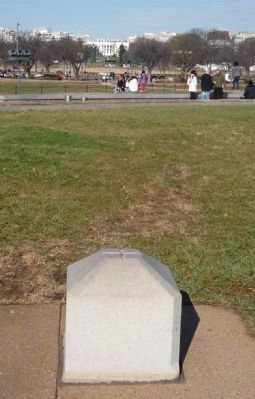
Original Federal
Boundary Stone
District of Columbia
Place 1791 - 92
Protected by
Patriots' Memorial Chapter
Daughters of the
American Revolution
1965 — — Map (db m154771) HM
Near Hyattstown Mill Road 0.2 miles east of Frederick Road ( Route 355), on the right when traveling east.
In operation since 1798, Hyattstown Mill was known for its “fine stone-ground white and yellow cornmeal." Destroyed by fire in 1918, the new mill was quickly rebuilt on the old foundation and remained a crucial local business until the mid-1930s. . . . — — Map (db m311909) HM
Near Martinsburg Road 0.2 miles north of Wasche Road, on the left when traveling north.
Prior to 1840, virtually all Montgomery County farms produced tobacco and corn primary crops of the era. In 1845, the emergence of guano fertilizer allowed farmers to introduce a new cash crop grain which provided feed for livestock.
The 1873 . . . — — Map (db m305866) HM
Near Glenallan Avenue east of Heurich Road, on the right when traveling east.
Hans Hanses, the M-NCPPC landscape designer responsible for designing the original gardens, was asked by several people what his design concept was for the gardens: "They were disappointed because there was no such [thing as a garden concept]. We . . . — — Map (db m114203) HM
Near Glenallan Avenue east of Heurich Road, on the right when traveling east.
The original concept for Brookside Gardens was to create an arboretum (a site that primarily focuses on trees and other woody plant materials); however after visiting several botanical gardens in New York plus a stop at Longwood Gardens in . . . — — Map (db m114208) HM
Near Glenallan Avenue east of Heurich Road, on the right when traveling east.
According to Carl Schoening, Chief of Horticulture for the Parks in 1969, "We're always kind of fashioned Brookside to be a miniature Longwood Gardens. To Some extent. Not a copycat, but along those lines."
If you've ever visited Longwood . . . — — Map (db m114206) HM
Near Glenallan Avenue east of Heurich Road, on the right when traveling east.
The first Trial Garden was a temporary display that tested new varieties of vegetables and annual plants for use in home landscapes. The permanent Trial Garden (pictured far right after completion) continues with this mission, but with more . . . — — Map (db m114204) HM
On Wharf Street 0.1 miles north of East Street, on the right when traveling east.
Welcome to Osprey Overlook Park, a recovered, natural setting that overlies an existing landfill and provides passive recreation opportunities and environmental education. Its use is governed by the Massachusetts Department of Environmental . . . — — Map (db m300027) HM
On Father Jacobbe Road at Lisbon Street, on the right when traveling east on Father Jacobbe Road.
Situated on the Clippership Wharf Harborwalk, 'Islands' is inspired by the historic transition of five natural islands (Noddles, Hogg, Apple, Bird and Governors Island) into a manufactured peninsula which is now known to us as East Boston. As . . . — — Map (db m215779) HM
On Lewis Street at East Pier Drive, on the right when traveling south on Lewis Street.
Much has changed along Boston's waterfront and in the harbor since this image was drawn in 1848. Wharves were constructed and mud flats filled, creating more land. Buildings went up; others were torn down.
What else is different? Which . . . — — Map (db m215790) HM
On River Street at Pine Street, on the right when traveling west on River Street.
Edwin S. Noble (1838-1922) designed
and built this house for his family in
1865. Noble, an expert accountant,
was associated with the Dexter Noble
Company, first as secretary-treasurer
and later as a full partner. The company
was involved in . . . — — Map (db m234603) HM
George Ackerman, as a UCHS student, noted this spot on the river as a possible location for a dam. He went on to become a civil engineer. Around 1919, rising coal costs forced the village to turn toward hydro and they sought out . . . — — Map (db m95654) HM
On East Central Avenue at Langlade Street, on the right when traveling west on East Central Avenue. Reported permanently removed.
Since the beginning of the 20th century, two main roads brought tourists to Northern Michigan.
These roads were the East and West Pikes and they converged in Mackinaw City.
In 1915 the East Pike became part of the Dixie Highway, a series of . . . — — Map (db m125535) HM
On Ashmun Street (Business Interstate 75) at Dawson Street, on the right when traveling south on Ashmun Street.
The man-made power canal that bisects the city of Sault Ste. Marie was constructed from 1898 to 1902. The flow of water from the upper St. Mary's river through the canal still generates electricity at the Edison Sault hydroelectric plant, also . . . — — Map (db m214229) HM
On East Grand Lake Road 0.9 miles north of County Road 638, on the right when traveling north.
Presque Isle Harbor is one of Lake Huron's safest harbors of refuge. Its name comes from this peninsula which, translating from the French, is "almost and island." Indians and Frenchmen portaged across the peninsula to avoid several miles of open . . . — — Map (db m40149) HM
With the metro Detrolit area growing, a new Lake Huron water intake and treatment plant was needed to serve both the Detroit and Flint areas. In 1968,
the Detroit Metro Water Department began a massive $125 million project of digging a water . . . — — Map (db m235474) HM
Near Fair Lane Drive 0.3 miles west of Evergreen Road.
Guests of the Fords came from all walks of life, and the Great Meadow that greeted them remains. Its designer, Jens Jensen, used thousands of native plantings to create this vista he labeled, "The Path of the Setting Sun-Summer." Every summer . . . — — Map (db m96937) HM
Nevers Dam, 1898.
Nevers Dam once linked Minnesota and Wisconsin from the point of land directly across the river to the place where you are standing. The dam was named after Charles Nevers, a Wisconsin farmer whose land was bought . . . — — Map (db m234287) HM
On 1st Avenue N. (U.S. 8) west of N. Lakes Trail, on the left when traveling west.
The Water Tower's Evolution
1848: Kichi Saga (Chisago) area is surveyed.
1880: Village of Lindström is platted on October 14.
1900: Voters approve a public waterworks system at a cost not to exceed $5,500. F.N. Benson to dig . . . — — Map (db m248011) HM
According to residents of Old Crow Wing, this centrally-located community well was a good place to get news in addition to water. — — Map (db m282920) HM
Near W. River Parkway, on the left when traveling south.
The Mississippi River 9-foot channel project was authorized by Congress in 1930. The project provides a continuous navigation channel for the commerce that enhances your quality of life.
Navigation on this waterway is made possible by 29 . . . — — Map (db m310912) HM
Near Godfrey Road 0.2 miles east of 46th Avenue South.
Big Water
The Mississippi River, paramount among North American rivers, along with its tributaries, forms the world's fifth largest drainage system in area – 1,244,000 square miles. The Indians called this river "Father of . . . — — Map (db m106852) HM
Near W. River Parkway, on the left when traveling south.
The miter gate operating machinery plays a vital role in the movement of goods and people on the river. The combined efforts of the parts you see in front of you control the opening and closing of the miter gates found at both ends of the river . . . — — Map (db m309128) HM
On Grant Street at Marquette Avenue / 1st Avenue, on the right when traveling east on Grant Street.
This church stands as the first Minneapolis Methodist Church founded west of the Mississippi River. It has been the site of several Annual Conference sessions and twice Methodist bishops have been consecrated at its altar. Having brought scores . . . — — Map (db m122510) HM
On 1st Street at East Williams Street, on the right when traveling north on 1st Street.
Francis Johnson of Darwin (1904-1989) was an ingenious wood carver, known for carving a one-piece pliers as small as an inch long that opened and closed without pins or other fasteners.
On larger pliers, Francis would carve another pliers from . . . — — Map (db m266389) HM
On Scenic Mississippi Route 333 0.1 miles north of Grenada Lake Visitor's Center, on the right when traveling north.
The Great Mississippi River Flood of 1927
affected an area of 27,000 square miles.
More than 130,000 homes were lost
and 700,000 people were displaced.
Congress took action, passing the Flood
Control Act of 1936. The U.S. Army
Corp of . . . — — Map (db m219775) HM
On Scenic Mississippi Route 315 north of Route 35.
Authorized by the Flood Control Act of
1936 and built by the U. S. Army Corps of
Engineers, Sardis Dam began operation
in October 1940. Located on the Little
Tallahatchie River, the dam contains
16,500,000 cubic yards of material and
controls . . . — — Map (db m267257) HM
Near Natchez Trace Parkway (at milepost 308.8), 1.2 miles north of Highway 30, on the left when traveling north.
The village site was occupied as early as 8000 B.C. by hunters who stayed only long enough to prepare their kill. From the time of Christ to 1000 A.D., migratory people of this area practiced limited agriculture.
The nearby fields and streams . . . — — Map (db m36061) HM
On South Mount Auburn Road south of Bloomfield Road.
Test your record-setting knowledge
Q1: How many hours did it take to fill the cup?
A: It took just under 3 hours to fill starting at 6am on August 20, 2017.
Q2: How many people worked to fill the cup?
A: Eight people worked to . . . — — Map (db m307393) HM
Near Dillard Mill Road (County Road 811) 1.6 miles south of State Highway 49, on the left when traveling south.
Dillard Mill is one of Missouri's best preserved examples of a water-powered
gristmill. The mill, which has been
restored to operational order, was
built around 1900 and continued
to grind grain until 1956.
[Captions]
Note: . . . — — Map (db m255301) HM
On North Boonville Avenue at East Central Street, on the left when traveling south on North Boonville Avenue.
These pillars stood at the front of the Greene County Courthouse on the public square, serving Greene County from April 1, 1861 until March 23, 1912 — — Map (db m311805) HM
On Center Street east of Main Street, on the left when traveling east.
Born in Hannibal, Lester Gaba competed
in a soap-sculpting (Scrappy Soaps)
competition for Proctor & Gamble at age
10. It was then that he decided he
wanted to be a soap-sculptor. In New
York in 1932, Lester designed Cynthia, a
lifelike . . . — — Map (db m302107) HM
On Rosebud Road 1.5 miles west of State Highway 314.
Be silent, close you eyes, and listen to the breeze as it rustles through the prairie grasses. To many, the whispering sounds make this a spiritual place. Hunans have defined this lans by its uses and the emotions it stimulates.
First . . . — — Map (db m189806) HM
Inside the Ryan Powerhouse, electricity is generated from Missouri River water as it drops 150 feet from the reservoir behind the dam. The water you see flowing from the bottom of the powerhouse has passed through the turbines and is returning to . . . — — Map (db m245998) HM
Although Lewis and Clark saw the waterfalls as an obstruction, a century later others viewed it as a way to meet the region's energy needs. The natural rapid drop in river elevation provided a ready-made source of water power to spin turbines and . . . — — Map (db m246037) HM
On Morony Dam Road near Sulphur Springs Road, on the left when traveling south.
(Three panels make up this marker; the center panel contains only hiking trail information) Land of Many Uses
When Lewis and Clark passed this way in 1805, they met no people but for thousands of years Indian lodges . . . — — Map (db m282901) HM
Near North Main Street (Business Interstate 90) near Warren Lane, on the left when traveling north.
The fields around you provide hay for the herd through the winter when grasses are dormant and covered with snow. With the transition from open range to modern ranching, growing hay became a necessity.
Loose hay stacks were the first method of . . . — — Map (db m210114) HM
Near North Main Street (Business Interstate 90) near Warren Street, on the left when traveling north.
The Homestead Act of 1862 and the Desert Land Act of 1877 allowed private land ownership. Homesteaders had to build fences to keep out the open range cattle. Their work became easier when the 1874 Glidden patent lead to the large-scale production of . . . — — Map (db m210112) HM
Near Continental Drive near Madison Street, on the left when traveling south.
Placer Mining
1864- 1875
Early pioneers used placer mining, or gold panning, which relied on water to separate waste rock from the gold (placer ore). Gold is heavier and sinks to the bottom. Placer mining tools generally include the . . . — — Map (db m205897) HM
3535 entries matched your criteria. Entries 101 through 200 are listed above. ⊲ Previous 100 — Next 100 ⊳