On Poplar Street at 2nd Street, on the right when traveling east on Poplar Street.
This building constructed in 1918-19 cost a total of $75,000 including the site, furnishings, and fixtures. Listed on the National Register of Historic Places, it served as the U.S. Post Office for Rogers for over four decades. These 1918 . . . — — Map (db m90744) HM
On South 1st Street north of West Elm Street, on the right when traveling north.
To commemorate the Centennial passage, through Benton County of the First Westbound Stage coach on the Butterfield Overland Mail Route from St. Louis to San Francisco. Callahan's Tavern, the site of which is about a half a mile northeast of this . . . — — Map (db m216324) HM
On East Rush Avenue at North Main Street (Business U.S. 65), on the left when traveling east on East Rush Avenue.
It was completed in 1903 and served as the Post Office from 1906 - 1965. The three story (plus basement) building was constructed at an original cost of $78,000 with a floor space in excess of 20,000 sq ft. It was constructed of hard-burned, dark . . . — — Map (db m141866) HM
On South 3rd Street at Main Street, on the left when traveling south on South 3rd Street.
In this small log building Albert Pike noted lawyer, poet and mason taught school in 1832. He later went to Little Rock to become editor of the Advocate. — — Map (db m96857) HM
On North Currie Street east of Currie Avenue, on the left when traveling east.
Woolfolk is author of The History of Marion and History of Crittenden County, an award-winning newspaper editor, graduated from Memphis State Law School in 1985 at the age of 68, entered into private practice, and served as Marion . . . — — Map (db m116783) HM
On Military Road east of Cypress Drive, on the right when traveling east.
Designed and built by Major Moore for Thomas Koser, the building was completed December of 1911. The building, which is constructed of native hardwoods, brick and concrete, had pressed tin ceilings and hardwood floors. The hotel had its own water . . . — — Map (db m116726) HM
On East Broadway Boulevard (U.S. 70) at South 2nd Street, on the right when traveling east on East Broadway Boulevard.
The inaugural broadcast of West Memphis' KWEM radio station on February 23, 1947, set the stage for what would become one of the pioneering platforms for Delta blues and the beginnings of the rock 'n' roll sound.
Here at 231 Broadway Boulevard in . . . — — Map (db m221358) HM
Near Harkrider Street (Business U.S. 65) at Markham Street, on the right when traveling south.
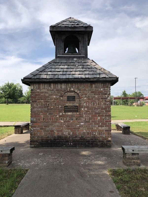
In 1883 a bell was installed in the tower of the new three-story brick building at Altus, Arkansas, which housed Central Collegiate Institute (later Hendrix College). It is believed this is the bell which hung in the tower until the building burned . . . — — Map (db m237133) HM
Near U.S. 63 at Main Street (State Route 9), on the right when traveling north.
In 1919, George D. Hay, a young newspaper reporter for the Memphis Commercial Appeal, visited Mammoth Spring while on assignment. Before boarding the train back to the city, Hay was invited to a traditional Ozark musical and marveled at the . . . — — Map (db m192093) HM
On West Division Street at South Main Street, on the right when traveling west on West Division Street.
The last bag of mail hung on this pole was October 14, 1967 at Ward, Arkansas. This was also the final day of operation for the Railway Post Office in the state. — — Map (db m161919) HM
On East Division Street at South Main Street, on the right when traveling west on East Division Street.
This two man inspection car was built in 1948 by Fairmont Railway Motors. Signalmen especially, relied on this motor car for transportation as they inspected signals, automatic switches and crossing gates.
Known for its light weight and easy . . . — — Map (db m161915) HM
On Franklin Street east of Arkansas Highway 278, on the left when traveling west.
The Washington Post Office is the oldest continuous postal facility in Arkansas, having been established as Hempstead Courthouse Post Office, Arkansas Territory, February 23, 1820. This building provided by the Pioneer Washington Foundation -- . . . — — Map (db m244819) HM
On Broad Street at East Main Street, on the right when traveling south on Broad Street.
Authorized 1857. Manufactured
1858. First used 1859. Ringing out
from Independence County's
second courthouse, the first on
this site, this bell summoned
citizens to meetings, warned
them of danger, and called them
to celebrate. Today it . . . — — Map (db m221140) HM
On Arkansas Route 932 at Main Street (Arkansas Route 14), on the left when traveling north on State Route 932.
When the white man came into the White River
valley, Oil Trough Bottom was covered with a
dense canebrake inhabited by bear. Early
hunters rendered the bear oil and stored it
in troughs made from hollowed out tree trunks.
Use of these troughs . . . — — Map (db m221215) HM
On West Main Street (U.S. 64) at Central Street, on the right when traveling east on West Main Street.
This bell was in use at the school at Lone Pine 1921-1953. The bricks in this monument were made on the site and used to build the Hagarville Academy in 1918. — — Map (db m225423) HM
On County Road 6035, 0.2 miles east of County Highway 637, on the left when traveling east.
Across Rush Creek, in front of you, are the remains of houses and shops once owned by the Morning Star. Many families lived there over the years, some until the late 1960s. The building nearest you was the Taylor-Medley Store-started by Bill . . . — — Map (db m161937) HM
On North Ash Street at East Johnson Avenue, on the right when traveling south on North Ash Street.
Built in 1911 by a local attorney, R.C. Rose, as Osceola's first telephone office, the building features two louver-covered windows, a cornice dividing the two floors and two square pilasters with corbelled brick separating the upper 8-over-8 . . . — — Map (db m36707) HM
On North Poplar Avenue at West Hale Avenue, on the right when traveling north on North Poplar Avenue.
This 1901 office was the first building in "New Town," having been used continuously as a newspaper office since that time and remains the oldest and tallest commercial building in the city. The "Osceola Times," reporting on life along the Cotton . . . — — Map (db m36408) HM
On 2nd Street at East Ash Street, on the left when traveling north on 2nd Street.
Potts Inn John Kirkbride Potts (1803-1879) was born in Pennsylvania and moved to Arkansas in the 1820s. In 1828 he settled by Galla Creek, eventually acquiring 650 acres of land. Potts went to California in the Gold Rush of 1849: he failed to . . . — — Map (db m225451) HM
On East Ash Street at 2nd Street, on the right when traveling east on East Ash Street.
Historic stage coach tavern erected by Kirkbride Potts with slave labor. This tavern was a station on the Butterfield-Overland Mail. It was operated as a tavern both before and after the existence of the Butterfield-Overland Mail contract. It has . . . — — Map (db m225477) HM
On West Main Street (U.S. 64) at South Denver Avenue, on the right when traveling east on West Main Street.
In 1854, Mr. J. L. Shinn established a business at this location in what was then called a cactus prairie. By 1870, other businesses had been established and residence had been built so the community was incorporated and was named Russellville, . . . — — Map (db m225435) HM
On Radio Drive at U.S. 62, on the left when traveling west on Radio Drive.
In the mid 1950s Elvis Presley's career was just beginning to take off. Elvis had made at least one record at Sun Studio in Memphis when he and his then manager made a stop at this location to request that his record be played on KPOC. He was . . . — — Map (db m207800) HM
Founded in 1876 by W.A. Webber as The Saline County Digest, this was the first newspaper and is the oldest continuously operated business in Saline County. The name was changed to The Review in 1882 and to The Courier in 1883. The original office . . . — — Map (db m104055) HM
On Rogers Avenue at South 4th Street, on the right when traveling south on Rogers Avenue.
Commemorating arrival of the first Butterfield Overland mail coach, St. Louis to San Francisco, arrived in Fort Smith at John Rogers City Hotel, North 2nd and A Streets, 2:00 a.m. September 19, 1858. — — Map (db m236790) HM
On South Izard Street south of Court Avenue, on the left when traveling south.
This bell rang from the bell tower of the magnificent courthouse that graced this site for seventy-nine years before the present structure was built in 1976. The former courthouse was built in 1897 by Judge John S.R. Cowan of Hughes at a cost of . . . — — Map (db m172208) HM WM
On Mount Holly Highway (Arkansas Route 160) 0.4 miles east of Stephens Highway (Arkansas Route 57), on the right when traveling east.
Mount Holly Cemetery is the final resting place of 15 Confederate soldiers, including Asa S. Morgan, who in 1861 recruited the El Dorado Sentinels, which became Co. A, 1st Arkansas Infantry. Morgan later served as colonel of the 26th Arkansas . . . — — Map (db m121172) HM
On North Campus Walk north of West Dickson Street, on the left when traveling west.
The most widely implemented automated mail sorting equipment in the world – the Wide Area Bar Code Reader – was developed by the University of Arkansas' College of Engineering. A $50,000 grant from the U.S. Postal Service (USPS) to Professors Dwight . . . — — Map (db m224261) HM
On East Buchanan Street (Business U.S. 62) at North Neal Street, on the right when traveling west on East Buchanan Street.
On this site stood the former home of Dr. James W.
Webb (1878 1947) and Mrs. Joy Nelson Webb
(1891-1976). Dr. Webb also owned and operated a
dentist office on this property. Mrs. Webb published
and edited the weekly Prairie Grove . . . — — Map (db m225087) HM
On Old Wire Road (State Highway 265) south of Dodd Avenue, on the right when traveling north.
Here on this, the Old Wire Road, was located Fitzgerald's Station on the Butterfield Overland mail route from St. Louis to San Francisco. First trip 1858. Last 1861. Longest and best conducted mail route in the world. 2795 miles. Service twice . . . — — Map (db m59950) HM
On Santa Clara Avenue at Park Street, on the right when traveling north on Santa Clara Avenue.
NEWSPAPERS were the main source of
public information before the introduction
of radio and television. The Bay Area was
home to several daily newspapers and the
larger publishers produced as many as five
editions released throughout the day. . . . — — Map (db m145341) HM
On Delaware Street east of 6th Street, on the right when traveling east.
This building, thought to be Berkeley’s oldest remaining structure, originally stood on the Contra Costa Road, now San Pablo Avenue. Built by Captain William J. Bowen when the area was sparsely populated, it served as an inn, saloon, grocery . . . — — Map (db m53831) HM
Along the ridge behind this panel lies a 52-acre parcel of historical significance. This farmstead known as “Ukraina” was the home of Ukrainian patriot, writer, and publisher Father Agapius Honcharenko. He and his wife Albina lived here . . . — — Map (db m26499) HM
“Ukraina” is the site of the farm and burial place of the Ukrainian patriot and exiled orthodox priest Agapius Honcharenko (1832-1916) and his wife Albina. Honcharenko was the first nationally conscious Ukrainian to arrive in the United States. He . . . — — Map (db m146447) HM
On Nevada Street west of Bernal Avenue, on the left when traveling west.
This antique fire bell was used to notify Livermore Volunteer Firefighters of a fire in their community from 1875 until replaced by an electric siren in 1919. — — Map (db m204228) HM
On Nevada Street, on the left when traveling west.
This antique fire bell was used to notify Pleasanton Volunteer Firefighters of a fire in their community from 1908 until replaced by an electric siren in 1919. — — Map (db m204231) HM
On Main Street at Division Street, on the left when traveling north on Main Street.
Originally installed by the Women's Improvement Club in 1932, the Pleasanton Sign has become a familiar landmark and prominent symbol of the community. In 2005, the sign underwent complete restoration, and was rededicated by the City Council on . . . — — Map (db m193940) HM
On Carson Pass Scenic Byway (State Highway 88), on the right when traveling east.
“…there ought to be a shaft raised to Snow-Shoe Thompson: Not of marble; Not carved and not planted in the valley, but a rough shaft of basalt or of granite, massive and tall, with top ending roughly as if broken short, to represent a life . . . — — Map (db m12028) HM
On Diamond Valley Road, 3 miles east of California Highway 89, on the right when traveling west.
This marks the home of John Albert Thompson (Snowshoe Thompson) great pioneer of the Sierras and hero of the mountains, who for twenty winters carried the mail over the deep snow of the mountains on his long skies: Giving help to those in need along . . . — — Map (db m21302) HM
On Diamond Valley Road, 3 miles east of California Highway 89, on the right when traveling west.
John A. “Snowshoe” Thompson (1827-1876) Native of Norway who carried mail across the Sierra Nevada on skis, assisting the needful for twenty years, dwelt and died on this site.
Dedicated on June 30, 1990
Native Sons of the Golden . . . — — Map (db m21301) HM
On Old Pony Express Way (California Route 88) east of California Route 89, on the right when traveling east.
During the initial five weeks of its operation in 1860, an important remount station of the famous Pony Express was located a few feet from here at Cary’s Barn.
This monument erected by the Historical Society of Alpine County.
National . . . — — Map (db m143520) HM
On Old Pony Express Way (California Route 88) east of California Route 89, on the left when traveling east.
Historic Woodfords Station, the Eastern Sierra gateway to the goldfields of California, way station of the famed Pony Express, and entrance to Carson Pass on the Emigrant Trail to the Sacramento Valley. Beginning in 1849 with the building of the . . . — — Map (db m195369) HM
On State Highway 88 east of Wicklow Way, on the right when traveling east.
This newspaper was started in Volcano October 27, 1855. It was moved to Jackson in April, 1857. The Amador Ledger is the fourth oldest weekly newspaper in California and the oldest in Amador County. This building became the new home of the Amador . . . — — Map (db m44139) HM
On South Main Street (State Highway 49), on the right when traveling north.
Fashioned as either small ornaments or large enough to be heard for miles, bells have long been a part of human history and culture. First appearing around 2000 B.C. as simple percussion instruments, they continue to celebrate special events to this . . . — — Map (db m101587) HM
On Main Street, on the right when traveling north.
Present site of one of the last family-founded and-still-operated-by-that-family phone companies in America. Founded by Jim Tower, who strung his first telephone wires in 1895 tacked along posts of barb wire fences, earning himself the colorful . . . — — Map (db m57982) HM
Near Danville Boulevard near Stone Valley Road, on the right when traveling south.
John M. & Mary Ann Smith Jones, lived at this location from 1851 - 1866. They came out west in a prairie schooner. Here John opened the only post office between Martinez and Mission San Jose on May 18, 1852. Mary Ann was his deputy while her . . . — — Map (db m93991) HM
On Center Street west of Marsh Creek Road, on the right when traveling east.
The Clayton Post Office, established on October 4, 1861, is one of the oldest post offices in continuous operation in California. Ensuring its continuation in Clayton was one reason for incorporating the city in 1964.
During the past 140 . . . — — Map (db m24534) HM
Near Povda Road at San Ramon Valley Boulevard, on the right when traveling south.
This Victorian style house was built around 1885 and was purchased by Adolphus Podva and Mary Alma McPherson for ten gold coins. In 1911, one of their three sons, Roger and his wife Ruby May Oswill, purchased it and lived there until 1977. Ruby May . . . — — Map (db m202118) HM
On San Pablo Dam Road near Pitt Way, on the left when traveling east.
El Sobrante's first free-standing post office opened in this building in 1957, marking an important milestone in the town's development. The post office was previously located in the adjacent Lee's Variety Store (the Elks Lodge as of 2014) and . . . — — Map (db m94308) HM
In 1860-1861 Pony Express riders stopped in Lafayette 19 times to change horses en route to San Francisco from St. Joseph, Missouri
Lafayette Historical Society
1992 — — Map (db m24461) HM
On Mt. Diablo Boulevard at Morago Road, on the right when traveling east on Mt. Diablo Boulevard.
Dedicated April 23, 1998
Lafayette House
Added Station
By
Diablo Foods
Better Homes Realty - Lafayette
Diamond K. Supply, Ltd.
Lafayette Chamber of Commerce
Lafayette Historical Society
Pony Express Trail Association
{reverse . . . — — Map (db m24916) HM
On Ferry Street at Ward Street, on the left when traveling north on Ferry Street.
Built after the Fire of 1904 that consumed the entire block Occupied in 1881 by Contra Costa Telephone Company founded in 1881 by J. Borland which was sold to Pacific Bell Telephone Company in 1892 with R. Borland as superintendent for 40 years . . . — — Map (db m53919) HM
On Main Street at Ferry Street, on the right when traveling east on Main Street.
Dedicated April 23, 2000
Morgan House
Pony Express Route
Apr. 23, 1860 - Sep. 8, 1861
Home Station
Apr. 16, 1869 - Sep.8, 1861
By
James Stretesky
Supervisor Gayle B. Uilkema
Martinez Area Chamber of Commerce
Pony Express Trail . . . — — Map (db m24369) HM
On Ferry Street near Marina Vista Avenue, on the left when traveling north.
Dedicated April 23, 2005
Martinez
By James Stretestky · Julian M. Frazer · Martinez Historical Society · Mayor Rob & Carole Schroder · Supervisor Gayle B. Uilkema · Vice Mayor Mark & Dianne Ross · Tesoro's Golden Eagle Refinery · . . . — — Map (db m19224) HM
Near Camino Pablo west of Brookwood Road, on the right when traveling north.
A nearby plaque
commemorates the
passage in 1860-1861
of Pony Express riders
from Sacramento to
the San Francisco
terminus. They usually
rode river steamers,
but 20 times the Pony
Express took an
overland route as the
steamers did not . . . — — Map (db m142217) HM
Pony Express Trail
This plaque commemorates the passage in 1860 and 1861 of the Pony Express riders from Sacramento to San Francisco through what is now Orinda.
Sponsored by the City of Orinda's Historical Landmark Committee and the Pony . . . — — Map (db m29913) HM
On Railroad Avenue north of East 6th Street, on the right when traveling north.
Built in 1923, this brick building was the home of the Coast Counties Gas and Electric Company which provided utilities to the City of Pittsburgh. The company closed its office in the 1950s and the building became a newspaper publishing and . . . — — Map (db m37423) HM
Constructed in 1873-74, East Brothers Light Station is the older of only two remaining light stations of San Francisco Bay that have remained substantially unchanged. The original 5th order classical (Fresnel) lens was replaced with the present . . . — — Map (db m164491) HM
When James Pomeroy Howe died in
1970, at the age of 91, he left behind
not only his estate and its history, but
also a legacy of intriguing stories of his
adventures here and abroad.
While growing up in Kansas Jim Howe longingly
dreamed of . . . — — Map (db m153429) HM
On North Main Street near Cypress Street, on the left when traveling south.
In the early years, Walnut Creek residents picked up their mail from one of the local merchants on Main Street, who served as postmaster. This brick building served as Walnut Creek's first post office, beginning in 1928. A newer post office opened . . . — — Map (db m93826) HM
On Cypress Street at North Main Street, on the right when traveling east on Cypress Street.
The 400-seat Ramona, Walnut Creek's first cinema, opened in 1920 as a silent-movie house. The theater sat on Main Street, next to the Contra Costa Courier newspaper and where Cypress Street now connects to Broadway. It was owned by Theodore . . . — — Map (db m93828) HM
Near Summit Road, 11 miles north of Blackhawk Road, on the right when traveling north.
Mount Diablo has always been a guide and landmark to people far bellow, and so it became a natural location for many radio and transmission towers as well.
As early as 1928, the Standard Oil Company and U.S. Dept. of Commerce jointly . . . — — Map (db m103092) HM
The Battery Point Lighthouse is one of the first lighthouses on the California Coast.
Rugged mountains and unbridged rivers meant coastal travel was essential for the economic survival of this region.
In 1855 Congress appropriated $15,000 for . . . — — Map (db m101692) HM
On Coloma Road (California Route 49) south of Mt Murphy Road, on the right when traveling south.
Coloma’s first post office opened in 1849 when, against his wishes, John T. Little was appointed postmaster. The post office, first designated as “Culloma, California Territory,” was changed to “Coloma” in January 1851. This tiny building . . . — — Map (db m215207) HM
On Coloma Road (California Route 49) at Mt Murphy Road, on the right when traveling north on Coloma Road.
Patrick Obein Murphy brought this cannon from Ft. Ross to his namesake Mt. Murphy located behind this site. It’s been said that he fired it to announce the arrival of the mail. — — Map (db m215523) HM
On Mt Murphy Road at Levee Trail, on the left when traveling east on Mt Murphy Road.
This area held a number of important homes and stores during the gold rush. The first large building in Coloma was built here in 1849 by John T. Little. It contained a store, hotel, restaurant and post office. Little also operated a ferry to cross . . . — — Map (db m215742) HM
On State Highway 49, on the left when traveling south. Reported permanently removed.
Most of Coloma's buildings were wooden, but some were were made of brick or stone to resist fire. This one, known as "Bells Brick Store," was a general merchandise store that also sold feed and grain. The U.S. Post Office was located in this . . . — — Map (db m12207) HM
On Coloma Road (California Route 49 at milepost 2) south of Brewery Street, on the right when traveling north.
Robert Bell arrived in 1850 and built a wooden store. When this burned down he erected a brick building in the same location in 1853. It was known as “Bell’s Brick Store,” a general merchandise store that also sold feed and grain. The U.S. Post . . . — — Map (db m215357) HM
On Pleasant Valley Road, on the right when traveling east.
Trading post, emigrant stop, and mining camp of the 1850’s. This became one of the remount stations of the Central Overland Pony Express. Here at the Nevada House on April 13, 1860, pony rider William (Sam) Hamilton changed horses while carrying . . . — — Map (db m11571) HM
On Lincoln Highway (U.S. 50) west of Apache Avenue, on the left when traveling west.
Send me men to match my mountains.
These are words a great poet said speaking for the brave young nation that needed strong and brave men’s aid.
In memory of
John (Snowshoe) Thompson
who, for twenty successive winters, 1856-1876, . . . — — Map (db m434) HM
On Lincoln Highway (U.S. 50) west of Apache Avenue, on the left when traveling west.
>br>(back) The Hawley Grade from April 3, 1860 to November 17, 1860 was used by the Pony Express. On November 18, 1860 the new toll road down Johnson Pass (Echo Summit), today’s Old Meyers Grade, was opened to horse traffic and was now used . . . — — Map (db m435) HM
On US Highway 50 (U.S. 50) west of Pioneer Trail, on the left when traveling west.
This was the site of the most eastern remount station of the Central Overland Pony Express in California. Established as a trading post in 1851 by Martin Smith, it became a popular hostelry and stage-stop operated by Ephraim “Yank” Clement on the . . . — — Map (db m433) HM
On Main Street at Sacramento Street, on the right when traveling east on Main Street.
This building was used as a
post office from 1854 through
1858. Famous Norwegian skier and
mailman Snowshoe Thompson
picked up his first mail here in
1856. His courage and
perseverance conquered the
impassable winter Sierra Nevada
mountains . . . — — Map (db m193324) HM
On Main Street at Stage Coach Alley, on the right when traveling west on Main Street.
Fisher’s Oasis Coffee House and Wadsworth’s Chicago Dining Saloon occupied this site from 1851- 1855. In 1853 F.A. Bee, founder of the Placerville Herald, printed his short-lived newspaper here. Early pioneer doctors, Harvey and Sholer and . . . — — Map (db m65253) HM
On Sacramento Street at Main Street, on the right when traveling north on Sacramento Street.
This statue commemorates the life
and career of Norwegian American pioneer
and skier, John A. Snowshoe Thompson, who
by his courage and perseverance conquered
the impassable winter Sierra Nevada
mountains to carry mail, medicine and
supplies . . . — — Map (db m193400) HM
On Main Street at Sacramento Street, on the right when traveling east on Main Street.
A Viking Son of Norway who fulfilled California’s motto:
“Bring Me Men To Match My Mountains”
For twenty winters from 1858 to 1878 he was the lifeline between Utah Territory across the Sierras, and the new state of California. . . . — — Map (db m12750) HM
On Pony Express Trail east of Exit 57 (U.S. 50), on the right when traveling east.
California’s only Home Station where riders changed on the Pony Express trail. Here, at 8:01 A.M. on April 4, 1860, Sam Hamilton, first eastbound rider, was relieved by Warren Upson who carried the initial mail over the then storm swept Sierras.
. . . — — Map (db m613) HM
On Pony Express Trail east of Exit 57 (U.S. 50), on the right when traveling east.
This was the site of Sportsman’s Hall, also known as Twelve-Mile House. The hotel operated in the late 1850’s and 1860’s by John and James Blair, a stopping place for stages and teams of the comstock. It became a relay station of the Central . . . — — Map (db m609) HM
On Pony Express Trail (Lincoln Highway) at Forebay Road, on the right when traveling east on Pony Express Trail (Lincoln Highway). Reported missing.
The Pony Express originated in 1860, when our nation was divided and civil war threatened. Communication between California and Washington DC took months. Although the Pony Express existed little more than 18 months, it played a major role in the . . . — — Map (db m94642) HM
On Durock Road south of U.S. 50, on the right when traveling west.
Dedicated July 1, 2000
Du Roc House
Added Station
July 1, 1861 – Nov. 20, 1861
by
PW Pipe
James Stretesky
Norman & Ann Root
County of El Dorado
American Suzuki Motor Corporation
Pony Express Trail . . . — — Map (db m50321) HM
Built for Captain H.H. Buhne; Humboldt County Bank, other businesses, residences, public hall, rooftop signal service station.
This program made possible through a partnership with property owners Kelly and Kala Martin, Eureka Main Street, and . . . — — Map (db m61275) HM
On F Street at 6th Street, on the right when traveling south on F Street.
On Nov. 10, 1908, a deed from George and Edith Connick to Sunset Telephone and Telegraph Company, Block 56, Parcel 5, corner of 6th and “F” Streets was recorded. When Pacific Telephone and Telegraph took over the Sunset Telephone and Telegraph . . . — — Map (db m233368) HM
On 2nd Street east of G Street, on the right when traveling east.
This was the first building expressly constructed for the Eureka Post
Office Postmaster Frederick Aze, (served as Eureka postmaster for 17
years.) motivated by cramped and ill suited facilities at 612
Second St. had this building constructed at . . . — — Map (db m135482) HM
On 5th Street near Van Ness Avenue, on the left when traveling south.
The 780 prisms and fresnel lenses in this replica of the original Cape Mendocino Light House were hand ground in France, shipped around Cape Horn and originally placed in operation at Cape Mendocino in 1868. The entire mechanical gear and prisms . . . — — Map (db m189002) HM
On Ocean Avenue at Francis Street on Ocean Avenue.
The Victorian Inn was built in 1890 with completion in 1891, and known as the Russ Building. The structure was originally built to house the Ferndale Bank with the Ferndale Enterprise Newspaper following. There were 33 rooms on the second floor; . . . — — Map (db m65289) HM
A native of Plunkett, Saskatchewan, Canada. Graduated from Stanford University with a degree in Civil Engineering, began work with the Division of Highways in 1936. He worked in many positions and locations throughout his career, becoming State . . . — — Map (db m1509) HM
On Lower Pacific Drive, on the left when traveling west.
Lit Dec. 1, 1868, the light from its first order Fresnel lens swept 30 miles to sea. Decommissioned in 1951, the structure slowly began to inch toward the 422’ cliff. The light was dismantled in 1998 and moved to Point Delgada, Shelter Cove by . . . — — Map (db m1093) HM
The Trinidad Memorial Lighthouse is one of the most iconic landmarks on the North Coast and a beloved, historical symbol of the Trinidad community. The structure was built in 1949 as a replica of the original 1871 Trinidad Lighthouse, which . . . — — Map (db m139525) HM
On North 8th Street at Broadway Street, on the right when traveling north on North 8th Street.
The Imperial Valley Press was established in 1901 with the aid of W.F. Holt in the town of Imperial and was known as the Imperial Press. Mr. Holt moved the paper to the new city of El Centro in 1906 and changed the name to the Imperial Valley Press. . . . — — Map (db m105982) HM
4130 entries matched your criteria. Entries 101 through 200 are listed above. ⊲ Previous 100 — Next 100 ⊳