By Mark Hilton, January 14, 2017
Bay Minette, Alabama Marker (side 2)
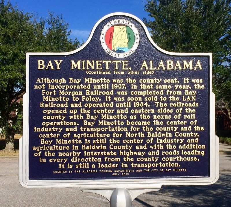
| On West 2nd Street east of McMillan Avenue, on the right when traveling east. |
| On North Hickory Street at Municipal Park Drive, on the right when traveling south on North Hickory Street. |
| On County Road 32, 0.2 miles west of Sherman Road, on the right when traveling west. |
| On Blue Springs Street, on the right when traveling west. |
| On East Broad Street east of North Livingston Avenue, in the median. |
| Near Blocton Bypass (County Road 24) west of Griffin Town Road, on the right when traveling west. |
| On 2nd Street South, 0.2 miles south of Alabama Highway 75, on the right when traveling south. |
| On Ingram Avenue East at 2nd Street South, on the right when traveling east on Ingram Avenue East. |
| On East Railroad Avenue at Jones Street, on the right when traveling north on East Railroad Avenue. |
| On West Commerce Street (Alabama Route 10) at Bolling Street, on the left when traveling west on West Commerce Street. |
| On Airport Road, 0.1 miles south of Old Stage Road, on the right when traveling south. |
| On Walnut Avenue at 12th Street, on the right when traveling south on Walnut Avenue. |
| On West 4th Street east of Spruce Avenue, on the right when traveling east. |
| Near Mountain Street Northwest west of Woodward Avenue Northwest. |
| Near Mountain Street Northwest west of Woodward Avenue Northwest. |
| On Main Street at East Oak Street, on the right when traveling north on Main Street. |
| On North Center Avenue at Front Street East on North Center Avenue. |
| On Shinbone Valley Road (County Road 127) 2 miles south of Alabama/Georgia State Line when traveling south. |
| On Canyon Drive (Alabama Route 35) at Main Street (Alabama Route 68), on the right when traveling south on Canyon Drive. |
| On Alabama Route 273 near County Road 81, on the left when traveling north. |
| On County Road 15 at State Route 35, on the right when traveling north on County Road 15. |
| On Industrial Boulevard (Alabama Route 68) at Lokey Street on Industrial Boulevard. |
| On Blue Pond Road (State Highway 273) at County Road 365, on the right when traveling south on Blue Pond Road. |
| On County Route 29 at County Route 45, on the right when traveling north on County Route 29. |
| On County Road 29 at County Road 27, on the left when traveling east on County Road 29. |
| On County Road 63, 0.6 miles north of State Route 143, on the right when traveling north. |
| On Wilson Avenue at Nicol Avenue, on the left when traveling west on Wilson Avenue. |
| On Main Street at Rickwood Drive, on the left when traveling east on Main Street. |
| On Railroad Street, 0 miles south of West College Street, on the right when traveling south. |
| On N. Montgomery Avenue near W 3rd St and N. Montgomery Avenue. |
| On South Main Street at 4th Street, on the right when traveling south on South Main Street. |
| On South Main Street at West 6th Street, on the right when traveling south on South Main Street. |
| On West 5th Street at South Water Street, on the right when traveling west on West 5th Street. |
| On Depot Square north of Mill Street, on the right when traveling south. |
| On Alabama Route 41, 0.1 miles south of U.S. 84, on the right when traveling north. |
| On South Main Street (U.S. 331/84) north of Cummings Avenue (U.S. 331/84), on the left when traveling north. |
| On U.S. 84 at Red Level Road (County Road 107), on the right when traveling west on U.S. 84. |
| On Lee Street (State Road 10) at North Watts Avenue, on the right when traveling west on Lee Street. |
| On Arnold Street, on the right when traveling east. |
| On 4th Street Southwest at 5th Avenue Southwest, on the right when traveling east on 4th Street Southwest. |
| On Main Street Northeast (U.S. 31) south of Arkadelphia Road (State Route 91), on the right when traveling south. |
| On East Broad Street (Alabama Route 27) at Depot Avenue, on the right when traveling west on East Broad Street. |
| Near Cahaba Road at Capitol Street, on the right when traveling north. |
| Near Capitol Avenue near Vine Street. |
| On Vine Street, on the right when traveling north. Reported permanently removed. |
| On Vine Street north of Capitol Avenue, on the right when traveling north. |
| On 1st Street North, on the left when traveling west. Reported permanently removed. |
| On Capitol Avenue, on the right when traveling east. |
| On Sylvan Street at Water Avenue, on the right when traveling north on Sylvan Street. |
| On 5th Street south of Gault Avenue North (U.S. 11), on the right when traveling north. |
| On North Broad Street at West Coosa Street, on the right when traveling north on North Broad Street. |
| On U.S. 31 at Baker Street, on the right when traveling east on U.S. 31. |
| On East Louisiana Avenue east of North Pensacola Avenue, on the right when traveling east. |
| On East Nashville Avenue (U.S. 31) 0.1 miles west of Presley Street, on the right when traveling west. |
| On St Joseph Ave (U.S. 31) at Deer Street, on the right when traveling north on St Joseph Ave. |
| On Sidney E Manning Blvd (U.S. 29) at Houston Street, on the right when traveling north on Sidney E Manning Blvd. |
| On Manassas Street at Misella Street on Manassas Street. |
| On Canterbury Street at Richmond Avenue, on the right when traveling north on Canterbury Street. |
| On U.S. 31 at Old US Highway 31, on the right when traveling north on U.S. 31. |
| On 5th Avenue Northeast (U.S. 431) at Cleveland Avenue, on the right when traveling south on 5th Avenue Northeast. |
| On Depot Street just north of Front Street, on the right when traveling north. |
| On 2nd Street West at 4th Avenue South (Alabama Route 24), on the right when traveling north on 2nd Street West. |
| On County Route 23 north of Alabama Route 19, on the right when traveling north. |
| On Alabama Route 10, on the right when traveling east. |
| On North Broad Street (Alabama Route 173) 0.1 miles north of North Railroad Street (County Route 7), on the right when traveling north. |
| On 3rd Avenue at Midland Street, on the right when traveling north on 3rd Avenue. |
| On Depot Street at North St Andrews Street, on the right when traveling west on Depot Street. |
| Near Alabama Route 605 at Hosea Road, on the right when traveling north. |
| On Alabama Route 227 at Busbey Ave, on the right when traveling north on State Route 227. |
| On W Maple Avenue near N Houston Street. |
| On East Maple Avenue at North Houston Street, on the right when traveling east on East Maple Avenue. |
| On West Main Street (State Highway 117), on the left when traveling south. |
| Near Valley View Drive west of Richard Arrington Jr Boulevard South. |
| Near Richard Arrington Jr. Boulevard South, 0.4 miles south of 16th Avenue South, on the right when traveling south. |
| Near Richard Arrington Jr Boulevard, 0.4 miles south of 16th Avenue South, on the right when traveling south. |
| On 1st Avenue North (U.S. 11), on the right when traveling north. |
| Near 1st Avenue North (U.S. 11) south of 83rd Street North. |
| On 20th Street South at 11th Avenue South, on the right when traveling north on 20th Street South. |
| On 32nd Street North, on the left when traveling north. |
| On 32nd Street North south of 29th Avenue North, on the left when traveling south. |
| Near Valley View Drive west of Richard Arrington Jr Boulevard South. |
| On Morris Avenue, on the right when traveling east on Morris Avenue. |
| On 27th Street North at 31st Avenue North, on the left when traveling north on 27th Street North. |
| Near 1st Avenue North (U.S. 11) near 32nd Street North. |
| On 29th Street South at Rhodes Circle South, on the left when traveling north on 29th Street South. |
| On 20th Street (Alabama Route 269) at Ensley/5 Points W Avenue, on the right when traveling west on 20th Street. Reported missing. |
| On Oxmoor Road at Broadway Street, on the right when traveling west on Oxmoor Road. |
| On South Shades Crest Road, 0.8 miles south of Bessemer Cut Off Road (State Highway 150), on the right when traveling south. |
| On Ross Bridge Parkway, 2.7 miles north of State Highway 150, on the left when traveling north. |
| On Thornton Avenue NE, on the right when traveling east. |
| On Thornton Avenue, on the right. |
| On Port Birmingham Rd (State Highway 269) at Finland Road, on the right when traveling west on Port Birmingham Rd. |
| On Parkway Drive at Lake Street, on the right on Parkway Drive. |
| On Alabama Route 17 at East Front Street, on the right when traveling north on State Route 17. |
| On Huntsville Road near S Royal Avenue and Georgia Avenue. |
| On Mitcham Avenue at North Gay Street, on the right when traveling east on Mitcham Avenue. |
8785 entries matched your criteria. The first 100 are listed above.
Next 100 ⊳