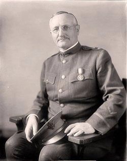
This is the site of the family home of Gadsden native General William Luther Sibert who played a major role in the construction of the Panama Canal. While serving in the U.S. Army Corps of Engineers, he was appointed chief engineer for the Atlantic . . . — — Map (db m39253) HM
The state's completion of the Byler Road opened
the land to settlers. As people populated the area,
the need for post offices grew. One of the first
post offices in Fayette County stood here and had
three different names. Green M. Strong served . . . — — Map (db m310064) HM
The first settlers in the town of Bylor, named for
the Byler Road, were Jacob Hellums, William M.
Strong and Littleton Cole. The community grew with
the Georgia Pacific Railroad (later called Southern
Railroad), which was completed in 1883. The . . . — — Map (db m310068) HM
In nearly 50 years of serving the community along
the Byler Road, Handy Post Office retained only
three postmasters. All three postmasters shared
the last name of Fowler. William Fowler served as
the first postmaster when the post office . . . — — Map (db m310073) HM
Wiley and JM Killingsworth owned and operated the
sawmill located on Boxes Creek just off the Byler
Road. In August 1903, the Killingsworths added a
cotton gin. On October 19, 1903, 6 year-old Sam
Killingsworth was involved in a gin accident in . . . — — Map (db m310091) HM
Located along the Byler Road, the earliest known
burial in New Liberty Cemetery is that of William
Smith in 1874. Established in 1901, charter members
for New Liberty Church were Thomas "Bud" Fowler,
Columbus Lonzo Fowler, William . . . — — Map (db m310077) HM
Zion Church was organized in the 1830s, not long
after the Byler Road was built. Samuel Blankenship
deeded three acres to 7 trustees of the church on
March 1, 1861. Formed in 1941, the Zion Church and
Cemetery Association constructed a . . . — — Map (db m310070) HM
Belk was known as Beebe in the 19th century. Later, the name
was changed to Mulberry Tank for the water tank located on the
first railroad. It served the steam engine trains as a regular stop
until 1933. The name Belk was established in 1904 due . . . — — Map (db m285017) HM
Town of Berry Established 1883
Thompson Berry settled in this area in the 1840s. Berry devoted
most of his time to raising cattle and farming. As time passed, he
became the owner of a gin and gristmill and several thousand
acres of land . . . — — Map (db m163759) HM
On March 31, 1846, the Dublin Post Office was established on the Byler Road in Fayette County to continue mail service when the Eldridge Post Office temporarily closed. Surley Dublin served as its first postmaster and was the office's namesake. . . . — — Map (db m310410) HM
Located on the Byler Road, the origins of New River
Baptist Church can be traced to a meeting held
on March 25, 1826, at John Hellums' residence.
John Canterbery, Nathan Roberts, and James Barnes
also attended the meeting. During this . . . — — Map (db m310090) HM
According to the inscriptions on the cemetery's
headstones, the first burial in Tidwell Cemetery,
located beside the Byler Road, was Sarah Tidwell,
born and died in 1862. The home of Sarah's family,
including her brother, Peter Tidwell, born in . . . — — Map (db m310105) HM
People living along the Byler Road came to
Fayette to watch movies at the Roxy Theatre,
located on this street. Originally called the
New Richards Theatre, the Roxy opened in 1935.
Lucille Cobb - a member of the family that founded
Cobb . . . — — Map (db m302619) HM
Established along the Byler Road, the Dobbs community
dates to the early 20th century. Thomas Lafayette
"Bud" Fowler served as the only postmaster for the
Dobbs Post Office, established on May 27, 1901. The
community founders almost named the . . . — — Map (db m310074) HM
Freeman Lake is named for Joseph Freeman (1919-2005), a
community leader and activist who saw a need in Newtonville,
Fayette County, and surrounding communities for a place
for recreational activities in the segregated south. The
lake was a . . . — — Map (db m289191) HM
The Depot
The Depot, a treasured landmark in the history and growth of Red Bay, was built by Illinois Central Railroad in 1907. The trains provided a lifeline for towns like Red Bay. They brought necessities like sugar, flour, cheese, canned . . . — — Map (db m83746) HM
Beginning in Lauderdale County where it connected to Jackson's Old Military Road, Byler's Turnpike ran to Tuscaloosa. Only days after Alabama's statehood 14 Dec 1819, this first state road was approved by the legislature. Laid out along portions of . . . — — Map (db m153263) HM
Incorporated on November 27, 1819, three weeks before Alabama achieved statehood, Russellville was platted around the intersection of two historic roads.
Edmund Pendleton Gaines began work on the road that would bear his name on December 26, . . . — — Map (db m83750) HM
Vina was first known as Jones Crossroads, and later it was called New Burleson before the railroad came through the area. In the early 1900s, the Illinois Central Railroad was built through Jones Crossroads and the town’s name was changed to Vina . . . — — Map (db m83751) HM
The town of Geneva was established in the 1820s at the junction of
the Choctawhatchee and Talakahatchee (Pea) Rivers. Henry A. Yonge,
who established an Indian trading post there, named the settlement,
Geneva, for his bride who was a native . . . — — Map (db m145697) HM
Built in 1828-29 by John Gayle,
sixth governor of Alabama.
Birthplace of
Amelia Gayle Gorgas,
wife of Gen. Josiah Gorgas,
Chief of Ordnance, CSA,
mother of Wm. Crawford Gorgas,
US Surgeon General who freed
Canal Zone of yellow fever. . . . — — Map (db m83754) HM
Rival Mississippian chiefdoms constantly threatened one another. Warfare was a way of life for most men. By proving their valor militarily, warriors probably increased their overall status as they were promoted up through the ranks. One theory . . . — — Map (db m144815) HM
Abbeville Southern Railroad. For the first 75 years of its history, Abbeville’s commerce was tied directly to the Chattahoochee River by Indian trails and wagon roads. The arrival of the first train on the Abbeville Southern Railroad, . . . — — Map (db m60685) HM
Newville, Alabama
James Madison Wells founded a village called Wells circa 1882. When Abbeville Southern Railroad laid tracks through the town in 1893, its name was changed to Wells Station. The post office was built in 1894. Wells Station . . . — — Map (db m71810) HM
First settler crossings were made here prior to 1817 on a log ferry operated by Robert Irwin. First bridge built by Prescott and Bemis and destroyed by flood of 1855. Second wooden covered bridge was completed in 1869 by ex-slave Horace King. Third . . . — — Map (db m71843) HM
This depot, an example of late 19th century Victorian railroad architecture, was constructed by the Alabama Midland Railroad in March, 1888 as a way station on the Bainbridge-to-Montgomery route. The depot was the only building to survive a . . . — — Map (db m73355) HM
Founded in 1820, Columbia was originally located about a mile south, near where the Omussee Creek flows into the Chattahoochee River. It served as the county seat of Henry County from 1826 to 1833. Bordering the State of Georgia and the . . . — — Map (db m73364) HM
Near where you stand lies Omussee Creek Mound, the southernmost
platform mound along the Chattahoochee River, occupied
approximately 1300 to 1550 A.D. as part of an important
Native American settlement. This region of southeastern Alabama and . . . — — Map (db m115032) HM
Constructed by the Atlantic Coastline Railroad in 1907 during Dothan's rapid growth as a commercial center of the Wiregrass Region, this building serves as a reminder of the most popular and accessible form of transportation in the early 20th . . . — — Map (db m73357) HM
One hundred feet tall and sixteen feet in diameter, this structure embodies the significance of "pure and plentiful" water resulting in the city's early growth and development as the hub of the Wiregrass region. Through the careful stewardship of . . . — — Map (db m115022) HM
There were few roads in the Wiregrass in 1800s - and the roads that were here were little more than twin rutted paths. The main transportation in the region was the steamboats on the Chattahoochee River on the east, and, to a lesser degree, the . . . — — Map (db m83786) HM
Taylor, one of the area's oldest communities, became a small town
around 1870. Billy Taylor, son of James and Wealthy Taylor,
established the post office and was appointed the first postmaster.
Thus Taylor derived its name from the first . . . — — Map (db m179475) HM
Vital Memphis-Charleston Railroad, "backbone of Confederacy", spanned Tennessee River here. Bridge burned several times, 1862-3.
Gen. Mitchell (US), occupying Huntsville after Battle of Shiloh, seized Bridgeport in April 1862 and held it . . . — — Map (db m83788) HM
May 23, 1838 the deadline for the Cherokee to move west to Oklahoma, Gen. Winfield Scott was sent in to AL, TN and GA to round up the Cherokee and place them in stockades near what is now Chattanooga, TN and Ft. Payne, AL. In June of 1838 about . . . — — Map (db m197505) HM
This critical five-mile road connected Cumberland Mountain to the river valleys of the Paint Rock and the Tennessee. A feat of engineering and determination, its construction was part of a New Deal-era project to aid Jackson County residents left . . . — — Map (db m274334) HM
Planter, tavern operator, newspaper editor, legislator, and land developer, he sought in vain to have the Jackson County seat moved from Bellefont to the settlement that bore his name. After his death in 1863, his widow reached an agreement in 1868 . . . — — Map (db m22260) HM
The Memphis and Charleston Railroad Company constructed the Scottsboro Railroad Depot in 1860-1861 as a passenger and freight facility. The rail line ran throughout the Confederacy and the Union considered its capture vital to cutting off supplies . . . — — Map (db m22258) HM
In late December 1863, Union Maj. Gen. John A. Logan established his Fifteenth Army Corps headquarters in Scottsboro, Alabama. On January 11, 1864, by command of Gen. Logan, Brig. Gen. Hugh Ewing, commanding the Fourth Division, was ordered to guard . . . — — Map (db m100044) HM
A one-story depot building was constructed here in 1853, when the railroad was first laid through Stevenson. That building burned after the Civil War and was replaced by the present brick depot and hotel in 1872.
During the Civil War, Stevenson . . . — — Map (db m22271) HM
This house was built in 1906 by architect William E. Benns for H. W. Sweet at a cost of $10,000. The house uniquely blended the Queen Anne and Neo-Classical architectural styles, featuring two identical pedimented entrance porticos supported by . . . — — Map (db m27024) HM
Created 1972 by the Jefferson County Historical Commission, the district is based on this avenue. Morris Avenue was named for one of the founders of Birmingham, Josiah Morris, who paid $100,000 for 4,157 acres of the original site of the city in . . . — — Map (db m27156) HM
The crossing of railroads in 1872 adjacent to this site gave rise to the industrial city of Birmingham. In 1881 Alabama railroad magnate and entrepreneur James Withers Sloss, capitalizing on the unusual coincidence of coal, iron ore and limestone in . . . — — Map (db m23498) HM
Temple Wilson Tutwiler, II
“Tutwiler Green”, this section of Birmingham Green was so named in a resolution passed by the Birmingham City Council to honor the life and work of Temple Tutwiler II, who contributed greatly to the . . . — — Map (db m27525) HM
A key reason for Rev. Shuttlesworth's success was that he led the ACMHR
by example. He was the first to put himself, even his family, in harm's
way for the sake of the Movement. He did not ask ACMHR members to
do anything he was not willing to do . . . — — Map (db m189112) HM
"Tuxedo Junction" was the street car crossing on the Ensley-Fairfield line at this corner in the Tuxedo Park residential area. It also refers to the fraternal dance hall operated in the 1920's and 1930s on the second floor of the adjacent building, . . . — — Map (db m25623) HM
The arrival of two railroad lines in Jones Valley opened nearby deposits of iron ore, limestone, and coal to commercial development and helped make Birmingham one of the great industrial cities of the post Civil War South.
In 1871, the year of . . . — — Map (db m69018) HM
In 1884, when Birmingham was
scarcely a decade old, the L&N
Railroad laid the first tracks for
its mineral railroad, to begin
hauling ore from Red Mountain
mines to furnaces, mills, and
rail connections in Jones Valley.
By the early 1900s, . . . — — Map (db m189284) HM
The concrete marker below
made with blast furnace slag
instead of rocks is located a
few feet from its original
position where it designated the
beginning and angle of the
curve in the train tracks. — — Map (db m188883) HM
This neighborhood developed in the 1880s as one of Birmingham's first streetcar suburbs. It was the Town of Highlands from 1887 to 1893, when it became part of the City of Birmingham. The heart of the neighborhood was Five Points Circle, a major . . . — — Map (db m83829) HM
The railroad trestle support wall across the road is a remnant of L&N's 156-mile Mineral Railroad, the backbone of the local iron industry. This segment ran along the north edge of Vulcan Park on its route around the Birmingham District, linking . . . — — Map (db m83831) HM
One popular element of the park’s original design was a water feature known as the cascade. Cascading fountains were important features in formal European gardens. Their terraced pools and waterfalls animated the landscape with the sounds and . . . — — Map (db m83857) HM
The WPA (Works Progress Administration) funded the design and construction of Vulcan Park in the late 1930s. This was done in conjunction with the Alabama Highway Department’s improvement of U.S. Highway 31, the major north/south route that runs . . . — — Map (db m69022) HM
Built 1950 (Remodeled in the 1970s), 618 19th St. N.
The Greyhound bus station was a stop of the 1961 Freedom Riders, a
group of Blacks and Whites who rode buses together across state
lines to disobey segregation laws in the Deep South. A . . . — — Map (db m187718) HM
In dedication to Julius Ellsberry, the first Black Alabama man to die in World War II; born Birmingham, Ala, 1922.
Enlisted in the U.S. Navy, 1940; First Class Mate Attendant aboard battleship Oklahoma in the Battle of Pearl . . . — — Map (db m63761) HM WM
(Front):Osmond Kelly Ingram 1887-1917
First American sailor killed in action in World War 1, aboard U.S.S. "Cassin"
October 1, 1917.
Medal of Honor
War Cross - Italy
(Back):U.S. Destroyer DD-225
U.S.S. Osmond Ingram . . . — — Map (db m63762) HM
Built 1949, 1622 4th Ave. N.
This small, one-story, brick commercial taxi stand building was
constructed after the passage of a 1930 City of Birmingham
ordinance that required separate taxi services for Blacks
and Whites. Rev. George . . . — — Map (db m188185) HM
Built in the 1940S, 4th Ave. N. & 19th St. N.
On Mother's Day in 1961, the Freedom Riders, Black and White
members of the Congress for Racial Equality (CORE), arrived at
Birmingham's Trailways bus station. Though integrated . . . — — Map (db m187994) HM
John Valentine Coe, president of Birmingham Lumber and Coal Company, commissioned this two-story Craftsman-Tudor Revival style house in 1908. Coe, who had previously been a lumber merchant in Selma, moved his family and business to Birmingham at the . . . — — Map (db m83858) HM
On October 1, 1886, the North Birmingham Land Company was formed to develop a planned industrial and residential town on 900 acres of land, formerly part of the Alfred Nathaniel Hawkins plantation north of Village Creek. The plan included sites for . . . — — Map (db m26700) HM
East Lake was planned in 1886 by the East Lake Land Company to help sell home sites to the men who came in the 1870's to work in Birmingham's steel industry. First named Lake Como, after the lake in the Italian Alps, it soon came to be called East . . . — — Map (db m83828) HM
In 1850 George James Roebuck and his wife Ann Hawkins Roebuck built a log cabin at the mouth of Roebuck Spring. His Influence and leadership led to the area around it to be known as Roebuck. In 1900 Alabama Boys Industrial School was located . . . — — Map (db m26688) HM
The Creek Indian Cession of 1814 opened this section of Alabama to settlement. At the time of statehood in 1819 many pioneer families had located here in what later became known as Jones Valley. By 1820 the area was called Ruhama Valley as a result . . . — — Map (db m26680) HM
Roebuck Springs was the first large residential suburb in Birmingham where planning and development were tied to the automobile, and the first community in the city associated with a golf course development. The 1910 land plan was designed to . . . — — Map (db m26684) HM
"No. 4018 made its last run from Bessemer, Alabama to Birmingham, Alabama on February 29, 1952 and was given by the railway to the City of Birmingham on May 29, 1952." — — Map (db m134921) HM
Nathan Byars, II settled here in 1836, followed by William D. Satterwhite in 1853, and Phillip Thomas Griffin and his wife Mary Ann Byars Griffin in 1854. These early settlers cleared land, built homes and farmed in what was a vast wooded . . . — — Map (db m26946) HM
The developers of the Town of Edgewood, Stephen Smith and Troupe Brazelton, built the beautiful 117.4 acre lake and clubhouse in 1913-15. Amenities included a swimming pool, dance pavilion, fishing, boating and parking for hundreds of automobiles. . . . — — Map (db m26963) HM
Clyde Nelson, born in Columbiana, Alabama, was only 26 when he began development of the Town of Hollywood in 1926. With a sales force of 75 and the slogan "Out of the smoke zone, into the ozone" his beautiful community soon took shape. Homes were . . . — — Map (db m27091) HM
This cemetery is the final resting place of many of Shades Valley's pioneer residents. A few of the earliest headstones date from the mid-1850s. Descendants of these settlers helped mold the cities of Mountain Brook and Homewood. Located on property . . . — — Map (db m26294) HM
In 1858, the State of Alabama, wanting to develop coal and iron industries in Jefferson County, Had John T. Milner survey Shades Mountain for the most practical route for the South and North Railroad to cross. He selected Brock's Gap, named for . . . — — Map (db m26773) HM
In 1858 James Taylor Ross, a Scotchman, migrated to the South, acquired land and homesteaded in what is now Shades Valley. He provided land for the construction of a railway, including a bridge spanning Ross Creek. After the Ross family moved . . . — — Map (db m27302) HM
Indian, Wagon Trail, now Shades Crest Road, led to popular chalybeate springs. Summit, now Bluff Park, was a resort known for its view, cool air and healing mineral water. In 1899 school / church was built. In 1909 Bluff Park Hotel, built on land . . . — — Map (db m27311) HM
Indian, Wagon Trail, now Shades Crest Road, led to popular chalybeate springs. Summit, now Bluff Park, was a resort known for its view, cool air and healing mineral water. In 1899 school / church was built. In 1909 Bluff
Park Hotel, built on land . . . — — Map (db m28517) HM
The story of “steel drivin’ man” John Henry is one of America’s most enduring legends. The strong ex-slave became a folk hero during construction of the Columbus & Western Railroad between Goodwater and Birmingham. He drilled holes for . . . — — Map (db m22207) HM
The Depot was built by Richmond & Danville Extension Co. in 1883-84 following the completion of the Georgia & Pacific RR line between Birmingham and Atlanta, three years before the Town of Leeds was incorporated.
Richmond Terminal Co. operated . . . — — Map (db m22209) HM
This historic roadway, originally connecting to Eastern Valley Road, was a much-traveled access route to the John Wesley Hall Gristmill beginning in 1867.
During the Civil War, this route was used by the 8th Iowa Cavalry to attack the Tannehill . . . — — Map (db m215727) HM
This cemetery is owned by St. John Baptist Church in Edgewater and operated by Scott-McPherson Funeral Home, Inc. US Steel Corporation previously owned the area and it is historically associated with the Edgewater Mining Camp community established . . . — — Map (db m37221) HM
Trussville was settled between 1816 and 1819 by a few settlers from the Carolinas prior to Alabama becoming the 22nd state in December 1819. The First Baptist Church, Cahaba, was organized in 1821. Trussville’s first postmaster in 1833 was Arthur . . . — — Map (db m34338) HM
In April 1886, railroad prospectors were traveling up the Butahatchie Valley in Lamar County, Alabama, Moscow beat, and securing right of way for a railroad to be built that would connect Birmingham, Alabama and Memphis, Tennessee. In November . . . — — Map (db m96472) HM
Farmer Confederate Soldier Legislator
Member U.S. House and Senate
Thirty Three Years
Father of Federal Aid to Good Roads
Author making Warrior
longest canalized river in the world
Active in
development of Muscle Shoals and other . . . — — Map (db m96473) HM
Jesse James Gang
Canal Payroll Robbery
March 1881
In, 1881, approximately three miles south of here, the U.S. Corps of Engineers was constructing the Muscle Shoals Canal along the north side of the Tennessee River. On March 11, 1881, . . . — — Map (db m99897) HM
Construction of this road, as ordered by General Andrew Jackson, began in May 1817 by troops of the U.S. Army for national defense purposes. Beginning near Nashville, Tennessee and continuing to Madison, Louisiana, it shortened the distance from . . . — — Map (db m80321) HM
On December 16, 1819, two days after Alabama became a state, the Alabama state legislature authorized construction of the Byler Road. Captain John Byler supervised the construction of the road, built between 1820-1823. The Byler Road began here, . . . — — Map (db m305269) HM
The East Florence business area began in the industrial boom of the 1880s and 1890s and continued its development through the 1920s. Originally known as "Sweetwater", the small locally owned firms were established to serve the growing population . . . — — Map (db m35769) HM
First Muscle Shoals Canal
1836-1838
From the earliest attempts to navigate the Tennessee River, it was known that a formidable obstacle made the passage from one end to the other almost impossible. This barrier, caused by waterfalls, . . . — — Map (db m125572) HM
Lauderdale County was created by the Territorial Legislature in February 1818. On March 12, 1818, recognized as the Founding Day for Florence, Alabama the Articles of Association was signed by the seven trustees of the newly-organized Cypress . . . — — Map (db m115156) HM
Built by Andrew Jackson, 1816~1820. Shortened by 200 miles the route from Nashville to New Orleans for movement of supply wagons and artillery.
Built with U.S. funds and troops.
Followed in part Doublehead's Road from Columbia, Tenn., to Muscle . . . — — Map (db m65290) HM
Part of the city's first residential area, this district contains a variety of architectural styles. Originally the dwellings were log cabins. An early sawmill on Cypress Creek and a nearby brick yard provided lumber and bricks for many of the . . . — — Map (db m156926) HM
Commander of the Hawk, the fastest U.S. ship in the Spanish-American War, Rear Admiral John M. Hood then commanded the Fourth Division of the Atlantic Fleet in World War I. The USS John Hood (DD-655) was named for him.
Inducted . . . — — Map (db m219331) HM
This anchor was used on the fleet Submarine U.S.S. Balao (SS-285). The Balao was commissioned in February 1943.
She received 9 battle stars for sinking 7 Japanese ships during her W.W. II service. The Balao was decommissioned in June 1963. . . . — — Map (db m69658) HM
Construction of Wilson Dam began in 1918 and was completed in 1924. The Dam is 137 feet high and stretches 4,541 feet across the Tennessee River.
Wilson Dam is a hydroelectric facility. It has 21 generating units with a net dependable capacity . . . — — Map (db m73997) HM
In 1911, Admiral Richard H. Jackson commanded the Yangtze River Patrol during the Chinese Revolution. By 1926, he rose to the rank of Commander of the Battle Fleet. His eyewitness account of the 1941 attack on Pearl Harbor was included in the . . . — — Map (db m273873) HM
The Florence Canal resulted from a desire to tame the shallow and craggy Muscle Shoals. In 1830, amid urgings for a navigable solution, James Kerney of the Board of Engineers for Internal Improvements completed plans for a thirty-five-mile canal . . . — — Map (db m268971) HM
The geology and natural history of northwestern Alabama are defined primarily by two features: the Tennessee River, the Muscle Shoals, and Karst topography. Before the U.S. Army Corps of Engineers completed the Florence Canal in 1890, the Muscle . . . — — Map (db m268969) HM
In 1889, Dr. Alfred Davis Bellamy moved his Atlanta-based wagon manufacturing company to East Florence, near the northern bank of the Tennessee River. For Bellamy, East Florence was the perfect location for his burgeoning Florence Wagon Works. . . . — — Map (db m268972) HM
Hoping to further improve navigation along the Tennessee River, the United States Army Corps of Engineers included a two-chambered lock in the Wilson Dam plans. This lock permitted ships and barges to cross easily from the east side of the dam to . . . — — Map (db m268970) HM
Two hundred feet from where you are, in 40 feet of water, are the remains of Lock Six, the headquarters for a locking system of 9 locks that provided river traffic around the rapids and shoals. The river fall of 136 feet in about 37 miles prevented . . . — — Map (db m141979) HM
Lock Six, headquarters of Muscle Shoals Canal, was located 1.3 miles south of here. An 1836 attempt to build a bypass canal around the shoals proved unsuccessful. On November 10, 1890 the canal from Rogersville to Florence was successfully . . . — — Map (db m28452) HM
The home-place of Bettie Anne Springer-Thornton lies 1.6 miles north on the east side of Lauderdale County Road 51. This home was originally a one-room log cabin, built between 1892 and 1894 by Levi Patrick Thornton. Two rooms and a dog-trot were . . . — — Map (db m141966) HM
(side 1)
Covington/Second Creek
Goodsprings Church
This site, one mile east of Elgin, has been referred to as “The Indian Mound.” There were white landowners here as early as 1833. Prior to 1936, there was a . . . — — Map (db m79914) HM
(side 1)
At this location is the Elk River that flows into the Tennessee River approximately four miles south of here. That location is the easternmost point of a massive underwater formation which was exposed until the early 1900s. The . . . — — Map (db m133187) HM
41514 entries matched your criteria. Entries 201 through 300 are listed above. ⊲ Previous 100 — Next 100 ⊳