On Grove Avenue at 10th Street, on the left when traveling north on Grove Avenue.
This bell first rang in the Congregational Church which was built on this site in 1871. A new church building was constructed here in 1900, and it included a tower for the bell. The Congregational Church federated with the Presbyterian Church in . . . — — Map (db m86999) HM
Rev. George B. Hitchcock House
has been designated a
National Historic Landmark
This site possesses national significance
in commemorating the history of the
United States of America
This property is listed in the
National . . . — — Map (db m93862) HM
On South Downey Street south of West Main Street, on the right when traveling south.
Charles E. Smith, a Civil War veteran and carpenter, moved in the 1880s to West Branch with his wife, Deborah. In 1903 he finished this dream house on top of Cook’s Hill, down the road to your left, where each spring he tapped his maple trees to . . . — — Map (db m162619) HM
The Hoover family worshipped in this building along with neighbors and relatives who were members of the Religious Society of Friends, or Quakers as they are often called. West Branch was predominately a Quaker community in the 1850's when this . . . — — Map (db m48312) HM
On South Downey Street near Penn Street, on the left when traveling south.
Herbert Clark Hoover was born on August 10, 1874, in this two-room cottage. He spent his early boyhood years on the edge of the village Surrounded by farmland. His parents, relatives, and many neighbors were Quakers whose daily lives were centered . . . — — Map (db m163144) HM
This site commemorates the life and accomplishments of Herbert Hover, 31st President (1929-1932). The first president born west of the Mississippi River. Hoover grew up in a tradition that deeply influenced his ideals and long life of public . . . — — Map (db m48307) HM
On South Downey Street, on the left when traveling south.
In this meetinghouse, the Religious Society of Friends, or Quakers, practiced principles of simplicity, honesty, equality, peace, and service to others. These values shaped young Hoover's character and were evident in his humanitarian endeavors and . . . — — Map (db m162636) HM
The early settlers of West Branch had a strong regard for education, and in 1853 they built this school. It was used not only as a school but as a place of worship for the members of the Society of Friends. Originally the building housed all of the . . . — — Map (db m162553) HM
Near Interstate 80 at milepost 270,, 1 miles west of Rose Avenue (County Highway X64), on the right when traveling west.
Marker Front: The land on which Iowa City is located was a wilderness when it was selected and surveyed for the capital of the Territory of Iowa in 1839. The cornerstone of the new capitol building was laid by Governor Lucas on July 4, 1840. . . . — — Map (db m224357) HM
Near Interstate 80 at milepost 270,, 1 miles west of Rose Avenue (County Highway X64), on the right when traveling west.
The Herbert Hoover National Historic Site, located in nearby West Branch, honors a distinguished son of Iowa, citizen of the world, and the 31st president of the United States. Established in 1965, the Site’s foundations were laid earlier when in . . . — — Map (db m224358) HM
On 6th Street SW at South Jackson Avenue, on the right when traveling east on 6th Street SW.
Conceptualized in 1919, incorporated - September 21, 1920. This site for the church was purchased in 1926. The founding members and families of St. John Baptist Church worked diligently to erect a building to bring a small but growing . . . — — Map (db m172803) HM
Near Interstate 35 south of Iowa Highway 34, on the right when traveling south.
The Mormon Trail The Mormons of Nauvoo, Illinois, forced from their homes following the murder of their prophet, Joseph Smith, Jr., began their trek across Iowa in 1846 on the way to the Great Salt Lake Valley. From their first permanent . . . — — Map (db m237260) HM
Near Interstate 35 at milepost 32,, 2.9 miles north of Elk Street, on the right when traveling north.
From the late 1840s through the 1860s, an exodus of more than 70,000 Mormons passed by here on their way to their "New Zion" in Utah. Starting from Nauvoo, Illinois in February 1846, the first group of at least 13,000 Mormons crossed into Iowa to . . . — — Map (db m235830) HM
Near Interstate 35 north of County Highway J52, on the right when traveling north.
The Mormon Trail The Mormons of Nauvoo, Illinois, forced from their homes following the murder of their prophet, Joseph Smith, Jr., began their trek across Iowa in 1846 on the way to the Great Salt Lake Valley. From their first permanent . . . — — Map (db m224588) HM
On 1st Street (U.S. 69) at Church Street (U.S. 69), on the right when traveling west on 1st Street.
From the late 1840s through the 1860s, an exodus of more than 70,000 Mormons passed by here on their way to their "New Zion" in Utah. Starting from Nauvoo, Illinois in February 1846, the first group of at least 13,000 Mormons crossed into Iowa . . . — — Map (db m72391) HM
Near 340th Avenue (County Highway N22) 0.3 miles north of 110th Street, on the left when traveling north.
State Line Congregation, Augustana Synod was organized April 11, 1871. A number of families had been active in the State Line Trustee District of the Estherville Lutheran Church. In 1887 these two groups organized the Union State Line Lutheran . . . — — Map (db m232785) HM
Dubuque's Mines of Spain
The city of Dubuque was named for Julien
Dubuque, a swarthy French-Canadian who came
to this area around 1785. Dubuque wooed
Potosa, the daughter of Peosta, a Fox Indian
chief whose village stood at the mouth . . . — — Map (db m231298) HM
On Main Street south of West 12th Street, on the right when traveling south.
St. Luke’s United Methodist Church is the outcome of the first church organized in what is now the State of Iowa.
Reverend Barton Randle was appointed to the Dubuque circuit and mission and preached his first sermon in the Bell tavern on . . . — — Map (db m128952) HM
On Locust Street at Sixth Street, on the left when traveling north on Locust Street.
On this site a Methodist Chapel was constructed in 1834.
As the first church in Iowa, it served not only as a place of worship but as a community center in an early spirit of civic concern, ecumenism and racial integration. At various times . . . — — Map (db m22957) HM
Near North Main Street north of East Pearl Street, on the right when traveling north.
Established by the Southwest German Conference of the Methodist Episcopal Church in affiliation with Iowa Wesleyan College for the theological training of German Methodist ministers to serve area German-speaking churches Historical marker erected in . . . — — Map (db m177879) HM
On 220th Trail at 46th Avenue, on the right when traveling west on 220th Trail.
Amana Colonies
Iowa Historic Site
This property is listed in
the National Register
of Historic Places
————————
Members of a religious group known as the "Community of True Inspiration" . . . — — Map (db m90177) HM
Near Interstate 80 at milepost 208,, 2.6 miles east of B Avenue (County Road V38), on the right when traveling east.
The Amana Colonies consist of about 1,500 people living in seven villages and owning 25,000 acres of Iowa land. Born of religious enthusiasm, this unique brotherhood was founded in Germany in 1714 as the Community of True Inspiration in protest . . . — — Map (db m224359) HM
caption below handcart image
“Let them come on foot, with handcarts and wheelbarrows. Let then gird up their loins and walk through, and nothing shall hinder them.”
South of this boulder on the banks of Clear Creek, is the . . . — — Map (db m78222) HM
On East Market Street just west of North Clinton Street, on the right when traveling west.
Formerly First Presbyterian Church & North Presbyterian Church (Old School) Erected 1856-1865 This property is listed in the National Register of Historic Places — — Map (db m194099) HM
Near Interstate 80 at milepost 237,, 0.8 miles west of Ireland Road SW, on the right when traveling west.
The Amana Colonies consist of about 1,500 people living in seven villages and owning 25,000 acres of Iowa land. Born of religious enthusiasm, this unique brotherhood was founded in Germany in 1714 as the Community of True Inspiration in protest . . . — — Map (db m224361) HM
Near Interstate 80 at milepost 237,, 6.3 miles east of Black Hawk Avenue NW, on the right when traveling east.
Marker Front: The land on which Iowa City is located was a wilderness when it was selected and surveyed for the capital of the Territory of Iowa in 1839. The cornerstone of the new capitol building was laid by Governor Lucas on July 4, 1840. . . . — — Map (db m224362) HM
Near Interstate 80 at milepost 237,, 6.3 miles east of Black Hawk Avenue NW, on the right when traveling east.
The Herbert Hoover National Historic Site, located in nearby West Branch, honors a distinguished son of Iowa, citizen of the world, and the 31st president of the United States. Established in 1965, the Site’s foundations were laid earlier when in . . . — — Map (db m224363) HM
Jews have been part of the social, economic and cultural life of Iowa since the early 19th century. It was not until 1855 that the Jewish population in Keokuk grew large enough to establish a religious community, Congregation B’nai Israel ( . . . — — Map (db m27084) HM
On Grand Avenue at Orleans Avenue on Grand Avenue.
Keokuk, Iowa, is named in honor of Chief Keokuk, a Sac and Fox chief who is buried there. The city is located on the west side of the Mississippi River, about 12 miles southwest of Nauvoo. On August 12, 1841, Chief Keokuk, and about one hundred . . . — — Map (db m179356) HM
On River Road north of Rand Park Terrace, on the left when traveling north.
To the memory of the pioneers who entered Iowa by Keokuk the Gate City and either settling in our state or passing farther west travelled over the well-worn road known as the Mormon Trail. With this tablet the Daughters of the American Revolution . . . — — Map (db m185392) HM
Early settlers of Lee County believe that the explorers Marquette and Joliet landed at this spot in 1673. From here they made their only overland exploration on the west bank of the Mississippi, finding villages of the Illini tribe. Other French . . . — — Map (db m179445) HM
On Main Street east of Water Avenue, on the right when traveling east.
During the period of 1839-1846, members of The Church of Jesus Christ of Latter-day Saints (also known as Mormons) settled here in Lee County, Iowa and in Nauvoo, Illinois, on the opposite (eastern) side of the Mississippi River. Nauvoo was the . . . — — Map (db m179453) HM
On 5th Street Southeast just south of 3rd Avenue Southeast, on the right when traveling south.
First Presbyterian, the second church to be established in Cedar Rapids, built its first church in 1850-1851 at 2nd Ave SE and 3rd Street SE. This, the second building, is the oldest intact church still in use in Cedar Rapids. Built in 1867-1869, . . . — — Map (db m216497) HM
On 1st Avenue Northeast (Business U.S. 151) just south of College Drive Northeast, on the right when traveling south.
Coe College was founded by Presbyterian minister Williston Jones in 1851. Its buildings and grounds were established beginning in 1853. The college went by different names, including "Cedar Rapids Collegiate Institute" and "Parsons Seminary," . . . — — Map (db m216500) HM
On North Washington Street (County Highway X20) just north of East Main Street (County Highway E48), on the right when traveling north.
Lisbon is a small community that is full of rich history dating back a long way. Early records show the first settlers were arriving in the mid 1830's. It is said the community was named after Lisbon, Ohio where some of the first settlers came . . . — — Map (db m184817) HM
Near 7th Avenue (Business U.S. 151) just east of 10th Street, on the right when traveling east.
Marion's "Ghost Block," on the south side of 7th Avenue beginning at 11th Street going east, has been a major retail and industrial area since the birth of our town. Throughout the years, the block has been home to the original Baptist Church, a . . . — — Map (db m239282) HM
On 1st Avenue north of Court Avenue, on the left when traveling north.
Clothing stores were operated from this building for over 100 years. Most of the merchants sold only men's clothing except Oliver's which sold women's clothing. Names of the business owners were Hadley, McMillan, Garrett, Rowe, Wright, and Oliver. . . . — — Map (db m72806) HM
Near Lincoln Street west of Houston Avenue, on the right when traveling west.
The Baptist Church has had a presence in Iowa since the territory was opened for settlement. Moses J. Post was an ordained Baptist missionary/itinerant preacher who traversed southeastern Iowa starting in 1841. Marion County, in which Pella is . . . — — Map (db m236384) HM
Near Lincoln Street west of Houston Avenue, on the right when traveling west.
The story of the Dutch emigration to Pella started in 1814 when article 133 was included in the first Constitution of the United Netherlands, stating: "The Christian Reformed Religion is that of the Sovereign." This (now called the Dutch Reformed . . . — — Map (db m236381) HM
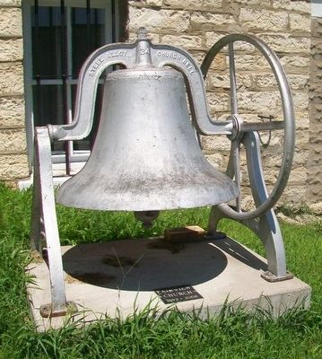
Near Zinnia Avenue at 460th Street, on the right when traveling north.
This bell has called people to God’s house to worship since 1869. It was first purchased and used by First Lutheran Church of St. Ansgar. In 1893 they gave it to Deer Creek Lutheran Church where it continued its call of worship across the . . . — — Map (db m16939) HM
Near Park Loop, 0.8 miles north of 225th Street, on the right when traveling north.
Mormon Influence
In 1853, as an expedition of Mormons crossed Iowa en route to Utah, 50 to 60 families left the main group to seek land to settle and to follow the teachings of their leader Charles B. Thompson, a former follower of Joseph . . . — — Map (db m236246) HM
On South Main Street north of Washington Avenue East, on the right when traveling north.
This building was also built in 1886. Unlike its neighbor it relied more on lower cost elements for architectural detailing. Notice the brick hoodmolds on the building which were not costly but added a degree of class to the building. The . . . — — Map (db m187842) HM
On Benton Avenue East (County Road H35) at North Clinton Street, on the right when traveling west on Benton Avenue East.
This building was built by Samuel Nobel in 1890. He was born November 30, 1819 in Hunting Co., Pennsylvania. In 1845 he moved to Fairfield, Iowa and four years later moved to Albia. At that time he started a dry goods store and ran that until 1865. . . . — — Map (db m188097) HM
On Cedar Street at East 2nd Street, on the right when traveling south on Cedar Street.
During a 10-day tour between Topeka court appearances, the temperance crusader stayed overnight and visited seven saloons including J.M. Wier’s at 221 E. 2nd St. She told a large audience in Muscatine’s Grand Opera House that she would not use her . . . — — Map (db m238746) HM
On Iowa Avenue just north of East 4th Street, on the right when traveling north.
This property is listed in The National Register of Historic Places Division of Historic Preservation Iowa State Historical Department — — Map (db m238796) HM
This bell was given to Westmar College for perpetual care by the Hoskins Evangelical United Brethren Church of Hoskins, Nebraska when it closed in 1979. Also given to the college were funds to establish the Hoskins Memorial Fund. The tower was . . . — — Map (db m118958) HM
On East 9th Street south of Thompson Avenue, on the right when traveling south.
Born in Philadelphia, Ida B. Wise Smith rose to national prominence as a Iowan dedicated to the causes of women's suffrage, prohibition, and children's rights. Mrs. Smith pressed her causes in the political arena, achieving the enactment of a state . . . — — Map (db m235889) HM
On 4th Street NW near Market Street NW, on the right when traveling west.
This church was built by Thomas Mitchell. Thomas Mitchell was born in New Hampshire in 1816. he came to Iowa Territory in 1840, and in 1844 became the first white settler of Polk County. He built cabins and later inns to feed and shelter the . . . — — Map (db m44833) HM
On Dumfries Avenue, 1.5 miles south of Pioneer Trail, on the right when traveling south.
Hyde Park was a small farming community just west of here, founded in 1847 by Mormon pioneers. It was named for Orson Hyde, an Apostle of The Church of Jesus Christ of Latter-Day Saints who took up residence here when he returned that spring from . . . — — Map (db m93960) HM
Near U.S. Highway 275 (U.S. 275) 0.1 miles Iowa Highway 92 (State Highway 92).
One of the most remarkable infantry marches in American history began here in July 1846 with the mustering of the Mormon Battalion. Members of The Church of Jesus Christ of Latter-day Saints (Mormon) responded to the request from President James K. . . . — — Map (db m22662) HM
On North Perry Street at East 14th Street, on the right when traveling north on North Perry Street.
This property is listed in
the National Register of Historic Places
Iowa State Historical Department
Division of Historic Preservation — — Map (db m202212) HM
On Iowa Street north of East 10th Street, on the right when traveling north.
In 1882 Bishop John McMullen, born in Ballynahinch, County Down, wanted a place to begin a college. The pastor of St. Marguerites Parish, Fr. Henry Cosgrove, offered two rooms in his parish grade school. There, on September 4, 1882, St. Ambrose . . . — — Map (db m202265) HM
On East 10th Street west of LeClaire Street, on the right when traveling west.
In 1856 Antoine LeClaire offered a parcel of land for the construction of a new Catholic Church in Davenport, which he eventually funded in total. This new church was to be built at the top of “Cork Hill,” an area between 6th and 13th Streets named . . . — — Map (db m202256) HM
On Farnam Street at East 7th Street, on the right when traveling north on Farnam Street.
The Gannon home was the residence of prominent lawyer, politician, and publisher, M.V. Gannon. Mr. Gannon came to America in October 1866 after leading a group of young Irish patriots in liberating Fenian prisoners from Kilmain Hall, Castle Kilrain. . . . — — Map (db m202244) HM
On Farnam Street at East 8th Street, on the left when traveling north on Farnam Street.
Fred B. Sharon and brother Thomas arrived in Davenport, Iowa in 1882. Together they published the Iowa Catholic Messenger which Thomas had established a few months prior to the move. Upon the death of Thomas, in 1888, Fred took over the management; . . . — — Map (db m202241) HM
On North Brady Street (State Highway 461) north of East 4th Street, on the right when traveling north. Reported missing.
The Ancient Order of Hibernians is an Irish Catholic fraternal society that originated in Ireland sometime between the 16th and the 18th century. In 1836, a group of Irish immigrants in New York City formed the first chapter of the AOH in America. . . . — — Map (db m202157) HM
On North Main Street at West 5th Street, on the right when traveling north on North Main Street. Reported unreadable.
Davenport's civil rights movement is unique because of the significant support it received from the local Catholic community, including the Catholic Diocese of Davenport and St. Anthony's Parish, in front of you. A significant number of parish . . . — — Map (db m202160) HM
On North Main Street at West 4th Street, on the right when traveling north on North Main Street.
est. 1837
by Rev. Samuel Mazzuchelli, O.P.
Listed 05 Apr 89
This property is listed in the
National Register of Historic Places
State Historical Society of Iowa — — Map (db m202158) HM
On 290th Street, 0.2 miles east of Veterans Way, on the right when traveling east.
Originated in 1852. The
original frame building
was erected in 1853 and is
now the vestry, moved to
Walnut Grove Pioneer
Village in 1985. — — Map (db m230351) HM
On 10th Street Southeast west of 2nd Ave Southeast, on the right when traveling west.
The First Reformed Church was organized May 17, 1877, in a school house two miles east of this site. A church was erected here in 1877, and later a larger one, which was destroyed by a tornado in 1902. The present brick building was built in 1902. — — Map (db m234290) HM
On Mt Pisgah Road, 0.5 miles south of 170th Street, on the right when traveling south.
(front of main marker)
Mt. Pisgah - Mormon Pioneer Way Station
Between 300 and 400 Mormon pioneers perished here from 1846 to 1852. Having been driven from their homes by armed mobs, they stopped here on their westward trek, named it . . . — — Map (db m20995) HM
On State Highway 16 at Teal Avenue, on the left when traveling east on State Highway 16.
Determined and authenticated by the Historical Department of Iowa, 1911.
This monument was erected in 1917 by the Iowa Daughters of the American Revolution in memory of the Pioneers who followed this trail and its tributaries.
We Cross The . . . — — Map (db m139803) HM
On North Mill Street just north of West Water Street, on the left when traveling north.
Overview Many immigrants found community in churches where people spoke their language and held familiar beliefs. Women played very important roles in building community in Norwegian Lutheran churches, even though they were not allowed to vote . . . — — Map (db m236298) HM
On College Drive (County Highway W38) just north of West Water Street, on the right when traveling north.
The Millrace: Harnessing Decorah’s Water Power Demosthenes, Greek statesman and orator of ancient Athens observed: "Small opportunities are often the beginning of great enterprises." During an 1848 scouting trip to appraise the . . . — — Map (db m239880) HM
On West Main Street at Winnebago Street, on the right when traveling east on West Main Street.
The Founding of Luther College Luther College opened in September 1861 in a vacant parsonage at Halfway Creek, Wisconsin, near La Crosse, with 11 students. The Norwegian Synod, the governing body of the Norwegian Lutheran . . . — — Map (db m242101) HM
On West Broadway Street at Court Street, on the right when traveling west on West Broadway Street.
The Courthouse Square Winneshiek County's courthouse square is typical of others found throughout the Midwest. Churches, businesses, the public library and homes ring the perimeter. But change has been a constant as the years have . . . — — Map (db m242600) HM
Near North Mill Street just north of West Water Street, on the right when traveling north.
Overview New immigrants often moved to existing ethnic communities where faith, food, and culture were familiar. Sometimes, these new immigrants would need to navigate shared living space and class differences with strangers along with living . . . — — Map (db m236297) HM
Near North Mill Street just north of West Water Street, on the right when traveling north.
Overview Nineteenth century Norwegian farmers grew food for their families instead of for income. Many farms in Norway used small water-powered mills to grind grain, press apples and process cloth. These mills were usually only big enough to . . . — — Map (db m236295) HM
On North Mill Street just north of West Water Street, on the right when traveling north.
Overview In the mid-19th century, a group of Norwegian immigrants who followed the state church in Norway wanted to create a system of schools associated with the church. Congregation members wanted to send their children to public schools to . . . — — Map (db m236299) HM
Near 2nd Street at 8th Avenue when traveling south.
The south enlisted men's barracks was a two-story log structure with raised stone platforms in the center of the foundations to help support the wooden floors. This building also served as a schoolroom for the officers' children and as a church on . . . — — Map (db m173850) HM
On 380 Street (County Route 380) at 188th Ave (County Route 188), on the right on 380 Street.
One of the oldest Society of Friends Congregations in Iowa organized here in 1855. First Meeting House built in 1856. Frame church erected on this site in 1879; destroyed by fire Oct. 22, 1904. Present church built in 1905. First Winneshiek County . . . — — Map (db m235046) HM
On County Road W14 just north of 225th Street, on the right when traveling north.
On this site stood two church buildings of the Lincoln Lutheran Congregation 1873-1914 1914-1968 The first building was removed to make way for the second. The second was destroyed by fire on June 9, 1968. The congregation merged with the Ridgeway . . . — — Map (db m235100) HM
Erected by Iowa Presbyterians
In Memory of
Rev. Sheldon Jackson
Rev. T.H. Cleland
Rev. J.C. Elliott
Pioneer Missionaries who on April 29, 1869 from this hill top viewed the great unchurched areas and after prayer went out to win . . . — — Map (db m121813) HM