By Raeann Braithwaite, June 4, 2023
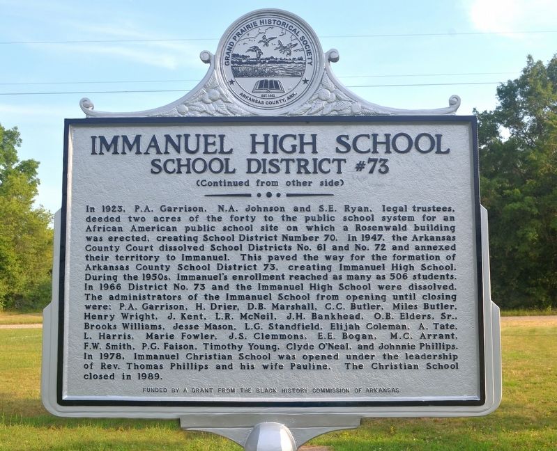
Immanuel High School Marker
| On Immanuel Road, 0.5 miles east of Arkansas Route 33, on the left when traveling east. |
| On State Highway 276 just east of Lumsden Road, on the left when traveling east. |
| On State Highway 276, 0.1 miles east of Riley Lane (Highway 276 Spur), on the left when traveling east. |
| On Buerkle Street, on the left when traveling south. |
| On South Main Street close to West 4th Street, on the right when traveling south. |
| On Lancashire Boulevard (State Highway 340) at Town Center, on the right when traveling east on Lancashire Boulevard. |
| On McClure Avenue (County Road 923) west of Jackson Street, on the right when traveling east. |
| On Jackson Street at McClure Avenue (County Road 923), on the right when traveling south on Jackson Street. |
| On Jackson Place at McClure Avenue (County Road 923), on the left when traveling north on Jackson Place. |
| On East Pickens Road (Arkansas Route 72) east of North Curtis Avenue, on the left when traveling east. |
| On 2nd Street (State Highway 12) at Walnut Street (State Highway 12), on the right when traveling south on 2nd Street. |
| On Poplar Street at 2nd Street, on the right when traveling east on Poplar Street. |
| On South Cherry Street at West Central Avenue, on the right when traveling south on South Cherry Street. |
| On Spring Street west of Hillside Avenue, on the right when traveling west. |
| On County Road 309, 0.1 miles north of County Road 3091, on the right. |
| Near State Highway 142, 0.9 miles Robert Mazzanti Road (Parish Road 505). |
| On Main Street at South 11th Street, on the right when traveling west on Main Street. |
| On State Highway 26, 0.1 miles east of State Highway 53, on the right when traveling west. |
| On Caddo Street at North 16th Street, on the right when traveling west on Caddo Street. |
| On Main Street at South 14th Street, on the right when traveling east on Main Street. |
| On West Church Street (State Road 113) at South Division Street, on the right when traveling east on West Church Street. |
| On South 3rd Street at Main Street, on the left when traveling south on South 3rd Street. |
| On North Currie Street east of Currie Avenue, on the left when traveling east. |
| On East Military Road at Briarwood Street, on the right when traveling east on East Military Road. |
| On East Military Road at Currie Avenue, on the right when traveling west on East Military Road. |
| On East Military Road at Cherry Avenue, on the right when traveling east on East Military Road. |
| Near State Highway 184, 0.6 miles north of U.S. 64, on the left when traveling north. |
| On State Highway 184, 0.6 miles north of U.S. 64, on the left when traveling north. |
| Near State Highway 184, 0.6 miles north of U.S. 64, on the left when traveling north. |
| Near State Highway 184, 0.6 miles north of U.S. 64, on the left when traveling north. |
| Near State Highway 184, 0.6 miles north of U.S. 64, on the left when traveling north. |
| On Arkansas Route 9, 0.2 miles north of County Road 409. |
| Near Arkansas Route 9 north of County Road 409, on the right when traveling north. |
| On North 2nd Street just north of Oak Street, on the left when traveling north. |
| Near Harkrider Street (Business U.S. 65) at Markham Street, on the right when traveling south. |
| On West Eucal Road (County Highway 9) at Unnamed road/driveway south of Eucal Road, on the right when traveling east on West Eucal Road. |
| On East College Avenue at South 7th Street, on the right when traveling east on East College Avenue. |
| Near East College Avenue east of South 7th Street, on the right when traveling east. |
| On West Hopewell Road at State Route 122, on the left when traveling west on West Hopewell Road. |
| On Lacrosse Road (Arkansas Route 9) at County Road 57, on the right when traveling south on Lacrosse Road. |
| On University Drive (U.S. 79) 0.2 miles south of Watson Boulevard, on the right when traveling south. |
| Near Old Ferry Road at West Seventh Street. |
| On Ramp Road north of Douglas Road, on the left when traveling north. |
| On Carter Lane, 0.2 miles south of Frazier Lane, on the left when traveling south. |
| On East 4th Street at North Oak Street, on the left when traveling east on East 4th Street. |
| On Greenlawn Street (U.S. 371) at De Ann Street, on the left when traveling west on Greenlawn Street. |
| On South Pine Street south of A Street, on the left when traveling south. |
| On Walnut Street at Perry Street, on the right when traveling north on Walnut Street. |
| On Columbia Street at Arkansas Street, on the right when traveling south on Columbia Street. |
| On Columbia Street (Business U.S. 49) at Arkansas Street, on the right when traveling south on Columbia Street. |
| On East Main Street at South Oak Street, on the right when traveling east on East Main Street. |
| Near Dean Kumpuris Street at East 3rd Street, on the right when traveling north. |
| On West 15th Street east of Dr. M.L.K. Jr Drive, on the left when traveling east. |
| On State Capitol north of West 4th Street / Capitol Mall, on the left when traveling north. |
| On W. 2nd Street, on the right when traveling east. |
| On Wright Avenue at South Ringo Street, on the right when traveling west on Wright Avenue. |
| On Carnall Avenue at South 8th Street (Arkansas Road 255), on the right when traveling west on Carnall Avenue. |
| On South West Avenue south of West Block Street, on the right when traveling south. |
| On Stephens Highway (Arkansas Route 57) south of Mt Holly Highway (Arkansas Route 160), on the right when traveling north. |
| On College Ave at McClellan Road on College Ave. |
| On College Road near McClellan Road, on the left when traveling north. |
| On North Lindell Avenue at West Douglas Street, on the right when traveling south on North Lindell Avenue. |
| On North College Avenue (Business U.S. 71) north of East Spring Street, on the right when traveling north. |
| Near North McIlroy Avenue. |
| On West Maple Street at North Lindell Avenue, on the right when traveling west on West Maple Street. |
| On West Maple Street at Garland Avenue, on the right when traveling east on West Maple Street. |
| On West Maple Street at Garland Avenue, on the left when traveling west on West Maple Street. |
| On West Mount Comfort Road (County Road 84) west of Rupple Road, on the right when traveling west. |
| On West Mountain Street at South Locust Avenue, on the right when traveling east on West Mountain Street. |
| Near West Maple Street west of Garland Avenue, on the right when traveling west. |
| Near North McIlroy Avenue. |
| On Arkansas Avenue north of Lafayette Street, on the left when traveling north. |
| On Arkansas Avenue, 0.1 miles south of West Maple Street, on the right when traveling south. |
| Near North Campus Walk south of West Maple Street, on the left when traveling south. |
| On Center Street at East Avenue, on the left when traveling west on Center Street. |
| On North Campus Walk south of West Maple Street, on the left when traveling south. |
| On East Dickson Street at North College Avenue (Business U.S. 71), on the right when traveling west on East Dickson Street. |
| On Garland Avenue at West Maple Street, on the right when traveling north on Garland Avenue. |
| On East Mission Boulevard (Arkansas Route 45) west of North Chapel View Road, on the right when traveling west. |
| Near North Campus Walk south of West Maple Street. |
| On West Maple Street at North Lindell Avenue, on the right when traveling west on West Maple Street. |
| Near West Maple Street east of Garland Avenue, on the right when traveling west. |
| On West Maple Street east of Garland Avenue, on the right when traveling east. |
| On Dickson Street near the railroad grade crossing, on the left when traveling west. |
| On Dickson Street at Arkansas Avenue, on the right when traveling west on Dickson Street. |
| On East Buchanan Street (Business U.S. 62) at North Neal Street, on the right when traveling west on East Buchanan Street. |
| On East Moore Avenue at North Horton Street, on the right when traveling west on East Moore Avenue. |
| On Quay Street (Arkansas Route 27) 0.3 miles west of North 10th Street, on the right when traveling west. |
| On State Highway 155, on the right when traveling north. |