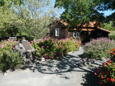
Walnut Creek's Old Borges Ranchhouse, as the cornerstone of a working cattle ranch, was first built by Frank (Francisco) and his wife Mary Borges, their sons and daughters in 1899. Since then, this house has withstood five generations of the hard . . . — — Map (db m93983) HM
Originally located at the Cereghino Ranch of Walnut Creek
Relocated to Shadelands in 1995
Restoration of the buildings was made possible by the efforts of:
Walnut Creek Historical Society
Joseph Bologna, Project Architect
Primo E. . . . — — Map (db m209652) HM
On Front Street at N Street, on the right when traveling east on Front Street.
These giant jacks are used to protect harbors from damaging current. As waves hit the tetrapods, the force of the water is dissipated by the curve of the legs. There are 1630 tetrapods on the ocean side of the Crescent City breakwater. There are . . . — — Map (db m181238) HM
This cabin is an example of he quarters used by miners during the gold rush. The earliest structures were canvas tents, made from recycled sailcloth taken from abandoned ships in San Francisco Bay. In 1849 Coloma had hundreds of “tent” cabins. When . . . — — Map (db m12270) HM
On State Highway 49, on the left when traveling south. Reported permanently removed.
The Sierra Nevada House was a handsome two-story building with many windows and a broad balcony. Here guests could always expect fine hospitality, suburb food, excellent ballroom music, fine carriages and comfortable beds. It was opened by Robert . . . — — Map (db m12237) HM
On Shaw Avenue near Forestiere Avenue, on the right when traveling east.
Here, beneath the hot, arid surface of the San Joaquin Valley, Baldasare Forestiere (1879-1946) began in the early 1900's to sculpt a fantastic retreat. Excavating the hardpan by hand, he created a unique complex of underground rooms, passages and . . . — — Map (db m41003) HM
Historical landmark
commemorating
Fresno Technical School,
constructed 1895.
Known as the Fresno High School
from 1895 - 1921.
Established as the First Junior College
of California, 1910.
Normal School - forerunner to
Fresno . . . — — Map (db m241689) HM
On Fresno Street near O Street, on the right when traveling east.
Designed by architect George S. Mayer of Chicago, Illinois. It was completed in November 1894, replacing two wooden tanks erected on this site in 1887. The Tower stands 100 feet high with a tank capacity of 250,000 gallons. This facility, modeled . . . — — Map (db m41069) HM
On 7th Street at H Street, on the left when traveling east on 7th Street.
In 1857, pioneer merchant Augustus Jacoby built
his two-story "Fireproof Storehouse" here of stone.
Partial walls of that original structure still support this building
in the N.W. corner of the 1st and 2nd floors and are . . . — — Map (db m182937) HM
On F Street at 3rd Street, on the right when traveling north on F Street.
Richardsonian Romanesque architecture
Samuel Newsom, Oakland architect; Built for
William Carson; Randall Banking; A. Crocker
Brothers Department Store; First Professional
Offices; Ingomar Theatre and Opera House.
Eureka Historic . . . — — Map (db m176802) HM
On F Street at 6th Street, on the right when traveling south on F Street.
Streamline Moderne Architecture
Built for George Mann; William B. David,
architect; striking neon blade sign,
curved-edge canopy, and Moderne interior
Eureka Historic Landmark — — Map (db m176787) HM
Built for J. McLauchlan, restaurant, saloons downstairs; alpine rooms upstairs; one of the longest operating bordellos
Eureka Historic Landmark
This program possible through a partnership with property owner Dr. Marybeth Wolford, Eureka . . . — — Map (db m1507) HM
Iron front cast by Eureka Foundry; men's clothier and furnishings, Louvre Cafe, saloons
Eureka Historic Landmark
This program possible through a partnership with property owner Wes & Nedra Kausen, Eureka Main Street, and the Eureka . . . — — Map (db m1508) HM
On C Street at Hillsdale Street, on the right when traveling south on C Street.
This property
is listed in the
National Register
of Historic Places
by the United States
Department of the Interior
John A. Cottrell House
c. 1902 — — Map (db m176767) HM
On 3rd Street west of G Street, on the right when traveling west.
Queen Anne Architecture
Built for Zipporah Russ & Sons Co.
Redwood Land & Investment Co.
Belcher & Crane Abstract Co.
Humboldt Club — Gentleman's Social Club
Eureka Historic Landmark — — Map (db m176808) HM
On G Street at 9th Street, on the right when traveling south on G Street.
904 G Street, Eureka
has been placed on the
National Register
of Historic Places
by the United States
Department of the Interior
1892 — — Map (db m176777) HM
On M Street at 2nd Street, on the left when traveling north on M Street.
This home, also known as the “Pink Lady,” is a classic Queen Anne/Eastlake Victorian residence designed by the prestigious architectural firm of Newsom Brothers of San Francisco. It was completed in 1889 for William Carson, a pioneer lumber baron . . . — — Map (db m1498) HM
Saloons, Kitty Farris' Joy Emporium, and Fairwind and New Fairwind Cafe.
This program possible through a partnership with owners Ferguson-Winsted, Eureka Main Street, and the Eureka Heritage Society. — — Map (db m61155) HM
On F Street at 6th Street, on the right when traveling south on F Street.
On Nov. 10, 1908, a deed from George and Edith Connick to Sunset Telephone and Telegraph Company, Block 56, Parcel 5, corner of 6th and “F” Streets was recorded. When Pacific Telephone and Telegraph took over the Sunset Telephone and Telegraph . . . — — Map (db m233368) HM
On G Street at 2nd Street, on the left when traveling north on G Street.
The Hotel Vance was built in 1872 by Eureka pioneer & lumberman,
John Vance. It was the area's grandest hotel & the first building in
Eureka with electricity. It was originally designed & built in the
"Modern Italianate style”, which . . . — — Map (db m135459) HM
Two-story, wood frame commercial building, originally with offices above three shops. Built for John Vance at same time as his adjoining Vance Hotel. A livery stable for guests of the hotel was adjacent to and behind, storefronts stuccoed in 1930s. . . . — — Map (db m233410) HM
On Main Street at Lewis Court, on the right when traveling south on Main Street.
Pioneer Seth Louis Shaw began construction of his home, Fern Dale, in 1854.
The town was named after his first permanent home.
The home, in its original condition, is a fine
example of Gothic architecture.
The house is a landmark
and a source . . . — — Map (db m220451) HM
On Main Street at Church Street, on the right when traveling west on Main Street.
The Wi'ne'ma Theatre was built in 1919 and named for a young
Indian girl who devoted her life to establishing friendly relations
between her people, the Modoc Indians, and the white men. The
first performance was on November 20, 1920 and tells . . . — — Map (db m142815) HM
On Hector Street at East Street, on the right when traveling north on Hector Street.
This property
Holy Trinity
Church
has been placed on the
National Register
of Historic Places
by the United States
Department of the Interior — — Map (db m176813) HM
On California Route 190, 0.2 miles east of Emigrant Canyon Road, on the right when traveling east.
Among the first structures greeting visitors entering
the park from the west, these two stone buildings at
Emigrant were built to serve as a ranger station and
are a legacy of the Civilian Conservation Corps
(CCC). Created by President Franklin . . . — — Map (db m159295) HM
On Edwards Street (U.S. 395) at Inyo Street, on the left when traveling north on Edwards Street.
The year 1861 found Charles Putnam gathering stones along Little
Pine Creek to build a cabin. The simple structure served as a trading
post for local miners and homesteaders who called the settlement
Little Pine. Conflicts between native . . . — — Map (db m225348) HM
On Fish Hatchery Road, 1 mile west of U.S. 395, on the right when traveling west.
In 1916, the citizens of Independence
purchased a 40 acre tract of land and
donated it to the State of California
for the building of a fish hatchery.
This structure was the result. The
first trout were produced in 1918, and
since that . . . — — Map (db m218383) HM
On Truxton Street near L Street, on the right when traveling west.
The First Baptist Church was completed under the supervision of local architect Charles H. Biggar (1882 - 1946) in 1932. The building, designed in the Northern Italian Romanesque architectural style, is described in the National Register of Historic . . . — — Map (db m117418) HM
On 17th Street at H Street, on the left when traveling west on 17th Street.
In 1889, First Presbyterian Church began its ministry in Kern County as Cumberland Presbyterian Church. In 1905 the church merged with Westminster Presbyterian; being renamed First Presbyterian Church of Bakersfield. The church acquired property on . . . — — Map (db m117142) HM
On Chester Avenue near 17th Street, on the right when traveling north.
George Haberfelde (1871 - 1962), a civic and business leader in the community, contracted with local architect Charles H. Biggar (1882 - 1946) to construct this five-story office and retail building in the Sullivanesque architectural style. When . . . — — Map (db m116966) HM
The Hayden Building is a classic example of Second Renaissance Revival architectural style. It was designed for the Kern County Land Company by San Francisco architect Charles I. Haven (1849-1916) and opened in 1904 as the Hayden Furniture Company. . . . — — Map (db m117419) HM
S.H. Kress & Co. was the trading name of a national chain of "five and dime" retail department stores operating from 1896 to 1981. Opening in 1931, this three-story reinforced steel and masonry building was designed by New York City-based architect . . . — — Map (db m115124) HM
On Chester Avenue, on the left when traveling north.
The decorative fence posts are from the original 1876 courthouse and the statues were on top of the 1912 courthouse.
Bakersfield's first courthouse was constructed in 1876 and the building served as a courthouse and hall of records on the . . . — — Map (db m237218) HM
In 1924, Bakersfield was the twenty-first city in California to receive a Federal Post Office Building. Built at a cost of $130,000, the Mission architecture style building, constructed of masonry and concrete and reinforced with steel, was the . . . — — Map (db m122018) HM
On Locust Street at Diamond Street, on the right when traveling east on Locust Street.
Immaculate Heart
of Mary Catholic
Church, established
Aug 12, 2015.
This building once
housed a Masonic
Lodge and the
church pictured below.
Wayside Community Chapel
Church, built in 1934 from land
donated by the LA Rescue . . . — — Map (db m186316) HM
In 1933 California’s first women’s prison was established in Tehachapi to provide an environment more conductive to rehabilitation than San Quentin State Prison. Two-story buildings were constructed of reinforced concrete in the French Normandy . . . — — Map (db m134503) HM
On Eighth Street east of Douty Street, on the right when traveling east.
Built with funds donated by philanthropist
Andrew Carnegie, this building served as
Hanford's Public Library from the time it opened
in February of 1906 until it was replaced by
a new library in 1968. It now houses a local
historical museum. — — Map (db m153547) HM
On Hackett Street west of 14th Avenue, on the right when traveling west.
Historical site - Kings County's First Church - Methodist organized - 14060 Hackett Street - est. 1876.
Kings County Historical Society — — Map (db m236174) HM
On 19½ Avenue (State Highway 41) at Lacy Boulevard when traveling south on 19½ Avenue.
This restored adobe, second oldest in San Joaquin Valley, built by Daniel Rhoades, who came to California in 1846 by overland caravan. Rhoades and his brother, John, among organizers of the first expedition to rescue the Donner party at Donner Lake. . . . — — Map (db m66412) HM
On Cory Avenue, 0.2 miles west of Crown Valley Road.
The first adobe schoolhouse in 1869 was located near Ravenna, and served the children of miners and ranchers covering a 2,500 square mile area. A subsequent structure, built in 1870, was destroyed by flood in 1880. The present brick schoolhouse, . . . — — Map (db m145704) HM
On Parkman Street, 0.1 miles east of Lake Avenue, on the right when traveling east.
Designed by Whitney R. Smith in
the Early Modern architectural
style and built in 1941 for Evelyn
and Jackson Holmes.
Designated
on February 9, 2021 by the Board
of Supervisors.
Historical Landmarks
and Records Commission. — — Map (db m192512) HM
On Mariposa Street east of Marengo Avenue, on the right when traveling east.
Zane Grey Estate, 396 East Mariposa Street, has been placed on the National Register of Historic Places by the United States Department of the Interior, 2002. — — Map (db m144782) HM
Near Mount Lowe Railway Trail south of Sam Merrill Trail.
The world famous Echo Mountain
House was completed in November 1894. It was a
beautiful L-shaped building, four stories high with a
400-foot wing offering a southern exposure. A massive
metal dome crowned the structure. The entire . . . — — Map (db m248028) HM
On First Avenue at Diamond Street, on the left when traveling south on First Avenue.
A Short History
In 1912 the first promotional organization to appear in Arcadia was a woman’s club called the Cooperative Arcadians. This group of 15 women began by sponsoring programs that increased interest in matters of social . . . — — Map (db m200010) HM
On Huntington Drive, 0.5 miles east of Baldwin Avenue, in the median.
With the demise of the famous Red Line electric railway, land in the median of Huntington Drive directly across from the famous Santa Anita Park horse track became available on which to build a headquarters for the Arcadia Chamber of Commerce in . . . — — Map (db m145281) HM
On First Avenue at Huntington Drive, on the right when traveling south on First Avenue.
Downtown Arcadia was born in 1887 with founder Elias J. "Lucky" Baldwin's Oakwood Hotel complimenting a new Santa Fe train station at First Avenue and Santa Clara Street. Expansion came with City incorporation in 1903 and again with the opening . . . — — Map (db m200045) HM
On First Avenue at California Street, on the right when traveling south on First Avenue.
In 1907, this yellow clapboard schoolhouse was built on the southwest corner of First Avenue and California Street, and it was named the Arcadia Grammar School. It replaced the temporary buildings, a packing shed, and a vacant remodeled saloon, . . . — — Map (db m200007) HM
Near Baldwin Avenue, 0.3 miles south of Interstate 210, on the right when traveling south.
Constructed by Elias Jackson ('Lucky') Baldwin in 1881. Designed by A.A. Bennett, and intended for entertaining. There being no kitchen, meals were served from the nearby adobe (built by Hugo Reid in 1839) where Baldwin actually lived. Restored and . . . — — Map (db m153410) HM
Near Baldwin Avenue, 0.3 miles south of Interstate 210, on the right when traveling south.
The home place of Elias Jackson “Lucky” Baldwin, founder and first Mayor of the City of Arcadia, was this relatively simple adobe house, though during Baldwin's occupation (1875-1909) it was the larger and more inviting structure seen . . . — — Map (db m153423) HM
Near Baldwin Avenue, 0.3 miles south of U.S. 210, on the right when traveling south.
Constructed about 1890 in Rancho Santa Anita by Atchison Topeka & Santa Fe Railroad on its transcontinental main line. Elias J. “Lucky” Baldwin donated right-of-way and bricks in exchange for agreement to stop trains, maintain a depot . . . — — Map (db m120309) HM
On Huntington Drive at First Avenue, on the right when traveling west on Huntington Drive.
Oldest operating racetrack in California - opened Christmas Day 1934.
Founded by Dr. Charles H. Strub & Associates.
Designed in Art Deco style by architect Gordon B. Kaufmann.
Introduced Santa Anita Handicap in 1935 - oldest . . . — — Map (db m201111) HM
Near Huntington Drive east of Baldwin Avenue, on the left when traveling east.
Set against the backdrop of the San Gabriel Mountains in an area of near year-round ideal weather, Santa Anita Park has been considered one of the most beautiful and finest horse race tracks in the world since its opening on Christmas Day 1934. . . . — — Map (db m198317) HM
On Huntington Drive, 0.3 miles west of the Foothill Freeway (Interstate 210), on the right when traveling west.
The Derby has a storied past in the City of Arcadia and, for many years, thoroughbred horse racing has shared a large part of that story. Arcadia’s founder and first Mayor, Elias J. ‘Lucky’ Baldwin presided over the first Santa Anita Racetrack in . . . — — Map (db m207738) HM
Near Avalon Canyon Road, on the left when traveling south.
There are five panels at the memorial. The first panel is in front of the memorial to the right. There is a duplicate panel located at the entrance, left of the walkway:
Wrigley Memorial is dedicated to the memory of Wm. Wrigley Jr. It . . . — — Map (db m69075) HM
Contained within this building are the remaining portions of an adobe house built by Francisco Salvador Lugo and his son Antonio María Lugo. Francisco Lugo was a prominent early landholder and Antonio served as the Alcalde of Los Angeles. They . . . — — Map (db m125567) HM
On Bellflower Boulevard at Mayne Street, on the left when traveling south on Bellflower Boulevard.
The view from Somerset (Bellflower) Boulevard in 1915, 10 years after the Santa Ana line first opened. On the left is PE substation #12. The Pacific Electric was an electrically powered interurban rail system. Power came from the company’s own . . . — — Map (db m133374) HM
On Rodeo Drive, 0.1 miles north of Wilshire Boulevard, on the right when traveling north.
Frank Lloyd Wright is perhaps the most celebrated and highly-recognized American architect.
His unique design for "The Anderton Court Shops" from 1952 represents the only retail
structure built by Wright in Southern California. He described . . . — — Map (db m200409) HM
On Moreno Drive, 0.1 miles north of Olympic Boulevard, on the left when traveling north.
Federal Emergency
Administration of Public Works.
John M. Garmody,
Administrator of Public Works.
Franklin D. Roosevelt,
President of the United States.
Beverly Hills High School, 1939. — — Map (db m183132) HM
On Doheny Road just west of Loma Vista Drive, on the right when traveling west.
Doheny Greystone Estate, an estate built by Edward L. Doheny Jr.
Designed by Gordon Kaufmann.
Landscape by Paul Thiene. Beverly Hills Historic Landmark No. 4.
Built 1928. Designated 2013.
Beverly Hills City Council and
Cultural Heritage . . . — — Map (db m192005) HM
On Sunset Boulevard at North Crescent Drive, on the right when traveling west on Sunset Boulevard.
Built as the first hotel in the City and associated
with architects Elmer Grey and Paul R. Williams.
Beverly Hills Historic Landmark No. 1.
Built 1912. Designated 2012.
Beverly Hills City Council and Cultural Heritage Commission, . . . — — Map (db m148025) HM
On Elden Way, 0.1 miles north of North Crescent Drive, on the right when traveling north.
United States Department of the Interior National Register of Historic Places.
Beverly Hills Local Landmark.
Constructed in 1911. — — Map (db m148656) HM
On Royal Oaks Drive North at Oaks Avenue, on the left when traveling west on Royal Oaks Drive North.
With the 1907 extension of Huntington’s Pacific
Electric system through Duarte to Glendora,
a cut was created to level the railroad’s right
of way in front of L.L. Bradbury’s country home.
To provide access to his home, the site of which
is now . . . — — Map (db m137592) HM
On February 28th, 1873, Doctor David Burbank sold a right-of-way through his property for one dollar, in anticipation
of the benefit that railway transportation would have on his property. This right-of-way provided the connection to
Los . . . — — Map (db m246759) HM
Near Buena Vista Street at Alameda Avenue, on the right when traveling north.
Stage three was built from 1953-1954 specifically for the scene in “20,000 Leagues Under the Sea” in which “Nautilus” was attacked by a giant squid. The complex filming involved using wind, rain and waves to create a storm.
The stage . . . — — Map (db m174848) HM
Near Buena Vista Street near Alameda Avenue, on the right when traveling north.
Stage Two, built from 1947-1949 in cooperation with Jack Webb,
was utilized as the production facility for the filming of the TV series
"Dragnet". Construction of the stage was completed in April, 1949.
Being one of the largest stages on . . . — — Map (db m174818) HM
Near Buena Vista Street at Alameda Avenue, on the right when traveling north.
The Animation Building, erected in 1939, served as the architectural
and functional centerpiece of the studio. Designed in the “Art
Moderne” style by architect Kent Weber, the building housed the
animators and story staffs on the lot.
. . . — — Map (db m168288) HM
Near Buena Vista Street at Alameda Avenue, on the right when traveling north.
Stage One was the only production sound stage built as part of
the original Walt Disney Burbank Studios constructed during
1939-1940. The stage replaced a single smaller stage located at the
Hyperion studios.
Since the original focus . . . — — Map (db m174816) HM
Near Buena Vista Street at Alameda Avenue, on the right when traveling north.
The Bungalow was built in 1935 as the original home of the
Disney Publicity and Comic Strip Departments. It was
constructed at the Disney Studios on Hyperion Avenue in
Hollywood and moved to the Burbank location as part of the
construction in . . . — — Map (db m174808) HM
Near Olive Avenue, 0.1 miles west of South Victory Boulevard, on the right when traveling west.
Built 1887. Relocated in 1977.
Original address 321 East Orange Grove.
Historic designation June 20, 2013.
Burbank Register of
Residential Historic Resources #7.
1887 Mentzer House
Built by the Providencia Land and
Water . . . — — Map (db m246736) HM
Near Buena Vista Street at Alameda Avenue, on the right when traveling north.
The Shorts Building was constructed from the two original
Animation Buildings located at the Disney Studios on
Hyperion Avenue in Hollywood. The two sections were
moved to the Burbank site in 1939-1940 as part of the Studio
construction . . . — — Map (db m174812) HM
Near Olive Avenue at Pass Avenue, on the right when traveling north.
Constructed in 1935 by
Harry, Jack and Albert Warner,
this building has been home to such
celebrated Warner Bros.
writers and filmmakers as
William Faulkner ·
Howard Koch ·
Delmer Daves ·
Lillian Hellman ·
John Huston ·
Philip and . . . — — Map (db m177206) HM
On Las Virgenes Road, 0.2 miles south of Willow Glen Street, on the right when traveling south.
The Schoolhouse Bell once hung in the original Calabasas School, a one
room Victorian style building with a bell tower, which was constructed in
1890 at 24454 Calabasas Road. Around 1925, a new Spanish Colonial
Revival style structure was built . . . — — Map (db m156909) HM
On Clover Trail just east of Canyon Drive, on the left when traveling east. Reported missing.
Completed in 1984 for Robert Benson, this dwelling was designed by renowned architect Frank Gehry in the Deconstructivism style. This architectural style is characterized by its use of unrelated, disharmonious abstract forms, and experimental . . . — — Map (db m156936) HM
On Park Belmonte, 0.5 miles west of Park Sienna, on the right when traveling west.
Jerold Lomax, FAIA, designed and built this single family residence for Mr. & Mrs. Arthur Rouse in 1973. The structure is constructed of 40-foot and 25-foot-long glue-laminated wood beams, supported by eight concrete pillars. For the time, this was . . . — — Map (db m156912) HM
On Black Bird Way, 0.1 miles south of Blue Bird Drive, on the right when traveling south.
Designed by the architect Jock Peters, the Park Moderne Fountain is the only remaining fountain constructed as part of the artists colony known as Park Moderne — a residential subdivision created in 1927 with 174 lots. The Art Deco era . . . — — Map (db m156932) HM
Near Mulholland Highway, 0.1 miles east of Las Virgenes Road, on the right when traveling east.
Now the hub of Santa Monica Mountains National
Recreation Area, the King Gillette Ranch was once
an estate belonging to King Camp Gillette, who
invented the disposable razor blade. Gillette bought
the
property
in 1926 and commissioned . . . — — Map (db m191215) HM
On Harvard Avenue at 2nd Street, on the right when traveling south on Harvard Avenue.
Claremont's municipal offices have occupied one or more of the buildings at this location
since 1925. City officials have made several decisions over the years to keep City Hall in
the Village in order to help protect the vitality of the Village . . . — — Map (db m149814) HM
On 1st Street at Harvard Avenue, on the left when traveling west on 1st Street.
The Atchison, Topeka & Santa Fe Railroad and its subsidiary, the Pacific
Land Improvement Company, founded the town of Claremont in 1887. The
railroad's original wooden, Gothic depot was replaced by this Spanish
Colonial Revival structure in . . . — — Map (db m149721) HM
This historic setting of the Pitzer House and Garage was preserved in the year 2000 by Sunrise Assisted Living as a major architectural landmark of the City of Claremont. Sunrise carefully restored the Pitzer House residence to serve as its . . . — — Map (db m244782) HM
The firehouse-jail was the first civic building
commissioned by the city of Covina. The mission
revival structure was constructed in 1911 by pioneer builder Clarence Allison. When a new city hall and fire station was built in 1930, the fire . . . — — Map (db m138043) HM
On Duquesne Avenue at Washington Boulevard, on the left when traveling south on Duquesne Avenue.
The Culver Theater, which opened in 1947, was one of two movie theaters in Culver City operating in the second half of the 20th century. As an example of the Skouras style, it was noted for its sweeping scrollwork and a juke box like ticket kiosk. — — Map (db m137095) HM
On Firestone Boulevard at Pomering Road, on the right when traveling west on Firestone Boulevard.
This building is a great example of the “Googie style” coffee shops and drive-in restaurants that once dotted the Southern California landscape. Googie Architecture called for buildings to read as signs to attract customers. Built in . . . — — Map (db m149050) HM
On Manhattan Avenue west of La Crescenta Avenue, on the right when traveling west.
Historic Thomas and Florence Bonetto
House, 2819 Manhattan Avenue,
constructed in 1931, Glendale Register of Historic Resources No. 62.
The Bonettos were true community leaders and
instrumental in the growth of the Crescenta Valley. — — Map (db m198188) HM
Near East Palmer Avenue at South Adams Street, on the left when traveling south.
Built in 1936 by Richfield Oil Corporation. Rare surviving example of a
streamline moderne gas station, significant for its association with
the development of Southern California car culture. — — Map (db m140830) HM
On Chevy Chase Drive just east of St Andrews Drive, on the left when traveling east.
This property, Derby House,
has been placed on the
National Register
of Historic Places
by the United States
Department of the Interior.
The Derby House - 1926.
Lloyd Wright, architect.
City of Glendale Historical . . . — — Map (db m209237) HM
On Cedar Street north of Broadway, on the left when traveling north.
Built in the 1880’s. One of the last remaining examples of Queen Anne-Eastlake architectural style in Glendale. Home of Ed Goode, 1897-1917, outstanding community leader. — — Map (db m143602) HM
On Brand Boulevard south of California Avenue, on the left when traveling south.
Alex Theatre has been placed on the National Register of Historic Places by the United States Department of the Interior.
1925 Theatre Building — Arthur G. Lindley & Charles R. Selkirk, architects.
1940 Marquee & Tower — S. Charles Lee, . . . — — Map (db m145347) HM
On Broadway just west of Kenwood Street, on the right when traveling west.
This property has been
placed on the
National Register
of Historic Places
by the United States
Department of the Interior.
This building
is named in
honor of
Carlos J.
Moorhead
by Act of
Congress,
Public Law 105-88,
November . . . — — Map (db m209982) HM
On Louise Street, 0.1 miles north of Broadway, on the right when traveling north.
Established in 1919. Constructed in 1926. Designed by Clarence L. Jay and Lincoln Rogers.
Spanish Colonial Revival architecture.
City of Glendale Historical Landmark. — — Map (db m210004) HM
On Brand Boulevard just north of Colorado Street, on the right when traveling north.
The Masonic Temple was dedicated on June 11, 1929 and served as a
meeting place for several Masonic Lodges for nearly three decades.
The building, constructed by J.V. McNeil, was designed by architect and
engineer Arthur Lindley who was also . . . — — Map (db m214526) HM
1213 entries matched your criteria. Entries 101 through 200 are listed above. ⊲ Previous 100 — Next 100 ⊳