After filtering for Missouri, 856 entries match your criteria. The first 100 are listed. ⊳
Industry & Commerce Topic
By Michael E Sanchez, Jr., March 24, 2017
Adair County, Missouri Courthouses Marker back
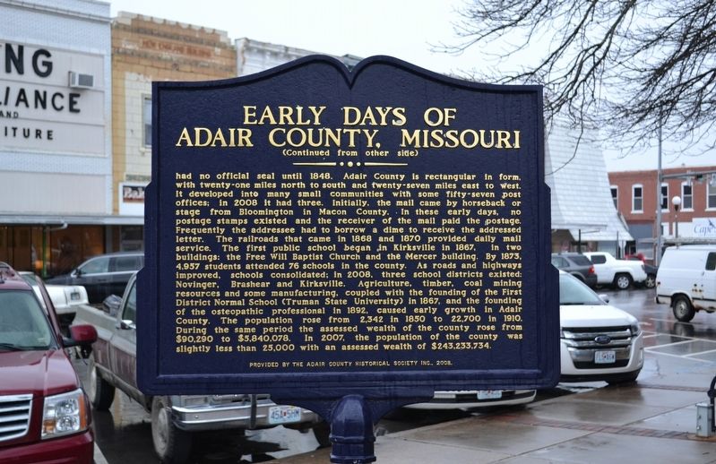
| 1 ► Missouri, Adair County, Kirksville — Adair County, Missouri Courthouses / Early Days of Adair County, Missouri — |
| On North Elson Street just south of West Harrison Street, on the left when traveling south. | |||
| 2 ► Missouri, Atchison County, Rock Port — Rock Port — |
| On U.S. 136 at Market Street, on the left when traveling west on U.S. 136. | |||
| 3 ► Missouri, Audrain County, Mexico — Bonnot Combined Brick Machine — 1904 • 1926 — |
| Near Missouri Route 15. | |||
| 4 ► Missouri, Audrain County, Mexico — Diaspore Boulder — Weight 10,400 Lbs. — |
| Near Missouri Route 15. | |||
| 5 ► Missouri, Audrain County, Mexico — John Bingle Morris — |
| On Jefferson Street at Monroe Street, on the left when traveling north on Jefferson Street. | |||
| 6 ► Missouri, Audrain County, Mexico — Mexico — |
| On Mudrow Street (Missouri Route 15) at Hisey Street, on the right when traveling south on Mudrow Street. | |||
| 7 ► Missouri, Audrain County, Mexico — Old Stones — |
| Near Missouri Route 15. | |||
| 8 ► Missouri, Audrain County, Mexico — The Green Estate — |
| On Clark Street (U.S. 54) at Hendy Street, on the right when traveling north on Clark Street. | |||
| 9 ► Missouri, Barton County, Lamar — Lamar — |
| On Gulf Street at 11th Street West, on the right when traveling north on Gulf Street. | |||
| 10 ► Missouri, Bates County, Butler — Palace Office Building — |
| On Ohio Street at Main Street, on the right when traveling west on Ohio Street. | |||
| 11 ► Missouri, Bates County, Rich Hill — The Town That Coal Built — Rich Hill, Missouri — "Big Mouth" — |
| On 7th Street at Park Street, on the left when traveling south on 7th Street. | |||
| 12 ► Missouri, Benton County, Warsaw — Butterfield Overland Mail in Missouri — 1858-1861 — |
| On Van Buren Street at Main Street, on the right when traveling north on Van Buren Street. | |||
| 13 ► Missouri, Bollinger County, Marble Hill, Lorance Township — Mineral Well — |
| On High Street just south of Water Street, on the left when traveling south. | |||
| 14 ► Missouri, Boone County, Columbia — "Make A Brighter Future" — |
| On East Stewart Road just west of South Providence Road (State Highway 163), in the median. | |||
| 15 ► Missouri, Boone County, Columbia — 3rd Street Market, Blue & White Café, and the Harvey House — |
| On North Providence Road (State Highway 163) just north of Switzler Street, on the left when traveling north. | |||
| 16 ► Missouri, Boone County, Columbia — African American Heritage Trail — |
| On Park Avenue just east of North Providence Street (State Highway 163), on the right when traveling east. | |||
| 17 ► Missouri, Boone County, Columbia — African-American Heritage — Flat Branch Park — |
| On South 4th Street at Cherry Street, on the right when traveling south on South 4th Street. | |||
| 18 ► Missouri, Boone County, Columbia — African-American Heritage Trail — |
| On East Broadway just east of North 4th Street, on the left when traveling east. | |||
| 19 ► Missouri, Boone County, Columbia — African-American Heritage Trail — |
| On North 5th Street at East Walnut Street, on the right when traveling north on North 5th Street. | |||
| 20 ► Missouri, Boone County, Columbia — African-American Heritage Trail — |
| On North 5th Street just north of East Ash Street, on the left when traveling north. | |||
| 21 ► Missouri, Boone County, Columbia — African-American Heritage Trail — |
| On North Garth Avenue at East Ash Street, on the right when traveling north on North Garth Avenue. | |||
| 22 ► Missouri, Boone County, Columbia — African-American Heritage Trail — |
| On North Providence Road (State Highway 163) at East Ash Street, on the left when traveling north on North Providence Road. | |||
| 23 ► Missouri, Boone County, Columbia — African-American Heritage Trail — |
| On Switzler Street just west of Lasalle Place, on the right when traveling west. | |||
| 24 ► Missouri, Boone County, Columbia — African-American Heritage Trailhead — |
| On South 4th Street at Cherry Street, on the right when traveling south on South 4th Street. | |||
| 25 ► Missouri, Boone County, Columbia — Annie Fisher's House — African-American Heritage Trail — |
| On Park Avenue at North 7th Street, on the right when traveling east on Park Avenue. | |||
| 26 ► Missouri, Boone County, Columbia — Commerce — Flat Branch Park — |
| On South 4th Street at Cherry Street, on the right when traveling south on South 4th Street. | |||
| 27 ► Missouri, Boone County, Columbia — Missouri, Kansas & Texas Railroad Depot — |
| On South 4th Street at East Broadway, on the right when traveling north on South 4th Street. | |||
| 28 ► Missouri, Boone County, Columbia — Sharp End — |
| On East Walnut Street just east of North 5th Street, on the right when traveling east. | |||
| 29 ► Missouri, Boone County, Columbia — Tibbs Building — African American Heritage Trail — |
| On East Walnut Street at North 5th Street, on the right when traveling east on East Walnut Street. | |||
| 30 ► Missouri, Boone County, Columbia — Transportation — Flat Branch Park — |
| On South 4th Street at Cherry Street, on the right when traveling south on South 4th Street. | |||
| 31 ► Missouri, Boone County, Rocheport — History of Rocheport — |
| 32 ► Missouri, Boone County, Rocheport — Steamboating on the Missouri — |
| 33 ► Missouri, Buchanan County, St. Joseph — Donnell Court Building — Neo-Classical — 1902 — |
| On Francis Street at 5th Strret, on the left when traveling east on Francis Street. | |||
| 34 ► Missouri, Buchanan County, St. Joseph — German-American Bank — Richarsonian Romanesque — 1889 — |
| On 7th Street at Felix Street, on the right when traveling south on 7th Street. | |||
| 35 ► Missouri, Buchanan County, St. Joseph — Joseph Robidoux at Roy's Branch — |
| 36 ► Missouri, Buchanan County, St. Joseph — Kirkpatrick Building — Beaux Arts — 1923 — |
| On Francis Street at 7th Street, on the right when traveling east on Francis Street. | |||
| 37 ► Missouri, Buchanan County, St. Joseph — Krug Building — Queen Anne — 1904 — |
| On 8th Street at Francis Street, on the right when traveling south on 8th Street. | |||
| 38 ► Missouri, Buchanan County, St. Joseph — Missouri Valley Trust Company — Commercial Italianate — 1859 — |
| On 4th Street at Felix Street, on the right when traveling north on 4th Street. | |||
| 39 ► Missouri, Buchanan County, St. Joseph — Pony Express Stable — |
| On Penn Street west of South 10th Street, on the left when traveling west. | |||
| 40 ► Missouri, Buchanan County, St. Joseph — Saint Joseph — |
| On Penn Street, on the left when traveling east. | |||
| 41 ► Missouri, Buchanan County, St. Joseph — The California - Oregon Trail — 1840s & 1850s — |
| 42 ► Missouri, Buchanan County, St. Joseph — The Journey West — |
| On South 3rd Street near Edmond Street, on the left when traveling south. | |||
| 43 ► Missouri, Buchanan County, St. Joseph — The Patee House In The Civil War — A State Divided: The Civil War in Missouri — |
| On Penn Street at 12th Street, on the right when traveling east on Penn Street. | |||
| 44 ► Missouri, Caldwell County, Hamilton — "Richey" Mill Stones — |
| On McGaughy Street west of Davis Street (Missouri Route 13), on the right when traveling west. | |||
| 45 ► Missouri, Caldwell County, Hamilton — Boyhood Home of J. C. Penney — |
| On Davis Street (Missouri Route 13) at McGaughy Street, on the left when traveling north on Davis Street. | |||
| 46 ► Missouri, Caldwell County, Hamilton — Harden Stone Millstones — |
| On West McGaughy Street just west of North Davis Street (State Highway 13), on the right when traveling west. | |||
| 47 ► Missouri, Caldwell County, Hamilton — Welcome to Hamilton — |
| On Davis Street (Missouri Route 13) at McGaughy Street, on the left when traveling north on Davis Street. | |||
| 48 ► Missouri, Caldwell County, Hamilton — Welcome to Hamilton — Quilt Town, USA — Find Your Happy Place — |
| On Davis Street at McGaughy Street, on the left when traveling north on Davis Street. | |||
| 49 ► Missouri, Callaway County, Jefferson City — Jefferson City & Fulton Points of Interest — |
| Near Katy Road, 0.9 miles north of Oilwell Road, on the right when traveling north. | |||
| 50 ► Missouri, Callaway County, Tebbetts — Fur Trading in Missouri — Milepost 131.3 — |
| On Olive Street (County Route 485) south of County Route 4011, on the left when traveling north. | |||
| 51 ► Missouri, Camden County, Ha Ha Tonka — Water: Sculpting The Landscape — Ha Ha Tonka State Park — Missouri State Parks — |
| On Natural Bridge Road, 0.5 miles west of State Highway D, on the left when traveling west. | |||
| 52 ► Missouri, Cape Girardeau County, Burfordville — Bollinger Mill/Burfordville Covered Bridge — |
| On County Road 360, 0.1 miles east of State Highway OO, on the right when traveling east. | |||
| 53 ► Missouri, Cape Girardeau County, Cape Girardeau — 1735 — Girardot Post — |
| On North Water Street north of Broadway Street, on the right when traveling north. | |||
| 54 ► Missouri, Cape Girardeau County, Cape Girardeau — 1875 — River Commerce — |
| On North Water Street at Themis Street, on the left when traveling south on North Water Street. | |||
| 55 ► Missouri, Cape Girardeau County, Cape Girardeau — 1980 — Riverfest — |
| On Water Street. | |||
| 56 ► Missouri, Cape Girardeau County, Cape Girardeau — Cape Girardeau — |
| On North Kingshighway Street (U.S. 61) at South County Park Road, on the right when traveling south on North Kingshighway Street. | |||
| 57 ► Missouri, Cape Girardeau County, Cape Girardeau — Captains of Industry — |
| On Water Street. | |||
| 58 ► Missouri, Cape Girardeau County, Cape Girardeau — Dwarfing the Titanic — Did you Know? — |
| On North Water Street. | |||
| 59 ► Missouri, Cape Girardeau County, Cape Girardeau — Filburn & Sloan Commission House — Old Town Cape — |
| On North Water Street at Themis Street, on the right when traveling south on North Water Street. | |||
| 60 ► Missouri, Cape Girardeau County, Cape Girardeau — George & Fred Naeter — 1904-1954 — |
| On Kiwanis Drive at Maria Louise Lane, on the right when traveling west on Kiwanis Drive. | |||
| 61 ► Missouri, Cape Girardeau County, Cape Girardeau — H&H Building — |
| On Broadway Street just west of North Fountain Street, on the right when traveling west. | |||
| 62 ► Missouri, Cape Girardeau County, Cape Girardeau — Manitowoc Shipbuilding Company — |
| Near Aquasmi Street, on the right when traveling south. | |||
| 63 ► Missouri, Cape Girardeau County, Cape Girardeau — Marquette Tower — |
| On Broadway Street just east of North Fountain Street, on the left when traveling east. | |||
| 64 ► Missouri, Cape Girardeau County, Cape Girardeau — Reflecting the River — Did You Know? — |
| Near Broadway Street just east of North Water Street, on the left when traveling east. | |||
| 65 ► Missouri, Cape Girardeau County, Cape Girardeau — The Southeast Missourian Building — Old Town Cape — |
| On North Lorimier Street at Broadway Street, on the left when traveling north on North Lorimier Street. | |||
| 66 ► Missouri, Carter County, Van Buren — CCC - A Peace-Time Army — |
| On State Highway Z at Pea Vine Road (State Highway 103), on the right when traveling north on State Highway Z. | |||
| 67 ► Missouri, Carter County, Van Buren — Van Buren — |
| On Main Street (Business U.S. 60) at Oliver Street, on the right when traveling north on Main Street. | |||
| 68 ► Missouri, Cass County, Pleasant Hill — 100 Veterans Parkway — Historic Building circa 1880 — |
| On Veterans Parkway at Cedar Street, on the right when traveling north on Veterans Parkway. | |||
| 69 ► Missouri, Cass County, Pleasant Hill — 110 South Lake Street — Historic Building circa 1909 — |
| On Veterans Parkway south of Cedar Street, on the left when traveling south. | |||
| 70 ► Missouri, Cass County, Pleasant Hill — 111 First Street — Historic Building 1870 — |
| On 1st Street north of Commercial Street, on the right when traveling north. | |||
| 71 ► Missouri, Cass County, Pleasant Hill — 113 Wyoming Street — Historic Building 1891 — |
| On Wyoming Street at 1st Street, on the right when traveling west on Wyoming Street. | |||
| 72 ► Missouri, Cass County, Pleasant Hill — 117 First Street — Historic Building circa 1895 — |
| On 1st Street north of Commercial Street, on the right when traveling north. | |||
| 73 ► Missouri, Cass County, Pleasant Hill — 118 First Street — Historic Building circa 1903 — |
| On 1st Street south of Wyoming Street, on the right when traveling south. | |||
| 74 ► Missouri, Cass County, Pleasant Hill — 119 First Street — Historic Building circa 1907 — |
| On 1st Street north of Commercial Street, on the right when traveling north. | |||
| 75 ► Missouri, Cass County, Pleasant Hill — 120 First Street — Historic Building — |
| On 1st Street south of Wyoming Street, on the right when traveling south. | |||
| 76 ► Missouri, Cass County, Pleasant Hill — 121 First Street — Historic Building 1894 — |
| On 1st Street north of Commercial Street, on the right when traveling north. | |||
| 77 ► Missouri, Cass County, Pleasant Hill — 124 First Street — Historic Building 1893 — |
| On 1st Street south of Wyoming Street, on the right when traveling south. | |||
| 78 ► Missouri, Cass County, Pleasant Hill — 126 First Street — Historic Building 1900 — |
| On 1st Street south of Wyoming Street, on the right when traveling south. | |||
| 79 ► Missouri, Cass County, Pleasant Hill — 129 Wyoming Street — Historic Building 1920 — |
| On Wyoming Street west of 1st Street, on the right when traveling west. | |||
| 80 ► Missouri, Cass County, Pleasant Hill — 134 First Street — Historic Building circa 1890 — |
| On 1st Street south of Wyoming Street, on the right when traveling south. | |||
| 81 ► Missouri, Cass County, Pleasant Hill — 135 First Street — Historic Building 1884 — |
| On Commercial Street at 1st Street, on the left when traveling east on Commercial Street. | |||
| 82 ► Missouri, Cass County, Pleasant Hill — 136 First Street — Historic Building circa 1868 — |
| On 1st Street north of Commercial Street, on the left when traveling north. | |||
| 83 ► Missouri, Cass County, Pleasant Hill — 140 First Street — Historic Building 1868 — |
| On Commercial Street at 1st Street, on the right when traveling west on Commercial Street. | |||
| 84 ► Missouri, Cass County, Pleasant Hill — 400 Cedar St. — Historic Building circa 1860 — |
| On Cedar Street at Taylor Street, on the right when traveling east on Cedar Street. | |||
| 85 ► Missouri, Cass County, Pleasant Hill — Historic 115 Wyoming Street — 1866 — |
| On Wyoming Street at 1st Street, on the right when traveling west on Wyoming Street. | |||
| 86 ► Missouri, Cass County, Pleasant Hill — Missouri Pacific Railroad Depot — Historic Building circa 1903 — |
| On Boardman Street south of Paul Street / Wyoming Street, on the right when traveling south. | |||
| 87 ► Missouri, Cass County, Pleasant Hill — Pleasant Hill, Missouri — |
| On Veterans Parkway (AKA Lake Street) at Paul Street, on the right when traveling south on Veterans Parkway (AKA Lake Street). | |||
| 88 ► Missouri, Cedar County, El Dorado Springs — Grindstone Wash Basin — |
| 89 ► Missouri, Cedar County, El Dorado Springs — Nathaniel H. and Waldo P. Cruce — 1857 - 1925 and 1861 - 1904 — |
| 90 ► Missouri, Chariton County, Brunswick — "World's Largest Pecan" — James Family — |
| On West Broadway Street (U.S. 24) east of South Polk Street, on the left when traveling east. | |||
| 91 ► Missouri, Chariton County, Keytesville — Keytesville — |
| On West Jackson Street (U.S. 24) east of South Cherry Street, on the right when traveling east. | |||
| 92 ► Missouri, Christian County, Ozark — Commercial Block — 1897 — |
| On 2nd Street north of Elm Street, on the right when traveling south. | |||
| 93 ► Missouri, Christian County, Ozark — Commercial Building — 1914 — |
| On Elm Street west of 2nd Street, on the left when traveling west. | |||
| 94 ► Missouri, Clark County, Athens — Athens Mills — |
| Near State Highway CC at County Road 81. | |||
| 95 ► Missouri, Clark County, Athens — Businesses in Athens, circa 1853-1860 — |
| Near County Road 81 (County Highway 81) at County Highway CC, on the right when traveling west. | |||
| 96 ► Missouri, Clark County, Athens — The Athens General Store — |
| Near County Road 81 at County Highway CC. | |||
| 97 ► Missouri, Clark County, Kahoka — Clark County — |
| On North Johnson Street (Missouri Route 81) north of East Court Street, on the right when traveling north. | |||
| 98 ► Missouri, Clay County, Excelsior Springs — Hall of Waters — |
| On Main Street at Spring Street, on the left when traveling south on Main Street. | |||
| 99 ► Missouri, Clay County, Excelsior Springs — Hall of Waters — Clay County Historical Society — Historic Landmark — |
| On South Main Street at Spring Street, on the right when traveling north on South Main Street. | |||
| 100 ► Missouri, Clay County, Kansas City, Wheeler Downtown Airport — Charles B. Wheeler Downtown Airport — |
| Near Richards Road. | |||
856 entries matched your criteria. The first 100 are listed above. Next 100 ⊳