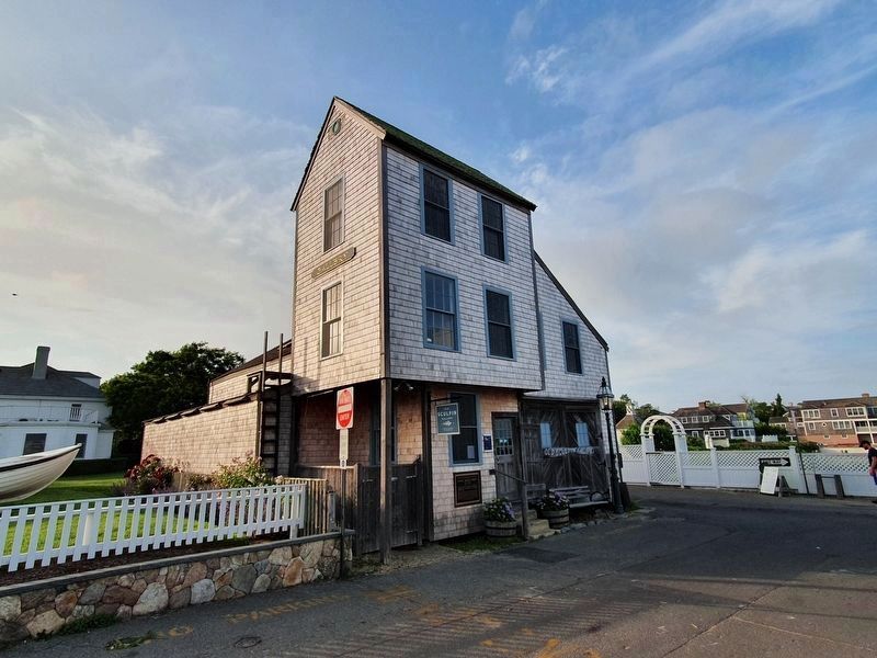
On Dock Street east of Kelly Street, on the left when traveling east.
For many years this building was the shop
of Manuel Swartz Roberts Boat builder
1881-1963 From its doors came catboats, beach boats, fishing boats, all staunch, all honest, all seaworthy, all partaking of the nature of their builder. Thru . . . — — Map (db m177816) HM
On Dock Street east of Kelly Street, on the right when traveling east.
Ovid Osborn Ward, sculptor, is the great-grandson of Samuel Osborn, Jr. who owned Osborn's Wharf (now the site of the Edgartown Yacht Club) where whaleships, including his own,
returned from their long voyages and were
outfitted to sail again to . . . — — Map (db m177822) HM
On Seaview Avenue at Oak Bluffs Avenue, on the right when traveling north on Seaview Avenue.
Originally built in 1931, this bathhouse was designed in the late Victorian era Craftsman style to compliment the original brick Steamship Authority ferry terminal. The building was made of the best materials and most modern plumbing available . . . — — Map (db m84144) HM
On Morgan Avenue north of Glenwood Avenue, on the left when traveling north.
Charles Shearer was born into slavery in
Appomattox, Virginia. In 1880, he graduated from
Hampton Institute and served on the faculty for
twelve years. Later, Charles and his wife, Henrietta, purchased two homes, in Everett, Mass. and Oak . . . — — Map (db m177789) HM
On Main Street south of Spring Street, on the right when traveling south.
African-American Heritage Trail of Martha’s Vineyard honors William "Barber" Hammond an African American entrepreneur who bought property and opened his barber shop in 1880 on this site February 2010 — — Map (db m177621) HM
On State Road north of Music Street, on the left when traveling north.
Alley’s General Store 1858 Restored and maintained by the Martha’s Vineyard Preservation Trust Acquired in 1993 through the generous contributions of Islanders to preserve the heritage of Martha’s Vineyard. — — Map (db m178153) HM
On Rocky Hill Road north of Macy Road (Massachusetts Route 110), on the left when traveling north.
This rail trail follows the Salisbury branch of the Eastern Railroad that connected the mills along the Powwow River to the main line. The branch started operation in 1848 and the last train rain in 1965.
The trail offers a peaceful multi-use . . . — — Map (db m205045) HM
On Water Street, on the left when traveling north.
From 1632-1754 a few farms and native American habitations dotted the woodlands among this land originally granted to pioneer settlers Gov. John Endecott and Rev. Samuel Skelton. On the road to Salem lay the farm of George Jacobs, Sr., a victim . . . — — Map (db m43938) HM
On Maple Street near Central Ave, on the right when traveling north.
Called "Porter's Plain" after 17th century settler
John Porter, this level expanse of about one square
mile was sparsely inhabited into the mid-18th century.By the time of the American Revolution, patriot
Captain Jeremiah Page had settled here, . . . — — Map (db m38341) HM
On Main Street (Massachusetts Route 133), on the left when traveling east.
Dedicated to the those men of Chebacco and Essex who by the skill of mind and hand within sight of this spot created nearly 4000 wooden vessels 1650-1982 — — Map (db m97208) HM
On Main Street (Massachusetts Route 133), on the right when traveling north.
In 1668 the town granted the
adjacent acre of land "To the
inhabitants of Ipswich for a yard
to build vessels and to employ
workmen for that end."
The shipbuilding industry has
continued uninterruptedly in
Essex since that date. — — Map (db m47495) HM
Near Rogers Street (Massachusetts Route 127) east of Porter Street when traveling south.
Cape Ann lies on an outcropping composed of 450 million-year-old granite polished by glaciers. This particularly dense stone was prized for building monuments, forts, and piers. Blocks of Cape Ann granite were used to build Gloucester's Dale . . . — — Map (db m115434) HM
On Rogers Street (Massachusetts Route 127) west of Duncan Street, on the right when traveling east.
Charles Heberle (1862-1956) was sent at age 13 from Virginia to Essex, where for three years he was indentured to the Essex Tannery. Once free, he worked nearby for a dairy farmer, Caleb Cogswell.
Soon, Heberle chose waterfront over farm and . . . — — Map (db m115439) HM
On Harbor Loop south of Rogers Street (Massachusetts Route 127), on the left when traveling south.
Born on Middle Street, business theorist and investor Roger Babson hired unemployed stone cutters to inscribe more than two-dozen boulders during the Depression. He hoped that words such as "industry," "initiative," and "integrity" would inspire . . . — — Map (db m115460) HM
On Rogers Street (Massachusetts Route 127) at Porter Street, on the right when traveling east on Rogers Street.
“In Its heyday as a salt fish producer; Gorton's… kept dozens of wharves and acres of flake yards busy with the unloading, filleting, salting, drying, boning, cutting, grinding, smoking, boxing, packaging, and canning of the millions upon . . . — — Map (db m115459) HM
From the date of its settlement by John Winthrop and twelve associates, 1630, Agawam (Ipswich) was the seat of pillow lace making, by 1790 the annual production was 41,979 yards. This craft continued until the introduction of lace machinery. — — Map (db m47920) HM
On Broad Street (Massachusetts Route 1A) at Nahant Street, on the right when traveling west on Broad Street.
The Indian region called Saugus, settled 1629 by people from the Puritan colony at Salem, named for Lynn Regis in England, 1637. First place in North America to make boots and shoes for export. — — Map (db m48071) HM
Near Water Street east of Ferry Wharf, on the left when traveling east.
The Rise, Fall and Rebirth of the Newburyport Custom House The Custom House collected federal taxes on international imports during the peak of Newburyport’s maritime trade era, and went into a drastic decline for nearly a century after the . . . — — Map (db m181628) HM
Near this spot was "Watts Cellar," a landmark before the settlement of Newbury in 1635. An excavation used for the storage of fish by fishermen who visited the New England coast. — — Map (db m47985) HM
Near Mt. Pleasant Street (Massachusetts Route 127A) at Broadway, on the right when traveling north.
Town Wharves
First timber wharf built in 1743 to shelter fishing boats. In 1793 62 vessels of 5 to 10 tons were sighted in Rockport Harbor. From incorporation of Sandy Bay Pier Co. in 1811 wharves were rebuilt and extended of durable granite blocks . . . — — Map (db m36262) HM
Near Webb Street north of Andrew Street, on the right when traveling west.
Historic Collins Cove in Salem was once ringed with salt marsh. Restoration began in spring 2019.
Historic Collins Cove in Salem was once ringed with salt marsh. Starting in 1845, Boston and Maine railroad filled the tidelands to transport . . . — — Map (db m233294) HM
On Essex Street, 0 miles east of Summer Street, on the left when traveling east.
Alexander Graham Bell
Inventor of the apparatus which first transmitted speech through long lines of electrified wire lived from 1873 to 1876 in a house on this spot owned by Mrs. Mary Ann (Brown) Sanders
In these years but not chiefly in . . . — — Map (db m230062) HM
On Essex Street, on the right when traveling west.
Built
1875 as a double house for
Arthur S. Rogers (352)
Treasurer, Atlantic Car Co.
- and -
Benjamin W. Russell (350)
Teller at Salem National Bank — — Map (db m220793) HM
On Essex Street at Orange Street, on the right when traveling east on Essex Street.
This house was built in 1750 by
Capt. John Hodges, a West Indies
trader. In 1788, it passed to his son,
Capt. Benjamin Hodges.
Benjamin Hodges (1754 – 1806) was one of Salem’s most distinguished sea captains of the . . . — — Map (db m115326) HM
On Derby Street, on the right when traveling east.
The grassy strip of land extending into the harbor in front of you was once a busy commercial wharf. In the late 1700s and early 1800s, cargoes from around the world were unloaded on the wharf and stored in warehouses until they were sold.
Central . . . — — Map (db m86465) HM
The grassy strip of land extending into the harbor in front of you was once a busy commercial wharf. In the late 1700’s and early 1800s, trade goods from around the world were loaded, unloaded and stored here.
Build in 1784, Central Wharf was . . . — — Map (db m86467) HM
Near Derby Street just west of Palfrey Court, on the left when traveling east.
These quiet backyards of historic houses once formed a neighborhood—and a history—all their own.
For a hundred years, a cluster of flats and tenements lined a 200 foot dead-end alley called Custom House Place. Though predominantly Irish in . . . — — Map (db m186240) HM
The Derby House is the oldest brick house still standing in Salem, and one of the finest examples of Georgian colonial architecture in the United States.
Merchant and fleet-owner Richard Derby built the house in 1762 as a wedding present for . . . — — Map (db m62546) HM
On Derby Street just west of Palfrey Court, on the left when traveling east.
The Derby House is the oldet surviving brick building in Salem, and one of the finest examples of Georgian architecture in the city.
Wealthy merchant Richard Derby, Sr. built this house in 1762 as a wedding present for his second son, Elias . . . — — Map (db m186237) HM
On Derby Street at Orange Street, on the right when traveling east on Derby Street. Reported missing.
The wharf in front of you was Salem’s longest, and was once one of the busiest in the nation. During the War of Independence, American privateers sailed from here to prey on British ships on the high seas. After the war, fleets of trading vessels . . . — — Map (db m86544) HM
On Derby Street at Orange Street, on the right when traveling east on Derby Street.
The wharf in front of you was Salem’s longest, and was once one of the busiest in the nation. The first 800 feet of the wharf was begun in 1762 and completed about 1770 by Capt. Richard Derby, Sr. (1712-1783), one of the wealthiest merchants in . . . — — Map (db m86545) HM
On Mall Street just south of Bridge Street, on the right when traveling north.
Built
1824
Peter Edgerly
Truckman & Trader
& his wife
Vashti "Vesta" C. Boynton
The Edgerly Family Home
1824 - 1833
Timothy Brooks III — Grocer
Asa Brooks, Jr. — Hardware
Luke Brooks, Jr. — . . . — — Map (db m186231) HM
On Church Street east of Washington Street, on the right when traveling east.
In this building on February 12, 1877
Alexander Graham Bell
presented the first public demonstration
of long distance telephone conversations.
Following the demonstration the first
news dispatch sent by telephone originated
. . . — — Map (db m115324) HM
Near Derby Street, on the left when traveling east.
The modest house in front of you is one of the oldest in Salem. Built in 1675, the Narbonne House is one of America's few surviving middle-class homes from the 17th century.
Thomas Ives, the building's first owner was a "slaughterer" or . . . — — Map (db m233306) HM
For decades, the main attraction on the line was the Willows Pavilion. This unusual looking structure boasted a roller skating rink and a 300-seat, second-floor restaurant. In the rear tower, a camera obscura projected scenes from the surrounding . . . — — Map (db m85995) HM
Elias Hasket Derby, Salem’s prosperous ship-owner, and his bride Elizabeth Crowinshield began their married life in the brick house behind you in 1762. Seven children later, in 1780, Derby began building a much larger structure on the site in front . . . — — Map (db m220597) HM
Near Derby Street, 0.3 miles south of Orange Street. Reported missing.
If Salem was once a prosperous world seaport, it was not due to the geography of the harbor, but to the enterprise of her seamen, tradesmen, and merchants.
Unlike other major ports such as New York, Salem Harbor had no major river to link it . . . — — Map (db m86541) HM
If Salem was once a prosperous world seaport, it was not due to the geography of the harbor, but to the enterprise of her mariners, tradesmen, and merchants. Unlike other major ports such as New York, Salem Harbor had no major river to link it . . . — — Map (db m220595) HM
On Derby Street, on the right when traveling east.
Welcome to Salem Maritime National Historic Site. The site was established in 1938 to preserve the wharves and historic buildings associated with Salem's contributions to the economic development of the young United States.
From its founding in . . . — — Map (db m86459) HM
Salem Maritime National Historic Site-Welcome to Salem Maritime National Historic Site, a unit of the National Park System. Since 1938, this park has preserved the wharves and historic buildings associated with Salem’s prosperous years of overseas . . . — — Map (db m86463) HM
On Derby Street at Orange Street, on the right when traveling east on Derby Street. Reported missing.
Inside this impressive building were the offices of the United States Customs Service collectors, inspectors, and other officials. It was here that ship’s captains and owners paid duties on imported goods, ordinarily about 5% of their value. . . . — — Map (db m23857) HM
On Derby Street just west of Palfrey Court, on the right when traveling west.
By 1780, the nearly 20-year-old brick Derby House behind you was small and out of fashion for a family growing in size and wealth. The Derbys hired noted architect Samuel McIntire to design and build an enormous 5,000 square foot, three-story . . . — — Map (db m186239) HM
The Pedrick Store House, originally located on Marblehead Harbor, was built by Marblehead merchant Thomas Pedrick (1736-1802) in about 1770. It was first used as a store house for salt and goods from the cod fish trade, with a sail loft on the . . . — — Map (db m220593) HM
On Congress Street at Peabody Street, on the right when traveling south on Congress Street.
Salem's Point neighborhood was originally known as Stage Point for wooden fish-drying “stages” along the peninsula.
Stage Point was a center for Salem’s early maritime business, and key to her historic economic development.
. . . — — Map (db m115319) HM
Near Derby Street, 0.2 miles south of Orange Street. Reported missing.
In the late 1700s and early 1800s Salem’s ships reached out to the world. From this wharf alone between 1785 and 1799, shipowner Elias Hasket Derby dispatched 170 trading vessels on pioneering voyages to China, India, the East Indies, and the . . . — — Map (db m86538) HM
On Derby Street at Palfrey Court, on the right when traveling east on Derby Street.
Captain Henry Prince (1764-1846) built the store across the street about 1800 while living in the brick house next door, which he purchased from famed merchant Elias Hasket Derby. It is assumed Prince used the store as a warehouse for cargo. . . . — — Map (db m186246) HM
Near Derby Street, on the right when traveling east.
If you visited Salem’s waterfront in the late 1700s or early 1800s you would have been impressed not only by the ships and their exotic cargo, but also by the variety of artisans and craftsmen who worked on the wharf. Sail makers, riggers, rope . . . — — Map (db m220594) HM
Not until the later 1800s did we have photographs of sailing vessels berthed along wharves here, but by then we had declined as a world port. The shallow harbor could not accommodate the clipper ships and larger vessels that dominated the seas after . . . — — Map (db m62541) HM
On Derby Street at Orange Street, on the right when traveling east on Derby Street.
The earliest photographs of Salem's wharves date from the late 1800s, as the great age of sail was coming to an end. Salem achieved its greatest trade successes in the early 1800, and saw a decline throughout the 19th century. One reason was the . . . — — Map (db m186242) HM
On Interstate 95 at milepost 90 south of New Hampshire State Line, on the left when traveling south.
This 90-mile roadway links 14 coastal communities from Lynn to Salisbury and features scenic views, period architecture, historic sites and recreational opportunities throughout.
1. Lynn
Lynn, the southernmost community on the Essex . . . — — Map (db m220847) HM
A ringing anvil and glowing forge were signals that the blacksmith was working. The skill, stamina, and strength of the blacksmith played an important role in constructing machinery and maintaining the ironworkers' equipment. Using simple tools and . . . — — Map (db m86452) HM
Ore, charcoal and rock called gabbro for flux were hauled to this site, and a drying fire was started in the furnace. Within a day or two the water wheels and bellows were set in motion, and the “blast”, once begun, would burn . . . — — Map (db m86192) HM
The discovery of a navigable river at a site which also offered timber and flowing water for power was cause for company investors and site planners to celebrate. Improved roads to this remote area did not exist in the 1600s. Transportation to the . . . — — Map (db m86451) HM
A furnace at full blast kept founders preparing to receive up to a ton of molten liquid iron. Crucible contents were checked frequently and slag impurities that float on top of the heavier molten iron were removed. All preparations had to be . . . — — Map (db m86454) HM
At the forge, porous and brittle cast iron was changed into tough, strong, flexible wrought iron. To the sounds of four water wheels turning, the bellows flapping, and the ground-shaking thump of the power hammer, men toiled to make wrought-iron . . . — — Map (db m86349) HM
Near Old Main Street north of Academy Lane, on the right when traveling south.
Some of the world's best soil is right here in the Connecticut River Valley.
The valley's soil made it a location of choice for the Pocumtuck and other Indian peoples who cultivated native maize (corn), beans, squash and tobacco. English . . . — — Map (db m230713) HM
On Old Main Street at Boyden Lane, on the right when traveling north on Old Main Street.
Museum admission tickets available at the Visitor Center.
• Built 1795.
• Site of Deerfield Academy's first trustees meeting in 1797.
• Operated as a tavern until 1805 at the crossroads of travel between Boston, MA; Albany, NY; Hartford, . . . — — Map (db m230746) HM
On Main Street (Massachusetts Route 2A) just west of School Street, on the right when traveling west.
Earliest commercial structure, built in 1812 by Jonathan Bird, was two stories tall until 1874, when expanded in Queen Anne style. — — Map (db m230577) HM
An original industrial area of Greenfield and site of mills from 1784. In four story granite factory buildings built in 1830 woolens were made for union army during Civil War. Operations ceased in 1872 and factory burned in 1933. The bell tower . . . — — Map (db m65769) HM
On Deerfield Street (U.S. 5) at Meridian Street, on the right on Deerfield Street.
Sites of J. Russell Co., first American cutlery factory, which made the famous "Green River" knives, and Greenfield Tap & Die. World's largest thread-cutting firm, which manufactured the adjustable die invented near here. — — Map (db m230578) HM
On Deerfield Street (U.S. 5) north of Washington Street, on the left when traveling north.
1936 - 1990
The Food & Fuel gas station/convenience store is in business. Leaking underground tanks contaminate the property and the adjacent Green River.
1995
The Town of Greenfield, with the help of the MA Department of . . . — — Map (db m230613) HM
On Deerfield Street (U.S. 5) north of Washington Street, on the right when traveling south.
John Russell dreamed of creating a source of metal tool products in the United States. He starts with a small facility, J. Russell & Company, on land just east of the Museum of Our Industrial Heritage in Greenfield. The factory runs on steam . . . — — Map (db m230667) HM
On Front Street at Center Street (Massachusetts Route 116), on the right when traveling west on Front Street.
For 150 years this cluster of red brick mill buildings on the Chicopee River served as the community's industrial anchor. The complex was conceived, designed and built by America's first generation of venture capitalists, the legendary Boston . . . — — Map (db m56051) HM
On Front Street at Center Street (Massachusetts Route 116), on the right when traveling west on Front Street.
The sycamores have survived hurricanes, floods, an industrial revolution and the onslaught of modern urbanization. These handsome trees were growing here in 1848 when the citizens of Cabotville petitioned the legislature for the right to . . . — — Map (db m56052) HM
On State Street south of Main Street, on the left when traveling south.
Constructed in 1929, the building at 95 State Street features a classical revival style of architecture. The eleven-story structure was built for the Springfield Republican as an annex to the adjacent State Building, which had been recently acquired . . . — — Map (db m136697) HM
On Main Street west of Taylor Street, on the right when traveling west.
These three buildings were originally separate structures. The southern building was built in 1875 by John Olmsted, president of the Springfield Street Railway, for office and warehouse use. Its facade was remodeled in 1895, and the Springfield . . . — — Map (db m158398) HM
In 1795, Springfield Armory began manufacturing muskets for the United States Military, on a site where General George Washington authorized weapons to be stored during the Revolutionary War. Within decades, Springfield Armory became the nation's . . . — — Map (db m107114) HM
Near Taylor Street south of Kaynor Street, on the left when traveling south.
The Duryea brothers, Charles and Frank, developed the first successful gasoline-powered car in 1894, right here in Springfield. The second Duryea prototype, the 1895 Duryea, was built on this site. This automobile became known simply as the "1895 . . . — — Map (db m136599) HM
On State Street south of Main Street, on the left when traveling south.
The Massachusetts Mutual Life Insurance Company commissioned Springfield's first steel frame skyscraper, built in the Classical Revival style. It was completed in 1908 and caused a controversy over its "excessive height" of 125 feet. A law . . . — — Map (db m136696) HM
On Main Street at State Street, on the right when traveling east on Main Street.
Organized in 1851, the Massachusetts Mutual Life Insurance company grew to become one of Springfield's largest businesses. It was begun by George Rice and Alfred Lambert to assure annual dividend life insurance. By the early twentieth century, . . . — — Map (db m137171) HM
Near Federal Street at State Street, on the right when traveling south.
Springfield Armory
Has been designated a
Registered National
Historic Landmark
Under the Provisions of the
Historic Sites Act of August 21, 1955
This Site Possesses Exceptional Value
In Commemorating and Illustrating
The History of . . . — — Map (db m110886) HM
Near Federal Street at State Street, on the right when traveling south.
The Springfield Armory (1794 — 1968) was the first National Armory in the United States.
It was an outstanding, innovative center for the design and production of military small arms.
Among its notable achievements are the Blanchard Lathe . . . — — Map (db m110888) HM
On State Street north of Main Street, on the right when traveling north.
This limestone building is a rare example of Art Moderne architecture in Springfield. It was designed by the Boston architectural firm of Thomas M. James Company for the Springfield Safe Deposit and Trust Company. Established in 1886, the company . . . — — Map (db m158498) HM
On Taylor Street south of Kaynor Street, on the left when traveling south.
Local architect F. R. Richmond designed this building for Edwin Stacy, a manufacturer of machinery and mill supplies. His son Frank took over the business in 1911 and served as Mayor from 1914 to 1918. The upper floors of the building were leased . . . — — Map (db m136598) HM
On Bridge Street just south of Stearns Square, on the left when traveling south.
This building was constructed to house stores and offices. It was designed by Samuel M. Green & Company, which eventually located its offices on the top floor. The company specialized in industrial architecture and engineering. It was involved in . . . — — Map (db m158495) HM
Near Federal Street at State Street, on the right when traveling south.
To the Memory Of
George Washington
Commander-In-Chief Of
The American Army
1775 — 1785
First President of the United States
Who endorsed the location of a magazine and laboratory at Springfield in 1777, personally inspected the . . . — — Map (db m110887) HM
On Main Street at Crossett Lane, on the right when traveling east on Main Street.
Union House / Chandler Hotel The Union House opened as a hotel in 1846. Two Presidents slept here, including James K. Polk, the 11th President, who stayed during a trip through the Northeastern part of the country. He was joined by his . . . — — Map (db m136695) HM
On Main Street west of Bruce Landon Way (Court Street), on the right when traveling west.
Now home to MultiBank National, this building was designed by the nationally recognized architectural firm of Peabody and Stearns. It is one of five of their known works in the Pioneer Valley. The Beaux Arts style building was erected for the Union . . . — — Map (db m158697) HM
On State Street north of MGM Way, on the right when traveling north.
United Electric Co. Building In 1912 the United Electric Company office building was completed by local builder Casper Ranger. The Beaux Arts brick and limestone building was designed by Boston architect Thomas M. James. The United Electric . . . — — Map (db m158394) HM
On State Street just north of MGM Way, on the right when traveling north.
The first electric lights in Springfield were installed inside a downtown factory in 1881; the first local streetlights went up in 1889; and the trolley system was electrified in 1890. The United Electric Light Company was formed to meet the . . . — — Map (db m158395) HM
On Worthington Street at Stearns Square, on the left when traveling north on Worthington Street.
The Italianate style Wells Block was built on the site of a lumber yard. Its construction was part of continued growth of business away from Main Street. Stores occupied its ground floor, and tenements were on the upper floors. In 1891, the . . . — — Map (db m158479) HM
On Federal Street at State Street, on the right when traveling south on Federal Street.
In 1795, Springfield Armory began manufacturing muskets for the United States Military, on a site where General George Washington authorized weapons to be stored during the Revolutionary War. Within decades, Springfield Armory became the nation's . . . — — Map (db m230762) HM
For well over a century, large stacks of black walnut were stockpiled to air dry in the cavernous Long Storehouse. This wood was used as gunstocks throughout the Springfield Armory's history, from the earliest flintlocks in 1795 to the M14 rifle . . . — — Map (db m230760) HM
On Federal Street at State Street, on the right when traveling south on Federal Street.
History and innovation coexist at the Springfield Armory National Historic Site and Springfield Technical Community College (STCC). The armory complex now houses both the historic site and the thriving campus as part of an unusual partnership. . . . — — Map (db m230761) HM
On Federal Street at State Street, on the right when traveling south on Federal Street.
The armory legacy of innovation lives on at Springfield Technical Community College (STCC). Founded in 1967 just before the armory closed down, STCC is located on 35 acres of the Springfield Armory National Historic Site. Now STCC is a major . . . — — Map (db m230764) HM
During the 19th century, the Master Armorer played one of the most important roles at the Springfield Armory. He oversaw quality control measures and implemented innovative manufacturing techniques needed for the mass production of standardized . . . — — Map (db m230758) HM
The major industries established in Florence during the 19th century were founded by reform-minded individuals who championed progressive causes throughout their lives. Their success in business was matched by their generosity in giving. Many of the . . . — — Map (db m168919) HM
Florence, or Broughton’s Meadow as it was originally called, was one of America’s early manufacturing centers. In 1837, Samuel Whitmarsh established the area’s first silk mill along the Mill River. Importing silk worms fed on homegrown mulberry . . . — — Map (db m65761) HM
On Main Street (Massachusetts Route 9/10) east of Masonic Street, on the right when traveling west.
This building is the remaining portion of the old
Draper Hotel
The first inn on this site was built by Asabel Pomeroy in 1792. Purchased by Oliver Warner in 1821 it became the Warner House, a celebrated stop on the Boston and Albany . . . — — Map (db m230495) HM
On Main Street at Strong Avenue, on the right when traveling south on Main Street.
This building is a fine example of Classical Revival style popularized by the 1893 Chicago World's Fair. Calvin Coolidge 30th President 30th President of the United States, practiced law here from 1898 to 1918 with the firm of Coolidge and Hemenway. — — Map (db m230491) HM
On Main Street (Massachusetts Route 9) at Gothic Street, on the right when traveling south on Main Street.
Until the mid-eighteenth century, Northampton was primarily a market town, with few commercial establishments. The first shop to open on "Merchants' Row," directly across lain Street, was an apothecary established in1769 by Levi Shepherd. Benjamin . . . — — Map (db m194871) HM
Near Old Street south of Crafts Avenue, on the right when traveling south.
Built in 1856 as a gas holder and gas processing facility for the City of Northampton. Restored in 1986 by Robert G. Curran, civil engineer and native of Northampton. It is one of seven such existing structures in the U.S. and its restoration has . . . — — Map (db m218925) HM
406 entries matched your criteria. Entries 101 through 200 are listed above. ⊲ Previous 100 — Next 100 ⊳