On Lexington Road (U.S. 60) west of Clintonville Road, on the right when traveling west.
Clark County Hemp. One of the ten Bluegrass counties which produced over 90 percent of the entire country's yield in late 1800s. Production increased from 155 tons in 1869 to over 1,000 tons in 1889, valued at about $125 per ton. In 1942, . . . — — Map (db m170047) HM
On U.S. 127 south of Frazer Road, on the right when traveling south.
Side A Kentucky River Mills began making hemp yarns for backs of Brussels carpets in 1878, and started producing binder twine in 1879. Finest quality imported machinery used. Employed 125 persons year round. In 1941, received contract from . . . — — Map (db m22152) HM
On North Main Street (Business U.S. 27) south of East Walnut Street, on the right when traveling south.
Jessamine County Hemp
One of chief producing counties,
it was third in value of product :
and also in the number of cordage
factories, with 14 in 1840. Peak
production reached in late 1800s,
yielding over 1,000 tons per year,
with a . . . — — Map (db m169918) HM
On Milton Lane (County Road 1232) at Lancaster Road (U.S. 52) on Milton Lane.
Madison Hemp And Flax Co.
Began operations here on Silver
Creek in 1806. The machinery for
spinning hemp and flax was run
by water power. In 1808. received
permission from the legislature to
incorporate and sell stock. Factory
produced . . . — — Map (db m205694) HM
On Business Route 68, 0.2 miles east of Clarks Run Road, on the left when traveling east.
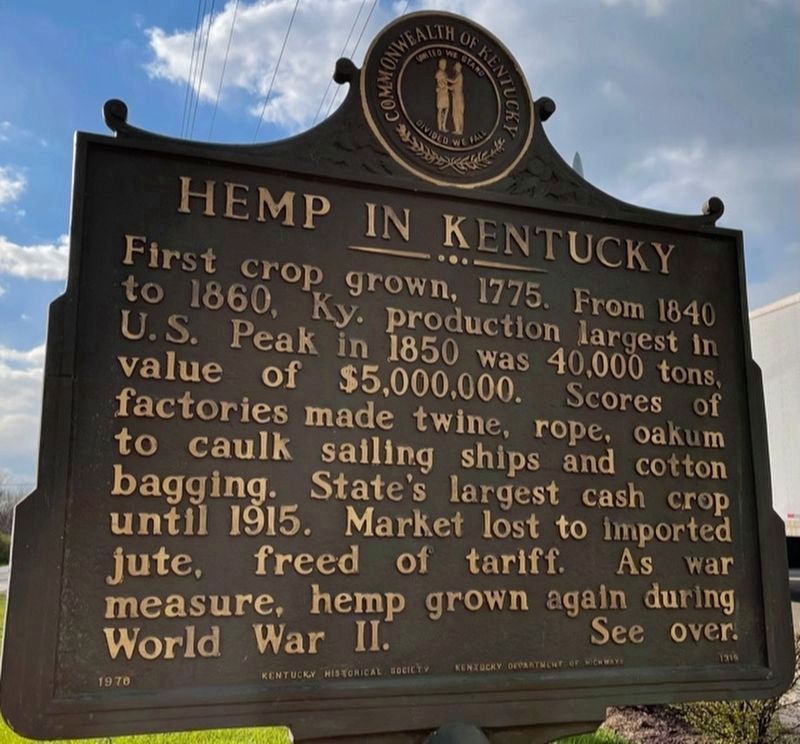
Hemp in Kentucky
First crop grown, 1775. From 1840 to 1860, Ky. production largest in U.S. Peak in 1850 was 40,000 tons, with value of $5,000,000. Scores of factories made twine, rope, gunny sacks, bags for cotton picking and marketing. . . . — — Map (db m83598) HM
Near Cardome Center South, 0.2 miles east of Cincinnati Pike (U.S. 25), on the right.
Hemp in Scott County Reverend Elijah Craig established at Georgetown, in 1789, one of the earliest ropewalks, which were long sheds for spiral winding of hemp fibers. Also started fulling mill in 1793. Both factories made cordage and rigging . . . — — Map (db m84825) HM
On Lexington Road (U.S. 60) at Paynes Mill Road, on the right when traveling west on Lexington Road.
Side One
Hemp in Kentucky:
First crop grown 1775. From 1840 to 1860, Ky. Production largest in U.S. Peak in 1850 was 40,000 tons, value of $5,000,000. Scores of factories made twine, rope, gunny sacks, bags for cotton picking and . . . — — Map (db m31133) HM
Near Meadow Road Northeast, 0.1 miles east of Eagle Nest Road Northeast, on the left when traveling west.
Native Americans used the stalk for fiber in the same way Europeans used their hemp plant, Cannabis sativa. Indian Hemp is superior, however, because it is stronger and lasts longer.
This herb is poisonous. — — Map (db m144567) HM
On Main Street (Business U.S. 68) at 9th Street, on the right when traveling north on Main Street.
Alexander House
The federal style house was built for William W. Alexander, a state representative 1848-52. His father, William Alexander, owned a hemp factory until 1856, which was operated by 100 enslaved people. At 600 feet, it had one of . . . — — Map (db m170055) HM
On West Main Street at North 4th Street, on the right when traveling west on West Main Street.
Kentucky's first recorded hemp crop, 1775, was on Clark's Run Creek, near Danville. Grown by Archibald McNeill, who brought the first seed with him when he located here. Hemp production spread slowly throughout the area, but Boyle County later . . . — — Map (db m121560) HM
Throughout the nineteenth century, Kentucky led the nation in hemp production. By the 1830s, Farmington was 550-acre working hemp plantation - a center of agriculture and industry. Hemp, the most labor-intensive crop grown in the state, perpetuated . . . — — Map (db m244654) HM
The Boonslick region has influenced Missouri history far out of proportion to its size. The rich land is an ecological intersection, where eastern forest and the Ozark Mountains meet prairie, and a large, navigable river runs through the middle. . . . — — Map (db m247352) HM
In early fall of 1841, thirty-two-year-old Abraham Lincoln, then a lawyer in Springfield, Illinois, visited his friend Joshua Speed at Farmington. Lincoln stayed here for a three-week period. At the time, both he and Speed were second-guessing their . . . — — Map (db m162004) HM
Panel 1 Jefferson introduced mechanized cloth production to his plantation when trade embargoes and looming war cut off the supply of imported British cloth. In 1811, he hired William McLure, a free white artisan and "a very ingenious man," . . . — — Map (db m68175) HM
On U.S. 421 at Fair Oaks Lane (a.k.a. : Great Buffalo Trace), on the right when traveling south on U.S. 421.
In 1773 McAfee Company and Hancock Taylor came here and surveyed area, an early pioneer stopping place. By 1775 Leestown settled and named by Hancock and Willis Lee; established by Va. Assembly, 1776. Temporarily abandoned in 1777 because of . . . — — Map (db m22153) HM
On West Park Avenue, on the right when traveling west.
Born in Kentucky. Came to Texas 1849. Civic and political leader. Represented Navarro County in Legislature, 1859-60. Joined in call for State Secession Convention, 1861. Joined 3rd Texas Cavalry. Later a colonel in 10th Texas Infantry. Wounded in . . . — — Map (db m60954) HM
In the 19th century travel by roads was slow and treacherous and railroads had not yet been established. Canal travel, for passengers and cargo, was a dependable means of transportation; canal boats helped to link Pennsylvania's major cities and . . . — — Map (db m120818) HM
On Walker Street at Shady Street, on the right when traveling south on Walker Street.
[Top Row - Left to Right:]
Many more than 200 years ago, Montgomery's history began along a hard bend of
the Alabama River in south central Alabama. Long before it was the capital, indeed
before the founding of the country, the area was home . . . — — Map (db m244537) HM
On North Railroad Street at Library Place, on the right when traveling south on North Railroad Street.
Aided and empowered by the opening of railroad tracks and the Hanover depot in 1852, the Hanover Commons reached peak industrial activity from the late 19th century well into the 20th, when the following businesses hummed and ticked: Hanover Train . . . — — Map (db m197102) HM
On East Broad Street near East Bay Street, on the left when traveling south.
On this site
During the 1730's the Trustees of the Georgia Colony, aided by funds from the Worshipful Society Of Apothecaries of London sought to grow New World medical plants both for their therapeutic value and for the enrichment of empire. The . . . — — Map (db m6185) HM
On Overseas Highway (U.S. 1 at milepost 77), on the left when traveling south.
Indian Key, an 11 acre island just offshore to the east, played an important part in Florida's history. An Indian village 1500 years ago, it was also the home of pirates roaming the Caribbean, and a ship wrecker's village during the 1810's. The . . . — — Map (db m176361) HM
On South Riverside Drive at Hamilton Road, on the right when traveling north on South Riverside Drive.
The Gabordy Canal, also known as the South Canal, was built by colonists brought to the New Smyrna area in 1768 by the Scottish physician, Dr. Andrew Turnbull. As part of the largest single attempt at British colonization, New Smyrna attracted more . . . — — Map (db m101768) HM
On State Road 44 at South Walker Drive, on the right when traveling east on State Road 44.
The Turnbull Grand Canal, also known as the Grand Canal, was built by indentured servants brought to the area by Scottish physician Dr. Andrew Turnbull in 1768. As part pf the largest single attempt at British colonization in North America, Smyrnea . . . — — Map (db m131383) HM
On North Upper Street near West Main Street (Route 25 / 60), on the right when traveling south. Reported permanently removed.
(Front): Known as the "Thunderbolt of the Confederacy," Morgan was born in Huntsville, Alabama; in 1831 moved to Lexington. After attending Transylvania, he fought in the Mexican war. In Lexington, he prospered as owner of hemp factory and . . . — — Map (db m166076) HM
Near East McDonald Parkway, 0.1 miles west of Limestone Street.
This county seat and trade center of over 4,500 people daily welcomed freight-hauling steamboats bringing in goods and visitors and picking up hemp, tobacco and whiskey at the bustling foot of Sutton Street. Senator Henry Clay and others stopped . . . — — Map (db m83974) HM
From the deck you see several important shallow water plants. Most visible is the broad leaved cattail with its brown, cigar-like top. In the spring, there is a yellow top above the brown. The thin, tall native plant with the pinkish-purple flowers . . . — — Map (db m79222)
Near Old Missouri 210, 0.5 miles east of Missouri Hiway 291.
The Liberty Landing, also known as Baxter’s Landing, located at the base of the bluffs one half mile west of Missouri 291 Highway, played a significant role in the history and development of Liberty, Missouri as well as Clay County. In use from 1829 . . . — — Map (db m46604) HM
Near Delaware Street, 0.1 miles north of Delaware Street and John Shea Drive.
Following victories in southwestern Missouri, Maj. Gen. Sterling Price and 10,000 men of the Missouri State Guard marched north with the objective of breaking the Federal line along the Missouri river. On Sept. 12, 1861 the Guard engaged and drove a . . . — — Map (db m46105) HM
On Main Street at West Commercial Street, on the left when traveling north on Main Street.
Waverly, noted for fine apples & rich farmlands was settled in 1818, chartered in 1850 with William Smith Thomas as Mayor. In 1804 Lewis & Clark Expedition made oars near Port of Waverly which served Missouri River steamboats and now barge lines for . . . — — Map (db m90359) HM
Thomas Tootle and Richard Leach formed a partnership, operating with various other partners in mercantile stores in Denver, Kansas City, here in Virginia City, and later in Deer Lodge. Tootle and Leach was one of Virginia City’s first businesses, . . . — — Map (db m209175) HM
On 8th Avenue at 3rd Street, on the right when traveling west on 8th Avenue.
When Cavalier County was being settled in the 1880s, spring wheat and durum were the primary crops. Other crops produced were barley, flax, and oats. Major changes in farming operations took place in the 1910s. On-farm grain storage became . . . — — Map (db m214097) HM
“Notice is hereby given to the Public, that the new oil Mill at Bethlehem for rubbing Hemp will be a going before Christmas. But the new Oil Mill will not be finished till the Latter end of Januario or in Febr. next year 1766...”
Oil . . . — — Map (db m27080) HM
On North Waddill Street north of West Erwin Avenue, on the right when traveling north.
A native of Virginia, James S. Muse (1804-1878) prospered as a hemp grower in Missouri before coming to Texas with his wife Margaret Slaughter. He bought 320 acres and built this house in 1858-1859. In one wing which was later removed, he opened . . . — — Map (db m163500) HM
Near Lehigh Gorge Trail, 2.2 miles west of Main Street when traveling north.
"Built in 1850, the (inclined) planes were 1,200 feet long and 430 feet high. As a loaded car descended on one plane. it would draw an empty car up the other plane."
John Koehler, Railroad Historian, Weatherly
You are . . . — — Map (db m114632) HM
These millstones stand in silent testimony to the importance of milling in Lancaster County. The first mill was built only a few years after the Mennonites arrived in 1710. Vital to agriculture, the mills increased in number to over 200 by 1839. . . . — — Map (db m160434) HM
Pinnacles has seen the birth and growth of modern rock climbing over the past 80 years. The early accents of the rock spires, often done with basketball sneakers and braided hemp rope, were dangerous and intensely challenging. The crackless faces of . . . — — Map (db m87694) HM
On North Riverside Drive at Julia Street, on the left when traveling north on North Riverside Drive.
During Florida's British Colonial period, 1763-1783, Doctor Andrew Turnbull established the largest North American colony at this site. Approximately 1300 Minorcans, Greeks, and Italians comprised the colony named after Smyrna, Asia Minor, the . . . — — Map (db m72962) HM
At this site was located the first public agricultural experimental garden in America. From this garden was disseminated the upland cotton which later comprised the greater part of the world`s cotton commerce. Here were propagated and from this . . . — — Map (db m18761) HM
On Sycamore Road north of Fincastle Road, on the right when traveling north.
From the time Henry Clay bought his first 125 acres in 1804 until long after his death in 1852, Ashland was an important and successful farm. It produced some of the finest livestock and crops in Kentucky and the nation. Ashland remained a center . . . — — Map (db m169736) HM
On Bardstown Road (U.S. 31E) at Wendell Avenue, on the right when traveling north on Bardstown Road.
Historic residence completed 1816 for John and Lucy (Fry) Speed. The Jefferson-inspired plan by Paul Skidmore includes octagonal rooms, rare in 19th c. Kentucky. As many as 64 African Americans enslaved at Farmington worked the 550-acre hemp . . . — — Map (db m162002) HM
Near Battlefield Memorial Highway (U.S. 421), on the right when traveling south.
Never a plantation Pleasant View Farm had its beginnings in 1801 when Joseph Barnett bought 578 acres on the Hayes Fork of Silver Creek. By 1824 he had constructed the brick house that stands today. About the same time, Barnett is believed . . . — — Map (db m31624) HM
On Main Street at Short Street, on the left when traveling south on Main Street.
Panel 1
1837 Weston is established by Joseph Moore taking a land claim and building the first cabin at present intersection of Market and Main
1837 Salem Christian Church is founded. Building constructed in 1841
1838 . . . — — Map (db m77143) HM
On Broadway (Pennsylvania Route 194) 0 miles north of Allewalt Avenue, on the left when traveling north. Reported permanently removed.
The original Moul Townhouse stood to your right. It was the mirror image of the 215 Broadway townhouse behind you. By 1915, the Moul Family replaced it with the Neoclassical Revival style brick home designed by Dempwolf Architects of York, which you . . . — — Map (db m22416) HM
Andrew Jackson called it his farm, but in reality, The Hermitage was a large cotton plantation dependent upon enslaved labor. All the agricultural activities on Jackson’s 1000 – acre plantation supported his cotton. On average, Jackson’s . . . — — Map (db m81422) HM
On Virginia Street (Virginia Route 602) 0.1 miles east of Cross Street (Route 227), on the right when traveling east.
Right in front of you is one of the oldest roads in America, Prettyman's Rolling Road descends to the waterfront at the end of Virginia Street. The early economy of Virginia was built from the growing and selling of tobacco. Urbanna Creek . . . — — Map (db m186723) HM
Near Wood Street, 0.1 miles north of 13th Street and Wood Street.
This area saw action between the Missouri Home Guard units and the Missouri State Guard. The Home Guard were composed of pro-Union German immigrants from Lafayette county. They were commanded by Maj. F.W. Becker. Sharpshooters kept many of the . . . — — Map (db m46167) HM
On Calle del Carmen north of Paso del Redín, on the right when traveling north.
Hasta los años 60 del s. XX las murallas eran el lugar ideal para el trabajo de los cordeleros. Gracias al espacio alargado que las paredes dibujaban, aquí trabajaban hebras de esparo y de cañamos, con ruedas y poleas . . . — — Map (db m233471) HM
On Green Street at Starr Street, on the left when traveling east on Green Street.
Starr Street is a brilliant preservation success story, a triumph of urban renewal without destruction. In the 1970s, with some houses already abandoned, the block was slated for demolition. In a risky, far-sighted move, the Savings Bank of New . . . — — Map (db m217031) HM
Near R Street Northwest at Avon Place Northwest, on the left when traveling east.
Here the Richard Parrott Ropewalk manufactured rope and rigging used on sailing vessels that plied their trade in old Georgetown through the early 19th Century.
The ropewalk receives its name from the long path used for the laying out of . . . — — Map (db m68712) HM
Near West North Washington Street at North Charles Street, on the right when traveling east.
Weaving for the Canal Homestead
If the woodsman's axe and the long rifle were first
in importance to the pioneer, the spinning wheel
and the loom would rank second. In colonial
America many families wove cloth for clothing.
bedding, . . . — — Map (db m163324) HM
On Broadway (Pennsylvania Route 194) just north of Locust Street, on the right when traveling north.
You are facing the Moul family mansion. A block behind it is the Conrad Moul iron foundry and saw and planing mill, first established in 1842, with the brick building before you erected in 1888. The Moul businesses were a mainstay of the Public . . . — — Map (db m197075) HM
On U.S. 212, 1.2 miles north of Old U.S. Highway 212, on the right when traveling east.
The Naca' Monument is a memorial to the families of the Cheyenne River Sioux Tribe that once lived along the river. It is placed along the Missouri River above the site of the town of Old Agency, which was located on the west shore of the river just . . . — — Map (db m246493) HM
History of the Matchlock Arquebus The matchlock arquebus first appeared in Europe in the mid-1400s. The name is taken from its ignition source, a slow, hot-burning cotton or hemp rope called a matchcord, or simply slow match. The . . . — — Map (db m189000) HM
On Old Frankfort Pike, on the left when traveling east.
Corn was the staple crop on most farms, because the grain fed people and livestock
throughout the year. After corn came wheat, rye, flax, hemp, barley, oats, turnips and potatoes. The kitchen
garden yielded vegetables and herbs.
The farm . . . — — Map (db m194472) HM
Working Waterfront-Standing here during the heyday of whaling you would have seen and heard the bustling of a whaling port preparing for sea: ship carpenters building vessels from great white oak timbers, and caulkers hammering oakum---hemp mixed . . . — — Map (db m62410) HM
Near Atlantic Avenue south of Commercial Street, on the right when traveling north.
Boston's legendary clipper ship trade centered around Lewis Wharf. Ships bound for faraway ports sailed from here in the 1840s and '50s:
• to buy tea in China and sell it in Europe.
• to California where most of the '49ers' famous gold . . . — — Map (db m115279) HM
On 1st Street (State Highway 5/240) at Market Street, on the left when traveling north on 1st Street.
Glasgow, site of first all steel bridge in world, built by Gen. Wm. S. Smith, Engr. 1879 for C. & A.R.R. Replaced 1900 for heavier traffic. Sketch of original bridge above. Glasgow founded 1836. Successor to Old Chariton 1817, Monticello 1829, . . . — — Map (db m217000) HM
On Delaware Street, 0.2 miles north of Delaware Street and John Shea Drive.
William Oliver Anderson (1794-1873) and his son-in-law, Henry Howard Gratz, had built a prosperous business in Lexington around hemp production and rope making in the 1850’s. Prior to the Civil War, Anderson became one of the most prominent . . . — — Map (db m46109) HM
On 1st Street (Missouri Route 9) at East Street (Missouri Route 9), in the median on 1st Street. Reported permanently removed.
Founded by George S. Park - 1838
First known as English Landing, river port on frontier, steamboat landing; slave, tobacco, and hemp market.
Home of Park College
Founded 1875
John A. McAfee and George S. Park
pioneered in new . . . — — Map (db m65993) HM
You are standing on the Arrow Rock bluff, where the Missouri River formerly made a bend. For generations, the Missouri River served as the great water highway of the West.
The Arrow Rock bluff was a significant landmark for American Indians, . . . — — Map (db m246859) HM
One of the iron and steel products for which Trenton became best known was wire rope. Originally developed as a stronger and more durable alternative to hemp, wire rope was first successfully produced in America in the early 1840s by John A. . . . — — Map (db m166126) HM
On Railroad Street at Courtright Street (Ohio Route 195), on the left when traveling east on Railroad Street.
Side A: Village of McGuffey
The Village of McGuffey was named for John McGuffey, who in the 1860s first attempted to drain the Scioto Marsh. A larger and more effective drainage effort, made by others who entered Hardin County in the 1880s, . . . — — Map (db m29062) HM
On East River Street, on the left when traveling east.
On January 18,1733, the British galley Anne arrived in Charleston, South Carolina with James Oglethorpe, 144 "sober, moral, and industrious" colonists and provisions to build a new colony south of the Savannah River in Georgia. While the . . . — — Map (db m19545) HM
On Old Lebanon Road (Kentucky Route 289) at Pleasant Hill Church Road, on the right when traveling north on Old Lebanon Road.
September 1861
Morgan caught smuggling Confederate uniforms
After Confederate forces occupied Columbus, a city in far western Kentucky, President Lincoln proclaimed that commercial trade with the Confederacy be stopped. . . . — — Map (db m99322) HM
Colonial Tobacco Trade Before you stands a crop of tobacco planted to reflect the historic tobacco trade that flourished at Mount Harmon in the colonial era. Tobacco was an important cash crop that helped build early American settlements, and . . . — — Map (db m156568) HM
Near Annapolis Road (Maryland Route 450) at 46th Street.
One of the maritime industries that was present in the colonial port of Bladensburg was the making of rope and various other types of cordage. In colonial and nineteenth century America, this activity took place in a manufacturing facility known as . . . — — Map (db m8222) HM
On 11th Street at Main Street, on the left when traveling north on 11th Street.
Side 1 Lexington, on the bluffs above the broad Missouri, grew up around Jack's Ferry, 1819, to become by 1860 one of the great river ports of the State. Prosperous river trade and agricultural richness of the area made the town a commercial . . . — — Map (db m90423) HM
On Burro Avenue, on the right when traveling east.
Raising thousands of pounds of rock from the depths of the earth required a massive headframe, strong engines and powerful cables to make it all work. The Mizpah had one of the earliest steel headframes. It weighed about 60,000 pounds and could . . . — — Map (db m188116) HM
(Preface): The Carolinas Campaign began of February 1, 1865, when Union Gen. William T. Sherman led his army north from Savannah, Georgia, after the March to the Sea. Sherman's objective was to join Gen. Ulysses S. Grant in Virginia to crush . . . — — Map (db m42335) HM
On 2nd Street west of Laurel Avenue, on the right when traveling west.
Steam donkeys such as this "Tacoma Wide Face Yarder" were a vital part of a logging team's equipment in the 19th century forests of Oregon. Their name is derived from secondary engines called "donkey engines" used on sailing ships to load cargo, . . . — — Map (db m113295) HM
In front of you is the site of Inclined Plane No. 6, one of ten inclines on the Allegheny Portage Railroad. The track visible today has been reconstructed.
From 1834 to 1854, railroad cars bearing canal boats, freight, and passengers were pulled . . . — — Map (db m53782) HM
On Chickies Hill Road south of Cedar Terrace, on the right when traveling north.
Sawneytown
Sawneytown was the free African community in Columbia. Per the History of Lancaster County (published in 1883) written by Franklin Ellis and Samuel Evans, in 1813 Robert Magill laid out lots on Filbert Street (present day Union . . . — — Map (db m241490) HM
On Main Street at Old York Road, on the left when traveling north on Main Street.
“They have carried the mechanical Arts to greater Perfection here than in any Place which I have seen.”
John Adams to Abigail Adams
April, 1777
Early Industrial History
By 1745, only four years after they founded . . . — — Map (db m26917) HM
First Steamboats
Early steamboat trips on the Missouri River tested boats, crews and passengers. Between 1820 and 1900, several hundred steamboats on the Missouri were destroyed by fire or boiler explosions, crushed by ice, or sunk by snags. . . . — — Map (db m46353) HM
On Katy Road (County Road 391) 0.6 miles north of Oilwell Road, on the right when traveling north.
Cole County, Missouri
Established November 16, 1820
Dedicated in this bicentennial year to those who have given life to Cole County, from the generations of Ancient Ones before the settlers of European and African lineage who formed our . . . — — Map (db m169397) HM
On Franklin Street at Water Street, on the left when traveling west on Franklin Street.
[Front]
"Come, drink, all who thirst for freedom: The water fountain will no longer separate us as a people."
During the Civil War era, one of every four Clay County residents was of African descent. Although sold in slave auctions and . . . — — Map (db m68207) HM
On Interstate 29, on the right when traveling south.
[Front]
Platte is one of 6 counties formed from the U.S. Government's 1836 Platte Purchase in which Iowa, Sac, Fox, and small bands of other Indian tribes gave up over 2 million acres of land for $7,500 and other benefits. The Purchase was . . . — — Map (db m66465) HM
On Northwest Lancaster County River Trail south of Furnace Road, on the left when traveling south.
In 1828, Henry Haldeman, patriarch of a well-to-do local family, purchased mills (including a saw mill, chopping mill, and a hemp mill) at the mouth of Chiques Creek and set up two of his sons in business there. The eldest son, Samuel, drew up . . . — — Map (db m136311) HM
On Sophia Street, 0.1 miles south of Frederick Street, on the left when traveling south.
Virginia Fredericksburg
Augt 25th 1773
Messrs. Samuel &William Vernon
Gentlemen
You will by this opportunity be advised by Capt. Jno. Duncan of his Arrival here, & valuing himself on Col. John Thornton for his Services in disposal . . . — — Map (db m97371) HM
Near Marina Way at Maritime Avenue, on the left when traveling south.
There would be approximately 12 miles of rope on board an average frigate of the Napoleonic era.
The Standing Rigging supports the masts. It is very thick as it has to bear a great deal of weight. These ropes could be as large as 10cm . . . — — Map (db m125685) HM
Constructed in 1897, the lower powerhouse
is designed to produce additional electricity
during periods of drought. Due to the
25-foot drop from the main powerhouse to
the lower powerhouse, the same water could
be reutilized to generate an . . . — — Map (db m192735) HM
With the coming of the Gold Rush, the
landscape began to change rapidly. Access to
deep water made this an attractive location for
early maritime industries. The Tubbs Cordage
Company located to Potrero Point in the
mid-1850s and built a 1,000 . . . — — Map (db m159589) HM
On West Fifth Street at North H Street, on the right when traveling west on West Fifth Street.
In memory of our men & women in the Armed Forces
World War II
First Column :
Elmer L. Alcorn • Frederick V. Alcorn • Lamoine T. Alcorn • Robert H. Allison • George Anderson • Marvin E. Anderson • Ernest Attebury • Floyd Bailey • . . . — — Map (db m11317) WM
On Missouri Route 41 at Visitors Center Drive, on the left when traveling north on State Route 41.
The Lawless House
D Lawless and his wife Martha Anne Dawson Lawless built this Queen Anne style farmhouse in 1903. They had been raising their family of eleven girls and one son in the log home of his father, Burton Lawless, just south of . . . — — Map (db m246748) HM
The 1860 census shows 15,000 people living in Saline county, 5,000 of whom were enslaved African Americans. The collapse of the hemp market and emancipation in 1865 resulted in many African Americans leaving farms and plantations. Many "freedmen" . . . — — Map (db m247019) HM
On East Water Street east of Court Street, on the right when traveling east.
Granite Monument erected September 17, 2017, Honors
Hugh Williamson, son of Scotch-Irish parents, was born 1735. in Nottingham, Pennsylvania. His parents wanted him to become a Presbyterian minister, but his quest for knowledge took him in . . . — — Map (db m225261) HM
"It turned out that a traveling carnival had set up there several years earlier and then didn't make enough money to pay the rent for the pasture. So they just left their 24-horse Carousel there. We got those hobby horses for a very reasonable . . . — — Map (db m177280) HM
In 1833, Josiah Davis constructed a narrow, 400-yard-long building where rope was manufactured for ship's rigging, a once-thriving maritime industry for the nearby port of Alexandria.
[Caption:]
The Jones Point ropewalk was a two-story . . . — — Map (db m127774) HM
On Correo at Cuna de Allende, on the right when traveling east on Correo.
Parroquia de San Miguel Arcángel Algunos años después de haberse fundado la antigua San Miguel el Grande (1555), se instauró en el lugar, uno de los primeros curatos de la región, entre los años dde 1563 y 1564. Tiempo en que . . . — — Map (db m131615) HM
On Church Street at Old Main Street, on the right when traveling north on Church Street.
The first farmers in this area were the Indigenous people who lived along the Connecticut River. Artifacts from this first farming community were uncovered at the Morgan Trench archaeological dig in the rock Hill Great Meadows. Surface finds, . . . — — Map (db m230804) HM
On Main Street at Court Street, on the right when traveling north on Main Street.
Middletown entered its golden era during the 1700s. By 1750, a century after its settlement, Middletown was the most populous and one of the richest towns in Connecticut.
The town owed its size and prosperity primarily to maritime trade. At . . . — — Map (db m98586) HM
Near First Street near Lucas Street, on the right when traveling north.
Once a place where Native American Indians hunted and fished, this peninsular part of Iowa is located where the Des Moines River flows into the Mississippi River.
Under French and Spanish rule for almost 150 nears, Southeast Iowa was included in . . . — — Map (db m179974) HM
1790
Indians Along the Missouri
The Missouri River served as a boundary between Indian tribes in historic times. The Osage dominated a vast area south of the river. To the north, the loway, and later Sauk and Fox, held power. . . . — — Map (db m247363) HM
The First Nations
Native peoples have lived around the Chignecto Isthmus for thousands of years. Travelling in family groups and small nomadic bands, they moved from area to area harvesting seasonal food sources.
Early French explorers . . . — — Map (db m112112) HM
On F Street Northwest at 7th Street Northwest, on the right when traveling west on F Street Northwest.
This tree has seen many changes.
Planted around 1905 on the grounds of what was then the U.S. Patent Office Building, it has slowly grown as the city has developed and transformed around it.
A rare, large, local specimen of a . . . — — Map (db m202449) HM
The General and Statesman
Isaac Shelby’s military decisions at the Battle of King’s Mountain in 1779 secured a critical victory for America during the Revolutionary War. Before war’s end, Shelby had also served in the North Carolina . . . — — Map (db m120217) HM
Near Derby Street, on the right when traveling east.
If you visited Salem’s waterfront in the late 1700s or early 1800s you would have been impressed not only by the ships and their exotic cargo, but also by the variety of artisans and craftsmen who worked on the wharf. Sail makers, riggers, rope . . . — — Map (db m220594) HM
1804...
Land Before the Town
Prior to its settlement, American Indians used the area we now call Rocheport. The closeness to the river, fertile soils, both salt and freshwater springs, and the protection given by the huge bluffs, rock . . . — — Map (db m46345) HM
Near Depot Street at 1st Street (State Highway D), on the left when traveling west.
1799
The Village of La Charrette
Long before Europeans settled in this area, Native American tribes including the Missouria, Osage, Sac and Fox used this land as their home or hunting grounds. The French, followed by the Spanish, were . . . — — Map (db m169262) HM
111 entries matched your criteria. The first 100 are listed above. The final 11 ⊳
* Inflectional forms of words are their plurals, singulars, and possessives as well as gramatical tenses and similar variations.