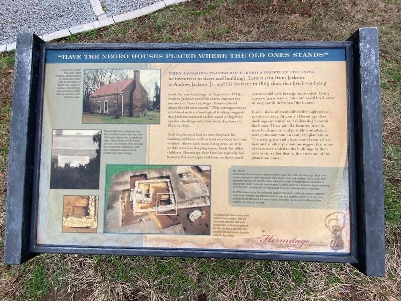
When Jackson's plantation turned a profit in the 1820s, he invested it in slaves and buildings. Letters sent from Jackson to Andrew Jackson Jr. and his overseer in 1829 show that brick was being made for new buildings. In September 1829, Andrew . . . — — Map (db m85383) HM
Near Rachels Lane, 0.3 miles east of Hermitage Road.
Rachel Jackson quietly suffered through Jackson’s bid for the White House, as his enemies attacked the circumstances of their marriage. Although Jackson easily won the presidency, Rachel dreaded the gossiping whispers of Washington’s social circles. . . . — — Map (db m81403) HM
Andrew Jackson arrived at the Hermitage in 1804 with nine slaves. By 1821, that number had risen to fifty. In 1823, Jackson brought another thirty enslaved African Americans here from his recently sold Alabama plantation.
Faced with pressing . . . — — Map (db m81405) HM
Near Rachels Lane, 0.3 miles east of Hermitage Road.
The idyllic planter’s life presented to white visitors by the Jackson family was based on the unpaid labor of over 150 enslaved black men, women, and children. Without the grueling labor of these individuals, the Jackson family could not have lived . . . — — Map (db m52407) HM
In the years after Andrew Jackson’s death, the Jackson’s financial situation changed for the worse. The log farmhouse/slave cabin slowly fell into ruin. In 1889, the state of Tennessee entrusted the property to the Ladies’ Hermitage Association. . . . — — Map (db m81406) HM
On Rachels Lane, 0.9 miles east of Hermitage Road when traveling east.
Of all the young men Andrew Jackson helped raise, perhaps none showed as much promise as Rachel's nephew Andrew Jackson Donelson. Donelson became Jackson's ward at age five when his father died.
Jackson saw to young Donelson's education, sending . . . — — Map (db m182555) HM
On Rachel's Lane, on the right when traveling west. Reported permanently removed.
Although no Civil War battles were fought here, the war touched Andrew Jackson's farm in other ways. Jackson had been a firm Unionist, putting down Nullification and its potential for civil war during his presidency. However, after his death, his . . . — — Map (db m214555) HM
On Lebanon Pike (U.S. 70) 0.1 miles west of Stones River, on the right when traveling west. Reported missing.
In 1780, the Gower party, tending Middle Tennessee's first cotton and corn crop, were killed or captured by Indians. On nearby Stone's River some flatboats were built for Aaron Burr's abortive expedition. The famous match races between Andrew . . . — — Map (db m147672) HM
In spite of the threat of violence, the men, women, and children who Andrew Jackson held in bondage still found ways to fight against the injustice and inhumanity of slavery. There were several instances of slaves running away. Jackson family . . . — — Map (db m85475) HM
Near Rachels Lane, 0.3 miles east of Hermitage Road.
From this point, you have many tour options inviting you to think about another time here at this 1120–acre National Historic Landmark. Use the map to guide you to any of the many points of interest you’ll find throughout Andrew Jackson’s . . . — — Map (db m85369) HM
Andrew Jackson built a cotton gin and press at The Hermitage in 1807, both of which stood in the field in front of you. It was a shrewd decision on Jackson's part, not only making his plantation more self-sufficient, but also generating additional . . . — — Map (db m85479) HM
Andrew Jackson called it his farm, but in reality, The Hermitage was a large cotton plantation dependent upon enslaved labor. All the agricultural activities on Jackson’s 1000 – acre plantation supported his cotton. On average, Jackson’s . . . — — Map (db m81422) HM
On Lebanon Pike (U.S. 70) at Shute Lane, on the right when traveling east on Lebanon Pike.
On Cumberland River, two miles north, was Andrew Jackson's plantation, Hunter's Hill, which he bought in 1796 and where he lived until 1804 when he sold it to Colonel Edward Ward and removed to the adjoining tract to which he gave the name of the . . . — — Map (db m147681) HM
Near Rachels Lane, 0.3 miles east of Hermitage Road.
For the Jackson family, the enslaved were property and the foundation of their wealth. The monetary value of the enslaved far exceeded the combined worth of the Hermitage land, mansion and other improvements.
Andrew Jackson himself had no . . . — — Map (db m52412) HM
Near Lebanon Pike (U.S. 70) near Stones River Greenway, on the right when traveling west.
Stone Hall and the cabin Eversong on the Stones River are situated on land that
before white settlers came was Native American Indian hunting grounds controlled
primarily by the Cherokee, but also used by the Shawnee and Chickasaw. . . . — — Map (db m147665) HM
Artifacts found during excavations of the Field Quarter have much to say about daily life within the Hermitage enslaved community. Animal bones tell us a great deal about diet. Buttons and sewing equipment provide details about clothing. Marbles, . . . — — Map (db m85445) HM
Near Rachels Lane, 0.3 miles east of Hermitage Road.
These log buildings tell a remarkable American story unlike any other. From 1804 to 1821, as a two-story farmhouse and kitchen outbuilding, the First Hermitage housed future United States President Andrew Jackson and his family. Here, Jackson lived . . . — — Map (db m52420) HM
This small brick privy or necessary is something of a mystery. No documents or illustrations record the presence of such a building when the Jackson family lived on the property. Archaelogical evidence suggests that an older building may have stood . . . — — Map (db m85374) HM
Home of Andrew Jackson (1767~1845), Major General in the Army, hero of the Battle of New Orleans, and seventh President of the United States. It was originally built in 1819; partially burned in 1834, during Jackson's second term, replaced by the . . . — — Map (db m36280) HM
Near Rachels Lane, 0.7 miles east of Hermitage Road, on the right when traveling east.
In 1823, Andrew Jackson donated the land, a portion of the funds, and the labor of his slaves to build this simple church. There's little doubt that it was the encouragement of Rachel Jackson, a devout Presbyterian, that prompted her husband's . . . — — Map (db m182525) HM
Near Rachels Lane, 0.3 miles east of Hermitage Road.
As with all living things, the Hermitage Garden cannot be wholly defined by any particular moment in time. Gardens grow and change. Few records tell us about the appearance of the garden Andrew Jackson enjoyed. Jackson hired gardener William Frost . . . — — Map (db m85370) HM
As was common at large plantations, Jackson hired a white overseer on an annual contract to supervise farm operations, particularly the lives and work of the enslaved. The overseer's contract began on January 1, after the previous year's crop had . . . — — Map (db m85477) HM
Near Rachels Lane, 0.3 miles east of Hermitage Road.
This log building was not part of Andrew Jackson’s Hermitage. In 1929, a fire destroyed one of Jackson’s original barns. To help replace it, The Ladies’ Hermitage Association purchased and moved this log building from the nearby Hunter's Hill . . . — — Map (db m52416) HM
Near Rachels Lane, 0.3 miles east of Hermitage Road.
Andrew Jackson's strong sense of family extended beyond those he embraced during his lifetime.
Reaching into the future to touch generations yet to come, he deeded a small portion of the garden in trust to serve as a family cemetery. Stones . . . — — Map (db m85372) HM
Near Rachels Lane, 0.7 miles Hermitage Road, on the right when traveling east.
At a time when America was growing in more than material ways, the Jacksons, too, were touched by matters spiritual. In the early 1800s, the stresses of a young nation on the move to new political, geographic, and economic areas produced rapid . . . — — Map (db m182530) HM
Near Rachels Lane, 0.3 miles east of Hermitage Road. Reported permanently removed.
In 1915, The Ladies' Hermitage Association planted this double line of trees to serve as the border for a new entryway intended for visitors arriving by automobile. Each tree came from a battlefield where Andrew Jackson fought, such as the Plain of . . . — — Map (db m214554) HM
Near Rachels Lane, 0.3 miles east of Hermitage Road.
The stately trees and park-like grounds of today’s Hermitage bear scant resemblance to the working plantation of Andrew Jackson’s time. As the farm developed, trees were cleared to make room for fields and pastures.
By the time the first . . . — — Map (db m52408) HM
On Rachels Lane, 0.9 miles east of Hermitage Road when traveling east.
In 1834, Andrew Jackson Donelson began plans for his eventual return to Tennessee when Jackson's presidency ended in 1837. Donelson chose to build a new home on his land adjoining The Hermitage. There he could be near Andrew Jackson, as he had been . . . — — Map (db m182561) HM
On Gallatin Pike North (U.S. 31E) at Rivergate Parkway, on the right when traveling south on Gallatin Pike North.
After Col. John Donelson was killed in 1785, his widow and family continued to live here in a log house. In 1789 lawyers Andrew Jackson and John Overton boarded with the Donelsons. Here Jackson met Rachel, the Donelson's youngest daughter. They . . . — — Map (db m147702) HM
Near Harding Pike (U.S. 70S) 0.2 miles north of Leake Avenue, on the right when traveling north.
In 1742 a European settler recorded his travel and the conditions of the path which was known as the Natchez Trace. This is the earliest known recording of the trace, a portion of which was located on the site of Belle Meade Plantation. The trace, . . . — — Map (db m81472) HM
Home of Mary Benton, widow of Jesse Benton who left Nashville after a famous feud with Andrew Jackson in 1813. The Greek Revival house was built c. 1852 and stood between Union and Confederate lines during the Battle of Nashville in 1864. Prominent . . . — — Map (db m52851) HM
The first part of this house was built in 1799 by Judge John Overton, one time Revenue Collector for the Mero District of North Carolina, later member of the Tennessee Supreme Court and longtime friend of Andrew Jackson. These two with General James . . . — — Map (db m25652) HM
On Deaderick Street, on the right when traveling west.
Andrew and Rachel were both born in 1767 - Rachel. in the Virginia frontier and Andrew, in the Waxhaws region in South Carolina. Rachel traveled down the rivers on a flatboat with her family when they moved to Nashville in 1780. Andrew came to . . . — — Map (db m213216) HM
On 5th Ave N at Church St, on the right when traveling north on 5th Ave N.
From 1814 to 1955 this was the site of the First Presbyterian Church. President Andrew Jackson was received into the church in 1838. James K. Polk was inaugurated governor here in 1839. The building designed in the Egyptian style by William . . . — — Map (db m121842) HM
On Church Street, 0.1 miles west of 4th Avenue North, on the left when traveling east. Reported missing.
Across the alley stood the first Masonic Hall in the state, designed by architect Hugh Roland in 1818. Marquis de la Fayette was entertained there in 1825 by Past Grand Master Andrew Jackson. The 17th General Assembly of Tennessee met there in 1827. . . . — — Map (db m188945) HM
On Union Street, 0.1 miles east of 4th Avenue North, on the left when traveling west. Reported missing.
Andrew Jackson settled in Nashville in 1788 and served as Atty. Gen. until 1796. Lawyer John Overton owned a building here (1791-96) and shared office space with his friend Jackson. Jackson was Tennessee's first Rep. to Congress (1796) and state . . . — — Map (db m188936) HM
Andrew Jackson
Born March 15, 1767 - Died June 8, 1845
Grand Master of Tennessee 1822-1823
President of the United States 1829-1837 — — Map (db m214563) HM
On Rosa L. Parks Boulevard (Alternate U.S. 41) 0.2 miles Athens Way, on the right when traveling west.
Brick manufacturer and builder, who fought under General Andrew Jackson in the Creek campaigns and at the Battle of New Orleans, left at his death in 1880 property and $100,000 as an endowment for a school later called Watkins Institute, organized . . . — — Map (db m147768) HM
Born March 15, 1767 Died June 8, 1845
Seventh President of the United States 1829-1837
Commander of victorious American forces
at Battle of New Orleans January 8, 1815
This equestrian statue by Clark Mills was erected by the Tennessee . . . — — Map (db m85487) HM WM
On 7th Avenue North, on the left when traveling south.
In 1836, President Andrew Jackson declared the Treaty of New Echota binding, thereby mandating Cherokee emigrate by 1838 or be removed. — — Map (db m215447) HM
On Broadway at 8th Avenue South, on the right when traveling east on Broadway.
Also called The Commons, originally 240 acres extending south to the river. Given to Davidson Academy by the State of North Carolina, famous as a mustering ground. Here 4,000 Tennessee Militia were reviewed by Andrew Jackson and Lafayette on the . . . — — Map (db m84200) HM
On Donelson Avenue west of Bryan Street, on the left when traveling west.
Served in the Revolutionary War and as Inspector of Revenue in North Carolina, the same position held by his brother Judge John Overton in Tennessee. Close friend of Andrew Jackson, he was one of Jackson's seconds in the duel with Charles Dickinson. . . . — — Map (db m147696) HM
On Tennessee Route 26 at Tennessee Route 83, on the right when traveling east on State Route 26.
The Beckwith Inn was located just south of here on the Old Turnpike. Originally built by James Cannady in 1816, it was one of the best-known landmarks in DeKalb County. James B. and Rachel Roulstone Beckwith operated the inn from 1843 until the late . . . — — Map (db m84976) HM
On Blackburn Hollow Road east of Lewisburg Highway (U.S. 31A), on the left when traveling east.
Serving under Gen. Andrew Jackson as captain in the War of 1812, he became a lifelong friend of ailing Jackson in Creek War when he said to him, "General I'll stay, will die with you," as others threatened to leave. Pioneer settler of Brick Church, . . . — — Map (db m38827) HM
On Wood Street (U.S. 79) at North Poplar Street, on the right when traveling east on Wood Street.
(Front):
Henry County Courthouse
This Courthouse was designed by Reuben Harrison Hunt of Chattanooga and built by Ed M. Wallen of New Decatur, Alabama, in 1896. It is the third courthouse on this site and is one of West Tennessee's . . . — — Map (db m81947) HM
On Gladdice Highway (State Highway 85) at Smith Bend Lane, on the right when traveling east on Gladdice Highway. Reported missing.
Sampson Williams is regarded as the founding father of Jackson County and is considered its first citizen. In a 1789 engagement with the Indians in the Cumberland settlement, Andrew Jackson was under Captain Williams' command. Later, he and Jackson . . . — — Map (db m207600) HM
Samuel McSpadden, powdermaker and Revolutionary War veteran, built this house in 1804, and died here on August 3, 1844. From a crude powdermill located 1/4 mile north he sent flatboats loaded with gunpowder to New Orleans, where General Andrew . . . — — Map (db m80438) HM
On Jefferson Davis Highway (U.S. 51) south of Unionville Road / Old Hwy 20 (Tennessee Route 210), on the right when traveling north.
(obverse)
Dyer County
Established 1823; named in honor of
Colonel Robert Henry Dyer
who served valiantly under General Andrew Jackson in the Natchez Expedition, the Creek War, War of 1812, - including the decisive . . . — — Map (db m55946) HM
In the 49 years that David Crockett called Tennessee his home he migrated from one end of the Volunteer state to the other. From his birthplace near Limestone on the banks of the Nolichucky River to his last home in present day Rutherford (Gibson . . . — — Map (db m107422) HM
“Be always sure you are right, then go ahead!”
• Raised in frontier poverty without any education until he is a teenager, David is often hired out to others for additional income while still a child; once held against his will until . . . — — Map (db m108201) HM
On 2nd Avenue South at Mill Creek Drive, on the right when traveling west on 2nd Avenue South.
Glen's Stand was a large log house, inn, and tavern. Built pre-1812 by the Glen family in the Mississippi Territory, it was located on a trail beaten out by buffalos, which became part of (Cherokee Chief) Doublehead Trace. It stood at present-day . . . — — Map (db m146819) HM WM
On 2nd Avenue South at Millcreek Drive, on the right when traveling south on 2nd Avenue South.
An agreement was made with the Masons to build and share the two-story wood clapboard building. Different protestant denominations contributed labor, materials, and money. The graveyard, donated in 1908, became Loretto Cemetery after the church . . . — — Map (db m101814) HM
Near Natchez Trace Parkway (at milepost 385.9), 0.2 miles north of Summertown Highway (Tennessee Route 20).
This plainly visible, though long deserted road is a section of The Natchez Trace, evolved from Buffalo and Indian Trails, into The First National Highway of the South-West, cut and opened under authority of the United States Government, after . . . — — Map (db m42767) HM
Near Natchez Trace Parkway (at milepost 385.9), 0.2 miles north of Summertown Highway (Tennessee Route 20), on the left when traveling north.
The Natchez Trace, a very old trail, was traveled by many early Americans. Captain Meriwether Lewis, leader of the Lewis and Clark Expedition and governor of the Upper Louisiana Territory, died near this point in 1809 while traveling the Natchez . . . — — Map (db m84633) HM
For Love of Family and Country
Andrew Jackson lost his entire family-father, two brother,
and mother-before his 15th birthday. His character was
marked by an abiding hatred of the British inspired by his
experiences during the . . . — — Map (db m207973) HM
On Huntsville Highway (U.S. 231/431) 0.1 miles south of Wilson Parkway/Thornton Taylor Parkway (Bypass U.S. 64), on the right when traveling north.
Here in October, 1813, Maj. Gen. Andrew Jackson mobilized from the Tennessee militia a mounted brigade, an artillery company and an infantry division, about 3500 men, for punitive operations in Mississippi territory, now Alabama. Brig. Gen. John . . . — — Map (db m31813) HM
On Huntsville Highway (U.S. 231/431) 0.5 miles south of Wilson Parkway/Thornton Taylor Parkway (Bypass U.S. 64), on the right when traveling north.
In September 1813 the Army of West Tennessee assembled at Camp Blount on the Elk River just north and east of these oaks. On October 7th, Major General Andrew Jackson arrived in Fayetteville to take command of the army which, included Sam Houston . . . — — Map (db m158777) HM
Camp Blount was one of the earliest and by far the largest muster site for "Tennessee Volunteers during the War of 1812 and the Creek War, as such it helped Tennessee earn its official nickname, "The Volunteer State."
Between 1813 and 1815 . . . — — Map (db m207964) HM
Camp Blount was the rendezvous point and mustering ground for thousands of Tennessee militia serving under Gen. Andrew Jackson in the War of 1812 and the Creek War. The State of Tennessee has preserved this site as a memorial to Tennesseans who . . . — — Map (db m207926) HM
Massacre at Fort Mims
The Creek civil war boiled over on August 30, 1813, when
Red Stick Creeks attacked Fort Mims in present-day
Alabama. Most of those killed were Creeks or spouses
or children of Creeks who had accepted . . . — — Map (db m207969) HM
Tennesseans Push for War
The War of 1812 and Creek War thrust Tennessee into
the national spotlight. Tennessean Felix Grundy led the War Hawks, politicians who pushed the declaration of war against the British through Congress in June . . . — — Map (db m207965) HM
On Huntsville Highway (U.S. 231/431) 0.8 miles south of Ardmore Highway (State Road 110), on the right when traveling north.
Immediately to the east lies an old cemetery that was established at an early date along the Great Road to Twickingham, now Huntsville, Alabama, over which General Andrew Jackson and his volunteers marched in 1813 to the Creek War. Revolutionary . . . — — Map (db m30571) HM
A National Hero
Andrew Jackson's victories during the Creek War and the War of 1812 made him a national hero. A contemporary noted, "Only George Washington enjoyed a reputation of comparable
scope.” For decades, the
nation celebrated . . . — — Map (db m207966) HM
Black Raven
Soon after Sam Houston's father died, his mother moved
the family from Virginia to Maryville, Tennessee. Unhappy
with life on the farm, fourteen-year-old Sam ran away from
home to live with a Cherokee tribe. Black Raven, as . . . — — Map (db m207975) HM
The Business of War
Gov. Willie Blount's order calling out the militia brought
fifty-five year old Robert Hays, Andrew Jackson's
brother-in-law, back into service. Hays served as Muster
Master and Inspector at the rendevous site named . . . — — Map (db m207971) HM
The Creek Civil War
For years, the rift within the Creek Nation had grown
ever wider. Some Creeks accepted the federal government's program of acculturation. The Red Sticks did not. The growing tension between the two factions erupted into . . . — — Map (db m207963) HM
On Auditorium Street at East Chester Street (U.S. 70), on the left when traveling south on Auditorium Street.
William E. Butler, who served as Surgeon-General to Andrew Jackson in New Orleans, owned a race track located on this block. Jackson and his wife, Rachel Donelson Jackson, attended races here in 1825. In 1843 Dr. Butler donated the site for a school . . . — — Map (db m61153) HM
On South Royal Street, on the right when traveling south.
Here in a grove, Oct. 8, 1840, Andrew Jackson spoke before about 10,000 enthusiastic listeners. Accompanied by James K. Polk and Felix Grundy, he was honor guest at a barbecue. Veterans of the War of 1812, welcomed him upon his second visit. — — Map (db m51373) HM
Land donated by Richard "Kettle Dick" Anderson from 2,000 acre land grant he settled in 1810. Named "Old Well" for well at NW corner of cemetery dug by Andrew Jackson's army returning from the battle of New Orleans. Early settlers used the well as . . . — — Map (db m102063) HM
Near Natchez Trace Parkway (at milepost 407.7) south of Williamsport Pike (Tennessee Highway 50), on the right when traveling north. Reported missing.
The 500 mile long Natchez Trace of the early 1800's, then known as the Natchez Road, connected Nashville on the Cumberland River with Natchez on the Mississippi River. This historic wilderness road crossed the Duck River 1/4 mile south of here. John . . . — — Map (db m84260) HM
Near Natchez Trace Parkway (at milepost 407) south of Williamsport Pike (Tennessee Route 50), on the right when traveling north.
One of the few remaining buildings associated with the Old Natchez Trace is the house of ferry operator John Gordon.
In the early 1800s Gordon made an agreement with the Chickasaw Chief George Colbert to operate a trading post and ferry on the . . . — — Map (db m60217) HM
Near Blythe Ferry Road, 2 miles north of Hiwassee Highway (Tennessee Highway 60), on the right when traveling north.
Both the Indian Removal Act of 1830 and the Treaty of New Echota aimed to accomplish removal through voluntary emigration. Such efforts largely failed and by 1838 only about 2,000 Cherokee affected by the treaty had moved west. For those remaining, . . . — — Map (db m39493) HM
Near Blythe Ferry Road, 2 miles north of Hiwassee Highway (Tennessee Highway 60), on the right when traveling north.
Both the Indian Removal Act of 1830 and the Treaty of New Echota aimed to accomplish removal through voluntary emigration. Such efforts largely failed and by 1838 only about 2,000 Cherokee affected by the treaty had moved west. For those remaining, . . . — — Map (db m39529) HM
On State Highway 58, 1 mile south of Cameron Road, on the right when traveling south.
About 1 mile east, at the mouth of Agency Creek, the U.S. Agency for the Cherokees was located from 1816 to 1821. Here, on July 8. 1817, Maj. Gen. Andrew Jackson, Governor Joseph McMinn, and David Meriwether, U.S. Commissioners, concluded a treaty . . . — — Map (db m150444) HM
On Tennessee Route 68 at County Farm Road, on the right when traveling north on State Route 68.
This highway follows two miles of the Old Federal Road established by the Treaty of 1805 between the United States and the Cherokee Nation. The Road began at the Tellico Blockhouse on the Little Tennessee River and extended to Vann’s Ferry on the . . . — — Map (db m49576) HM
On County Route 41, 0.1 miles east of Keysburg Road (Highway 1884), on the right when traveling west.
To the north was the farm of John Bell, an early, prominent settler from North Carolina. According to legend, his family was harried during the early 19th century by the famous Bell Witch. She kept the household in turmoil, assaulted Bell, and drove . . . — — Map (db m50725) HM
A soldier of the colonial army of 1776, and a veteran of the American Revolution, 1776-1781, Thomas Atchley served alongside private Andrew Jackson in 1794 under the command of Brigadier General James Robertson in the Indian Wars of the lower . . . — — Map (db m17103) HM
As early as the 1730's, a few British traders lived among the Chickasaw in this area, but Great Britain's brief ascendancy on the Lower Mississippi did not began until 1763. In that year, the British defeated France in the Seven Years' War and took . . . — — Map (db m82852) HM
On Poplar Avenue (U.S. 72) east of Interstate 240, on the left when traveling east.
Shelby County Established 1819; named in honor of ISAAC SHELBY who, along with Andrew Jackson, was appointed United States Commissioner; together they arranged the purchase of the Western District from the Chickasaw Indian Nation . . . — — Map (db m82859) HM
Although eastern Tennessee was settled in the 1770's, Western Tennessee was still wilderness when the state was admitted to the Union in 1796. Fort Pickering, a trading post of the Fourth Chickasaw Bluff was located near present day Memphis. At the . . . — — Map (db m82862) HM
Near Island Drive, 0.8 miles south of West A.W. Willis Avenue when traveling south.
Mile 90.2 AHP
Word of the treaty signed in December 1814, was slow to reach the countryside south of New Orleans, LA. Before dawn on January 8, 1815, General Andrew Jackson’s American troops were waiting for a British attack. Commanded . . . — — Map (db m114922) HM
Near Island Drive, 0.8 miles south of West A.W. Willis Avenue when traveling south.
A) Venice Louisiana
Mile 10.8 AHP
Venice lies at the end of the longest continuous levee line in the world, stretching 650 miles north to the Arkansas River. It is the last town accessible by a highway on the west bank of the . . . — — Map (db m114915) HM
On Adams Avenue at Third Street, on the right when traveling west on Adams Avenue.
Exterior statuary at the Shelby County Courthouse includes, most prominently, six seated figures carved from single blocks of Tennessee marble, representing Wisdom, Justice, Liberty, Authority, Peace, and Prosperity. Near the top of the north facade . . . — — Map (db m82861) HM
On Bristol Highway (State Road 126) west of Anderson Road, on the right when traveling west.
Built shortly after 1785 by William Deery. Stopping place for many distinguished travelers of early days, Andrew Jackson, James K. Polk, the Marquis de Lafayette, Prince Louis Phillipe, Andrew Johnson and others enjoyed its hospitality. It operated . . . — — Map (db m82955) HM
On Carl Moore Parkway (U.S. 421) at Old Jonesboro Road, on the right when traveling east on Carl Moore Parkway.
It crosses the highway here. Originally a branch of the Great War and Trading Path, it was later an important route from Virginia to the west. The first mail route between Richmond and Washington ran over it. Many notables used it, including Andrew . . . — — Map (db m157952) HM
On Netherland Inn Road just east of Lilac Street, on the right when traveling west.
In 1802 William King of Saltville, Virginia purchased two lots in Christianville where he built a dwelling, wharfs, warehouses and a store.
In 1818 Richard Netherland, Esquire, purchased the property and established a tavern on the Great Stage . . . — — Map (db m158080) HM
On Bristol Highway (State Highway 34) near Hyder Hill Road.
300 yards to the southeast is the home of William Cobb, pioneer. First seat of government of the Southwest Territory, October 10, 1790: Governor William Blount had headquarters here till removal to Knoxville, the new capital, in 1792. Andrew Jackson . . . — — Map (db m22906) HM
On U.S. 231, 0.2 miles north of Chipman Road/Browning Branch Road (Tennessee Route 260), on the right when traveling south.
Sumner County
Established 1786; named in honor of
Major Gen. Jethro Sumner
Officer in French and Indian War. Served in defense of Charleston, 1776; in the Battles of Brandywine and Germantown; and in the Army at Valley Forge. His last . . . — — Map (db m149919) HM
On Hartsville Pike west of Harsh Lane, on the left when traveling west.
0.7 mile north, the home of James Winchester, built by artisans from his home state of Maryland and completed in 1802. He was a War of 1812 brigadier general, and in association with General Andrew Jackson and Judge John Overton was one of Memphis' . . . — — Map (db m82968) HM WM
On Ben Albert Road at Tyree Springs Road (Tennessee Route 258), on the right when traveling south on Ben Albert Road.
A mineral springs resort was established here by R.C. Tyree sometime between 1814 and 1822. By 1834 it was the most celebrated watering place in the state. Presidents Andrew Jackson and James K. Polk were guests here. Burned during the Civil War, . . . — — Map (db m151838) HM
In the valley 500 yards north were held many kinds of frontier diversions, including racing on a half~mile semicircular track. Here, in 1788, Andrew Jackson, then 21 years old, rode his horse in a match race against a horse belonging to Col. Robert . . . — — Map (db m82981) HM
On West Main Street (Old State Highway 34), on the right when traveling west.
This 1778 landmark was the home of
Captain Christopher Taylor
Revolutionary War officer and a State of Franklin leader
Andrew Jackson
Seventh President of the United States
Boarded here in 1788 while practicing law in Jonesborough . . . — — Map (db m158251) HM
Built in 1797 by Dr. William P. Chester of Lancaster, Pa., it has been continuously occupied as an Inn, a hotel and an apartment house. Among the guests here have been three presidents of the United States, Andrew Jackson, James K. Polk and Andrew . . . — — Map (db m22845) HM
About one mile southwest of this location,
this log house was built in 1777 by this
officer who was a veteran of the French
and Indian War and a major in the
American Revolutionary War. He is buried
in the family cemetery nearby. . . . — — Map (db m83137) HM
On Musket Lane, on the right when traveling south.
• Raised in frontier poverty without any education until he is a teenager, David is often hired out to others for additional income while still a child; once held against his will until he escapes under the cover of a winter storm. • To avoid . . . — — Map (db m58421) HM