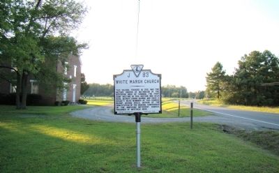
On Mary Ball Road (Virginia Route 3) just east of Pinckardsville Road (County Route 605), on the right when traveling east.
This church, founded in 1792, was the mother church of Methodism in the Northern Neck of Virginia. The first camp meeting in this section was held here. Bishops Enoch George and David S. Doggett were members of this church. Bishop Joshua Soule, . . . — — Map (db m24175) HM
On Mary Ball Road (Virginia Route 3) just west of River Road ( Route 354), on the left when traveling east.
Lancaster County. Area 130 square miles. Formed in 1652, and named for Lancaster, England. Ancient Christ Church and Epping Forest, birthplace of Washington’s Mother, are in this county.
Richmond County. Area 204 . . . — — Map (db m23607) HM
On Irvington Road (Virginia Route 200) at King Carter Drive, on the right when traveling south on Irvington Road.
To our departed comrades who served their country during the Great World War
Fred D. Mason
Died in Germany
Aug. 20, 1921
Robert H. Barker
Died in Service
Nov. 14, 1918
A separate bronze plaque reads:
Rebuilt in May 1988 . . . — — Map (db m39948) WM
On Jessie Dupont Memorial Highway (Virginia Route 200) just south of Ditchley Road (County Route 607), on the right when traveling north.
Ditchley, five miles northeast, was patented in 1651 by Colonel Richard Lee. The first house dated from 1687, the present house was built by Kendall Lee in 1752.
Cobbs Hall, near by, was acquired by Richard Lee, probably before 1651. A house . . . — — Map (db m24475) HM
On Mary Ball Road (Virginia Route 3) at Route 651, on the right when traveling south on Mary Ball Road.
Dr. Morgan E. Norris, a Lancaster native and the Northern Neck’s first black physician, practiced medicine at this site 1917-1964. He opened to all races specialty surgical clinics, bringing enhanced medical care to the lower Northern Neck. In 1928 . . . — — Map (db m97210) HM
On South Main Street (Virginia Route 3) at West Church Steet ( Route 200), on the left when traveling north on South Main Street.
Here was born, October 28, 1817, Henrietta Hall (daughter of Colonel Addison Hall), first American woman missionary to China. She married Rev. J. Lewis Shuck, and was sent with him to China by the Baptist Board of Foreign Missions, arriving there in . . . — — Map (db m24248) HM
Hughlett Point Natural Area Preserve is situated on a small peninsula on the western shore of the Chesapeake Bay. The preserve contains tidal and non-tidal wetlands, and exemplary undeveloped beach and low dunes, and upland forest communities. It is . . . — — Map (db m97241) HM
Near Balls Neck Road (Virginia Route 605) 1.1 miles south of Harding Wharf Drive ( Route 670), on the left when traveling south.
Well known for her contributions to this area of Virginia, Jessie Ball duPont (nee Jessie Dew Ball) was born on Ball family property about one mile north of Hughlett Point.
Schoolteacher
She was the first teacher at Shiloh School in . . . — — Map (db m97240) HM
On Main Street (Virginia Route 3) at East Church Street ( Route 200), on the right when traveling east on Main Street.
Kilmarnock was called “the Crossroads” about 1664, because multiple thoroughfares crossed here. By the middle of the 18th century, the community was named Steptoe’s Ordinary for a storehouse and tavern owned by William Steptoe I. About . . . — — Map (db m24218) HM
Near North Main Street (Virginia Route 3) just north of Cralle Street, on the right when traveling north.
This garden is a living tribute to all of America's veterans and their families. In silence and respect, this is a place to remember why millions of Americans have fought and died for our liberty and our freedom. Here we renew our promise to fulfill . . . — — Map (db m176061) WM
On Kamps Mill Road north of American Drive, on the right when traveling north.
Armistead Nickens was born into a family of free people of color that included at least 12 veterans of the Revolutionary War. In 1867 the local agent of the Freedmen's Bureau identified him as a strong potential candidate for public office. After . . . — — Map (db m309476) HM
On Merry Point Road, on the left when traveling south.
Located one mile south on land lying between the eastern and western branches of the Corotoman River. It is the site of Barford, the dwelling of Captain Thomas Carter who was living there by 1674. A gift from his father-in-law, Edward Dale, the . . . — — Map (db m130231) HM
On Mary Ball Road (Virginia Route 3) just east of Morattico Road (County Route 622), on the right.
Seven tenths mile west is Epping Forest. The land was patented by Colonel Joseph Ball, who died there in 1711. His daughter, Mary Ball, mother of George Washington, was born there in 1707/8. The house incorporates parts of the original structure. — — Map (db m23764) HM
On Devils Bottom Road south of Mary Ball Road ( Route 3), on the right when traveling south.
Lancaster Co. opened Brookvale High School to serve Black students in 1959, five years after the U.S. Supreme Court declared public school segregation unconstitutional. The building replaced the old A.T. Wright High School. The Crusaders . . . — — Map (db m309478) HM
On River Road (Virginia Route 354) at White Chapel Road ( Route 201), on the left when traveling north on River Road.
Welcome to St. Mary’s Whitechapel Episcopal Church.
By the time of the American Revolution, this church had already served its parish of Virginia colonists for over a century. The parish was founded under the supervision of the House of . . . — — Map (db m23821) HM
Near Belle Isle Road 0.5 miles south of Creek Landing Road, on the right when traveling south.
(panel 1)
Trade Routes
Virginia Indians at the time of Captain Smith’s explorations were part of a vast commerce and communications network that extended to the Gulf Coast, New England, and the Great Lakes.
Native people on . . . — — Map (db m97199) HM
On Mary Ball Road (Virginia Route 3) just west of White Chapel Road ( Route 201), on the right when traveling east.
Three miles southwest, a church was built there in 1669, and the tablets are of that date. The present church was built in 1741 and was later remodeled. St. Mary’s White Chapel Parish was united with Christ Church Parish in 1752. The tombs of the . . . — — Map (db m60739) HM
On Oak Hill Road (Virginia Route 610) 0.5 miles south of Yankee Point Road ( Route 730), on the right when traveling south.
Major Edward and his wife, Diana Skipwith Dale, were among the earliest settlers in Lancaster County. They lived nearby on surrounding land, as part of a 350-acre plantation purchased from William and Jane Clappam in Dec. 1664. Between 1653 and . . . — — Map (db m309516) HM
On Mary White Chapel Road (Virginia Route 201) at River Road (U.S. 354), on the right when traveling south on Mary White Chapel Road.
Seven miles southeast on Town Creek near the
mouth of the Corrotoman River is the site of
Queenstown. The town was created in 1692
in accordance with the Act of Ports passed
that year by the Virginia General Assembly
to establish in each county . . . — — Map (db m24049) HM
On River Road (Virginia Route 354) at Morattico Road (County Route 622) on River Road.
About three miles southeast, on the north bank of the Rappahannock River, Bewdley was one of the most unusual houses in Virginia, with two rows of dormer windows. It was built by Major James Ball, cousin of Washington’s mother, about 1750. The first . . . — — Map (db m24021) HM
On Christ Church Road (County Route 646) just south of Weems Road ( Route 222), on the right when traveling south.
John Carter had the first church built on this site; it was completed in 1670 after his death. In 1730, his son Robert “King” Carter, colonial Virginia’s most powerful planter, proposed to build a brick church here at his own expense, . . . — — Map (db m24266) HM
Near Gaskin Road (County Route 709) at Christ Church Road (County Route 646).
Christ Church Lancaster, a singular example of colonial church architecture, was completed circa 1735. This is Robert “King” Carter’s legacy to the community. Its simplicity stands as a witness to the importance of the Christian faith to . . . — — Map (db m24280) HM
On Christ Church Road (County Route 646) just south of Weems Road ( Route 222), on the left when traveling north.
This place was three miles south. Little remains of the house. John Carter obtained patents for a large grant here before 1654, but the place is better known as the home of his son, Robert (“King”) Carter. In April 1814, the British, . . . — — Map (db m24261) HM
Near Christ Church Road (Virginia Route 646) at Gaskins Road ( Route 709), on the right when traveling south.
This west wall donated by
Ennolls A. Stephens
First President
Foundation for
Historic Christ Church, Inc.
1958 - 1962
To honor the first officers who did so much to assist in getting the foundation underway
Richard T. Herndon . . . — — Map (db m176466) HM
Near Christ Church Road 0.1 miles south of Gaskins Road ( Route 709), on the right when traveling south.
This site was discovered in the fall of 1979 during the excavation for the foundation of the new Volunteer Room, and was identified by archaeologists as the location where the bricks were fired for the building of Christ Church. The clay for the . . . — — Map (db m176467) HM
Near Christ Church Road (Virginia Route 646) at Gaskins Road ( Route 709), on the right when traveling south.
Virginia founders, Revolutionary War patriots and War of 1812 veterans memorialized in this church and cemetery
Founders residing in America during the first 50 years after the founding of Jamestown
John Carter •
David . . . — — Map (db m176464) HM WM
On Mary Ball Road (Virginia Route 3) north of the Norris Bridge, on the left when traveling east.
About 2,400 enslaved African Americans in Virginia escaped to the British during the War of 1812, encouraged in part by a proclamation issued on 2 Apr. 1814 offering them freedom and resettlement in “His Majesty’s Colonies.” Three . . . — — Map (db m99412) HM
On James Wharf Road (County Route 637) just west of Mary Ball Road ( Route 3), on the left when traveling west.
Albert Terry Wright (1871–1944) was born in
Hanover County, Virginia. He taught in the
black schools of Richmond and, by 1908, at
White Stone in Lancaster County. By 1921
Wright was principal of the county’s first
high school for blacks, . . . — — Map (db m24640) HM
On James Wharf Road (County Route 637) just west of Mary Ball Road ( Route 3), on the left when traveling west.
Professor Albert Terry Wright was born in Hanover County, Virginia. Early in his career, he taught in the black schools of Richmond, Va. In 1901, he began teaching in Lancaster County, Virginia. Between 1905 and 1910, he built the Lancaster County . . . — — Map (db m24639) HM
On Windmill Point Road (County Route 695) 7.4 miles White Stone ( Route 3), on the right when traveling east.
Henry Fleete was born about 1602 in Kent, England, and moved to Jamestown, Virginia, in 1621. Fleete was seized by the Anacostan Indians during a trading expedition and held for five years. He learned their language and after his release in 1627 . . . — — Map (db m24638) HM
On Mary Ball Road (Virginia Route 3) just north of the Robert O. Norris Jr. Bridge, on the right when traveling north.
The War of 1812. Impressment of Americans into British service and the violation of American ships were among the causes of America's War of 1812 with the British which lasted until 1815. Virginians suffered from a British naval blockade of . . . — — Map (db m74649) HM
On Windmill Point Road (County Route 695) 7.4 miles east of White Stone ( Route 3), on the right when traveling east.
During the War of 1812, the British blockaded the Chesapeake Bay and sent raiding vessels up the rivers and creeks to plunder and destroy property. The lookout at Windmill Point (about a mile east) on Fleet’s Island reported that on 23 April 1814, . . . — — Map (db m24484) HM
On Richmond Road (U.S. 360) just west of Hampton Hall Road ( Route 202), on the right when traveling east.
Two miles northeast, at Lodge, stood the Chambers Stamp Factory, owned by the same family for four generations. Founded in Washington, D.C., about 1830 by Benjamin Chambers, Sr., an engraver and inventor of a breech-loading cannon, the company . . . — — Map (db m293482) HM
On Richmond Road (Route 360) at Owl Town Road (County Route 711), on the right when traveling east on Richmond Road.
The Rev. Paymus (Pyramus) Nutt, born into slavery, helped organize four African American churches in Northumberland County after the Civil War. In 1866 he co-founded First Baptist. Shiloh Baptist, established in 1867, called him to be its first . . . — — Map (db m99406) HM
On Hampton Hall Road (Virginia Route 202) at Locust Lane ( Route 675), on the right when traveling west on Hampton Hall Road.
The War of 1812. Impressment of Americans into British service and the violation of American ships were among the causes of America’s War of 1812 with the British, which lasted until 1815. Beginning in 1813, Virginians suffered from a British . . . — — Map (db m76405) HM
On Northumberland Highway (U.S. 360) 0.7 miles east of Walnut Point Road, on the right when traveling east.
The Virginia General Assembly incorporated the Northumberland Academy in 1818. The school provided classical education for male students to prepare them for college or positions of leadership in the community. Because universal state funded . . . — — Map (db m22949) HM
On Nurthumberland Highway (U.S. 360) at Crabbetown Road (County Route 674), on the left when traveling east on Nurthumberland Highway.
Five miles northeast is the site of Northumberland House, built by the third Peter Presley, who was murdered in 1750. He was the last male descendant of the first William Presley, who settled there and who was a Burgess as early as 1647. Mantua, . . . — — Map (db m22715) HM
On Richmond Road (U.S. 360) at Normans Corner Road ( Route 617), on the left when traveling east on Richmond Road.
Richmond County. Area 204 Square Miles. Formed in 1692 from Old Rappahannock County, and named for the town of Richmond, Surrey, England. Sabine Hall and Mount Airy, noted old homes, are in this county.
Northumberland . . . — — Map (db m76410) HM
Near Northumberland Highway (U.S. 360) 0.2 miles east of Courthouse Road ( Route 201), on the right when traveling east.
"Waterman" is a very old Word used to describe men who ferried passengers across English rivers like the Thames in London. We can only guess why it became associated with the Chesapeake Bay area. Perhaps early Northumberland settlers also ferried . . . — — Map (db m299458) HM
On Courthouse Road (Virginia Route 201) just west of Knights Run Road ( Route 642), on the left when traveling west.
First Baptist Church, the earliest African American Baptist congregation in Northumberland County, originated in 1866 when black members of Coan Baptist Church began holding worship services at the home of Alexander Day. They later worshiped at . . . — — Map (db m176493) HM
On Northumberland Highway (U.S. 360) at Judicial Place, on the right when traveling east on Northumberland Highway.
On 5 Sept. 1791, Robert Carter III (1728-1804), one of the wealthiest men in the United States, filed a deed of manumission at the Northumberland County Courthouse. This document eventually freed more than 500 enslaved African Americans owned by . . . — — Map (db m99410) HM
Near Northumberland Highway (U.S. 360) east of Courthouse Road ( Route 201), on the right when traveling east.
The Rosenwald Schools
Following the Civil War, Jim Crow laws were passed to establish "separate but equal" schools for Black and White children. The few Black schools that were created proved woefully inadequate.
Julius Rosenwald and . . . — — Map (db m299464) HM
Near Northumberland Highway (U.S. 360) east of Courthouse Road ( Route 201), on the right when traveling east.
Hooray for Steamboats!
In the late 1800's, Northumberland County had few roads and fewer bridges. Whatever families wanted or needed was delivered by steamboats. Bats and balls for the baseball teams. Books and maps for the schools. . . . — — Map (db m299463) HM
On Northumberland Highway (U.S. 360) just west of Rowes Landing Road (County Route 601), on the left when traveling east.
John Heath was born on 8 May 1758 in Northumberland County. He attended William & Mary College and on 5 Dec. 1776, he and four of his classmates founded Phi Beta Kappa, a prestigious undergraduate honors organization. He became its first president. . . . — — Map (db m22550) HM
On Northumblerand Highway (U.S. 360) at Monument Place, on the right when traveling south on Northumblerand Highway.
A tribute to those from Northumberland County who lost their lives in
Korean War
Ellis L. Deihl •
Levin F. Fisher •
Stewart C. Lewis, Jr. •
John M. Wildy •
Thomas B. Wootteon
Vietnam War
Hovey R. Curry •
William L. . . . — — Map (db m176496) WM
Near Northumberland Highway (U.S. 360) east of Courthouse Road ( Route 201), on the right when traveling east.
During the Civil War, it was too dangerous to travel to Baltimore to shop. If a woman wanted new straw hats for herself and her daughters, she had to get creative. The most practical substitute for straw was the corn-husk. If you have ever . . . — — Map (db m299460) HM
On Northumberland Highway (U.S. 360) south of Monument Place, on the right when traveling south.
Originally known as Chickacoan, an Indigenous district located in Virginia's Northern Neck, this area was renamed Northumberland in 1648 by the Virginia General Assembly. — — Map (db m299420) HM
On Northumberland Highway (U.S. 360) at Monument Place, on the right when traveling east on Northumberland Highway.
In memory of the soldiers of Northumberland who gave their lives for the cause of their native state and the South. This monument is erected by the Ladies Memorial Association of Northumberland County
Capt. R. H. Hall. •
Lieut. T. H. Cox. . . . — — Map (db m76413) WM
On Back Streets (Virginia Route 1001) north of Monument Place, on the left when traveling north.
A contributing building to the designation of Heathsville as a historic district by the Commonwealth of Virginia and its placement on the National Register of Historic Places 1992 — — Map (db m176497) HM
Near Northumberland Highway (U.S. 360) at Monument Place, on the right when traveling east.
This site first patented in 1663 was the site of the first courthouse built c.1681. The present courthouse built in 1851 is the third on this site. — — Map (db m76414) HM WM
On Northumberland Highway (U.S. 360) just west of Courthouse Road ( Route 201), on the right when traveling east.
Originally known as Hughlett’s Tavern, this building, located behind the courthouse, served visitors to court for more than 150 years. John Hughlett erected the original portion of the tavern before 1795. Griffin H. Foushee, who purchased it in . . . — — Map (db m22709) HM
On Northumberland Highway (U.S. 360) just west of Courthouse Road ( Route 201), on the left when traveling east.
Formed in 1653 as Chickacone Parish and renamed Fairfield in 1664. The upper part was known locally as Bowtracy Parish. When St. Stephen’s Parish was formed in 1698, Fairfield became its lower part and Bowtracy its upper part. — — Map (db m22706) HM
On Northumberland Highway (U.S. 360) 0.2 miles east of Courthouse Road ( Route 201), on the right when traveling east.
Our library owes its existence to three intrepid members of the Northumberland Junior Women's Club. In 1969, Chris Cogsdale, Kay Shirley and Patsy Basye decided our county needed a library. The trio sought out kindred spirits who donated books, . . . — — Map (db m299456) HM
On Northumberland Highway (U.S. 360) east of Courthouse Road ( Route 201), on the right when traveling east.
Reedville was founded in 1874 by a transplant from New England, Elijah W. Reed. Captain Reed brought to local watermen a method of extracting oil from menhaden. Processed by the millions, the oil was used as a lubricant and in lighting—as whale . . . — — Map (db m299471) HM
Near Northumberland Highway (U.S. 360) east of Courthouse Road ( Route 201), on the right when traveling east.
Hannah got up sleepy-eyed every day at dawn to draw a bucket of water from the well. But as she left the house on the morning of November 13, 1833, she got the shock of her life. Hannah, sixteen-years-old and Black, ran screaming to her mistress: . . . — — Map (db m299461) HM
Near Northumberland Highway (U.S. 360) east of Courthouse Road ( Route 201), on the right when traveling east.
Benjamin Franklin Lewis designed and patented the crab pot, an invention that revolutionized the harvesting of blue crabs. He first started experimenting on the Yeocomico River, at his home in Harry Hogan in Northumberland County.
Of both . . . — — Map (db m299459) HM
On Northumberland Highway (U.S. 360) 0.1 miles south of Spring Road ( Route 634), on the right when traveling south.
★ ★ ★ We, the people of Northumberland County, as a lasting expression of our gratitude and affection have dedicated this memorial as a testimonial to the young men of this county who in a spirit of unselfish patriotism answered . . . — — Map (db m176498) WM
On Monument Place at Northumberland Highway (U.S. 360), on the right when traveling west on Monument Place.
A tribute to those from Northumberland County who lost their lives in World War II
Hubert Banks •
S. Frederick Biddlecomb •
C. Campbell Brann •
Arthur Bryant •
J. Preston Bryant •
E. Hugh Cockrell •
Albert J. Crabbe •
Cecil . . . — — Map (db m176494) WM
On Jessie Dupont Memorial Highway (Virginia Route 200) at Morattico Church Road (County Route 679), on the left when traveling north on Jessie Dupont Memorial Highway.
On the hill is Morattico Church, organized in 1778, the mother Baptist church of the Northern Neck. The present building was erected in 1856. Lewis Lunsford, first pastor, is buried here. — — Map (db m24477) HM
On Northumberland Highway (U.S. 360) at Lewisetta Road (County Route 624), on the left when traveling east on Northumberland Highway.
Settled by Englishmen about 1640, Cherry Point
was later a childhood home of Mary Ball, the
mother of George Washington. In August 1814
American militia repulsed a British force there.
From the early 1800s to the 1940s, steamboats
plied the . . . — — Map (db m22531) HM
On Northumberland Highway (U.S. 360), on the left when traveling east.
In 1868, Caroline Putnam (1826–1917) established a school for the children of former slaves here. In 1869, her lifelong friend, Sallie Holley (1818–1893) of N.Y., abolitionist and suffragette, purchased this two-acre site. Holley was an . . . — — Map (db m22532) HM
On Northumberland Highway (U.S. 360) at Forrest Landing Road (County Route 612), on the right when traveling west on Northumberland Highway.
During the War of 1812, on 7 Aug. 1814 ten
British ships and smaller vessels appeared on
the Coan River, which flows into the Potomac.
The invaders sent three barges to capture
three American schooners situated within two
miles of . . . — — Map (db m22536) HM
On Northumberland Highway (U.S. 360) at Coan Stage Road (County Route 612), on the right when traveling east on Northumberland Highway.
One mile west stands Coan Baptist Church. The Congregation, first known as Wicomico Baptist Church, was organized on 17 November 1804. The members worshiped in each other’s houses until a frame building, Coan Meeting House, was moved to this site in . . . — — Map (db m22534) HM
Near Main Street just south of Reed Avenue, on the right when traveling south.
In April, 2010, a small group of impassioned community members gathered together to discuss the future of Reedville's historic landmark, the 108 year-old Morris-Fisher Stack, which was rapidly deteriorating and in danger of being lost forever. . . . — — Map (db m176475) HM
Near Main Street just south of Reed Avenue, on the right when traveling south. Reported permanently removed.
The name: The boat's namesake spelled his name Claude. However, it is thought that when the boat was initially registered the "e" was inadvertently dropped and she has been Claud W. Somers ever since.
Speed capability: the fastest we have . . . — — Map (db m176472) HM
Near Main Street just south of Reed Avenue, on the right when traveling south.
This brass propeller was donated by legendary menhaden fish boat captain, John B. Lowry. It was used used on his beloved fish boat, John O, a converted minesweeper. Captain Lowry fished from Long Island, NY to Beaufort, NC from the 1950s to the . . . — — Map (db m176468) HM
Near Main Street just south of Reed Avenue, on the right when traveling south.
This artifact is a remnant of a Chesapeake Bay Log Canoe, so called because it was sharp at both ends, constructed from logs rather than planks, and was unique to the Chesapeake Bay. Such vessels, varying in length from 20 ft. to greater than 60 . . . — — Map (db m176473) HM
Near Main Street just south of Reed Avenue, on the right when traveling south.
The boats in this pavilion and on campus represent one of the important themes of the Museum - life on the water. Each is an example of the small skiffs and larger work boats used in this area by local watermen. The vessels were used for multiple . . . — — Map (db m176485) HM
Near Main Street south of Reed Avenue, on the right when traveling south.
In 1865 a conservation law in Maryland was passed in an effort to preserve the dwindling oyster supply in the Chesapeake Bay. The law restricted oyster dredging to sailing vessels only, leading to the rise in popularity of the skipjack. In the . . . — — Map (db m299424) HM
Near Main Street just south of Reed Avenue, on the right when traveling south.
The drive or striker boat was essential to the menhaden fishery before spotter planes came into use after World War II. The captain, mate and drive boatsman would spend the fishing day in the crows nest of the fishing vessel. When a school of . . . — — Map (db m176470) HM
Near Main Street just south of Reed Avenue, on the right when traveling south. Reported permanently removed.
The Elva C is a "deck boat," a design that contrasts with boats commonly seen now with larger open cockpits. While deckboats were primarily built for fishing pound and seine nets, they were often used in the off season as freight boats or to buy . . . — — Map (db m176471) HM
Near Main Street south of Reed Avenue, on the right when traveling south.
The Elva C was built in 1922 by Gilbert S. White in Westland, VA. near Windmill Point for Capt. Lee Abbot of Foxwells. NAmed after his daughter, Capt. Abbot used the Elva C for pound net fishing and freight until his retirement in the 1950's. She . . . — — Map (db m299423) HM
Near Main Street south of Reed Avenue, on the right when traveling south.
The Fannie is a 100-year-old traditional Chesapeake deadrise draketail built as a workboat by Charles Spencer in 1924 in Saint Michael's, Maryland and named for his daughter. She features a dolphin nose stern, often referred to as a Hooper's . . . — — Map (db m299425) HM
Near Main Street south of Reed Avenue, on the right when traveling south.
The Foggy River was built in 1961 at the Reedville Marine Railway for Charles Bowels by George P. Butler, the second of three generations to own and operate the railway. As is the custom at the shop, there were no plans on paper - just . . . — — Map (db m299422) HM
On Main Street (U.S. 360) just north of Reed Avenue, on the right when traveling south.
George M. Butler built this skiff in 1994 for a local customer. The similarities in design and construction between this skiff and the one built thirty-five years earlier by his father are obvious. With the exception of modern stainless fasteners . . . — — Map (db m176487) HM
Near Main Street at Reed Avenue, on the right when traveling south.
George Pope Butler built this rowing skiff at the Reedville Railway about 1960 for a resident of Reedville. It was donated to the Museum by the original owner in 2016. A hallmark of Butler skiffs is the joinery, with tolerances so close that it . . . — — Map (db m176491) HM
Following paramount chief Opechancanough’s 1644 organized attacks against the English colonists for encroaching on Indian lands, Governor William Berkeley led further military strikes against the Virginia Indians in July 1645, taking many prisoners. . . . — — Map (db m46718) HM
On Northumberland Highway (U.S. 360) just east of Old Bethany Road (County Route 703), on the right when traveling east.
Originally known as Northumberland County Training School, this institution opened in 1917, under principal John M. Ellison. Local African Americans raised more than $7,000 to build the school and received additional funding from the Rosenwald Fund. . . . — — Map (db m22954) HM
On Morris-Fisher Stock Lane west of Menhaden Road (County Route 659).
This stack was constructed around 1902 by the Morris-Fisher Co. At the time it was the largest commercial fish processing plant in the United States. In 2011, after years of weather and extensive lightning damage, the stack was restored under the . . . — — Map (db m97781) HM
Near Main Street south of Reed Avenue, on the right when traveling south.
This stack was constructed around 1902 by the Morris-Fisher Co. At the time it was the largest commercial fish processing plant in the United States. In 2011, after years of weather and extensive lightning damage, the stack was restored under the . . . — — Map (db m299426) HM
On Northumberland Highway (U.S. 360) just east of Liberty Road (County Route 726), on the right.
Elijah W. Reed, a New England ship captain, established the town in 1874 after building a factory here to process menhaden, a small bony fish rich in oil. Reedville soon became the center of the industry and home port to the Atlantic menhaden . . . — — Map (db m22959) HM
On Main Street (U.S. 360) at Reed Avenue, on the right when traveling south on Main Street.
Until just after the middle of the twentieth century virtually every family living on or near the water had a boat of this type, often home built. They used it for transportation on the creeks, for hook and line fishing and for crabbing around the . . . — — Map (db m176490) HM
Near Main Street just south of Reed Avenue, on the right when traveling south.
This skiff was the tender skiff for the Elva C which is the deck/pound net boat tied at the museum's dock.
She was built in 1972 by George Pope Butler at the Reedville Marine Railway, located on Main Street.
With the Elva C she was a . . . — — Map (db m176486) HM
Near Main Street (U.S. 360) at Reed Avenue, on the right when traveling south.
The Lillian-B was designed and built by the volunteers of the Boat Shop at the Reedville Fisherman's Museum under the leadership of Jay Rohmann. This boat is a classic example of a traditional Chesapeake deadrise hull. This distinct type of . . . — — Map (db m176492) HM
Near Main Street just south of Reed Avenue, on the right when traveling south.
The boat yard on Main Street in Reedville began operation in the late 1800s. In 1906, Samuel Obediah Butler, grandfather of the present owner, George M. Butler, bought the property with a partner. He became sole owner in 1920. There he and his son, . . . — — Map (db m176484) HM
Near Buzzards Point Road (Virginia Route 656) 0.6 miles east of Fairport Road ( Route 646), on the right when traveling south.
The War of 1812. Impressment of Americans into British service and the violation of American ships were among the causes of America’s War of 1812 with the British, which lasted until 1815. Beginning in 1813, Virginians suffered from a British . . . — — Map (db m76404) HM
Near Main Street just south of Reed Avenue, on the right when traveling south.
Boats of this type are used in the pound net industry. It is towed to the trap and one or several men use it to go inside the net that forms the pocket of the trap. Standing in this boat they pull the net up so that the fish are tightly contained. A . . . — — Map (db m176469) HM
On Canal Road at North Farnham Church Road, on the right when traveling north on Canal Road.
On December 6, 1814, British naval and marine forces landed at nearby Morattico on the Rappahannock River and marched inland to destroy militia then gathering at Farnham Church. Defending at Farnham Church was a Richmond County artillery unit of . . . — — Map (db m277467) HM
On History Land Highway (Virginia Route 3) 0.5 miles west of Farnham Creek Road (County Route 608), on the right when traveling east.
Four and a half miles southwest was born Cyrus Griffin, July 16, 1748. Educated in England, he served in the Virginia House of Delegates, 1777–8, 1786–7. He was a member of the Continental Congress, 1787–1788., in which last year . . . — — Map (db m23569) HM
On North Farnham Church Road (County Route 692) at Cedar Grove Road (County Route 602) on North Farnham Church Road.
This is the church of North Farnham Parish, built about 1737. In 1814, a skirmish was fought here between the raiders from Admiral Cockburn’s British fleet and Virginia militia; bullet holes are still visible in the walls. The church was used as a . . . — — Map (db m23606) HM
On History Land Highway (Virginia Route 3) at Farnham Creek Road (County Route 608), on the right when traveling east on History Land Highway.
The Northern Neck Baptist Association established the Northern Neck Industrial Academy in 1898 through financial contributions from local black Baptist churches. The academy opened approximately three miles to the west on Route 608 at Oak Hill Farm . . . — — Map (db m23587) HM
On History Land Highway (Virginia Route 3) 0.1 miles east of Calvary Church Road ( Route 613), on the right when traveling east.
This memorial is dedicated to the men and women of Calvary United Methodist Church who served their country.
United States Merchant Marine
Gustaves A. Wagnor •
William F. Schools
United States Marine Corps
James H. Rock • . . . — — Map (db m176084) WM
On Court Circle at Campus Drive, on the right when traveling north on Court Circle.
In honor and memory of the courageous Black Patriots from Northern Neck, Virginia who served bravely for our great Nation's Independence during the American Revolutionary War.
Charles Ailstock, King George • Augustine Boyd, Northumberland • . . . — — Map (db m277588) WM
Near Menokin Road (Virginia Route 690) 1.9 miles south of Piney Grove Road ( Route 637), on the right when traveling south. Reported missing.
Menokin is the result of a unique collaboration between John Tayloe II of nearby Mount Airy and Francis Lightfoot Lee, the husband of Tayloe's daughter Rebecca. Instead of the cash dowry he bestowed on the husbands of seven other daughters, . . . — — Map (db m285530) HM
230 entries matched your criteria. The first 100 are listed above. Next 100 ⊳