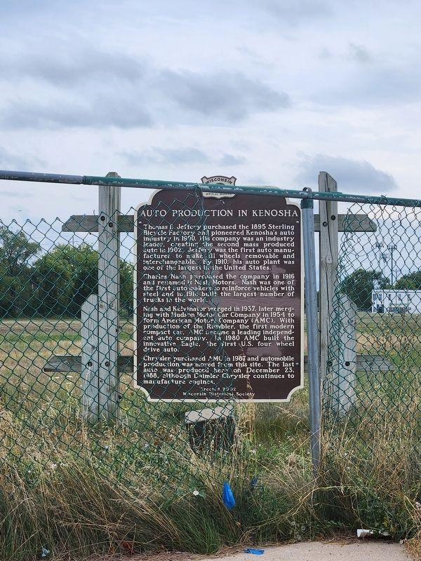
On 56th Street at 24th Avenue, on the left when traveling west on 56th Street.
Thomas B. Jeffery purchased the 1895 Sterling Bicycle Factory and pioneered Kenosha’s auto industry in 1900. His company was an industry leader, creating the second mass produced auto in 1902. Jeffery was the first auto manufacturer to make all . . . — — Map (db m38570) HM
On 59th Place west of 7th Avenue, on the left when traveling west.
In honor of the brave men
of Kenosha County, who
victoriously defended the
Union on land and sea
during the War of the
Great Rebellion.
1861 - 1865. — — Map (db m68501) WM
On Feb. 24, 1845, as Territorial Legislator, he secured enactment of law authorizing free public education in Southport only. As a result first free school in the Union outside of New England opened in Southport, now Kenosha, June 18, 1845. This . . . — — Map (db m38252) HM
On First Avenue at 56th Street, on the right when traveling south on First Avenue.
Native American canoes launched America’s maritime legacy about 12,000 years ago, making them among the world’s oldest watercraft.
Ancient dugout canoes are occasionally preserved when environmental conditions are just right. The canoe above . . . — — Map (db m57837) HM
On 8th Avenue at 60th Street, on the right when traveling south on 8th Avenue.
This historical landmark is dedicated to the worship of God, and to the promotion of Christian knowledge and charity
Chris George Builder
Kenosha Landmarks Commission
Kenosha County Historical Society — — Map (db m38117) HM
Dedicated May 30, 1900
This library building a gift of Zalmon G. Simmons to the citizens of Kenosha as a memorial to his son Gilbert M. Simmons (1852-1890)
His vision and generosity were appreciated by the pioneer town he believed in and . . . — — Map (db m38118) HM
John McCaffary was hanged in Kenosha on August 21, 1851, for the murder of his wife and buried here in an unmarked grave. Public outrage over his execution resulted in legislation that abolished the death penalty in Wisconsin on July 12, 1853. — — Map (db m38121) HM
As early as 1795, the Potawatomi had a mile-long village on the Pike River near here. Fur trader Jacques Vieau Sr.’s son, Peter, wrote the village was called “Kee-neau-sha-Kau-ning,” meaning “the pickerel’s abiding place,” and it “was noted for the . . . — — Map (db m189972) HM
Kemper Hall, boarding school for girls, dates to 1855 when St. Matthew’s Episcopal Church and some dedicated Kenosha citizens signed a charter launching the Kenosha Female Seminary. In 1865, the school moved to this site, the home of U.S. Senator . . . — — Map (db m38122) HM
On Lighthouse Drive, on the left when traveling south.
Built by the federal government in 1866, the Kenosha Lighthouse replaces two other lighthouses constructed at this site in 1848 and 1858. Originally designated a coast and harbor light for Southport, now Kenosha, WI provided the first navigational . . . — — Map (db m147376) HM
On 56th Street at Sheridan Road (Wisconsin Highway 32), on the right when traveling west on 56th Street.
This property
Kenosha County Courthouse
has been placed on the
National Register
of Historic Places
by the United States
Department of the Interior
———————
Kenosha County Courthouse
and Jail
1923-25
City of . . . — — Map (db m69217) HM
For God and Country
Dedicated
in grateful tribute to
those who served in the
Armed Forces of the
United States
"Greater love hath
no man than this.
That a man lay
down his life
for his friends"
John 15:13
Duties are . . . — — Map (db m38257) WM
On 6th Avenue south of 52nd Street, on the right when traveling south.
"The Forgotten War"
This memorial is dedicated to all U.S. military veterans that served in the fight for freedom against the Communist forces on the Korean Peninsula.
"You Are Not Forgotten" — — Map (db m68551) WM
On 6th Avenue south of 52nd Street, on the left when traveling south.
In memory of
Capt. John J. Frost
USNR Retired
WWII Korea
Destroyer Duty
————————
Dedicated in memory of departed shipmates of the Navy, Marines and Coast Guard of Kenosha County . . . — — Map (db m68581) HM
On 6th Avenue at 52nd Street, on the right when traveling south on 6th Avenue.
In tribute to those who served in
Operations
Desert Shield / Storm
Dedicated by
D. I. M. E. S.
Duties in the Middle East Support
Coat of Arms Post 2751
Veterans of Foreign Wars,
and
the Citizens of Kenosha County
July 4, 1992 . . . — — Map (db m68568) WM
On 6th Avenue at 52nd Street (Wisconsin Highway 158), on the left when traveling south on 6th Avenue.
In memory of these men
who gave their lives at
Pearl Harbor and other bases
December 7, 1941
[Roll of Honored Dead
from the State of Wisconsin] — — Map (db m68582) WM
On 7th Avenue at 61st Steet, on the left when traveling north on 7th Avenue.
Deming was born in Vermont in 1789 and came to the Village of Southport, later renamed Kenosha, in 1836. Deming was a Methodist preacher and a staunch supporter of the anti-slavery movement. For Methodists, slavery was considered the worst of social . . . — — Map (db m38119) HM
Born April 1757 in Stratford, CT, Abner Barlow moved to NH in 1772. At 20, Barlow enlisted as private in the NH Rangers, serving in Maj. Whitcomb’s Independent Corps at the Battle of Bennington and the surrender of Burgoyne, Saratoga, NY. In . . . — — Map (db m38240) HM
On Simmons Island Road, on the right when traveling north.
Erected in honor of Z.G. Simmons and his heirs whose generosity made possible this public park.
This park is a perpetual memorial to Kenosha's public spirited citizens and as years go by a lasting source of pleasure to Kenosha men women and . . . — — Map (db m68516) HM
On 11th Avenue at 58th Street, on the left when traveling south on 11th Avenue.
This boulder is placed by the Kenosha Chapter of Daughters of the American Revolution to mark the site of the first free school outside of New England in the Union. It was opened June 18, 1845. The pioneers in this work were: Michael Frank . . . — — Map (db m69637) HM
On Simmons Island Road 0.1 miles east of 4th Avenue, on the right when traveling north.
In 1923 the Kenosha Chapter, Daughters of the American Revolution commemorated the Pine Creek settlement of 1835 by placing a plaque on the tower of the 6th Avenue lift bridge. This marker is now given its own special place on Simmons Island. . . . — — Map (db m65973) HM
On 3rd Avenue at 58th Street, on the right when traveling north on 3rd Avenue.
Placed to commemorate the Winter Dance Party held in Kenosha at The Eagles Ballroom, corner of 58th Street and 3rd Avenue
"The Day the Music Died" occurred only days later when the plane carrying three of the four stars crashed in Clear Lake, . . . — — Map (db m253795) HM
On 6th Avenue at 52nd Street, on the right when traveling south on 6th Avenue.
Kenoshans have fought and died in seven wars, leaving a legacy of courage and devotion, and a selfless contribution to our survival as a free nation.
This boulder is from a World War Two battle area near the city of Naha, Okinawa. The sand is . . . — — Map (db m68567) HM WM
On 52nd Street (State Highway 158) at 6th Avenue, on the right when traveling east on 52nd Street.
It is to the members of our Armed Forces from the City and County of Kenosha who sacrificed their lives defending our freedom that this memorial is dedicated. It stands as a tribute to all of our veterans.
[Roll of Honored Dead]
Mexican War . . . — — Map (db m68584) HM WM
On 12th Street 1 mile west of 136th Avenue, on the right when traveling west.
Over 12,000 years ago, Native Americans slaughtered a Northern Woolly Mammoth in a small lake near this site. Between 1992-93, the Kenosha Public Museum excavated the site and concluded that the woolly mammoth stood at 11 feet and weighed 14,000 . . . — — Map (db m38569) HM
Wisconsin women rallied to support the Union during the Civil War. They became nurses, hospital matrons, sanitary agents, and ministers. Cordelia A. Perrine Harvey attained national prominence for her role in promoting convalescent aid for sick and . . . — — Map (db m36392) HM
On Green Bay Road (State Highway 31) at 95th Street, on the right when traveling north on Green Bay Road.
Green Bay Road was the main route of settlement and communication in 19th century eastern Wisconsin. The road followed an ancient Indian trail network and was surveyed for use as a military road between Fort Dearborn (Chicago) and Fort Howard (Green . . . — — Map (db m66625) HM
On Interstate 94 at Wisconsin Highway 165 on Interstate 94.
In 1673, thirty-nine years after Jean Nicolet visited the Green Bay area, Father Jacques Marquette and Louis Jolliet set out from New France to explore the Mississippi River. They traveled from the Straits of Mackinac between lakes Huron and . . . — — Map (db m36671) HM
On State Highway 32 0.5 miles north of State Highway 165, on the right when traveling north.
The 32nd Division was organized in 1917. Originally it was made up of National Guardsmen from Wisconsin and Michigan.
World War I: Fought in Alsace, Aisne-Marne, Olse-Aisne and Meuse-Argonne Offensives. Vanquished 23 German Divisions. Served in . . . — — Map (db m36339) HM
On 75th Street (State Highway 50) at 256th Avenue (State Highway 83), on the left when traveling west on 75th Street.
In the 1800’s, before assigning names to roads was a common practice, intersections were often given names to identify communities and places of interest.
The trail through Brass Ball Corners started at Lake Michigan and went west through . . . — — Map (db m114066) HM
On Lincoln Avenue 0.1 miles east of Mound Street, on the right when traveling east.
Johanna "Jennie" Brotch, considered Bay View's first female ship owner, lived in this house from 1890 to 1949. Emigrating from Prussia in 1869, she owned two schooners - the Sassacus and the Arctic - sailed by her husband, Captain John Brotch. . . . — — Map (db m254390) HM
On W Green Brook Dr 0.2 miles north of W. Brown Deer Rd., on the right when traveling west.
The Little White Schoolhouse was built in 1884 in Old Brown Deer, enlarged in 1900, and used as a school for grades 1-8 until 1922. It was moved in 1972 and restored by the Brown Deer Historical Society with funds donated by the Community. Since . . . — — Map (db m78922) HM
On North Fox Lane 0.2 miles south of East Dean Road, on the left when traveling south.
A hewn-log schoolhouse was erected on this site during the winter of 1852-53 by school district no. 9, Township of Milwaukee. The structure was also used as a public meeting house, and for church services by the Reformed Church of Bethlehem, a Dutch . . . — — Map (db m125613) HM
On South 27th Street 0.2 miles north of West Drexel Avenue.
The 41 Twin Outdoor Theatre, the second drive-in built in Wisconsin, occupied this site from July 1, 1948 until September 16, 2001. The 41 Twin was one of a handful of outdoor theaters throughout the United States to make use of a double-sided . . . — — Map (db m35836) HM
On West Ryan Road (Wisconsin Route 100) west of Alternate Interstate 94, on the right when traveling west.
Built by Protestants from Wittenburg, Germany who settled in Franklin and Oak Creek. The chapel served the first free congregation in Wisconsin
The building was also used as an Army Depot during the Civil War as well as by the Underground . . . — — Map (db m288685) HM
On Board St. at Northway St., in the median on Board St..
Visitors keep saying,
"Greendale looks like a Norman Rockwell town."
For good reason. Greendale was designed by
a town planner from New England... who gave the
village a definite "New England feel"... resulting in
the type of town that . . . — — Map (db m232493) HM
On West Grange Avenue 0.5 miles west of South 76th Street, on the right when traveling east.
Born in Detroit to Irish immigrant parents, Curtin came to Milwaukee in 1837 to join his mother’s family the Furlongs and settle on a farm in Greenfield. In the 1840’s the Curtins moved into this typically Irish stone house described in Curtin’s . . . — — Map (db m34760) HM
On W. Grange Ave. 0.2 miles east of S. 92nd Street, on the right when traveling east.
Lime production was an important nineteenth century industry in southeastern Wisconsin, primarily because the region’s geology provided abundant Silurian dolomite rock that was easily quarried. High quality lime, used mainly in mortar and plaster, . . . — — Map (db m37508) HM
On Schoolway at Parking Street, on the left when traveling east on Schoolway.
This building was built during the Great Depression by the Federal Government between the years 1936 and 1938. Historically this site has served as the Police and Fire Department, the municipal court, and was the central heating plant for the . . . — — Map (db m183768) HM
Near Broad Street south of Northway, on the right when traveling south.
The economic depression of the 1930's left millions of Americans looking for affordable housing. The notion of creating "Greenbelt Communities" outside major cities was part of the Roosevelt Administration's "New Deal" to provide new housing and . . . — — Map (db m184179) HM
On Broad Street at Schoolway, on the right when traveling south on Broad Street.
Alonzo Hauser, a Wisconsin native and noted sculptor, was commissioned by the WPA in 1938 to execute this flagpole grouping for the new village of Greendale. The sculpture memorializes the mothers, youths, and working people who were to populate . . . — — Map (db m184115) HM
On Broad Street south of Northway, on the right when traveling north.
In 1934 the government chose this site -- 3,410 acres which had previously been dairy farms -- for one of the nation's three "Greenbelt Communities". It was selected due to its gentle hills, thick woods and clean ponds. Greendale's been called, "One . . . — — Map (db m183649) HM
Near Broad Street south of Northway, on the right when traveling south.
The farms that occupied this land prior to 1936 were regarded as an ideal site for one of the nation's three "Greenbelt Communities". These gentle hills, thick woods and clear ponds—tucked at the edge of 660-acre Whitnall Park—promised a unique and . . . — — Map (db m184180) HM
Near Broad Street south of Northway, on the right when traveling south.
In just 2 years, thousands of workers completed 366 buildings containing 572 living units. Over 100 families moved in during the first 2 weeks of May in 1938. Uniquely, each house was located close to the street, and the living room was positioned . . . — — Map (db m184164) HM
On Broad Street south of Northway, on the left when traveling south.
First Lady Eleanor Roosevelt personally visited Greendale in 1936 as this massive project was underway. After touring several houses and this downtown area, she said Greendale "is absolutely wonderful" and "is laid out beautifully". Thousands of . . . — — Map (db m183642) HM
Near Broad Street south of Northway, on the right when traveling south.
First Lady Eleanor Roosevelt, who had a high regard for the welfare of children and a great concern for impoverished people, visited Greendale in 1936 to personally inspect this "Greenbelt" project. After clambering through one of the two-story . . . — — Map (db m184167) HM
On Broad Street at Schoolway, on the left when traveling south on Broad Street.
This gazebo was built by Greendale volunteers in 1995 as the new "gathering place". Early residents used to gather under a giant elm tree on the east side of Broad Street, before stores were built there. To fund the gazebo, anyone contributing $25 . . . — — Map (db m183070) HM
On Broad Street south of Northway, on the right when traveling south.
To ease managing more than 2,000 men during Greendale's construction, workers were directed to the "A section", the "D section", etc. This alphabetical reference has endured. Still today, all streets in each section begin with the same letter . . . — — Map (db m183617) HM
On Broad Street south of Northway, on the left when traveling north.
The economic depression of the 1930's left millions of American's lacking for affordable housing. The notion if creating "Greenbelt Communities" was part of the Roosevelt Administration's "New Deal" program, aimed at providing needed housing and . . . — — Map (db m183618) HM
Near Schoolway east of Broad Street, on the left when traveling east. Reported missing.
…had its beginnings in 1936, when the U.S. Department of Agriculture began construction of three new communities known as the Greenbelt towns. Besides Greendale, the other two towns are Greenbelt, Maryland and Greenhills, Ohio.
In the center . . . — — Map (db m272891) HM
On Northway at Broad Street, on the right when traveling east on Northway.
Visitors often say Greendale reminds them of New England. That's partly because the town planner, Elbert Peets, was from New England. It was his idea to position the homes very near the curb and turn all of them "backwards". That way the large . . . — — Map (db m182897) HM
On Schoolway at Parking Street, on the right when traveling west on Schoolway.
The Hose Tower and Grounds Building was built in 1939 in Greendale a planned community built by United States Government to provide jobs and housing in the era of the Great Depression. The Greendale Volunteer Fire Department used the tower to dry . . . — — Map (db m183793) HM
On Parking Street north of Schoolway, on the right when traveling north.
This building was originally the "Greendale Theatre". It opened in 1939 with a feature starring Mickey Rooney as Andy Hardy. To boost attendance during the Great Depression, "dish nights" were popular - free cups, plates, etc. were handed out weekly . . . — — Map (db m183845) HM
On Broad Street south of Northway, on the right when traveling south.
The lower level held Greendale's first Post Office, which opened on December 16th, 1938. The first Greendale Postmaster was Ed Bengs; he was also a Greendale resident. In 1938 postage for a first-class letter was 3 cents!
The upper level was . . . — — Map (db m182905) HM
On Northway at Broad Street, on the right when traveling west on Northway.
Greendale was one of three Greenbelt towns constructed by the Federal Government during the 1930s. The main objectives were to demonstrate a planning concept combining the best of country and city living, to provide good housing for low income . . . — — Map (db m33210) HM
Alan Kulwicki was born in Greenfield, WI on Dec. 14, 1954, son of Jerry and Thelma Kulwicki. Alan held an engineering degree from the University of Wisconsin-Milwaukee.
Alan started out on the short tracks of Wisconsin, moved up to ASA, then on . . . — — Map (db m37506) HM
On West Layton Avenue 0.2 miles east of South 60th Street, on the right when traveling east.
Built in 1832, this was one of Greenfield’s first log cabins. It was dismantled, brought to this site and restored by the Greenfield Historical Society, and dedicated as a museum September 7, 1969. — — Map (db m32842) HM
On Cold Spring Road 0.1 miles east of South 108th Street ( Highway 100), on the right when traveling east.
Side A In 1836, surveyors working for the U.S. General Land Office measured out the 6x6 mile grid of the future Town of Greenfield. Arterial roads and streets were later built at half-mile intervals following that pattern. In the days before . . . — — Map (db m35083) HM
Following the end of World War II, Milwaukee’s rapid urban development forced the seven rural towns of Milwaukee County into annexation or incorporation. When Greenfield incorporated as a city in 1957, the last of Milwaukee County’s towns . . . — — Map (db m34761) HM
On West Beloit Road 0.5 miles west of South 108th Street ( Highway 100), on the right when traveling west.
The Root River system began forming about 20,000 years ago when Wisconsin’s glaciers began to retreat. Starting in eastern New Berlin, it flows through southwest Milwaukee County before entering Lake Michigan at the city of Racine (French for . . . — — Map (db m81350) HM
On West Forest Home Avenue 0.2 miles west of South 92nd Street, on the right when traveling south.
Side A:
The Janesville Plank Road was one of 16 privately-owned toll roads authorized by Wisconsin’s Territorial legislature in 1848. The road was specified to follow a 65 mile route from Milwaukee through East Troy to Janesville. Its . . . — — Map (db m33355) HM
On W. Morgan Avenue at S. 51st Street, on the right when traveling west on W. Morgan Avenue.
The first congregation of the Evangelical United Brethren Church in Wisconsin worshipped God here.
The Centennial Historical Museum
Nearby, built in 1858, replaced the first log church erected in 1844. Dedicated in honor of John Lutz, . . . — — Map (db m110107) HM
Near West Layton Avenue 0.5 miles east of South 60th Street.
The Land Survey of 1836
In 1836 US Government land surveyors measured an approximately six-mile square area described as Township 6 North, Range 21 East and divided it into a nearly-uniform grid of 36 one-mile square sections. By 1841 this area . . . — — Map (db m136420) HM
On West Janesville Road at South 110th Street on West Janesville Road.
Two subdivisions, the oldest in the Village, are included in this 2.1 mile tour. The one square block Scholz subdivision at Hwy 100 and Janesville Rd. was recorded in 1904, the year the Rapid Transit train came through Hales Corners. Milwaukee . . . — — Map (db m83956) HM
Near Whitnall Park Drive at Boerner Drive, on the left when traveling north.
Africa has a rich botanical heritage. So many unique and necessary plants from this continent have made their way around the world from castor beans to watermelons, okra to ancient grains.
Generations of African farmers selected, perfected . . . — — Map (db m182792) HM
On West Forest Home Avenue 0.2 miles east of South 108th Street ( Highway 100), on the right when traveling east.
Hales Corners grew into a Village after the Civil War. New homes and businesses were established along the Janesville Plank Road, the most important road in the Village.
Adam Conrad erected his Opera House at this
approximate location on the . . . — — Map (db m76062) HM
On West Forest Home Avenue 0.2 miles east of South 108th Street ( Highway 100), on the right when traveling east.
Native Americans were the earliest inhabitants of Hales Corners. In 1833 the Potawatomi, who possessed the land at the time, relinquished their rights in a treaty with the U.S. Government.
Settlers soon came. Seneca Hale claimed land here in . . . — — Map (db m76039) HM
On West Forest Home Avenue 0.2 miles east of South 108th Street ( Highway 100), on the right when traveling west.
Tradition says the first business in Hales Corners dates back to 1834 when a log cabin close to this spot served as a home, a store and an inn. It was later named the Western Hotel. In 1847-48, William Shields owned the land, and on it Simon . . . — — Map (db m83955) HM
On S. 108th Street (State Highway 100) at West Forest Home Avenue, on the right when traveling north on S. 108th Street. Reported missing.
The arrival in 1903 of the Rapid Transit, an electric train, marked the beginning of the transition of Hales Corners from a farm village to a suburban community. People began to build their homes in the village with the intention of commuting to . . . — — Map (db m83954) HM
On Boerner Drive west of South 92nd Street, on the right when traveling west.
Named in honor of former Director, Mr. John Voight, and his wife Hildegarde. John Voight was appointed Gardens Director from the ranks of the CCC/WPA (Civilian Conservation Corps/Works Progress Administration) where he served as a crew leader in . . . — — Map (db m182849) HM
On West Edgerton Avenue 0.1 miles north of West Forest Home Avenue ( Highway 24), on the right when traveling west.
Saint Mary’s, the oldest church in the area, has a recorded history dating from 1842. At that time Father Patrick O’Kelley was the priest in attendance and a log church had been constructed on the present cemetery site. The second church, a frame . . . — — Map (db m76063) HM
On West Forest Home Avenue 0.1 miles east of South 108th Street ( Highway 100), on the right when traveling east.
The German Evangelical Church
The first Protestant church in hales Corners was founded here in 1888 on land purchased from William Cobb. Services were held in German until that language became unpopular during World War I. The minister at . . . — — Map (db m76040) HM
On North 26th Street north of West Atkinson Avenue, on the right when traveling north.
The Garden Homes Historic District was the first municipally sponsored housing project in America. Safe, decent, and affordable housing for working-class families had long been a goal of the Socialists who came to power in Milwaukee in 1910. Mayor . . . — — Map (db m227182) HM
On South 1st Street at East Pittsburgh Avenue ( Road 32) on South 1st Street.
Author of Walden and Civil Disobedience
who inspired Gandhi and M. L. King
Stayed at the Lakehouse Hotel near this site on June 27, 1861 — — Map (db m254855) HM
On North Doctor Martin Luther King Junior Drive north of West Highland Avenue, on the right when traveling north.
In this vicinity, Kilbourntown, one of three original Milwaukee settlements, was founded by surveyor and land speculator Byron Kilbourn in 1835. Kilbourntown's first residents were entrepreneurs from the East. In 1839, a small group of German . . . — — Map (db m255190) HM
On South Lincoln Memorial Drive at Lake Express Ferry, on the right when traveling south on South Lincoln Memorial Drive.
This navigation buoy, which dates back to the early
days of this century, was used to guide vessels
bound to or coming from the Port of Antwerp.
Among others, this buoy guided U.S. Navy and
merchant ships bringing supplies to the U.S. . . . — — Map (db m254968) HM
On East Knapp Street at North Broadway, on the left when traveling east on East Knapp Street.
The American Dream became a reality on this site in 1914 as a group of intrepid hard-working immigrants built Wisconsin’s First Annunciation Greek Orthodox Church. Proud of their heritage, they were strangers in a strange land but like so many . . . — — Map (db m294667) HM
St. Boniface and its campus at 1122 W. Clarke Street were the epicenter of Milwaukee’s civil rights movement. A Catholic church with a predominantly Black congregation, St. Boniface served as a hub during the 200 consecutive days of open housing . . . — — Map (db m235789) HM
On West Wisconsin Avenue west of North 20th Street, on the right when traveling west.
Of German birth, Pabst became a ship's captain in the 1850s and moved to Milwaukee in the 1860s. He later joined his father-in-law's brewery (founded 1844), which was renamed the Pabst Brewery in 1889. By the 1890s it was the world's largest lager . . . — — Map (db m8306) HM
On West Wisconsin Avenue at North 11th Street, on the right when traveling east on West Wisconsin Avenue.
Mabel Raimey was the first African-American woman attorney in Wisconsin and the first to graduate from the University of Wisconsin-Madison (1918). She attended Marquette University Law School and was admitted to the Wisconsin Bar in 1927. An . . . — — Map (db m95799) HM
On West Wisconsin Avenue at North 12th Street on West Wisconsin Avenue.
Designed by Henry C. Koch and Co., dedicated in 1894, and designated in 1975 as a Milwaukee landmark in recognition of its architectural and historical significance to the city. — — Map (db m43014) HM
On South Kinnickinnic Avenue north of East Ward Street, on the right when traveling north.
From a quiet mid 19th–century farming community to a bustling industrial center along Kinninckinnic Avenue in only twenty years, Bay View’s industrial transformation could not have occurred without the contributions of hundreds of immigrant . . . — — Map (db m34803) HM
On East Russell Avenue at South Superior Street, on the right when traveling west on East Russell Avenue.
Near this site in Bay View stood the Milwaukee Iron Company rolling mill, the first major heavy industry in the region and an important producer of iron and steel for the Midwest. The mill, which opened in 1868, transformed ore from Dodge County and . . . — — Map (db m75452) HM
On East Layton Avenue 0.5 miles east of South Howell Avenue, on the right when traveling east.
On October 29, 1926, Milwaukee County purchased the flying field which Thomas Hamilton had established in 1920 on East Layton Avenue in connection with his propeller business. Northwest Airways inaugurated scheduled passenger service here on July 5, . . . — — Map (db m38870) HM
On Maryland Avenue 0.2 miles East Hartford Avenue, on the right when traveling north.
Carl Sandburg (1878-1967), poet, balladeer, biographer of Lincoln, soldier in the Spanish-American War, came from Illinois to Wisconsin in December 1907 as a state organizer for the Social-Democratic party in eastern Wisconsin. After marrying . . . — — Map (db m32619) HM
Near Hartford Avenue 0.1 miles east of North Maryland Avenue.
The UWM Library is named for Golda Meir. Born Goldie Mabowehz in the Ukraine, she migrated to Milwaukee in 1906, was educated at Fourth Street School, North Division High School, and in present Mitchell Hall of Milwaukee Normal School (1916-17). She . . . — — Map (db m32664) HM
On East Hartford Ave at North Downer Avenue on East Hartford Ave.
On September 14, 1848, Mrs. William L. Parsons, the wife of a Congregational minister, opened the Milwaukee Female Seminary at the corner of Milwaukee and East Wells. Three years later it was chartered by the Legislature, thus placing Wisconsin in . . . — — Map (db m32667) HM
On East Hartford Avenue at North Downer Avenue, on the right when traveling west on East Hartford Avenue.
This set of four buildings, including Merrill, Johnston, and Holton Halls and Greene Memorial Library, designed by A. C. Eschweiler and erected in 1897–1905, was designated as a Milwaukee Landmark in 1973 in recognition of its architectural . . . — — Map (db m59605) HM
984 entries matched your criteria. The first 100 are listed above. Next 100 ⊳